®
Reprinted with permission from the October 2008 issue
Predicting Sudden Changes
In Wind Power Generation
The varying sets of challenges that accompany ramp-event forecasting
are dependent on the nature of the weather event causing the ramp.
By Noah Francis
T
he ability to predict sudden,
significant changes in wind
power generation is emerging
as a top priority for grid managers. In
most cases, forecasts of hour-by-hour
generation over the next day – or two
– solve the grid operator’s wind integration problem. However, an unforeseen ramp-up or ramp-down in
generation – so-called ramp events
– can leave operators scrambling to
balance supply and demand while inducing substantial costs.
There are varying sets of challenges that accompany ramp-event
forecasting, each dependent on the
nature of the weather event causing
the ramp. Some challenges are manageable, while others require more
research and experimentation with
untried techniques before an acceptable solution is found.
Ramp events can be forced by
weather features, such as synopticscale (i.e., larger-scale) areas of high
and low pressure. An example is the
Feb. 26 fall-off of generation experienced in the Electric Reliability
Council of Texas (ERCOT) footprint.
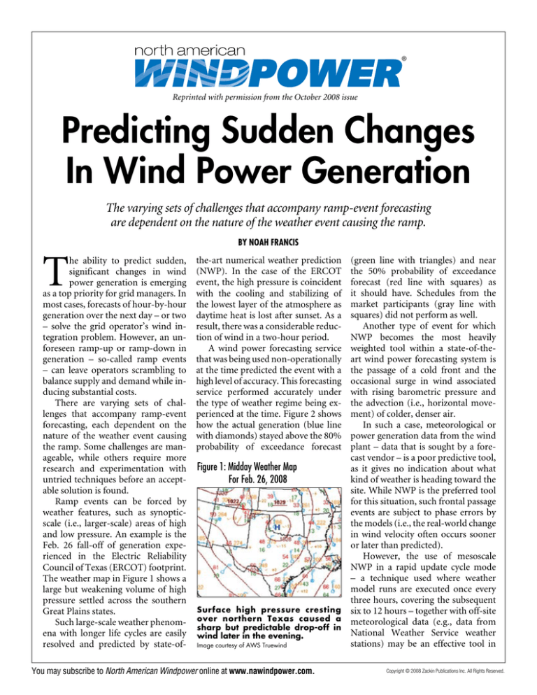
The weather map in Figure 1 shows a
large but weakening volume of high
pressure settled across the southern
Great Plains states.
Such large-scale weather phenomena with longer life cycles are easily
resolved and predicted by state-of-
(green line with triangles) and near
the 50% probability of exceedance
forecast (red line with squares) as
it should have. Schedules from the
market participants (gray line with
squares) did not perform as well.
Another type of event for which
NWP becomes the most heavily
weighted tool within a state-of-theart wind power forecasting system is
the passage of a cold front and the
occasional surge in wind associated
with rising barometric pressure and
the advection (i.e., horizontal movement) of colder, denser air.
In such a case, meteorological or
power generation data from the wind
plant – data that is sought by a forecast vendor – is a poor predictive tool,
Figure 1: Midday Weather Map
as it gives no indication about what
kind of weather is heading toward the
For Feb. 26, 2008
site. While NWP is the preferred tool
for this situation, such frontal passage
events are subject to phase errors by
the models (i.e., the real-world change
in wind velocity often occurs sooner
or later than predicted).
However, the use of mesoscale
NWP in a rapid update cycle mode
– a technique used where weather
model runs are executed once every
three hours, covering the subsequent
Surface high pressure cresting six to 12 hours – together with off-site
over northern Texas caused a meteorological data (e.g., data from
sharp but predictable drop-off in
National Weather Service weather
wind later in the evening.
stations) may be an effective tool in
Image courtesy of AWS Truewind
the-art numerical weather prediction
(NWP). In the case of the ERCOT
event, the high pressure is coincident
with the cooling and stabilizing of
the lowest layer of the atmosphere as
daytime heat is lost after sunset. As a
result, there was a considerable reduction of wind in a two-hour period.
A wind power forecasting service
that was being used non-operationally
at the time predicted the event with a
high level of accuracy. This forecasting
service performed accurately under
the type of weather regime being experienced at the time. Figure 2 shows
how the actual generation (blue line
with diamonds) stayed above the 80%
probability of exceedance forecast
You may subscribe to North American Windpower online at www.nawindpower.com.
Copyright © 2008 Zackin Publications Inc. All Rights Reserved.
Figure 2: Wind Power Forecast: Feb. 26, 2008.
MW
2,500
2,000
Hour Ave. Actual Output
1,500
50% Wind Power Forecast
1,000
80% Wind Power Forecast
500
10
11
Resource Plan From WGRs
In Day-Ahead
12
13
14
15
16
17
18
19
20
21
22
23
24
Hour Ending
Courtesy of ERCOT
this case. This approach can greatly
reduce the phase errors with each
subsequent model run and fine-tune
the amplitude prediction.
A significant change in power
generation borne from large-scale
weather features may be effectively
predicted by weather models; however, smaller-scale weather features
with shorter life cycles can be more
problematic. Strong winds produced
by a thunderstorm cluster can be
considered as an example. While it
is possible to model such a feature
(represented in Figure 3) with highresolution, mesoscale NWP, accurately
predicting the precise characteristics of
the feature is highly unlikely.
In Figure 3, the radar site is the
black circular void immediately
north of Sioux Falls. Green sections
represent air moving toward the radar site, and red sections represent air
moving away. The bright green sections southwest of the radar site (just
east of Parker) show a strong wind
field that is roughly eight kilometers
in horizontal scale.
It is very unlikely that a weather
model would be able to predict this
feature with a level of accuracy meaningful to a grid manager. Even if
the NWP being employed correctly
predicts the development of a large
thunderstorm cluster, there is a good
chance the model will handle the
evolution and timing of the feature
poorly and incorrectly predict the
velocity of the thunderstorm winds.
Thus, predicting ramps in power generation borne from such a feature is
extremely difficult.
Some ramp events are caused by
vertical processes in the atmosphere.
For example, if a wind plant lies within
a cold, stable airmass, winds at turbinehub height may be light, while winds 100
meters higher may be quite strong. If the
atmosphere is allowed to mix vertically
– a process that is common when the
sun’s radiation warms the lowest level
of the atmosphere – the stronger wind
resource aloft will be realized eventually, as upward and downward currents
in the atmosphere transfer the wind energy down to the plant.
Such a diurnal, cyclical process
may be well-predicted by climatology
or statistical methods. Other cases
may be very difficult to predict, such
as cases in which a nocturnal jet – a
wind phenomenon commonly experienced in the Plains – flows above a
wind plant only partially covered by
a stable layer, and the turbine blades
are allowed to experience the stronger
winds from time to time through sporadic mixing. In this case, numerous
ramps may be experienced over a period of several hours.
Finally, ramp events may be the
result of wind turbine cut-out, where
winds reach the cut-out threshold of
the turbine model, resulting in the
immediate reduction of power generation for either all or some of the
generators within a wind plant. Arguably, this is the most feared and dif-
You may subscribe to North American Windpower online at www.nawindpower.com.
ficult scenario to predict, and it could
be the result of a smaller-scale weather
feature, such as a thunderstorm complex, or a larger-scale feature, such as
extreme wind flow between a region
of high and deep low pressure.
In either case, when winds flirt with
cut-out speed, a very small change in
the wind speed can take power generation from plant capacity to zero and
back again over a sub-hour interval.
Consider a plant filled with turbines
that cut out at 25 meters per second.
Now, consider a forecast that calls for
wind speeds between 23 meters and
26 meters per second over a one-hour
time interval.
How does the forecasting system
translate that into power prediction?
What percentage of turbines will cut
out during that time and for how long?
What if the forecast is off by one meter
per second? Certain cut-out events and
resulting reductions in power generation can be extremely difficult, if not
impossible, to predict, at least with
current forecasting methods.
Significant ramp events are relatively rare, but an effective forecasting solution for that handful of hours
each year may mean more to a grid
manager than does the general forecasting solution for all the remaining
hours. Solutions to the problem vary
dramatically, and there is no one solution that fits all ramp cases.
In some instances, a deterministic
forecast of wind power generation can
be produced with an acceptable level
of accuracy. In the previously noted
example, a spike in wind associated
with a cold, winter airmass surge can
be predicted with rapid update cycle
NWP supplemented with off-site, upstream meteorological data. This forecasting system configuration would
incur a higher cost, given the added
computational efforts of the update
cycle, but the cost may be justified if
the forecast user is sensitive enough to
such an event.
In other instances, such as a spike
in wind associated with wind outflow
from a large thunderstorm, a probabilistic forecast is needed. As mentioned
Copyright © 2008 Zackin Publications Inc. All Rights Reserved.
previously, a single thunderstorm exists on a time-and-space scale that is
too small to be modeled effectively by
current NWP techniques, and a deterministic forecast covering such an
event could not be reliably produced.
Still, the grid operator needs information to manage such an event.
In this case, a probabilistic forecast
could flag the event for a grid operator. Real-time radar data coupled
with state-of-the-art pattern recognition techniques in conjunction with
warnings from local National Weather
Service offices are tools that could be
used to generate such a probabilistic
Figure 3: Doppler Radar Representation Of Strong Outflow Winds Associated With Thunderstorms
forecast. Instead of a power generation forecast, the user would receive
the probability of exceeding a certain
threshold; in this case, a change in generation over a given amount of time.
A cutting-edge ramp-event forecasting service may feature an awareness element that could guide the user
toward realizing the event’s cause,
whether it is a drop-off in power generation due to winds reaching cutout speed from a large thunderstorm
complex or a spike in generation from
the passage of a strong autumn cold
front.
The tools needed to produce this
level of forecast sophistication have
either yet to be perfected or yet to be
developed, but they will be. Operators
of power grids and large wind power
generator fleets have spoken at wind
energy and utility conferences alike,
and the demand is clear – produce
forecasts designed to predict significant swings in wind power generation
and give operators better tools to aid
in balancing these swings in the realtime market or scheduling reserves in
the day-ahead market. w
Noah Francis is forecasting business
manager for AWS Truewind. He can be
reached at nfrancis@awstruewind.com.
Image courtesy of National Weather Service Weather Forecast Office, Sioux Falls, S.D.
You may subscribe to North American Windpower online at www.nawindpower.com.
Copyright © 2008 Zackin Publications Inc. All Rights Reserved.
