RIVERS AND MEMORY
advertisement
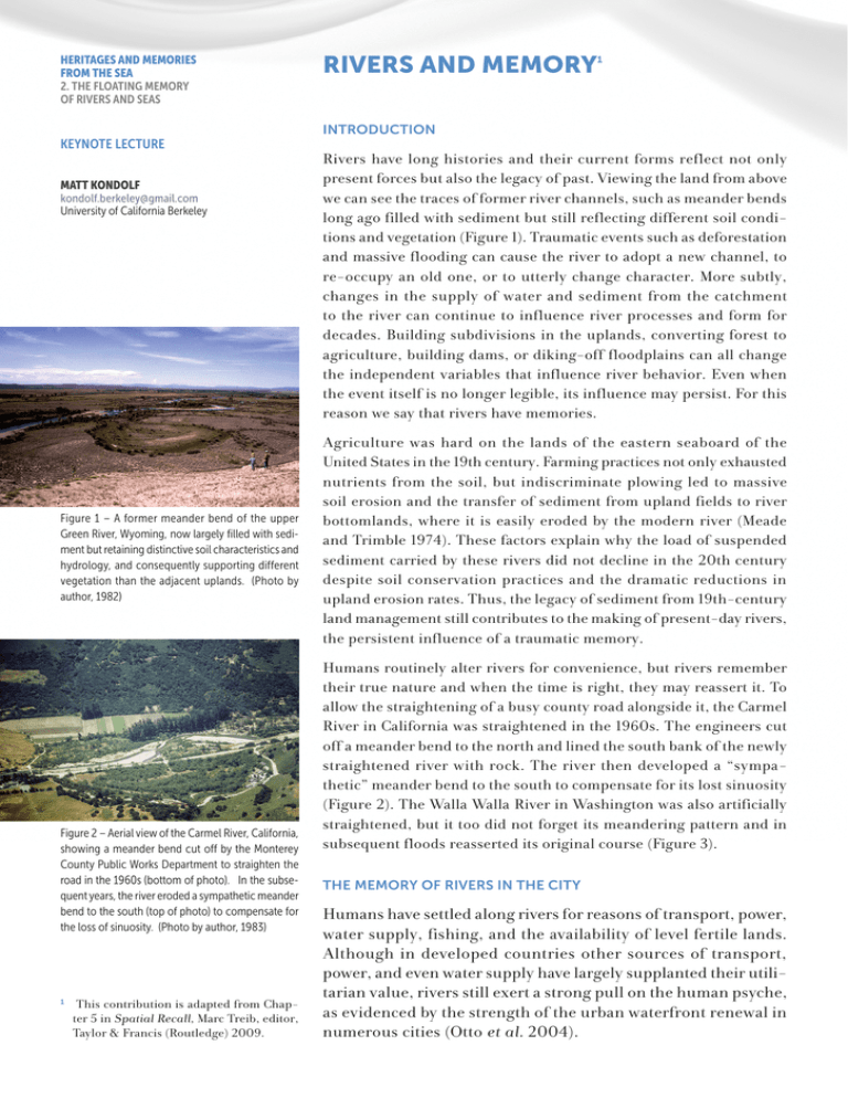
HERITAGES AND MEMORIES FROM THE SEA 2. THE FLOATING MEMORY OF RIVERS AND SEAS KEYNOTE LECTURE MATT KONDOLF kondolf.berkeley@gmail.com University of California Berkeley Figure 1 – A former meander bend of the upper Green River, Wyoming, now largely filled with sediment but retaining distinctive soil characteristics and hydrology, and consequently supporting different vegetation than the adjacent uplands. (Photo by author, 1982) Figure 2 – Aerial view of the Carmel River, California, showing a meander bend cut off by the Monterey County Public Works Department to straighten the road in the 1960s (bottom of photo). In the subsequent years, the river eroded a sympathetic meander bend to the south (top of photo) to compensate for the loss of sinuosity. (Photo by author, 1983) This contribution is adapted from Chapter 5 in Spatial Recall, Marc Treib, editor, Taylor & Francis (Routledge) 2009. 1 RIVERS AND MEMORY 1 INTRODUCTION Rivers have long histories and their current forms reflect not only present forces but also the legacy of past. Viewing the land from above we can see the traces of former river channels, such as meander bends long ago filled with sediment but still reflecting different soil conditions and vegetation (Figure 1). Traumatic events such as deforestation and massive flooding can cause the river to adopt a new channel, to re-occupy an old one, or to utterly change character. More subtly, changes in the supply of water and sediment from the catchment to the river can continue to influence river processes and form for decades. Building subdivisions in the uplands, converting forest to agriculture, building dams, or diking-off floodplains can all change the independent variables that influence river behavior. Even when the event itself is no longer legible, its influence may persist. For this reason we say that rivers have memories. Agriculture was hard on the lands of the eastern seaboard of the United States in the 19th century. Farming practices not only exhausted nutrients from the soil, but indiscriminate plowing led to massive soil erosion and the transfer of sediment from upland fields to river bottomlands, where it is easily eroded by the modern river (Meade and Trimble 1974). These factors explain why the load of suspended sediment carried by these rivers did not decline in the 20th century despite soil conservation practices and the dramatic reductions in upland erosion rates. Thus, the legacy of sediment from 19th-century land management still contributes to the making of present-day rivers, the persistent influence of a traumatic memory. Humans routinely alter rivers for convenience, but rivers remember their true nature and when the time is right, they may reassert it. To allow the straightening of a busy county road alongside it, the Carmel River in California was straightened in the 1960s. The engineers cut off a meander bend to the north and lined the south bank of the newly straightened river with rock. The river then developed a “sympathetic” meander bend to the south to compensate for its lost sinuosity (Figure 2). The Walla Walla River in Washington was also artificially straightened, but it too did not forget its meandering pattern and in subsequent floods reasserted its original course (Figure 3). THE MEMORY OF RIVERS IN THE CITY Humans have settled along rivers for reasons of transport, power, water supply, fishing, and the availability of level fertile lands. Although in developed countries other sources of transport, power, and even water supply have largely supplanted their utilitarian value, rivers still exert a strong pull on the human psyche, as evidenced by the strength of the urban waterfront renewal in numerous cities (Otto et al. 2004). 65 HERITAGES AND MEMORIES FROM THE SEA 2. THE FLOATING MEMORY OF RIVERS AND SEAS Figure 3 – Aerial view of the Walla Walla River, Washington. The river was straightened between two dykes, but during a flood in 1965 it broke through these dykes, reasserting a meandering pattern. (Photo courtesy of the US Army Corps of Engineers) As cities have urbanized, the smaller creeks have been buried in underground culverts and are largely forgotten – that is, until the culverts begin to fail and we are reminded that there are creeks beneath them. Buried rivers in London and Philadelphia, for example, are still evident in their urban form (Barton 1962, Spirn 1998). In Berkeley, California, most of the creeks were buried in the 20th century, but sensing their loss, a local creek group has stenciled patterns on curbs to show the underground course of buried streams in the city – a way of retaining the memory of these lost waterways. And in recent years it has become increasingly more common to “daylight” these buried creeks and restore them as free-flowing surface channels (Figure 4). In addition to breaking up and removing the concrete pipes that had contained the streams, daylighting projects may involve varying degrees of channel design and development of adjacent parks or commercial areas. Figure 4 – Strawberry Creek emerges from an underground culvert in Berkeley, California. The creek was exhumed from the pipe in the 1980s, an early and influential example of urban stream “daylighting”. (photo by author, 1992) Figure 5 – The urban form of Wasserberg, Bavaria, reflects its history of urban growth onto an accreting point bar, as the channel migrated away from the city and the point bar grew. Newer buildings were constructed on more recently deposited sediment. (Adapted from Fluesse und Bäche, erhalten-entwickeln-gestalten, Wasserwirtschaft in Bayern, Oberste Baubehörde im Bayerischen Staatsministerium des Innern, Heft 21. München, 1989, used by kind permission of Walter Binder) Given the close historical dependence of cities on rivers it is not surprising that the basic forms of many cities have been inherited from the fluvial landforms upon which they were built. Meander bends typically have an eroding, high bank on the outer edge of the bend, with a lower point bar forming as the channel migrates across its floodplain. The city of Wasserburg, Bavaria, was built on a point bar of the River Inn. As the river bank across from this point bar eroded, the point bar grew into the former channel. Wasserburg grew outward on the newly created land, resulting in bands of urban growth each younger than the one before (Figure 5). In the early 20th century, engineers placed rock at the base of the eroding bank, halting the migrating of the River Inn – but the basic urban form remains a legacy of the river process. Like Wasserburg, the urban form of Paris clearly reflects its fluvial heritage. The basic pattern of its boulevards were inherited from historical city walls, but these, in turn, had been built parallel to the course of the river along which the city was constructed. The Marais district was a swamp (marais), part of a former channel of the river, and the striking relief of the hill of Montmarte derives from a high bank at the outside of an ancient meander bend of which the Buttes Chaumont were also a part (Figure 6). The Seine has long since migrated southwestward from this bank, one of the city’s most striking physical features, within an urban form inherited from the river. When we look at a river, we are inclined to accept it as it is, as if it had always been this way. But what looks like a pristine, natural form may be an artifact of profound changes wrought by human agents. Along the Eygues River, a pre-Alpine tributary to the Rhône River in southeastern France, the riparian forest has been designated by the European Union as a site of ecological interest under the Natura 2000 program. Stemming from this classification the river has been granted priority for preservation, and has been named as a reference site for restoration. In fact, the riparian forest so treasured today is an artifact of historical landscape changes. In the 19th century, the rural population density was several times greater than it is today, both in the mountains, where wood cutting and sheep grazing devegetated 66 HERITAGES AND MEMORIES FROM THE SEA Figure 6 – Physical features underlying the urban form of Paris. The hill of Montemarte, affording superb views over the city, is the high, outside bank of a former meander bend of the Siene. (Adapted from “The site and growth of Paris,” Geographical Journal, 1941) 2. THE FLOATING MEMORY OF RIVERS AND SEAS and destabilized slopes, leading to high rates of sediment delivery to the river, and along the river banks where virtually every square meter was put to use: for orchard, cultivated land, pasture, or oseraie (willow thickets cut annually to yield material for baskets and vineyards) (Figures 7 and 8). The Industrial Revolution triggered a migration from rural to urban areas that reduced human pressure on the catchment and allowed the forests to return to the slopes, a process accelerated by a further reduction in sheep grazing after World War II. Consequently, erosion and sediment delivery to the channel declined (Kondolf et al. 2007). The wide, dynamic, unvegetated sand-and-gravel river channel of the early 19th century – typically about 350m wide and well-documented on the Napoleonic cadastral maps – had narrowed to half that width by the late 20th century. As the channel narrowed, willows, poplars, and alders took hold in the former channel area, creating the riparian forest so ecologically valued today. Ironically, the officials who designated this channel as an ecological reference site were almost certainly unaware of its 19th-century form, a landscape memory largely forgotten by the current inhabitants but nonetheless shaping the present environment. RIVER RESTORATION AND MEMORY Figure 7 – Dense riparian corridor of the Eygues River, in the commune of Vinsobres, France, seen from the confluence of Le Rieu, a north-bank tributary, 5 km downstream of Nyons. All of the riparian forest seen in this view developed since the 19th century on the former river bed. (Photo by author, 2008) Figure 8 – The Napoleanic cadastral map of 1830 depicting the lower Eygues River in the vicinity of the 2008 photo shown in Figure 7. Land-use types by parcel are superimposed on the cadastral map. (from Kondolf, Piégay, and Landon, “Changes since 1830 in the riparian zone of the lower Eygues River, France,” Landscape Ecology, 2007) With the improvement in water quality since the implementation in the United States of the Clean Water Act – with comparable legislation in other countries – river restoration has become increasingly common in the developed world. Through 2004, in the US alone, there were over 37,000 documented projects undertaken at a cost of over $17 billion (Bernhardt et al. 2005). Of these, three-quarters are in Pacific coastal drainages, reflecting the magnitude of efforts to restore habitats for the Pacific salmon now threatened with extinction. The habitat values of freshwater river channels depend in large part on their renewal by dynamic fluvial processes. For example, as meander bends migrate, concentrated flow along the eroding outer bend creates deep pools; trees fall into the channel increasing complexity and providing cover for fish; gravel deposits provide sites for spawning; and sloughs and side channels provide shallow-water habitat for juvenile fish. Migrating salmon remember their natal streams and return to exploit these habitats for spawning and rearing. Where dynamic processes are stifled, as below large dams that control flows and trap sediment supply from upstream, or where riverbanks are stabilized by rock revetments, fish habitat degrades. Fine sediment collects in stream gravels without being scoured by floods, a simplified channel develops, the nooks and crannies needed by fish are lost, and the proportion of invasive exotic fish increases at the expense of native species. A growing body of scientific literature indicates that dynamic, actively migrating channels provide the best ecological habitats, and that ecological value diminishes with decreased flow and channel dynamics (Ward and Stanford 1995). Thus, where feasible, the most effective long-term restoration strategy 67 HERITAGES AND MEMORIES FROM THE SEA 2. THE FLOATING MEMORY OF RIVERS AND SEAS would be to restore fluvial processes. This, in turn, will maintain the habitats needed by salmon and other species (Wohl et al. 2005, Kondolf et al. 2006). Figure 9 – Uvas Creek, Gilroy, California. View downstream from Santa Teresa Boulevard bridge. (a) in January 1996, two months after a channel reconstruction project, showing symmetrical meanders, with outside bends protected by boulders and log revetments, typical of such projects. (b) the same view in July 1997, after a modest flood (return interval about 6 years) washed out the reconstructed channel, reestablishing a form more typical for its Mediterranean-climate setting. (from Kondolf, Smeltzer, and Railsback, “Design and performance of a channel reconstruction project in a coastal California gravel-bed stream,” Environmental Management, 2001) Interestingly, one of the most popular river restoration approaches in the United States uses a form-based classification to determine the “proper” form for a given section of a river and to construct a single channel whose correct shape and dimensions will produce a stable form. (This approach implicitly assumes that stability is desirable, despite evidence that dynamic channels are more valuable ecologically.) This method involves inventorying and classifying stream “types” according to the Rosgen classification system, selecting structures suitable for stream types, and then reconstructing the channel according to this ideal form (Rosgen and Fittante 1986, Rosgen 1994). In projects so designed, large boulders and the butt ends of trees typically stabilize the outsides of the meander bends, and include boulder structures within the bed – even in channels composed of smaller sediment where boulders would not naturally occur. Despite criticism from the scientific community, this approach has proved popular with managers because they can quickly train staff and begin undertaking projects using a step-by-step “cookbook” approach without the delays that a real scientific study might entail (Miller and Ritter 1996, Doyle et al. 1999, Juracek and Fitzpatrick 2003, Malakoff 2004, Simon et al. 2007). The classification system typically specifies a single, stable meandering channel as the “proper” geometry for a given site. The popularity of these single-thread meandering channels reflects an unrecognized but profound cultural preference for such forms, a shared cultural memory of such channel forms in Atlantic-climate northern Europe. Attempts to impose this northern European aesthetic on dynamic, Mediterranean-climate rivers have been unsuccessful (Kondolf 2006). A very imageable example of this preference is evident in a channel reconstruction project on Uvas Creek, in Gilroy, California. Completed in November 1995, the channel was a typical Rosgen-type restoration project, with symmetrical meanders, its outside bends protected by logs and boulders, with rock weirs across the channel (Figure 9a). The restoration resembled the meandering channels common in the pastoral landscapes of Northern Europe. The design – and fate – of these efforts were essentially identical to a dozen such projects in northern and central California in the 1990s. Three months after its completion, the “restoration” washed out in a modest flood: Uvas Creek cut across the constructed floodplain and, in effect, ignored and abandoned the structures designed to lock the channel in its designed bends (Figure 9b). When we examine the restoration plan for the project, we find that the designers believed: “The channel was once a stable C4 channel;” here, they referred to an alpha-numeric designation under the Rosgen classification system for a single-thread meandering channel. However, 19th-century maps and early aerial photographs suggest otherwise. They show a multi-thread, braided channel typical of streams draining the California Coast Range, 68 HERITAGES AND MEMORIES FROM THE SEA 2. THE FLOATING MEMORY OF RIVERS AND SEAS reflecting its episodic Mediterranean-climate rainfall and runoff, and high sediment loads (Kondolf et al. 2001). While less appealing than the tidy meandering channel, such a scruffy channel better reflects the dynamic conditions prevailing in this environment. In effect, the river remembered its true nature and rebelled against the imposed form derived from an idealized cultural memory. The cultural preference for meandering channels is reflected in the work of 18th-century theorists of beauty such as the English artist William Hogarth (Hogarth 1753), who believed that: The eye hath this sort of enjoyment in … serpentine rivers whose forms … are composed principally of what I call the waving and serpentine lines … that leads the eye in a wanton kind of chase, and from the pleasure that give the mind, entitles it to the name of beautiful. Figure 10 – Advertisement for Jeep sport-utility vehicle from 2004. (used by kind permission of Chrysler Corporation and BBDO Detroit) Such notions were put into practice by 18th-century English landscape designers such as Capability Brown, who constructed serpentine channels on the estates of his clients, and continued in the 19th century in road designs by Frederick Law Olmsted (Myers 2004). Landscape and psychological research suggest that curved streets are preferred over straight ones because of the anticipation of what lies around the corner (Cullen 1961). More broadly, “deflected vistas” (be they valleys, paths, or rivers) are preferred (Appleton 1975). The serpentine line has been used in more than one advertisement for sport utility vehicles, most notably a recent ad for Jeep Cherokee that featured a sinuously-bending highway that transitioned into a meandering river (Figure 10). This aesthetic preference for the single meandering channel, given continued cultural reinforcement, may counter scientific reasoning, however, as we have seen. CONCLUSION Our landscape is shaped by rivers and memory. The form of our cities, built along rivers, reflects the fluvial processes that have shaped those alluvial landscapes. The streams buried in the course of urbanization and largely forgotten, increasingly reassert themselves as their culverts leak and collapse. As we remember these hidden veins of the landscape, more and more we seek to restore them to their rightful place on the surface. Just as the salmon returns to her natal stream to spawn, we find our society drawn to restore rivers and streams. While the instinct is essentially healthy, we see many projects that seek to rebuild river channels in the image of meanders from a pastoral landscape of our collective cultural memory from Northern European landscapes. These efforts often fail because the projects are realized in landscapes where such idealized forms had never existed in nature. In these cases, the river usually remembers and eventually reasserts its true nature, which is often more dynamic and messy than the imposed, idealized form given it by its human engineers. 69 HERITAGES AND MEMORIES FROM THE SEA 2. THE FLOATING MEMORY OF RIVERS AND SEAS ACKNOWLEDGMENTS I thank Kristen Podolak for extensive help in manuscript and figure preparation. Jen Natali prepared the map of Wasserburg, and Walter Binder gave permission to adapt from the original figure. Marc Treib, editor of the volume Spatial Recall, published by Taylor & Francis (Routledge), from which this piece is adapted, provided insightful review comments and kindly granted permission to adapt the article. REFERENCES APPLETON, J. 1975. The experience of landscape. London: John Wiley. BARTON, N.J. 1962. The lost rivers of London. London: Phoenix House. BERNHARDT, E.S., M.A. PALMER, J.D. ALLAN, G. ALEXANDER, K. BARNES, S. BROOKS, J. CARR, S. CLAYTON, C. DAHM, J. FOLLSTED-SHAH, D. GALAT, S. GLOSS, P. GOODWIN, D. HART, B. HASSETT, R. JENKINSON, S. KATZ, G.M. KONDOLF, P.S. LAKE, R. LAVE, J.L. MEYER, T.K. O’DONNELL, L. PAGANO, B. POWELL, and E. SUDDUTH. 2005. Synthesizing US river restoration efforts. Science 308: 636–637. CULLEN, G. 1961. Townscape. London: Architectural Press. DOYLE, M.W., D.E. MILLER, and J.M. HARBOR. 1999. Should river restoration be based on classification schemes or process models? Insights from the history of geomorphology. In Proceedings of the ASCE International Conference on Water Resources Engineering, Seattle, Washington, 8–12 August 1999, 1–9. American Society of Civil Engineers. HOGARTH, W. 1753. Analysis of beauty, 33. London: Heath Edition. JURACEK, K.E. and F.A. FITZPATRICK. 2003. Limitations and implications of stream classification. Journal of the American Water Resources Association 39: 659–670. KONDOLF, G.M. 2006. River restoration and meanders. Ecology and Society. [online] URL: http://www.ecologyandsociety.org/vol11/iss2/art42/ KONDOLF, G.M., A. BOULTON, S. O’DANIEL, G. POOLE, F. RAHEL, E. STANLEY, E. WOHL, A. BANG, J. CARLSTROM, C. CRISTONI, H. HUBER, S. KOLJONEN, P. LOUHI, and K. NAKAMURA. 2006. Process-based ecological river restoration: Visualizing three-dimensional connectivity and dynamic vectors to recover lost linkages. Ecology and Society 11(2). http://www.ecologyandsociety.org/vol11/iss2/art5/. KONDOLF, G.M., H. PIÉGAY, and N. LANDON. 2007. Changes since 1830 in the riparian zone of the lower Eygues River, France. Landscape Ecology 22: 367–384. KONDOLF, G.M., M.W. SMELTZER, and S. RAILSBACK. 2001. Design and performance of a channel reconstruction project in a coastal California gravel-bed stream. Environmental Management 28(6): 761–776. MALAKOFF, D. 2004. The river doctor. Science 305: 937–939. MEADE, R.H. and S.W. TRIMBLE. 1974. Changes in sediment loads in rivers of the Atlantic drainage of the United States since 1900. International Association of Hydrological Sciences Publication 113: 99–104. MILLER, J.R. and J.B. RITTER. 1996. An examination of the Rosgen classification of natural rivers. Catena 27: 295–299. MYERS, M.E. 2004. The line of grace: Principles of road aesthetics in the design of the Blue Ridge Parkway. Landscape Journal 23: 121–140. OTTO, B., K. MCCORMICK, and M. LECCESE. 2004. Ecological riverfront design: Restoring rivers, connecting communities. Planning Advisory Service Report Number 518–519. American Planning Association. ROSGEN, D.L. 1994. A classification of natural rivers. Catena 22: 169–199. 70 HERITAGES AND MEMORIES FROM THE SEA 2. THE FLOATING MEMORY OF RIVERS AND SEAS ROSGEN, D.L. and B.L. FITTANTE. 1986. Fish habitat structures: A selection guide using stream classification. Fifth Trout Stream Improvement Workshop, eds. J.G. Miller, J.A. Arway, and R.F. Carline, 163–179. Loch Haven, Pennsylvania: Pennsylvania Fish Commission. SIMON, A., M. DOYLE, M. KONDOLF, F.D. SHIELDS JR., B. RHOADS, and M. MCPHILLIPS. 2007. Critical evaluation of how the Rosgen classification and associated ‘natural channel design’ methods fail to integrate and quantify fluvial processes and channel response. Journal of the American Water Resources Association 43(5): 1–15. SPIRN, A.W. 1998. The language of landscape. New Haven: Yale University Press. WARD, J.V. AND J.A. STANFORD. 1995. Ecological connectivity in alluvial river ecosystems and its disruption by flow regulation. Regulated Rivers Research and Management 11: 105–119. WOHL, E., P.L. ANGERMEIER, B. BLEDSOE, G.M. KONDOLF, L. MACDONNELL, D.M. MERRITT, M.A. PALMER, N.L. POFF, and D. TARBOTON. 2005. River restoration. Water Resources Research 41: 2005, W10301. DOI: 10.1029/2005WR003985.

