Seamount Subduction and Earthquakes
advertisement
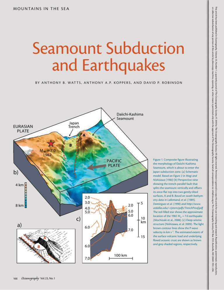
Seamount Subduction and Earthquakes B Y A N T H O N Y B . WAT T S , A N T H O N Y A . P. K O P P E R S , A N D D AV I D P. R O B I N S O N Daiichi-Kashima Seamount Japan Trench EURASIAN PLATE A B M w = 7.0 1982 PACIFIC PLATE b) 4 km 2.0 3.0 4.0 5.0 8 km 2.0 5.0 6.0 c) a) 6.0 15 6.0 7.0 166 Oceanography Vol.23, No.1 10 km 7.0 A B 5 100 km Figure 1. Composite figure illustrating the morphology of Daiichi-Kashima Seamount, which is about to enter the Japan subduction zone. (a) Schematic model. Based on Figure 2 in Mogi and Nishizawa (1980) (b) Perspective view showing the trench-parallel fault that splits the seamount vertically and offsets its once-flat top into two gently tilted surfaces, A and B. Based on swath bathymetry data in Lallemand, et al. (1989), Dominguez et al. (1998) and http://www. utdallas.edu/~rjstern/pdfs/TrenchProof.pdf The red-filled star shows the approximate location of the 1982 Mw = 7.0 earthquake (Mochizuki et al., 2008). (c) Deep seismic structure (Nishizawa, et al. 2009). The light brown contour lines show the P-wave velocity in km s -1. The estimated extent of the surface volcanic load and underlying flexed oceanic crust are shown as brown and grey shaded regions, respectively. This article has been published in Oceanography, Volume 23, Number 1, a quarterly journal of The Oceanography Society. © 2010 by The Oceanography Society. All rights reserved. Permission is granted to copy this article for use in teaching and research. Republication, systemmatic reproduction, or collective redistirbution of any portion of this article by photocopy machine, reposting, or other means is permitted only with the approval of The Oceanography Society. Send all correspondence to: info@tos.org or Th e Oceanography Society, PO Box 1931, Rockville, MD 20849-1931, USA. M O U N TA I N S I N T H E S E A ABSTR ACT. Seamounts are ubiquitous features of the seafloor that form part of the fabric of oceanic crust. When a seamount enters a subduction zone, it has a major affect on forearc morphology, the uplift history of the island arc, and the structure of the downgoing slab. It is not known, however, what controls whether a seamount is accreted to the forearc or carried down into the subduction zone and recycled into the deep mantle. Of societal interest is the role seamounts play in geohazards, in particular, the generation of large earthquakes. INTRODUCTION The seafloor is littered with seamounts, most of which are small (Hillier and Watts, 2007). Satellite-derived gravity anomaly data, however, suggest that there maybe as many as 12,000 large seamounts that rise > 1.5 km above the depth of the surrounding seafloor (Wessel et al., 2010). Irrespective of whether these seamounts are growing up during their volcanic construction or are sinking, once they become inactive, they are being carried along by plate motions and will eventually be subducted (Staudigel and Clague, 2010). Indeed, there are many present-day examples of seamounts that are in the throes of being subducted. Niue Seamount (DuBois et al., 1975) in the Southwest Pacific Ocean, and Christmas Seamount (Woodroffe et al., 1990) in the Indian Ocean, for example, are being uplifted as they ride the flexural bulge seaward of the Tonga and JavaSumatra trenches. Osbourn (Lonsdale, 1986) and Bourgainville (DuBois et al., 1988) in the Southwest Pacific Ocean are seamounts that have been tilted a few degrees as they move downslope toward the Tonga-Kermadec and New Hebrides trench axes. Finally, Erimo and DaiichiKashima (Nishizawa et al., 2009) in the West Pacific Ocean are presently located in the Japan trench axis. Once a seamount enters a subduction zone, it would be expected to profoundly affect the morphology, structure, and vertical motion history of the forearc region between the trench axis and the volcanic arc. Seamount subduction may also influence the degree of coupling between the overriding and subducting plates and may affect the seismicity, especially the size and frequency of large earthquakes (Kelleher and McCann, 1976). Recently, Nishizawa et al. (2009) and Das and Watts (2009) demonstrated that seamounts play a major role in controlling the rupture history of large earthquakes, in particular, acting as either barriers (e.g., Kodaira et al., 2000) or as asperities (e.g., Husen et al., 2002) to earthquakes. A subducted seamount may prevent earthquakes from proceeding or propagating through an area. Such a barrier could have either very high friction, high enough to prevent the earthquake proceeding, or low friction. In the case of low friction, the area does not store significant stress during the interseismic period, as stress is released aseismically or in small earthquakes. The absence of stress results in prevention of earthquake propagation. An asperity is an area with locally increased friction. Typically, due to the increased friction, an asperity exhibits a reduced amount of interseismic aseismic slip relative to the surrounding regions and hence will slip an increased amount during an earthquake. It is unknown, however, if the resulting increased surface roughness acts to locally increase friction in the vicinity of a subducted seamount or if the increased presence of subducted fluids acts to locally reduce it. In this paper, we briefly discuss the shape and structure of subducted seamounts, what controls whether they are accreted or subducted, and the links that might exist between seamounts and the rupture history of large subduction zone earthquakes. SHAPE AND STRUCTURE OF SEAMOUNTS NEAR TRENCHES Shipboard bathymetry profiles show that seamounts about to enter Pacific subduction zones range in height from 1–5 km, have widths from 20–100 km, and have both pointed and gently curved or flat tops. Surveys of Daiichi-Kashima Seamount at the southern end of the Japan trench (Mogi and Nishizawa, 1980) show that it is bisected by a steep, trench-parallel normal fault that has vertically offset its flat top by ~ 1.5 km (Figure 1). Similar-trending faults have been reported from other seamounts in the vicinity of the Mariana-Izu Bonin trenches (Fryer and Smoot, 1985) and Tonga-Kermadec trench (Coulbourn et al., 1989). Only a few deep seismic studies of trench seamounts exist, but recent surveys over Daiichi-Kashima (Nishizawa et al., 2009) and the Louisville Ridge (Contreras-Reyes et al., 2010) show these seamounts are underlain by thickened crust. Moreover, P-wave velocity contours are elevated, suggesting that these seamounts have relatively dense cores and that the underlying flexed crust may have been intruded by magmatic material. Oceanography March 2010 167 FOREARCS AND BURIED SEAMOUNTS Many forearcs comprise a thick sequence of highly deformed sediment (the so-called accretionary wedge) that has been scraped off the subducting plate and structurally deformed by folding and thrusting. Others, however, have less sediment, and the depth to the crystalline basement is relatively shallow. A good example of a subducted seamount is Muroto in the Nankai accretionary wedge offshore Southwest Japan. Seismic data show that this seamount is ~ 50-km wide at its base, ~ 25-km wide at its top and 4-km high, and is underlain by flexed oceanic crust (Kodaira, et al., 2000). Other forearcs where seamounts have been imaged include Mediterranean Ridge (von Huene et al., 1997), Cascadia (Wells et al., 2009), and Mariana (Oakley et al., 2007, 2008). The Mediterranean Ridge and Cascadia seamounts are marked by gravity and magnetic anomaly highs. However, similar data over the seamounts in the Mariana forearc are associated with lows. Dredge haul and Ocean Drilling Program core samples show that these seamounts comprise serpentinites (see Spotlight 9 on page 174 of this issue [Wheat et al., 2010]) and other rock types, including muds, that have flowed out onto the forearc sediments. Geochemical sampling of these muds suggest that the serpentinite protoliths might be basalts that formed on or near a mid-ocean ridge and therefore that these seamounts may have been altered Anthony B. Watts (tony@earth. ox.ac.uk) is Professor of Marine Geology and Geophysics, Department of Earth Sciences, University of Oxford, Oxford, UK. Anthony A.P. Koppers is Associate Professor, College of Oceanic & Atmospheric Sciences, Oregon State University, Corvallis, OR, USA. David P. Robinson is Postdoctoral Researcher, Department of Earth Sciences, University of Oxford, Oxford, UK. Quepos Earthquake Mw = 6.9, 1999 Nicoya Earthquake Mw = 7.0, 1990 30 km prior to entering the subduction zone. Perhaps the most striking manifestation of seamount subduction is seen in swath bathymetry data. These data at the Costa Rica margin show mass-wasting features such as head scars, slumps, and slides that align with seamounts on the subducting Cocos Plate (Figure 2). CONTINENTAL SHELF NORTH AMERICAN PLATE N SCARS SCAR TRENCH Fisher Seamount SEAMOUNTS Quepos Plateau COCOS PLATE Figure 2. Perspective view of the Costa Rica margin showing the morphology of the subducting Cocos oceanic plate and the overriding North American Plate, constructed using swath bathymetry data acquired onboard MV Sonne. Seamounts on the subducting plate align with landslide scars on the overriding plate, suggesting that subducting seamounts are able to “plow through” the forearc and generate large-scale slumps and slides. The red-filled stars show the projected locations of 1990 Mw = 7.0 and 1999 Mw = 6.9 earthquakes (Bilek et al., 2003). Based on von Huene et al. (2000) 168 Oceanography Vol.23, No.1 In addition to modifying the upper shallow part of the forearc, seamount subduction may modify its lower deep part (Dominguez et al., 1998). For example, it may cause tectonic erosion, steepening any overlying thrusts and folds and releasing sediments and fluids into the underlying subduction zone (Bangs et al., 2006), and it may modify the subsidence and uplift history of a forearc (Lallemand and Le Pichon, 1987; Lallemand et al., 1989; Dominguez et al., 1998; Oakley et al., 2008). A seamount chain, rather than an isolated seamount, might induce a “deformation wave” that alternately inflates and deflates a forearc as the seamounts are progressively carried into the subduction zone by plate motion (Laursen et al., 2002). THE MECHANICS OF SEAMOUNT SUBDUCTION But what actually happens to a seamount when it is subducted? In particular, what determines whether a seamount is broken up and accreted to the forearc or is carried into a subduction zone more or less intact? Several factors maybe involved. Thickness of the Subduction Channel Seismic images of the subduction channel off Ecuador (Sage et al., 2006) show a layer of poorly consolidated and intensively sheared sediment that has been dragged down by the subducting plate beneath the overriding plate. Cloos and Shreve (1996) suggest that it is the ratio of the relative thickness of the sediments within the channel to the height of a seamount that determines its fate. If the seamount is high relative to channel thickness, it might be decapitated at shallow depths (Figure 3a), whereas if it is low relative to channel thickness, it may be carried some distance and decapitated at greater depths when it jams up against the roof of the channel (Figure 3b). Relative Strength of the Subducting and Overriding Plates It has long been accepted that the negative buoyancy (i.e., sinking) of oceanic lithosphere initiates subduction (see Koppers and Watts, 2010). Although it is known that the strength of a subducting a) oceanic plate generally increases with age, the long-term rheological properties of the overriding plate are unknown. Many forearcs (e.g., Barbados) comprise an accretionary wedge that is assumed to be an intrinsically weak material. Subducted seamounts might therefore plow through the forearc, experiencing little or no deformation. Others (e.g., Cascadia), however, reveal a forearc with a distinct crystalline basement structure, which would be much stronger and offer more resistance, causing a subducted seamount to jam and possibly break up. SHALLOW DECAPITATION Forearc Thin Layer Sediment Thickening Subduction Channel Subducting Oceanic Crust TRUNCATED SEAMOUNT Trench Axis b) Thick Layer Sediment Forearc Thinning Subduction Channel Subducting Oceanic Crust Trench Axis DEEP DECAPITATION Figure 3. Schematic diagram illustrating the Cloos and Shreve (1996) model for seamount subduction. (a) Mariana-type case where a relatively large seamount is carried into a subduction zone with a relatively thin subduction channel. The seamount is truncated at relatively shallow depths and, hence, low confining pressures, so there is little or no seismicity. (b) Chilean-type case where a relatively small seamount is carried into a subduction zone with a relatively thick subduction channel. The seamount, in this case, is truncated at relatively deep depths and high confining pressures, which leads to seismicity. Oceanography March 2010 169 Internal Structure of Subducted Seamounts Seismic studies reveal that the volcanic edifice of a seamount builds up and out on a gently flexed, uniformly layered, oceanic crust. It is easy to envisage how such a structure would deform when it reaches a trench because the flexed layers of the edifice and underlying crust will be rotated and sheared as they enter a subduction zone. Deformation may be facilitated by the fact that the interface between the edifice and oceanic crust may already have acted as a décollement surface during volcano growth (Got et al., 2008). Some seamounts and oceanic islands, however, have complex internal structures with dense volcanic cores (e.g., Tenerife; Canales et al., 2000) and evidence of both upper (e.g., Daiichi-Kashima Seamount; Nishizawa et al., 2009) and lower (e.g., Louisville Ridge; ContrerasReyes et al., 2010) oceanic crustal Trench Axis Outer Rise a) Depth (km) 0 10 Subducting Oceanic Plate Overriding Plate Seamount Formed on a Strong Plate 20 Te = 25 km km 30 0 Depth (km) b) 200 Outer Rise 0 10 100 Subducting Oceanic Plate Overriding Plate Seamount Formed on a Weak Plate 20 Te = 5 km 30 Figure 4. Simple model for the crustal structure of two seamounts—one formed offridge and the other on-ridge—that are about to enter a subduction zone. (a) Off-ridge seamounts are more regionally compensated so that much of their support would have already been removed by subduction. These seamounts are therefore less buoyant (small orange arrow) and thus less well coupled to the forearc when they enter a subduction zone. (b) On-ridge seamounts are locally more compensated so that little of their support would have been removed. These seamounts are therefore more buoyant (large orange arrow) and thus better coupled to the forearc. 170 Oceanography Vol.23, No.1 intrusion. These structures would be much more difficult to accommodate in a subduction channel. Buoyancy of Subducted Seamounts Oceanic flexure studies show that seamounts are compensated differently at depth, depending on whether they formed on a weak plate near a midocean ridge or on a strong plate in a plate interior (see Koppers and Watts, 2010). As a result, seamounts will be in different states of crustal buoyancy as they enter trenches (Figure 4). For example, a seamount on a strong plate would be regionally supported and, hence, have had much of its compensation removed before its arrival at a trench. Because it is less buoyant, such a seamount would be less likely to lift up the forearc and, thus, more weakly coupled to the overriding plate. A seamount formed on a weak plate, however, is more locally compensated and so retains more of its buoyancy and is more likely to jam a subduction zone. SEAMOUNTS AND THE RUPTURE HISTORIES OF LARGE SUBDUCTION ZONE EARTHQUAKES It has been more 35 years since Kanamori (1971) first suggested that large earthquakes (i.e., Mw > 8.0) at convergent plate boundaries reflect the degree of coupling between the overriding and subducting plates. In his view, some arc systems were strongly coupled (e.g., Aleutian) and generated large earthquakes when they finally slipped, while others (e.g., Izu-Bonin and Mariana) were weakly coupled and large earthquakes were either rare or absent. Kelleher and McCann (1976) noted, however, that many arc-trench systems were highly segmented with regard to their seismicity. Some segments were active on historical time scales, while others were not (so-called “seismic gap”). Because the seafloor varies spatially in roughness, Kelleher and McCann (1976) suggested that there might be a link between large earthquakes and the morphology of the subducting oceanic plate. In particular, they noted that the size and frequency of large earthquakes were reduced in regions of thick oceanic crust where aseismic ridges and other “bathymetric highs” (i.e., seamount chains) were about to enter a subduction zone. Cloos (1993) argued that only the thickest continental “blocks” (30 km and thicker) would be buoyant enough to resist subduction. However, Cloos and Shreve (1996) pointed out that large seamounts could be subducted to great enough depths to cause an earthquake if the sediment in the subduction channel is sufficiently thick (Figure 4). In such a case, subducted seamounts act as a strong asperity (or sticking point), such that the fault ruptures sporadically when frictional resistance is overcome. Scholz and Small (1997) reconsidered the role played by subducted seamounts in coupled and uncoupled and well and poorly sedimented arc-trench systems. For coupled arcs (e.g., Aleutian), they argue that a large seamount would increase the coupling between the subducting and overriding plates even more due its buoyancy. For decoupled arcs (e.g., Izu-Bonin and Mariana), a large seamount would only increase the coupling locally. The Tonga-Kermadec trench is a decoupled arc with very little sediment in the subduction channel that is intersected at 26°S by the Louisville Ridge seamount chain. The intersection is characterized by a shoaling of the trench and a ~ 170-km-long seismic gap. The gap has been interpreted as a locally well-coupled zone that is seismically locked and is of sufficient length to generate an Mw > 8.0 earthquake in the future when it slips (Scholz and Small, 1997). Indeed, several great earthquakes have already occurred along other parts of the Tonga-Kermadec arc. Since 2000, there has been a rapid increase in our knowledge of the rupture history of large subduction zone earthquakes, the deep seismic structure of forearc overriding plates, and the morphology of subducting oceanic plates. Kodaira et al. (2000) used an integrated data set of earthquake aftershock relocations, seismic refraction, and swath bathymetry data to suggest that seamounts acted as a barrier to the rupture zone that generated the 1946 Mw = 8.2 Nankai earthquake, while Husen et al. (2002) suggested that seamounts acted as an asperity during the 1990 Mw = 7 Gulf of Nicoya earthquake. Bilek et al. (2003) studied the rupture history of three large subduction zone earthquakes at the Costa Rica margin where both seismic and swath bathymetry surveys have been carried out. They showed that the epicenters of the 1990 Mw = 7.0 Gulf of Nicoya and the 1999 Mw = 6.9 Quepos earthquakes line up with the Fisher Seamount and the Quepos Plateau on the subducting Cocos oceanic plate (Figure 2). Both earthquakes had a relatively simple rupture history and Bilek et al. (2003) suggest that because of the limited extent of the aftershocks, bathymetric features on the subducting plate acted as an asperity during the rupture. The degree of coupling between the overriding and subducting plates may not always be strong over a seamount, even if it is locally compensated and buoyant. Mochizuki et al. (2008) studied a large earthquake (1982, Mw = 7) in the Japan forearc where an active-source seismic experiment revealed a subducted seamount at a depth of ~ 10 km. Mochizuki et al. (2008) found, however, only a few aftershocks at depths corresponding to the top of the seamount, suggesting weak coupling between the subducting and overriding plates. They attributed the weak coupling in what is otherwise a strongly coupled arc system to tectonic erosion that resulted in a transfer of fluids from the forearc into the underlying subduction channel, thereby lubricating and weakening the contact surface between the seamount and the overriding plate. Recently, Das and Watts (2009) reviewed the rupture histories of the 1986 Mw = 8.0 Andreanof Island, Alaska, and the 2001 Mw = 8.4 Arequipa, southern Peru, earthquakes. These earthquakes ruptured 28,000 and 60,000 km2 areas of the forearc from shallow depths to depths of ~ 45 km and 35–40 km, respectively (Das and Kostrov, 1990; Robinson et al., 2006). In the Andreanof Island earthquake, high-slip areas within the rupture surface line up with relative plate motions and with a cluster of small seamounts on the subducting Pacific oceanic plate (Figure 5). In southern Peru, however, seamounts on the subducting Nazca Plate appear to have acted as a barrier that held up the earthquake for some 18 seconds. Oceanography March 2010 171 54 EURASIAN PLATE Bering Sea Aleutian Islands 52 Andreanof Earthquake Mw = 8.0, 1986 TRE l Paralle Trenchraphy (m) g o p o T 800 NCH 0 -800 50 Seamounts PACIFIC PLATE Seismic Slip Intensity 0.0 0.8 1.6 2.4 3.2 4.0 4.8 Amelia Fracture Zone 6.0 48 -178 -176 -174 -172 -170 Figure 5. The final slip distribution of the 1986 Mw = 8.0 Andreanof Islands, Alaska, earthquake superimposed on a shaded relief GEBCO bathymetry map. Based on Das and Kostrov (1990) and Das and Watts (2009). The red-filled star shows the region where the rupture initiated. The arrow shows the convergence direction between the Pacific and Eurasian plates. The solid black lines show the bathymetry along a trench-parallel profile constructed from the GEBCO grid. The figure shows that the region of highest slip during the earthquake aligns with a number of small seamounts that rise up to ~ 800 m above the depth of the surrounding seafloor. be subducted at the ends of their life cycles. The hundreds of thousands of seamounts still riding the plates today will eventually enter subduction zones, where they will be deformed and may be destroyed. The small number of studies that have been carried out thus far suggest that seamount subduction is an important geological process that affects the morphology, structure, and verticalmotion history of subduction zones and, most notably, the rupture history of large earthquakes. Future work should focus on more swath bathymetry mapping and better seismic imaging of the deep structure of seamounts on the subducting plate and in the forearc region. Field mapping, not only of subducted, but obducted seamounts (e.g., central Oman; Searle, 1983) in mountain belts, would also be useful in order to better understand the internal structure of seamounts. We also need more accurate slip measurements, better aftershock locations, and rupture histories of large earthquakes. Finally, we will require more analogue and numerical modeling studies of seamount subduction using realistic rheologies. ACKNOWLEDGEMENTS CONCLUSIONS AND FUTURE WORK This review suggests that seamount subduction is linked in some way with the seismicity of convergent plate boundaries. It is not presently clear, however, whether subducted seamounts cause or promote large earthquakes or simply hold them up until the next one occurs. Here, we have mainly been considering the subduction of isolated 172 Oceanography Vol.23, No.1 seamounts, but it is interesting to speculate on the effect of a seamount chain. A chain could potentially decouple one segment of a forearc (on one side of the chain) from another. Also, seamount chains that form a continuous feature across the seismogenic layer have the potential to severely restrict the spatial extent of the slip plane, preventing any rupture across them. It is inevitable that seamounts will We thank Shamita Das for providing the total slip data for the Andreanof Island earthquake. We also thank Roland von Huene and Hubert Staudigel for detailed and very useful reviews of an early version of this paper. AAPK was supported by the National Science Foundation through the SBN Research Coordination Network (EF-0443337). DPR is supported by NERC award NE/C518806/1. REFERENCES Bangs, N.L.B., S.P.S. Gulick, and T.H. Shipley. 2006. Seamount subduction erosion in the Nankai Trough and its potential impact on the seismogenic zone. Geology 34:701–704. Bilek, S.L., S.Y. Schwartz, and H.R. DeShon. 2003. Control of seafloor roughness on earthquake rupture behavior. Geological Society of America Bulletin 31:455–458. Canales, J.P., J.J. Danobeitia, and A.B. Watts. 2000. Wide-angle seismic constraints on the internal structure of Tenerife, Canary Islands. Journal of Volcanology and Geothermal Research 103:65–81. Cloos, M. 1993. Lithospheric buoyancy and collisional orogenesis: Subduction of oceanic plateaus, continental margins, island arcs, spreading ridges, and seamounts. Geological Society of America Bulletin 105:715–737. Cloos, M., and R.L. Shreve. 1996. Shear-zone thickness and the seismicity of Chileanand Marianas-type subduction zones. Geology 24:107–110. Contreras-Reyes, E., I. Grevemeyer, A.B. Watts, L. Planert, E.R. Flueh, and C. Peirce. 2010. Crustal intrusion beneath the Louisville hotspot track. Earth and Planetary Science Letters 289:323–333. Coulbourn, W.T., P.J. Hill, and D.D. Bergersen. 1989. Machias seamount, Western Samoa: Sediment remobilization, tectonic dismemberment and subduction of a guyot. Geo-Marine Letters 9:119–125. Das, S., and B.V. Kostrov. 1990. Inversion for seismic slip rate history and distribution with stabilizing constraints: Application to the 1986 Andreanof Islands earthquake. Journal of Geophysical Research 95:6,899–6,913. Das, S., and A.B. Watts. 2009. Effect of subducting seafloor topography on the rupture characteristics of great subduction zone earthquakes. Pp. 103–118 in Subduction Zone Geodynamics. S. Lallemand and F. Funiceillo, eds, SpringerVerlag, Berlin-Heidelberg. Dominguez, S., S.E. Lallemand, J. Malavieille, and R. von Huene. 1998. Upper plate deformation associated with seamount subduction. Tectonophysics 293:207–224. DuBois, J., C. Deplus, M. Diament, J. Daniel, and J.-Y. Collot. 1988. Subduction of the Bougainville seamount (Vanuatu): Mechanical and geodynamic implications. Tectonophysics 149:111–119. DuBois, J., J. Launay, and J. Recy. 1975. Some new evidence on lithospheric bulges close to island arcs. Tectonophysics 26:189–196. Fryer, P., and N.C. Smoot. 1985. Processes of seamount subduction in the Mariana and Izu-Bonin trenches. Marine Geology 64:77–90. Got, J.-L., V. Monteiller, J. Monteux, R. Hassani, and P. Okubo. 2008. Deformation and rupture of oceanic crust may control growth of Hawaiian volcanoes. Nature 451:453–456. Hillier, J.K., and A.B. Watts. 2007. Global distribution of seamounts from ship-track bathymetry data. Geophysical Research Letters 34, L13304, doi:10.1029/2007GL029874. Husen, S., E. Kissling, and R. Quintero. 2002. Tomographic evidence for a subducted seamount beneath the Gulf of Nicoya, Costa Rica: The cause of the 1990 Mw = 7.0 Gulf of Nicoya earthquake. Geophysical Research Letters 29, 8, doi:10.1029/2001GL014045. Kanamori, H. 1971. Great earthquakes at island arcs and the lithosphere. Tectonophysics 12:187–198. Kelleher, J., and W. McCann. 1976. Buoyant zones, great earthquakes, and some predictions. Journal of Geophysical Research 81:4,885–4,896. Kodaira, S., N. Takahashi, A. Nakanishi, S. Miura, and Y. Kaneda. 2000. Subducted seamount imaged in the rupture zone of the 1946 Nankaido earthquake. Science 289:104–106. Koppers, A.A.P., and A.B. Watts. 2010. Intraplate seamounts as a window into deep Earth processes. Oceanography 23(1):42–57. Lallemand, S., R. Culotta, and R. von Huene. 1989. Subduction of the Daiichi Kashima seamount in the Japan trench. Tectonophysics 160:231–247. Lallemand, S., and X. Le Pichon. 1987. The Coulomb wedge model applied to the subduction of seamounts in the Japan trench. Geology 15:1,065–1,069. Laursen, J., D.W. Scholl, and R. von Huene. 2002. Neotectonic deformation of the central Chile margin: Deepwater forearc basin formation in response to hot spot ridge and seamount subduction. Tectonics 21, doi:10.1029/2001TC901023. Lonsdale, P. 1986. A multibeam reconnaissance of the Tonga trench axis and its intersection with the Louisville guyot chain. Marine Geophysical Researches 8:295–327. Mochizuki, K., T. Yamada, M. Shinohara, Y. Yamanaka, and T. Kanazawa. 2008. Weak interplate coupling by seamounts and repeating M~7 earthquakes. Science 321:1,194–1,197. Mogi, A., and K. Nishizawa. 1980. Breakdown of a seamount on the slope of the Japan Trench. Proceedings of the Japan Academy 56:257–259. Nishizawa, A., K. Kaneda, N. Watanabe, and M. Oikawa. 2009. Seismic structure of the subducting seamounts on the trench axis: Erimo Seamount and Daiichi-Kashima Seamount, northern and southern ends of the Japan trench. Earth, Planets, and Space 61:e5–e8. Oakley, A.J., B. Taylor, and G.F. Moore. 2008. Pacific Plate subduction beneath the central Mariana and Izu-Bonin forearcs: New insights from an old margin. Geochemistry, Geophysics, Geosystems 9, doi:10.1029/2007/GC001820. Oakley, A.J., B. Taylor, P. Fryer, G.F. Moore, A.M. Goodcliffe, and J.K. Morgan. 2007. Emplacement, growth, and gravitational deformation of serpentinite seamounts on the Mariana forearc. Geophysical Journal International doi:10.1111/j.1365-1246X. 2007.03451.x. Robinson, D.P., S. Das, and A.B. Watts. 2006. Earthquake rupture stalled by a subducting fracture zone. Science 312:1,203–1,205. Sage, F., J.-Y. Colot, and C.R. Ranero. 2006. Interplate patchiness and subduction-erosion mechanisms: Evidence from depth-migrated seismic images at the central Ecuador convergent margin. Geology 34:997–1,000. Scholz, C.H., and C. Small. 1997. The effect of seamount subduction on seismic coupling. Geology 25:487–490. Searle, M.P. 1983. Alkaline peridotite, pyroxenite, and gabbroic intrusions in the Oman mountains, Arabia. Canadian Journal of Earth Science 21:396–406. Staudigel, H., and D.A. Clague. 2010. The geological history of deep-sea volcanoes: Biosphere, hydrosphere, and lithosphere interactions. Oceanography 23(1):58–71. von Huene, R., C.R. Ranero, and W. Weinrebe. 2000. Quaternary convergent margin tectonics of Costa Rica, segmentation of the Cocos Plate, and central American volcanism. Tectonics 19:314–334. von Huene, R., T. Reston, N. Kukowski, G.A. Dehghani, W. Weinrebe, and the IMERSE Working Group. 1997. A subducting seamount beneath the Mediterranean Ridge. Tectonophysics 271:249–261. Wells, R.E., C.S. Weaver, and R.J. Blakely. 2009. Fore-arc migration in Cascadia and its neotectonic significance. Geology 26:759–762. Wessel, P., D.T. Sandwell, and S.-S. Kim. 2010. The global seamount census. Oceanography 23(1):24–33. Wheat, C.G., P. Fryer, K. Takai, and S. Hulme. 2010. Spotlight 9: South Chamarro Seamount. Oceanography 23(1):174–175. Woodroffe, C.D., R. McLean, H. Polach, and E. Wallensky. 1990. Sea level and coral atolls: Late Holocene emergence in the Indian Ocean. Geology 18:62–66. Oceanography March 2010 173
