Document 13182171
advertisement
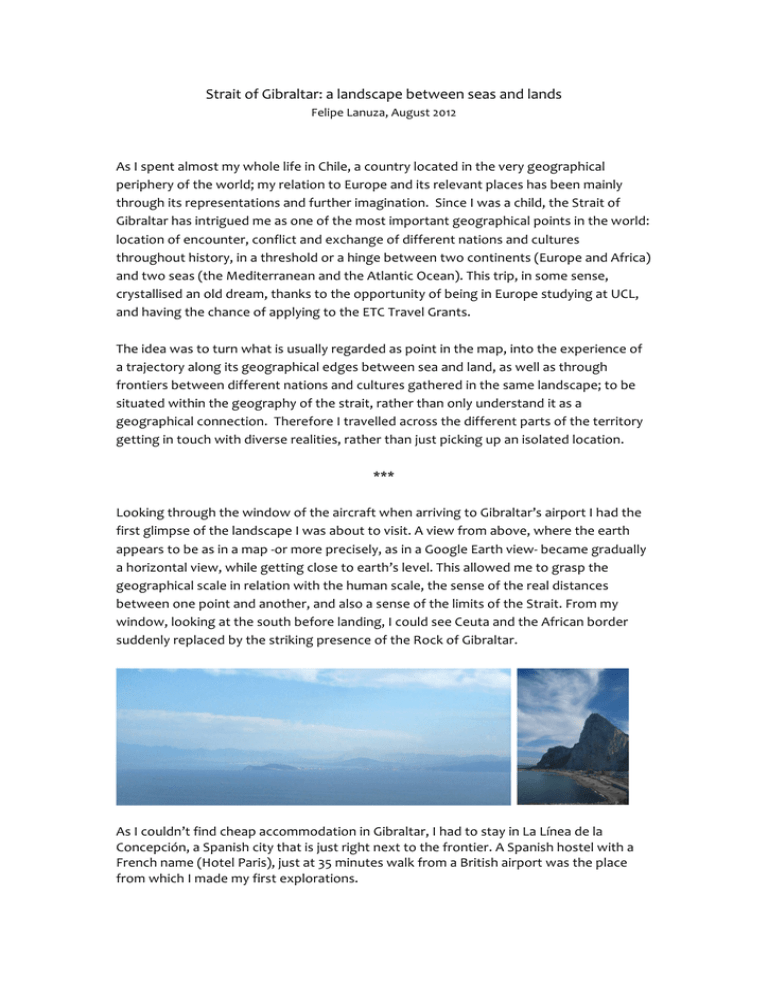
Strait of Gibraltar: a landscape between seas and lands Felipe Lanuza, August 2012 As I spent almost my whole life in Chile, a country located in the very geographical periphery of the world; my relation to Europe and its relevant places has been mainly through its representations and further imagination. Since I was a child, the Strait of Gibraltar has intrigued me as one of the most important geographical points in the world: location of encounter, conflict and exchange of different nations and cultures throughout history, in a threshold or a hinge between two continents (Europe and Africa) and two seas (the Mediterranean and the Atlantic Ocean). This trip, in some sense, crystallised an old dream, thanks to the opportunity of being in Europe studying at UCL, and having the chance of applying to the ETC Travel Grants. The idea was to turn what is usually regarded as point in the map, into the experience of a trajectory along its geographical edges between sea and land, as well as through frontiers between different nations and cultures gathered in the same landscape; to be situated within the geography of the strait, rather than only understand it as a geographical connection. Therefore I travelled across the different parts of the territory getting in touch with diverse realities, rather than just picking up an isolated location. *** Looking through the window of the aircraft when arriving to Gibraltar’s airport I had the first glimpse of the landscape I was about to visit. A view from above, where the earth appears to be as in a map -­‐or more precisely, as in a Google Earth view-­‐ became gradually a horizontal view, while getting close to earth’s level. This allowed me to grasp the geographical scale in relation with the human scale, the sense of the real distances between one point and another, and also a sense of the limits of the Strait. From my window, looking at the south before landing, I could see Ceuta and the African border suddenly replaced by the striking presence of the Rock of Gibraltar. As I couldn’t find cheap accommodation in Gibraltar, I had to stay in La Línea de la Concepción, a Spanish city that is just right next to the frontier. A Spanish hostel with a French name (Hotel Paris), just at 35 minutes walk from a British airport was the place from which I made my first explorations. This place provided me a view of an empty plot in the centre of this Spanish city, example of the levels of obsolescence of an important part of its urban infrastructure. I was delighted by this view on this void and the traces of former constructions, due to my fascination on ruins and urban leftovers. The presence of the Rock of Gibraltar is predominant, and concentrates the attention as a reference in the city and a reminder of former conflicts and tensions that have built up the history of the Strait. The Rock still appears as an impenetrable fortified site, as the Spanish could have seen it during the Great Siege in the XVIII century. From above, the strategic importance of the Rock in this geographical context becomes evident. It has a complete visual dominion on the surroundings. Although these days low clouds covered the whole strait, the views from the heights of Gibraltar were impressive. From the tunnels built by British troops more than 200 years ago it was possible to look back at the Spanish positions. The airport and the cemetery seem to replicate the buffer zone between these conflicting armies. Sadly, I couldn’t see the African coastline from there due to the low cloud cover. The Rock is covered by dense vegetation, a true forest that hosts the only existing European monkeys, which have no problem in approaching tourists looking for food. But they look sad; it looks like the intense contact with people has altered their natural environment. Gibraltar and La Línea are separated by just a frontier, and loads of tourists and Spanish workers enter everyday. Less British people cross to the other side. In Gibraltar, one can go either in Spanish or in English, but as the majority of the people who deal with you are from Spain, then I ended up speaking in my first language first. I would even say English is almost not needed. Gibraltar, as a city, combines British and Spanish, even some Arab features. A good way of understanding this overlapping of cultures -­‐along the whole trip-­‐ was to listen to the radio in the car. You can either listen to a British radio talk show in Morocco or to chants of the verses of the Coran in La Línea. Renting a car also allowed me to cover more places in less time, for I had to reduce my trip a couple of days and I wanted to stick to the original plans as much as possible. After Gibraltar and La Línea I went to the West along the southern coast of Spain, staying in Algeciras, Tarifa and Barbate, visiting also some places and towns in between such as Pelayo, la Paloma, Zahara de los Atunes and Bolonia, among others. I saw a lot of contrasts, while Algeciras is a harbour; Tarifa has a strong historic and touristic character. There I visited the most southern accessible point of Europe, which marks the encounter of the Mediterranean Sea and the Atlantic Ocean. I had to walk against a furious wind to reach that point, which is just before a sort of a small island, surprisingly not a touristic spot, but a prison for illegal immigrants. The clouds cleared a bit this time and the Moroccan coast was now scarcely visible from the historic centre of Tarifa, which is a Medina, the traditional Arab urban form, built during the Muslim occupation. But what captured my attention were the simple and beautiful wooden barriers built in the beach to prevent the sand of being pushed into the city by the wind. I drove until the Trafalgar Cape, stretching a bit the trip to reach another remarkable historic site. The overwhelming presence of windmills in the landscape close to Tarifa confirmed me that the wind was not only a matter of these days but a very frequent phenomenon (viento de Levante). I also came across a Roman archaeological site (Baela Claudio), close to the village of Bolonia, so I took the chance to visit more ruins and to learn a bit more about the different historical stages of the Strait… I reserved the ferry ticket for crossing from Algeciras to Ceuta at sunset time; I thought it could give a beautiful image of the Algeciras Bay, the Rock of Gibraltar and the arrival to the Spanish city of Ceuta. Another weird crossing within this zone: going from one continent to another, but without getting out the country. The start of this journey was actually spectacular, but by the arrival to Ceuta it was already dark (and foggy, of course). Ceuta is similar to Gibraltar in various ways. Geographically, it is a city almost covering a peninsula, and it is a strategic point of control on the strait, perhaps more before than now. Not having such a radical topography as Gibraltar, Ceuta rather covers a bit more area of the African continent. In turn, this was also strongly resisted by Morocco. Ceuta is actually a beautiful city, with a predominant presence of Spanish but also a lot of people from Morocco and other countries. As Gibraltar and Tangier, it is a place that alternated different occupancies throughout history. I walked through the intricate streets of the city and also along its borders, looking at the nearby Moroccan city of Fnideq to the south and to Gibraltar and the Spanish Mediterranean coast to the north. It was still foggy and I got a bit frustrated, but came across a series of paintings along one of the main streets of Ceuta, which depicted the landscape as seen from different points of the strait. Even in the site, I looked at representations of reality in order to understand better my situation in that place. I also had the chance of visiting a huge castle that was built in the Middle Ages as a barrier to block the access to the peninsula from the inlands, and a new set of buildings by Portuguese architect Alvaro Siza, carefully integrated in the network of the old streets of the city. Although the whole area of the Strait is a sort of overlapping of different languages, architectures and people, which at the end makes it a bit similar in some sense, the experience in Morocco was noticeable different from the European part of the strait. Just a silly example to illustrate this: while in Tarifa girls do topless in the beach, one can scarcely find a local woman in a Moroccan beach. The few I saw were completely covered in black clothes. This is noticeable if we consider that the shortest distance between Tarifa and the African coast is 15km, just the same distance from Tower Bridge to Wembley Stadium, in London. I stayed the rest of the trip in the amazing city of Tangier, but again hired a car for a couple of days in order to visit some towns along the northern coast of Morocco. The driving experience was not as terrible as I expected -­‐Moroccans are famous for being dangerous drivers, fact that I early confirmed when taking a taxi from the frontier to the Hotel-­‐ and gave me autonomy to visit different places. Visiting an Islamic country during the Ramadan added a plus to the already exciting and incredible experience of the city. As a part of their religious tradition, during a month they do not eat during the day until 7pm. At that time they have a ‘Ramadan Breakfast’, which I tried to eat with the ‘slight’ difference of having eaten normally the whole day… couldn’t make it! This breakfast may explain the intense activity of the city until late night, which contrasted with the quiet day, where only the markets and the Medina and its surroundings were crowded and noisy. People in the streets of Tangier are very friendly. They usually speak three, four or even five different languages, which demonstrates a culture strongly determined by trade and international influence. Although they sometimes insist a bit too much in trying to sell you things or to guide you through the city, there is no reason of being afraid because they are honest, reliable, and always willing to help. The old Islamic Medina of Tangier is a complex network of narrow streets full of surprising corners and views over the sea and the bay, whereas the modern city has a sort of Western shape, but filled with a different content, more chaotic, livelier, and more unpredictable. The city offers a myriad of attractions of different kinds and I tried to do the most of it, going to the Medina Museum, Café Hafa, the beach, etc. The best view over the strait and the Spanish coast was from the ancient Phoenician tombs nearby the Medina. Fortunately, this was a clear sky day and I enjoyed a beautiful sightseeing, along with local people who use this place for silent contemplation and meditation. I went to the small city of Ksar el Seghir, a small town by the sea, where I managed to enter another archaeological site (more ruins!), which was supposedly closed to the public. In Morocco, apparently regulations (and prizes) are not so strict, giving room to conversations and negotiations to get access to some places or to better deals. Along this trip I stopped in other small villages, but they were predominantly fancy private isolated villas looking at the sea. I also followed the advice of going to see Assilah, a Unesco heritage site, located at 35km of Tangier, but going to the south. This small deviation was worth it in the sense of discovering a very beautiful settlement, but perhaps too cosmetic and tourist-­‐oriented. In this sense, the Medina of Tangier seemed more authentic and exciting. A walk through the streets of the rest of the city (clearly out of the heritage zone) gave me a more complete idea of how Assilah really was, poorer, generic and livelier Cap Spartel and the famous (but less impressive) Hercules caves, in the northeast corner of the African continent, were the places that I visited at the end, covering the last stage of the trip. Perhaps the view of the sunset in the Atlantic and some beach football is the most remarkable ending image, or at least what I want to keep as a final memory. In comparison with the relatively stable and homogeneous Chilean culture, and the large distances that separate different peoples in South America, the rich diversity concentrated in very few square kilometres was perhaps the most remarkable difference that I experienced. Although London -­‐my current city of residence-­‐ is a cosmopolitan city and has long history, the sense of passing from one country to another and from one culture to another surrounding the strait, gave me a different dimension of cultural diversity and time: one that is organized by geography. When I started studying architecture, drawing was regarded as one of the ways of capturing and understanding reality. I tried to recover this practice during the trip, but just made a few sketches that showed me how out of practice I was. But beyond this, what I appreciated of drawing was the quiet moments of silence to stop, observe and, in some sense, reconstruct on a sheet of paper what I was looking at, what was in front of me. Now I think on the pen tracing lines on the paper as a little metaphor of this trip. I walked a lot, and I also drove a lot. The Strait of Gibraltar, in my experience, is neither a point to pass through nor to stay for a while. It is an intense, weird, diverse, exciting and enhancing way of reconstructing a landscape by travelling along its limits. * Reconstruction of a satellite vision of the Strait of Gibraltar made out of partial aerial views of Google Earth. A way of planning a trip and visualizing it back on the map.
