UPPER MURRUMBIDGEE WATERWATCH The highs and lows of the Queanbeyan River
Volume 16 Issue 1
Summer 2013
UPPER MURRUMBIDGEE
WATERWATCH
The highs and lows of the Queanbeyan River
Events in the Queanbeyan River catchment over the Australia Day long weekend and in the weeks that followed, demonstrated the power of an informed and active community.
The Australia Day evening, a downpour of 75mm in an hour at the Googong development, caused a containment dam wall to breach sending muddy water down the local creek and into the
Queanbeyan River. Residents of Wickerslack
Lane, who live directly downstream of the development, woke on the Sunday morning to discover their pristine river was the colour of milky coffee!
One of the residents, Sue Gibson, has lived on the banks of the Queanbeyan for 45 years. She and her husband have raised their kids there where they have always bathed, brushed teeth and washed clothes with water directly pumped from the river. Waterwatch and Molonglo
Catchment Group staff went out to Sue’s place four days after the event and were disappointed to see the river still in a terrible state. Turbidity was reading at >200NTU and
Total Phosphate levels were also high (the latter is not surprising given that Phosphate in the soil is made available though disturbance and is then washed into our waterways).
What is also concerning is that this stretch of the
Queanbeyan River is a known spot for Platypus.
Such heavy sediment can kill off smaller organisms that the Platypus rely on for food.
Enough about the lows - what about the highs?!
Well the community swung into action and there has been a lot of positive results: and the Molonglo Catchment Group both featuring on the front pages of the Queanbeyan
Age and The Queanbeyan Chronicle; the Queanbeyan City Council, who is the regulatory body, about the incident in order to get some answers; water quality monitoring occurs on this stretch of the river so some of the members of
Wickerslack Lane are now our newest
Waterwatchers. with the Googong developers, CIC, and it is hoped that a Bush on the Boundary (BoB)
Group will be formed to help manage the increasing pressures that invariably come with the urban-bushland interface (for more information on the BoB initiative see: www.consact.org.au/projects/bush-on-theboundary)
So while there is no doubt that this is an unfortunate event that should never have happened, the developers will now work more carefully to ensure that proper onsite mitigation is implemented. This is what Waterwatch is all about - the community displaying the vigilance and energy needed to achieve a better result for the environment.
1
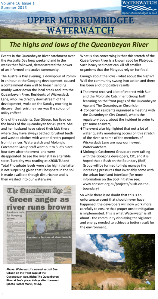
Above: Waterwatch’s newest recruit Sue
Gibson on the front page of the
Queanbeyan Age. Right: The Queanbeyan
River at Sue’s place, 4 days after the event
(photo Rachel Marks, MCG).
Volume 16 Issue 1
Summer 2013
From the Lilypad
(need a lilypad image for background)
FROM THE LILY PAD
28th April—QAQC
Thanks to all those who came along to QAQC way back in October. We had a beautiful day out at
Black Mountain Penninsula with a public stand as well the usual QAQC set-up. The event coincided with the weekend of Eid al-Adha, so there were plenty of small children, in their holiday best, in the park and surrounding the water bug trays.
The next QAQC will occur on the 28th April and will be at two locations in order to accommodate our ever increasing and wide-spread volunteer
QAQC at Black
Mtn Peninsula base.
WHAT TO BRING : Please bring your bottles for calibration refills and we’ll have a supply of batteries for your relevant instruments . BUT WAIT THERE’S MORE! We have just invested in flash, new Nitrate kits for all our Waterwatchers and we’ll be distributing them and training you in how to use these also. This will enable us to get Total Nitrogen readings at a finer scale which is important for getting a better picture of catchment health. Read more about Nitrates below.
WHERE: Sunday 28 April 2013.
1.
10:00am—Scottsdale reserve, south of Bredbo. Morning tea provided.
2. 2:00pm - Scout Hall—cnr Valley Ave and Gundaroo Dr, Gungahlin. Afternoon tea provided.
RSVP to Woo O’Reilly 6207 2246 or waterwatch@act.gov.au so we know how many cakes to bake!
Why are we measuring Nitrates??
Total Nitrogen takes on many forms. Nitrate (NO
3
-
) and Ammonia (NH
4
+
), the two soluble forms of nitrogen, are most easily released into aquatic systems. Nitrates are more abundant in the system and so by measuring them (with our new kits!) we are getting a good indication of the Total
Nitrogen present. Nitrates and ammonia can be released into aquatic systems from both point and diffuse sources. The main point sources are:
seepage and waste water from intensive livestock operation
(dairies, shearing sheds) and aquiculture operations;
municipal and industrial sewage works; and
runoff from waste disposal sites and gross pollution traps.
The common diffuse sources include:
Nitrogen that gets collected by specialised cyanobacteria as well as the nodules in crops such as legumes & pulses. This build up of Nitrates and Ammonia then get released into the soil or aquatic system;
runoff from animal manure or inorganic fertilizer; and
post burn-off/bush fire runoff.
In combination with Phosphorus, Nitrogen stimulates the growth of plant life. Nitrogen is important in the proteins, DNA and hormones that help plants, and later their consumers (like us!), grow and reproduce. Most hormones and all the DNA bases have quite high levels of Nitrogen. We need to measure Nitrates to know how much potential there is for rapid growth of the primary produces
(phytoplankton and aquatic plants) as this sets the balance in the system.
Total Nitrogen and Nitrates are measured in mg/L and the range should not exceed 15mg/L (ideally it would be more like 1mg/L). What happens if readings exceed this? With high Total Phosphorus, a little turbidity, high water temperature and low flow, this could lead to a cyanobacterial bloom
(blue-green algae) . Ammonia, in association with elevated water temperatures and pH, may lead to mortality in fish, frogs and turtles.
2
Volume 16 Issue 1
Summer 2013
MACRO MINUTES
FROM THE LILY PAD
The ‘Bug Team’ Wants YOU!!
Think the ‘A Team’ with out the Mohawk and jewellery, or the van and bad Eighties theme music. Ok—forget the
A Team analogy—I’m sure the Bug Team will make way more sense. Upper Murrumbidgee Waterwatch is looking for a new kind of volunteer— the kind that goes out for one or two days every six months to do a ‘bug blitz’ and ensures that we get adequate macro-invertebrate data across the region to feed into our Catchment
?
Health Indicator Program (CHIP).
While we stress that we are keen for our regular
Waterwatch volunteers to monitor bugs at their own site
?
(just have a go—we will help!), we need to get a minimum amount of data from the whole region and at present we are not getting this.
?
So, the plan is to have a couple of teams of three that can go out during April for the day, or half day, and do between 2 and six sites (depending on location) - one in each sub-catchment. One of the Waterwatch staff will come along at first but the hope is that by doing a intensive survey you will be come confidant enough by Spring to head out as a team with out us in tow.
If you are interested, give Woo O’Reilly a call or an email. She is putting the teams and itinerary together as we speak. Come out and see some new parts of the catchment—and collect some valuable data while you're at it. You’re guaranteed to catch more critters than the A Team— though you have to let them go in the end.
Contact Woo on 6207 2246 or waterwatch@act.gov.au
Look cool—yet warm—this Winter
As our lovely models can attest— the Waterwatch vests and Platypus Count t-shirts are the height of fashion.
While we mostly have um.. generous sizes left, there are still a few in S,M so be sure to ask your local Waterwatch coordinator for one of your very own.
And thanks to Martin and
Martine from Southern ACT
Catchment Group who have told Woo that they are available for modelling contracts. Woo, however, says she wants a finder’s fee.
3
Volume 16 Issue 1
Summer 2013
From the Lilypad
(need a lilypad image for background)
FROM THE LILY PAD
Working with the EPA - when and what to report
The Environment Protection Authority (EPA) in the ACT, works on minimising the damage we citizens can do to our environment. They have the job, along with numerous other duties, of overseeing the response to pollution incidents.
As part of our Waterwatching many of us come across incidents of one kind and another: weed outbreaks, illegal rubbish dumping, injury to wildlife, fires, algal population explosions and pollution. Only pollution is directly within the brief of the EPA.
In our waterways and their associated riparian areas we may encounter sudden rises in
Turbidity , with or without silt slugs, persistent drops in Dissolved Oxygen , out of the ordinary pH or EC readings or spikes in Phosphorus .
Erosion events and ‘chemical accidents’ are also polluting. Note that cyanobacterial and blanket-weed blooms are not pollution events, just the symptoms of earlier and probably on-going pollution.
When you encounter one of these events, especially pollution that you can trace back to a point source, and it is actually happening now, you should contact Canberra Connect
13 22 81 and ask to speak with an
Environment Protection Officer. This applies to a serious event and its immediate consequences. That officer will then contact you directly.
If you observe other pollutions events that may not be quite as urgent try and note as many details as possible and report the readings to your Waterwatch Coordinator and to the EPA at environment.protection@act.gov.au
You will get a reply.
You can assist the EPA by keeping an eye out around developments where you may encounter spikes in Turbidity or Phosphorus. Most moderate to large developments have silt trap ponds. The sediment collected is flocculated and the water is discharged regularly either as run-off or as dust suppressant. This means that silt dams should, under normal practice, be drawn down to about 20% of capacity.
This is very important when there are predicted rain fronts approaching.
If you notice a silt trap dam that has been standing full for more than three or four days, or is full and the weather is predicted to turn in the next day, you should notify the EPA. They will be grateful for your help, as they cannot have eyes everywhere. Remember, only contact the EPA officers for specific events, and be sure to keep your Waterwatch
Coordinator in the loop also.
With other events mentioned above such as rubbish dumping or weed outbreaks, again contact Canberra Connect - 13 22 81 and you will be put through to the relevant area. This is the most constructive path as calls need to be logged this way in order to keep track of them and ensure they get a response.
Waterwatch also plans to investigate the best path for reporting pollution incidents in NSW – watch this space!
4
COOMA CORRESPONDANCE
Upper Murrumbidgee Demonstration Reach - Riparian Project
Antia Brademann
The upper Murrumbidgee River corridor south of the ACT includes areas of wide, fertile, alluvial floodplains and open valleys with rolling hills to steep gorges with rocky cliffs. Being deeply incised in the landscape the upper
Murrumbidgee River valley provides a sheltered environment from the extremes of our tablelands climate including cold and drought and so is an important refuge in the landscape.
In the last century, however, the River has seen many changes which have impacted on its health. The open, fertile areas of the river corridor have been highly modified as a result of clearing and grazing, sand slugs have smothered the valley floor. Erosion has decreased water quality, altered seasonal flow cycles have reduced aquatic habitat and introduced species such as willows are taking hold. Yet despite this, the upper Murrumbidgee River corridor retains some intact areas of striking natural beauty.
Tempted? Come and join us on a paddling day.
Cooma Waterwatch, under the auspices of the
ACT government, is carrying out a project to survey the riparian zones along the upper
Murrumbidgee River corridor between the
Bredbo River confluence and the ACT border.
Riparian zones are the intermediate ecosystem between the river ecosystem and the rest of the landscape and are unique because they often contain assemblages of flora and fauna that are not found in the rest of the landscape. The role of riparian zones along a river highlight that river connectivity is an important aspect of a healthy river corridor. For example, riparian zones provide migration corridors, provide shelter and habitat, filter catchment run-off and provide a food source for the river ecosystem. For best effect it is important that these zones maintain their function along the whole stretch of the river corridor.
The project aims to identify riparian areas along the river corridor that are in good condition as well as get a picture of what factors may be causing condition decline in others. It is funded by the Murray Darling Basin Commission’s
Native Fish Strategy as part of the Upper
Murrumbidgee Demonstration Reach
(wwww.upperbidgee.reach.org.au) and is engaging Waterwatch volunteers, landholders and community members to apply the Rapid
Assessment of Riparian Condition (RARC) method as a survey tool. The RARC method is already used by Waterwatch volunteers as part of their monitoring activities but the number of survey sites in this project will mean a more complete picture of riparian health along the river can be gained. The RARC method is fast and easy to apply and allows repeat sampling in the future to monitor change over time. This also means that landholders that receive training as part of this project can use the method to support their own management activities in the future.
Areas not accessible by vehicle or on foot will be surveyed by volunteers paddling through certain river sections on several paddle days planned in the coming months. Apart from contributing their time to a very worthwhile project, paddle volunteers will be rewarded with experiencing some of the more pristine parts of the upper Murrumbidgee River that many don’t get to see.
If you would like to be involved with the project, either as a landholder or a volunteer please contact Antia Brademann on 6452 3178 or antia@coomawaterwatch.org.au
.
5
Volume 16 Issue 1
Summer 2013
STREAMLINES
Guise Creek runs from just above the Monaro
Highway when you come up out of Theodore, ambles across the shallow valley towards
Williamsdale from Royalla, and meets the
Murrumbidgee at Lobb’s Hole.
The chains of ponds above the highway are in open grassy box-gum woodland. On the other side of the road, where the solar farm is planned to be built, the creek has been incised by sheet erosion. This has been stabilised following some intervention by Southern ACT
Catchment Group and the local landholders in
2007. From there the creek travels south across pasture in former grassy box-gum woodland until it reaches the Gigerline Gorge escarpment west of Williamsdale. The creek then plunges into the gorge through scribbly gum- stringbark woodland and meets the river on a small floodplain dominated by one of the loveliest stands of manna gums in the region.
Guise Creek, just below the proposed solar farm, in 2007 before it was repaired.
Guise Creek
Stephen Skinner
In dry spells the creek trickles from pool to incised pool, and the plunge into the river is still. When the rains come, the wide valley quickly holds a raging torrent, but that is soon gone – another ‘flood & dry’ creek.
In September 2012, the ACT government approved the development of FRV Royalla
Solar Farm Pty Ltd . The concept of a solar farm in the gentle, exposed south-east facing slope at the top of the Guise Creek valley is to be commended. Solar farms make renewable energy with little if any greenhouse gas release once construction has been completed. With fewer than six rain days in any month in the area, the energy production should be more or less continuous. The disruption to the grass cover in the construction phase should be quickly repaired. Only a small part of the south-east corner of the block interacts with the creek line. With forethought and sensible planning the creekline that may need to be covered should be enhanced by the site levelling. The up-stream creek, across the highway, is in good condition.
The stream further down the valley is incised, has a history of erosion and deserves to be remediated as part of the development. It is up to the locals in the creek valley, and in nearby Royalla to make their expectations clear during the planning period.
If you would like to be the
Waterwatcher for Guise
(Guise’s seems redundant, or am I being very Crow-
Eaterish) Creek contact
Martin Lind at the Southern
ACT Catchment Group,
6296 6400 or waterwatch@sactcg.org.au
6
Volume 16 Issue 1
Summer 2013
TALES FROM THE SOUTH
Tuggeranong Lake Carers (TLC) Logo Competition
Tuggeranong Lake Carers (TLC) are running a competition to find a suitable logo for our new group.
We were formed to do something about the condition and health of Lake Tuggeranong, which over the last few years has been periodically closed to the public for months because of regular outbreaks of blue green algae. These outbreaks pose a serious health hazard.
We are working to raise community awareness about the issues, develop an overall Lake
Tuggeranong Management Catchment Plan, look at ways to reduce rubbish around the Lake and work to develop local wetlands to reduce nutrients and sedimentation that lead to the problem.
For further details, talk to the Southern
Waterwatch coordinator, Martin Lind, .
Details of the Competition
Entries should be sent to the Southern ACT
Catchment Group at info@ sactcg.org.au
Or handed in at Tuggeranong Hyperdome
Information desk - marked TLC Logo
Competition
Closing date
Friday 12 April (last day of term)
Entries will be displayed at the Tuggeranong
Hyperdome during the School holidays
??
7
Donated Prizes include:
Tuggeranong Rowing Club -Six lessons (value $120)
Tuggeranong Hyperdome - $100 Hyperdome Gift card
Sailability -Four (4)Come and Try Sailing lessons
Brindabella Podiatry - General Footcare Podiatric Treatment (value $85)
McDonalds - $10 vouchers
Calwell Shops “Coffee On The Go” - $10 vouchers
SACTCG “Friends of Tidbinbilla” book
For more information ring Southern ACT Catchment Group (SACTCG) on 6296 6400
Volume 16 Issue 1
Summer 2013
COOMA CORRESPONDANCE
Keep Cooma Creek Clean Day
Cooma Creek Clean Up participants including staff from Maccas and
KFC.
8
Keep Cooma Creek Clean Day, held on the 3 rd
March, was Cooma’s special version of Clean Up
Australia Day with a focus on cleaning up the Cooma Creek and how we might keep it clean in the future. The day was organised by Cooma-Monaro Shire Council in partnership with Cooma
Waterwatch. The clean up was supported by Waterwatch volunteers (our team leaders on the day), community members and the Cooma Litterpickers, a group of dedicated individuals who clean up Cooma of their own accord including along the creek all year long. Local businesses in
Cooma also did their bit by cleaning up the carparks next to their businesses in the town including KFC, McDonalds, Woolworths and Coles supermarkets.
The event was honoured to have Frank Rodwell, a Cooma local, join in the clean up. When
Frank, a spritely looking man came to register he told us to simply put ‘over 80’ when asked about his age for the purposes of the registration form. As it turns out, Frank has been to every Clean Up Australia day since it started and is still going strong and so is truly a veteran to the cause. He even used his own ute to take rubbish to the tip.
The clean-up found all sorts of rubbish along the creek, including the usual plastic bags and bottles as well as real estate signage, shopping trolleys, carpet, a mattress, a video player and a cracked car battery all of which have now been disposed of in Council’s landfill. Though by far the best score of the day was $20 found near a stormwater pipe, which we all agreed was the best item found.
By cleaning up the creek as well as areas in the town, the day aimed to also highlight the link between what happens on the streets and what ends up in the creek via the stormwater system.
UPPER MURRUMBIDGEE
WATERWATCH
Upper Murrumbidgee Waterwatch Facilitator
Woo O’Reilly
GPO Box 158, Canberra ACT 2601 waterwatch@act.gov.au
Phone (02) 6207 2246 www.act.waterwatch.org.au/
Ginninderra Waterwatch Coordinator
Damon Cusack
PO Box 446, Holt 2615 waterwatch@ginninderralandcare.org.au
Phone (02) 6278 3309 www.ginninderralandcare.org.au/index.php
Southern ACT Waterwatch Coordinator
Martin Lind
PO Box 2056, Kambah Village ACT 2902 waterwatch@sactcg.org.au
Phone (02) 6296 6400 http://sactcg.org.au/about_Waterwatch
Molonglo Waterwatch Coordinator
Dr Stephen Skinner
Shop #13 Cassidy Arcade
72-74 Monaro Street, Queanbeyan NSW 2620
Phone (02) 6299 2119 waterwatch@molonglocatchment.com.au www.molonglocatchment.com.au/ molonglo_waterwatch.htm
Cooma Region Waterwatch Coordinator
Antia Brademann
Monaro High School
Mittagang Road, Cooma NSW 2629
Phone: (02) 6452 4611 antia@coomawaterwatch.org.au www.coomawaterwatch.org.au/
Waterwatch is proudly supported by:
What is Waterwatch?
Waterwatch is a national community water quality monitoring program that encourages all Australians to become involved and active in the protection and management of their waterways and catchments.
Who is Waterwatch?
Waterwatch involves local community groups such as
Landcare, Park Care and Catchment groups, as well as residents, schools and landowners who regularly monitor the water quality of local creeks, wetlands, lakes and rivers.
Why monitor?
Healthy catchments produce healthy ecosystems with happy fish, frogs, birds, plants, macro-invertebrates and people. Waterwatch aims to create awareness of water quality issues by involving all members of the community and by forming partnerships between the
Waterwatch group and water authorities, resources management authorities, business and industry.
First step
If you are interested in improving the health of your waterway and meeting or forming a group of like-minded individuals, you should begin by contacting your local Waterwatch Coordinator.
Making a difference
Water quality information collected throughout a catchment provides a picture of the health of your waterways. Waterwatch groups have initiated many positive, community based conservation activities such as creek restoration, willow removal, removing litter from waterways, eradicating weeds, development of habitats, and reducing the use of pesticides and other pollutants.
Upper Murrumbidgee
Waterwatch is supported by the ACT and Australian
Governments
Volunteers work for free but not for nothing!
Our Vision —
Healthy Waterways
9
Waterwatch Program enquiries should be directed to:
Woo O’Reilly
Upper Murrumbidgee Waterwatch
Facilitator
Environment and Sustainable Development
Directorate | ACT Government
GPO Box 158 | Canberra, ACT 2601
Phone 6207 2246 | Fax 6207 6084 waterwatch@act.gov.au
Website: www.act.waterwatch.org.au
