Purpose - Geospatial Tools: Scenario Mapping Exercise Vulnerability
advertisement

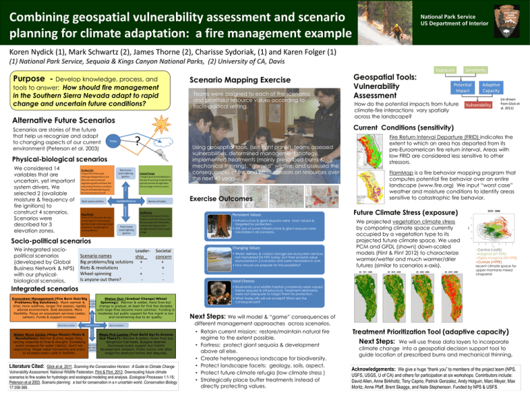
Combining geospatial vulnerability assessment and scenario planning for climate adaptation: a fire management example National Park Service US Department of Interior Koren Nydick (1), Mark Schwartz (2), James Thorne (2), Charisse Sydoriak, (1) and Karen Folger (1) (1) National Park Service, Sequoia & Kings Canyon National Parks, (2) University of CA, Davis Purpose - Develop knowledge, process, and tools to answer: How should fire management in the Southern Sierra Nevada adapt to rapid change and uncertain future conditions? Scenario Mapping Exercise Teams were assigned to each of the scenarios and prioritized resource values according to socio-political setting, Alternative Future Scenarios Scenarios are stories of the future that help us recognize and adapt to changing aspects of our current environment (Peterson et al. 2003) Today ? Using geospatial tools, (see right panel), teams assessed vulnerabilities, determined management strategy, implemented treatments (mainly prescribed burns & mechanical thinning), “gamed” wildfire, and assessed the consequences of fire and other stressors on resources over the next 40 years. We considered 14 variables that are uncertain, yet important system drivers. We selected 2 (available moisture & frequency of fire ignitions) to construct 4 scenarios. Scenarios were described for 3 elevation zones. Exercise Outcomes Persistent Values • Infrastructure & giant sequoia were most valued & targeted for protection. • Still, loss of some infrastructure & giant sequoia were inevitable in all scenarios. Socio-political scenarios LeaderScenario names ship__ Big problems/big solutions + Riots & revolutions Wheel-spinning + Is anyone out there? - Societal concern + + - Integrated scenarios Ecosystem Management (Fire Burn Out/Big Problems/Big Solutions): Much warmer & drier, more wildfires, longer fire season, rapidly altered environment. Bold decisions. More flexibility. Focus on ecosystem services (water, carbon). Funds & support increase. Status Quo (Gradual Change/Wheel Spinning): Warmer & wetter, more fires but change is gradual, at least for first few decades until large fires become more common. Funding is moderate but public support for fire mgmt is low and constraining due to air quality. Changing Values • Water delivery & carbon storage are ecosystem services not mandated for NPS today, but their societal value skyrocketed in 2 scenarios and were mandated in one. • How should we prepare for this possibility? Literature Cited: Potential Impact How do the potential impacts from future climate-fire interactions vary spatially across the landscape? Adaptive Capacity Vulnerability (re-drawn from Glick et al. 2011) Mega Fire Looms (Fuel Build Up/Is Anyone Out There?): Warmer & wetter, fewer fires but dangerous fuel loads. Budgets slashed. Decreased public support but foothill development rampant. Public outcry only after mega-fire destroys homes and sequoias. Glick et al. 2011. Scanning the Conservation Horizon: A Guide to Climate Change Vulnerability Assessment. National Wildlife Federation; Flint & Flint. 2012. Downscaling future climate scenarios to fine scales for hydrologic and ecological modeling and analysis. Ecological Processes 1:1-15; Peterson et al 2003. Scenario planning: a tool for conservation in a n uncertain world. Conservation Biology 17:358-366. Fire Return Interval Departure (FRID) indicates the extent to which an area has departed from its pre-Euroamerican fire return interval. Areas with low FRID are considered less sensitive to other stressors. FlamMap is a fire behavior mapping program that computes potential fire behavior over an entire landscape (www.fire.org) We input “worst case” weather and moisture conditions to identify areas sensitive to catastrophic fire behavior. Future Climate Stress (exposure) We projected vegetation climate stress by comparing climate space currently occupied by a vegetation type to its projected future climate space. We used PCM and GFDL (shown) down-scaled models (Flint & Flint 2012) to characterize warmer/wetter and much warmer/drier futures (similar to scenarios x-axis). - Central (<66%) –Marginal (67-90%) –Highly marginal (90-99%) –Outside (>99%) recent climate space for upper montane mixed chaparral Hard Choices • Biodiversity and wildlife habitat consistently were valued below sequoia & infrastructure. Treatment allotments were not adequate to target them for protection. • What trade-offs will we accept? What are the consequences? Next Steps: We will model & “game” consequences of different management approaches across scenarios. Water Wars Ignite (Mega Mosaic/Riots & Revolutions): Warmer & drier, larger fires, varying response to fires & drought. Increasing public pressure for water (dams). Gov’t not responding. Illegal water harvesting and arson to increase water yield in foothills. Sensitivity Current Conditions (sensitivity) Physical-biological scenarios We integrated sociopolitical scenarios (developed by Global Business Network & NPS) with our physicalbiological scenarios. Geospatial Tools: Vulnerability Assessment Exposure • Retain current mission: restore/maintain natural fire regime to the extent possible. • Fortress: protect giant sequoia & development above all else. • Create heterogeneous landscape for biodiversity. • Protect landscape facets: geology, soils, aspect. • Protect future climate refugia (low climate stress ) • Strategically place buffer treatments instead of directly protecting values. Treatment Prioritization Tool (adaptive capacity) Next Steps: We will use these data layers to incorporate climate change into a geospatial decision support tool to guide location of prescribed burns and mechanical thinning. Acknowledgements: We give a huge “thank you” to members of the project team (NPS, USFS, USGS, U of CA) and others for participation at six workshops. Contributors include: David Allen, Anne Birkholtz, Tony Caprio, Patrick Gonzalez, Andy Holguin, Marc Meyer, Max Moritz, Anne Pfaff, Brent Skaggs, and Nate Stephenson. Funded by NPS & USFS.


