SUGARCANE EXPANSION NEAR TO AGRARIAN REFORM SETTLEMENTS: A CASE
advertisement
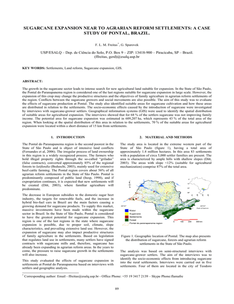
SUGARCANE EXPANSION NEAR TO AGRARIAN REFORM SETTLEMENTS: A CASE STUDY OF PONTAL, BRAZIL. F. L. M. Freitas * , G. Sparovek USP/ESALQ – Dep. de Ciência do Solo, P.O. Box 9 – ZIP: 13418-900 – Piracicaba, SP – Brazil. (ffreitas, gerd)@esalq.usp.br KEY WORDS: Settlements, Land reform, Sugarcane expansion, GIS. ABSTRACT: The growth in the sugarcane sector leads to intense search for new agricultural land suitable for expansion. In the State of São Paulo, the Pontal do Paranapanema region is considered one of the last regions suitable for sugarcane expansion in large scale. However, the expansion of this crop may change the productive structures and the objectives of family agriculture in agrarian reform settlements of the region. Conflicts between the sugarcane growers and social movements are also possible. The aim of this study was to evaluate the effects of sugarcane production at Pontal. The study also identified suitable areas for sugarcane cultivation and how these areas are distributed in relation to the settlements. The socio-economic effects caused by the introduction of sugarcane were investigated by interviews with sugarcane-grower settlers. Geographical information systems (GIS) were used to identify the spatial distribution of suitable areas for agricultural expansion. The interviews showed that for 68 % of the settlers sugarcane was not improving family income. The potential area for sugarcane expansion was estimated in 609,207 ha, which represents 43 % of the total area of the region. When looking at the spatial distribution of this area in relation to the settlements, 70 % of the suitable areas for agricultural expansion were located within a short distance of 15 km from settlements. 1. INTRODUCTION 2. MATERIAL AND METHODS The Pontal do Paranapanema region is the second poorest in the State of São Paulo and is object of intensive land conflicts (Fernandes et al, 2006). The irregular process of land ownership in this region is a widely recognized process. The farmers who hold illegal property rights through the so-called “griladas” (false contracts), converted approximately 85% of the regional forests to latifundia (Beduschi, 2003), mainly used for extensive beef-cattle farming. The Pontal region covers about 56% of all agrarian reform settlements in the State of São Paulo. Pontal is predominantly composed of public land (Itesp, 1998), and if expropriation continues, it is expected that new settlements will be created (Ditt, 2003), where familiar agriculture will predominate. The study area is located in the extreme western part of the State of São Paulo (figure 1), having a total area of approximately 1.4 million hectares. In this area 83 settlements with a population of circa 5,000 settler families are present. The area is characterized by ample hills with shallow slopes (Ditt, 2003). The areas with slope <12% (suitable for agricultural mechanization) comprise 87% of the total area. The decrease in European subsidies to the domestic sugar beet industry, the targets for renewable fuels, and the increase in hybrid bio-fuel cars in Brazil are the main factors causing a growing demand for sugarcane products. To supply this market, massive investments have been made within the sugarcane sector in Brazil. In the State of São Paulo, Pontal is considered to have the greatest potential for sugarcane expansion. This region is one of the last regions in the state where sugarcane expansion is possible, due to proper soil, climate, slope characteristics, and prevailing extensive land use. However, the expansion of sugarcane may also impact productive structures of family agriculture in the settlements. Based on legislation that regulates land use in settlements, many settlers have signed contracts with sugarcane mills and, therefore, sugarcane has already been expanding in agrarian reform areas. In the years to come, the pressure to raise sugarcane growth in the settlements will also increase. Figure 1. Geographic location of Pontal. The map also presents the distribution of sugarcane, forests and agrarian reform settlements in the State of São Paulo. The analysis was based on semi-structured interviews with sugarcane-grower settlers. The aim of the interviews was to identify the socio-economic effects from introducing sugarcane into the rural settlements. Interviews were carried out in five settlements. Four of them are located in the city of Teodoro This study evaluated the effects of sugarcane expansion in settlements at Pontal do Paranapanema based on interviews with settlers and geographic analysis. * Corresponding author: Email - ffreitas@esalq.usp.br - Office Phone: +55 19 3417 2139 – Skype Phone:flamafre 89 The International Archives of the Photogrammetry, Remote Sensing and Spatial Information Sciences. Vol. XXXVII. Part B8. Beijing 2008 Sampaio and one in Araraquara, another traditional sugarcane producing region outside Pontal. 76 interviews were completed with settlers that were producing sugarcane in co-operation with the mills. 53 interviews were conducted in four settlements located in Teodoro Sampaio and the remaining 23 interviews took place in the Monte Alegre settlement, in Araraquara. During the analysis of the data from the interviews, strong emphasis was put on sugarcane yields and management. Data collected during the interviews was analyzed with statistical software (SAS, 2000). The interviews had the following objectives: 1. To characterize the socio-economic conditions of the families after the introduction of sugarcane into the settlements; 2. To characterize the agronomic practices of the sugarcane production; Figure 2. Areas suitable for sugarcane expansion The geographic analysis was based on remote sense image classification, followed by vector, raster and DEM GIS processing for thematic integration and the area calculation. Land use was divided into the following classes: forest, sugarcane, pasture, water, urban, and other land use. Satellite images of CBERS were used for classification, using a controlled set of data with known land use (determined in field) for calibration. One of the most important aspects considered for sugarcane expansion is the distance between the mill and the cultivated areas, since longer distances result in higher transportation costs. Therefore, the expansion on the sugarcane plantations normally occurs in a radial way, since the factory gives preference to the areas next to it (Teramoto, 2003). Settlements that are located close to the mills have a greater probability to adopt this crop in cooperative contract between the settlers and the mill-owners. Two slope classes (≥12% and <12%) were calculated using an eight-neighbor algorithm based on SRTM-DEM data (Miranda, 2005). The purpose was to separate slopes <12%, which can be reached by the machines needed for sugarcane production, and areas with slopes ≥12%, which were considered unsuitable for sugarcane expansion. To identify the legally protected areas (APP), a buffer area according to the protected riparian area was calculated along the rivers. In figure 4, the frequency distribution distance histograms for suitable areas for sugarcane expansion in relation to the settlements are shown. 70% of these areas are located less than 15km of the settlements. The general maximum feasible distance of sugarcane fields to the factory was considered 30km. This distance represents 94% of the suitable areas of sugarcane expansion (figure 4). Only 6% of the area in Pontal was located over 30km of settlements, i.e. out of the range of the possible expansion area of a sugarcane mill. These areas were concentrated in the far southeastern part at Pontal (figure 3). However, it is important to consider that the economically feasible distance for sugarcane expansion for a specific mill may vary from place to place according specific circumstances that has to be considered for more precise logistic cost calculations. 3. Suitable areas for sugarcane expansion were selected by choosing areas without any restrictions for sugarcane production. Restrictions were considered as land use of forests, legally protected areas (APP), legal reserves (20% of each farm has to be maintained free from agricultural land use), slope ≥12%, water, poorly drained soils, urban areas, other land uses, and areas allocated for ecological corridors. These restrictions can be considered as comprehensive, since the occurrence of any restricting factor (not the combination of factors) resulted in a non-suitable condition for sugarcane cultivation. 3. RESULTS AND DISCUSSION 3.1. Geographic analysis The classification of satellite images identified areas of sugarcane, forest, water, pasture and other agricultural land use . In Pontal the following land were found: 55,443 ha of water surface (rivers, lakes, etc.); 53,453 ha of sugarcane (INPE); 93,939 ha of forests; 774,080 ha of pastures and 439,392 ha with other uses (perennial and annual crops, etc.). By intersecting the restricted areas with the total area of Pontal, the suitable areas for sugarcane expansion were identified (figure 2). These areas are mostly characterized by large extensive beef-cattle farms and covers 609,207ha, which is 43% of Pontal. Figure 3. Distance of the apt areas to expansion of sugarcane in relation to the settlements. 90 The International Archives of the Photogrammetry, Remote Sensing and Spatial Information Sciences. Vol. XXXVII. Part B8. Beijing 2008 from sugarcane. Table 1 and figure 5 show the results of a cluster analysis grouping the settlements according to the variables net income and sugarcane production. Figure 4. Frequency distribution distance histograms for the suitable expansion of agricultural areas in relation to the settlements. Considering the expressive expansion potential of sugarcane in Pontal, its high concentration of agrarian reform settlements, and the closeness of the areas suitable for expansion to settlements; the assumption of interaction between the mills and the settlers is plausible. Also considering that there are interactions currently existent, the understanding of these, especially on how the adoption of sugarcane as a crop or the settlers in cooperation with the mills affect income and life conditions, is important for up-scaling the expansion scenario, and predicting conflicts. The next section describes the results of interviews with sugarcane-grower settlers in relation to income, well-being, and satisfaction. 3.2. Figure 5. Settlements clusters according to the variables net income and sugarcane production Gross income from sugarcane Settlements Gross Number of Cluster income observatio (R$/ha/yea r) ns analyses Monte Alegre 680.04 14 A Santa Cruz da 466 1 B Santa Zélia 457.24 19 B Alc. da Gata 340.96 5 C Sta terezinha da 273.69 11 C Alcídia The sugarcane-grower settlers Sugarcane production in settlements is based on co-operative contracts where the mill provides the technology and also acts as guarantor towards the Bank of Brazil, so that the farmer can get the plantation started. With the loans given to the settlers by the bank, they finance R$ 14,000 (PRONAF D * ) per farm during the production cycle. This amount goes directly to the mill, which purchases the production supplies and normally also carries out part of crop management. Payments are made annually and subtracted from the harvest gains in the following way: the settlers deliver the produced sugarcane to the mill, which pays the amortization to the bank. What is left from the production after amortization is paid to the settlers in 4 monthly periods. Table 1: Average family income for producing sugarcane using the Cluster analyses. Values with the same letters are in the same group. The settlements usually don’t have infrastructure for sugarcane production and don’t organize collectively in associations or cooperatives for production. Since the settlers don’t have the appropriate machines for cultivating sugarcane, the mill undertakes most mechanization. However, this was not the case for all settlements. At Monte Alegre, for example, the settlers were better organized, and able to mechanize part of the sugarcane. In Monte Alegre the settlers organized into an association for harvesting and shipping the sugarcane themselves, resulting in a higher gross income 1 when compared to the regular contracts from the sugarcane mills (table 1). Table 2 shows that the producers, when organized into an association, showed also a greater satisfaction with the income received Families that carried out most activities in the production cycle of sugarcane (e.g. Monte Alegre), obtained a higher income than families that produced in regular contracts with the mills. Also, according to table 2, these families had a greater satisfaction with the contract. Table 2 shows that for 67.7% of the interviewed families’ sugarcane income did not influence positively income or even showed a reduction. To better characterize the satisfaction of the settlers according to the production of sugarcane, the Index of Settlers Satisfaction (ISA) was used. This index was based on questions that evaluate the opinion of the settlers regarding their relationship with the mill. Figure 6 shows the results of cluster analysis grouping the settlements according to satisfaction index with sugarcane production. * Brasilian National Programme for the Strengthening of Family Agriculture, credit line type D. 1 Gross income is considered as the income obtained from sugarcane plantation without subtracting the cost of manpower remuneration. 91 The International Archives of the Photogrammetry, Remote Sensing and Spatial Information Sciences. Vol. XXXVII. Part B8. Beijing 2008 Activity of the Who carries sugarcane pretty productive cycle through? Plantation Family Mill Was not done Family Mill Another Family Mill Family Mill Application of Pesticides Cut Shipment and Transportation Generality Families who either carried out the sugarcane production by themselves or in association (community work), more frequently pointed out some improvement in income. The opposite occurred with families who adopted the strategy of hiring services from a mill in regular contracts. How was the income of the family in relation to the previous situation on the sugarcane plantation? Improve Improve It did not It got It got Another d a lot d change worse worse --------------------------- % -----------------------5.9 52.9 11.8 11.8 17.6 2 20 54 18 6 25 37.5 12.5 12.5 12.5 0 36.4 27.3 18.2 18.2 2 22 52 18 6 0 100 0 0 0 10 55 10 10 15 2 18 56 18 6 6.3 50 12.5 12.5 18.8 2 18 56 18 6 25 4.2 75 28.2 0 42.3 0 16.9 The Housing Quality Index (HQI) integrates important aspects of housing and living conditions including conservation, construction material, and coverage. Table 4 shows that the settler’s integration with the mills does not necessarily lead to increases in the settlers’ life quality. The settlers who produced sugarcane in partnership with a mill showed an average Housing Quality Index (HQI) of 0.59, while the settlers who were not in partnership with wills in the sugarcane production showed an average HQI of 0.61 (these values didn’t differ statistically). 0 8.5 Table 2: Frequency of families replying to the question: “How is the current income situation of the family in relation to the previous income situation before sugarcane?” Partnership with mills In partnership with mills HQI 0.59 # of observations 23 Tukey A Not in partnership with mills 0.61 12 A Table 4: Comparison of HQI averages applying the Tukey test, with a 5% significance level, using as classification variable the presence or not of partnerships with factories for the sugarcane production. Tukey: Averages with the same letter don’t differ between themselves and averages with different letters differ between themselves On Table 5, where the distance between the settlement and the factory in relation to its HQI was analyzed, the settlements Santa Zélia and Santa Terezinha de Alcídia were considered as close to the mills. In these settlements most of the families had some member working at the mill or planting sugarcane in partnership with it. The settlements Ribeirão Bonito, Canaã and Primavera were considered as far from the mill, once the influence of it over these settlements is weak or nonexistent. Figure 6. Settlement clusters according to the satisfaction index with sugarcane production. Closeness to the mill Close to the mill Far from the mill Table 3 shows that the Monte Alegre settlement, where the settlers do not hire the services of the mill, had a higher ISA than the settlements that have a contract with the mill. HQI 0.59 0.39 # of observations 35 35 Tukey A B Table 5: Comparison of HQI averages applying the Tukey test, with a 5% significance level, using as classification variable the distance of the settlement in relation to the factory. The shorter distance of the settlers to the mill influenced the housing quality index. The settlers close to the mill showed an average HQI of 0.60, which, at a 5% significance level, is statistically higher than the average IQM of 0.40 presented by the families in settlements far from the mills. Probably, the employment of part of the family by the mill was a major factor influencing HQI, considering that the income from sugarcane production was not increased in these cases. Index of satisfaction of the settler with sugarcane plantation Settlements ISA Number of Cluster observation Analyses Monte Alegre 0.735 23 A Santa Zélia 0.414 25 B Santa terezinha da 0.4 18 B Alcídia Alcídia da Gata 0.381 8 B Santa Cruz da 0.275 2 C Alcídia Considering the great potential of sugarcane expansion in Pontal, the closeness of the expansion areas to settlements, and the not significant improvements under regular partnership with the mills for sugarcane production in settlers’ income and lifequality, the expansion in a business-as-usual scenario is expected to increase conflicts and result in none expressive social progress for family agriculture. Public interference, in this case, may be necessarily adopted as a strategy to promote Table 3: Comparison of the ISA for the five studied settlements, using the Cluster analyses. Values with the same letters are in the same group. 92 The International Archives of the Photogrammetry, Remote Sensing and Spatial Information Sciences. Vol. XXXVII. Part B8. Beijing 2008 sound development and positive social impacts in the nearfuture expected land-use changes. DITT, E. H. – Fragmentos Florestais no Pontal do Paranapanema, São Paulo: Annableme / Ipê / IIEB, 2002, 140p. Also, social capital and associative cooperation between settlers, expressed in collectively undertaking a major part of sugarcane production steps, were identified as key issues to improve income and positive well-being indicators by adopting this crop. Without that, measurable positive effects were only observed in settlements located extremely close to the mills, as a result of employment of part of the family members of the settlers, and not directly related to sugarcane production. FERNANDES, B. M.; FELICIANO, C. A.;WELCH, C. A. Do Pontal do Paranapanema a Ribeirão Preto: uma viagem geográfica e paradigmática para melhor compreender os modelos de desenvolvimento da agricultura – Revista de geografia, Uberlândia, v1, n. 1, p. 107-114, 2006. 4. CONCLUSIONS ITESP, FUNDAÇÃO INSTITUTO DE TERRAS DO ESTADO DE SÃO PAULO. Mediação no campo: estratégias de ação em situações de conflito fundiário.São Paulo: ITESP,1998.110 p.(Série Cadernos ITESP,n. 6). INPE, INSTITUTO NACIONAL DE PESQUISAS ESPACIAIS. Canasat - - Mapeamento da cana via imagem de satélite. Available at: < http://www.dsr.inpe.br/canasat/>. Accessed 06 Apri. 2006. The results confirm that: - The cooperation of settlers with mills (partnership for sugarcane production) did not necessarily increase settlers’ income or well-being. MIRANDA, E. E. de; (Coord.). Brasil em Relevo. Campinas: Embrapa Monitoramento por Satélite, 2005. Available at: <http://www.relevobr.cnpm.embrapa.br>. Accessed 10 Octo. 2006. - When settlers carried out the operations involved in sugarcane production, some improvements in the family’s income, in relation to the previous situation, were observed. SAS. SAS Institute. Statistical Analisys System, version 8.1, 2000. 1 CD-ROM - Further expansion of sugarcane (or any another intensive and mechanized agricultural activity) is possible 43 % of the Pontal area. SPAROVEK, G. A Qualidade dos Assentamentos da Reforma Agrária Brasileira. São Paulo, 2003. v. 1, 204p. TERAMOTO, E. R. Avaliação e aplicação de modelos de estimativa de produção de cana-de-açúcar (Saccharum spp) baseado em parâmetros do solo e do clima. Piracicaba: USP/ESALQ. 2003. 96p (Tese Doutorado). REFERENCES BEDUSCHI FILHO, L. C. Assentamentos Rurais e Conservação da Natureza: do Estranhamento à Ação Coletiva. São Paulo, IGLU, FAPESP, 2003. 93 The International Archives of the Photogrammetry, Remote Sensing and Spatial Information Sciences. Vol. XXXVII. Part B8. Beijing 2008 94
