REMOTE SENSING INTERPRETATION OF EASTERN ... FOCUSING ON TECTONIC ELEMENTS
advertisement
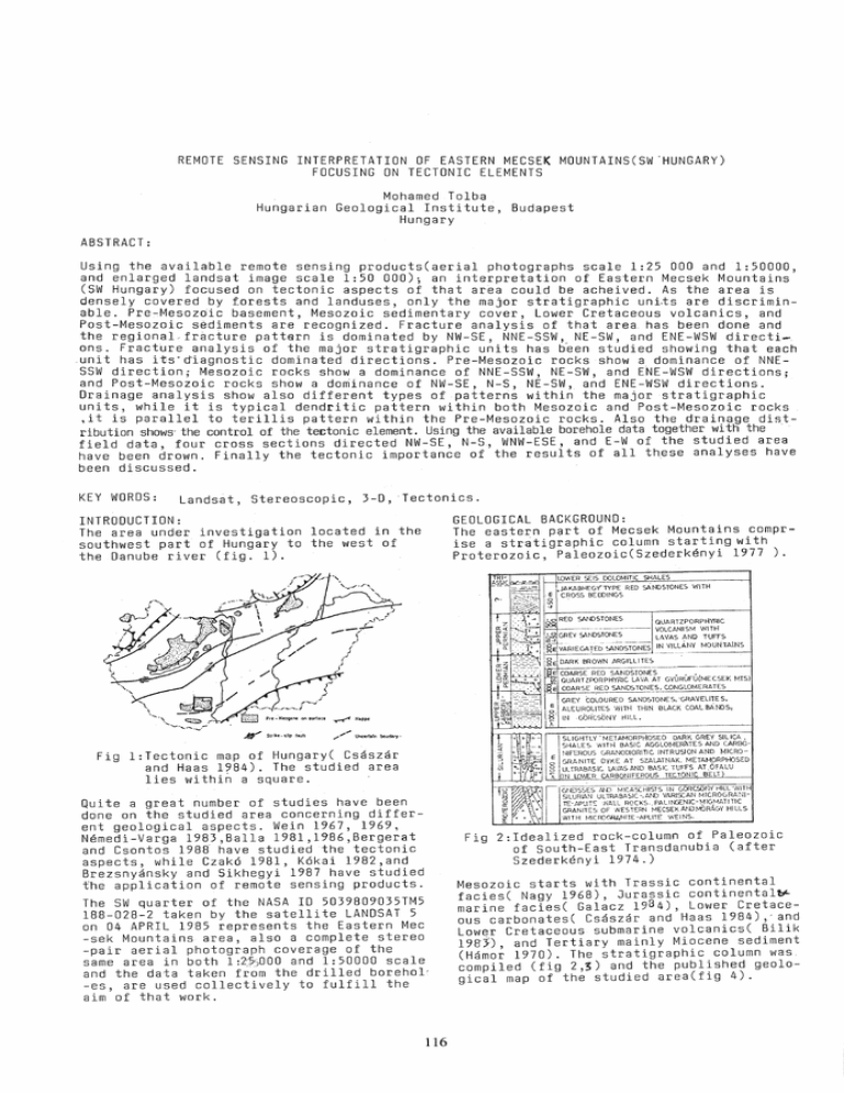
REMOTE SENSING INTERPRETATION OF EASTERN MECSEK MOUNTAINS(SW'HUNGARY) FOCUSING ON TECTONIC ELEMENTS Mohamed Tolba Hungarian Geological Institute, Budapest Hungary ABSTRACT: Using the available remote sensing products(aerial photographs scale 1:25 000 and 1:50000, and enlarged landsat image scale 1:50 000); an interpretation of Eastern Mecsek Mountains (SW Hungary) focused on tectonic aspects of that area could be acheived. As the area is densely covered by forests and landuses, only the major stratigraphic uni,ts are discriminable. Pre-Mesozdic basement, Mesozoic sedimentary cover, Lower Cretaceous volcanics, and Post-Mesozoic s~diments are recognized. Fracture analysis of that area has been done and the regional. fracture pattern is dominated by NW-SE, NNE-SSW, NE-SW, and ENE-WSW directions. Fracture analysis of the major stratigraphic units has b~en studied showing that each .unit has it5'~iagnostic dominated directions. Pre-Mesozoic rocks show a dominance of NNESSW direction; Mesozoic rocks show a dominance of NNE-SSW, NE-SW, and ENE-WSW directions; and Post-Mesozoic rocks show a dominance of NW-SE, N-S, NE-SW, and ENE-WSW directions. Drainage analysis show also different types of patterns within the major stratigraphic units, while it is typical dendritic pattern within both Mesozoic and Post-Mesozoic rocks ,it is parallel to terillis pattern within the Pre-Mesozoic rocks. Also the drainage distribution shows' the control of the te~tonic element. Using the available borehole data together with the . field data, four cross sections directed NW-SE, N-S, WNW-ESE, and E-W of the studied area have been drown. Finally the tectonic importance of the results of all these analyses have been discussed. KEY WORDS: Landsat, Stereoscopic, 3-D, Tectonics. GEOLOGICAL BACKGROUND: The eastern P9rt of Mecsek Mountains comprise a stratigraphic column starting with Proterozoic, Paleozoic(Szederk~nyi 1977 ). INTRODUCTION: The area under investigation located in the southwest part of Hungary to the west of the Danube river (fig. 1). -- - - - ~~~~~ ~ LOWER SEIS OOLQMITIC SHALES JAKABHEGY",YPE RED SANDSTONES WITH E "CROSS BE [DINGS ~ +-------------r~----------~ RED SANDSTONES QUARTZPORPHVRIC --~- - ---~- VOLCANISM WITH b~ GREY SAfJDSTONES LAVAS AND TUFFS , 0 ~~ , t-t--T=''=''=''''''''1 ~~IVARIEGATED SAND5TCJNES IN VILL.t-tlY MOUNTAINS ii~~OWN ARGILLlT~_S___~_. ___._.___ !! ~~~~;~~~p~¢R~~l~~~E;T ~ COA~~_~ED E GREY COLOURED SANDSTONES, 'GRAVELITE S, ALEUROLITES wITH THIN BLACK COAL BANDS, IN ¥Strikt~S\iPlauU / " .... Unctrlaln boudary' Fig l:Tectonic map of Hungary( Csaszar and Haas 1984). The studied area lies within a square. o t; Quite a great number of studies have been done on the studied area concerning different geological aspects. Wein 1967, 1969, N~medi-Varga 1983,Balla 1981,1986,Bergerat and Csontos 1989 have studied the tectonic aspects, while Czak6 1981, K6kai 1982,and Brezsnyansky and Sikhegyi 1987 have studied the application of remote sensing products. The SW quarter of the NASA 10 5039809035TM5 188-028-2 taken by the satellite LANDSAT 5 on 04 APRIL 1985 represents the Eastern Mec -sek Mountains area, also a complete stereo -pair aerial photograph coverage of the sam ear e a i n bot h 1: 2:S~)0 0 0 and 1: 5 0 0 0 0 s cal e and the data taken from the drilled borehol' -es, are used collectively to fulfill the aim of that work. 116 GYURlJFU(MECSEK MTS) SANDS TON_I':.~!_CONGLOMERATES GORCSONY HILL. SLIGHTLY' METAMORPHOSED DARK GREY SIL ICA • SHALES WITH BASIC AGGLONER1'ITES AND CARBONIFEROUS GRANODtORITIC INTRUSiON AND MICROGflA NITE DYKE AT SzALATNAK. METAMPRPHOSED ULTRABASIC LAVAS AND BASIC TUFFS AT .OFALU (IN LO'NER CARBONIFEROUS TECTONIC BELT 'GJEISS-ES AND MICA9::.HISTS IN GOflCSCnY HILL'WITH SILURVIN ULTRABASIC -,AND VARISCAN MICROGRANITE-APLlT'O 'NALL ROCKS .. PALINGENIC-J:1IG,MATITIC GRANITES OF WESTERN NECSEKNILlMORAGY HILLS WIT H Hie mGI1ANITE -APLITE WE INS, Fig 2:Idealized rock-column of Paleozoic of south-East Transdanubia (after Szederk~nyi 1974.) Mesozoic starts with Trassic continental facies( Nagy 1968), Jurassic continental~ marine facies( Galacz 19 8 4), Lower Cretaceous carbonates( Csaszar and Haas 1984) " and Lower Cretaceous submarine volcanics( Bilik 199j) and Tertiary mainly Miocene sediment (Hamo~ 1970). The stratigraphic column was. compiled (fig 2,3) and the published geological map of the studied area(fig 4). l!it~ 10 0 1030 100 300 H3 MECSEK Paleogeographically the Mecsek area is considered as a part of the European craton in Mesozoic which occupy a horst position in the Pannonian Basin, being elevated between Zala Basin and Drava Basin. The tectonic events affected that area can be summerized as follows: In Cretaceous,two main episodes, the first was post Berriasian resulting in folds of E-W axis; the second worked during the Austrian phase, creating ~E-SW strike. This later phase was accompnied by inverse fault mainly of north-western vergency( Wein19671 An extension-episode gave place to the intrusion of large masses of phonolites,which is related to large normal faults, orthogoal to the main strike of the chain( NemediVarga 1983). In Neogene, sedimentary basins are formed to the North and the south of the mountains, controlled by NE-SW and NW~ SE trending faults creating successive horsts and grabens pattern( Nemedi-Varga 19832 NE-SW trending folds accompanied by an imbricate structure formed in the north area in the Sarmatian age. In the Pliocene, the generation of new south vergent thrusts resulting in the bringing of Mesozoic on the top of the Lower, and then on the Upper Pannonian sediments along South Mecsek line and at the front of the Northern scale zone (Wein 1967, Nemedi-Varga 1983). The southMecsek line is meanwhile considered as big sinistral strike-slip fault, with an approximately 10 Km. offset( Nemedi-Varga 1983). In Pliocene E-W striking folds accompanied by NW-SE and N-S striking dextral wrench faults. Microtectonically the Mecsek and Villany mountains has been studied by Bergerat and Csontos 1988. They could separate five different stress fields: ESE-WNW compression associated with E-W striking dextral and NW-SE to N-S striking sinistral strike-slip faults; N-S compression associated with NWSE to NNW-SSE striking right lateral faults and NE-SW to ENE-WSW striking left lateral fault-sets; NE-SW compression creat mainly inverse faults of roughly E-W direction, also dextral strike-slip faults directed N-S to NNE-SSW; N-S extension associated with a great number of ENE-WSW to ESE-WNW directed normal faults very frequently dipslip type; and E-W extension corresponds to normal faults of NNE-SSW strike. ZONE 0 4000m my 1500 - 2000 2500 100 150 200 250 IGCP Project 198 Fig 3:Compiled stratigraphic column after IGCP Project 198."Evolution of the Northern Margin of Tethys" t, FRACTURE ANALYSIS: , .... : o PECS The airphoto fractures has been identified and annotated as developed by El Etr(1967) after Blanchet(1957) and Marchosini(1961) then Yehia(1973). The identified airphoto f r act u res <;I res how 0 ii i n fig u r e 9. Usin g the stereo-pairs under stereoscope the fractures of the studied area has been marked on overlays and the length and azimoth of each fracture have been detected. The total number of fractures(T.N) and their corresponding total length(T.L) in each azimoth class (10· of arc) are recorded for the total area and then the same has been done for each of the major stratigraphic units i.e. Pre-Mesozoic, Mesozoic, and Post-Mesozoic. The number of fractures in percentage(N%), and the length of fractures in percentage (L%) for each azimoth class have been counted(table 1). Then these data have been 10Km , ' - -_ _ _-iI!.! c=J1 mJ2 ~3 /7 4 [::(j<:]5 06 ~ 8~9 ,Xi 10 Fig 4:Geological map of Eastern Mecsek Mountains (after the geological map of Hungary 1:500 000,1984:Hungarian Geological Institute ed.). 1. Crystalline basement, 2.Triassic 3. Jurassic, 4.Cretaceous, 5.Miocene 6. Pliocene-Quaternary, 7.fault, 8. thrust, 9.syncline, 10.anticline 117 Table 1: Airphoto fractures measurements. N:number, N%:number percentage, L: length, and L%: length percentage. Total Tot~l O~;~~ 10-20 20-30 30-40 40-50 50-60 60-70 70-80 80-90 N 00-10 10-20 20-30 30-40 40-50 50-60 60-70 70-80 80-90 E N 17 10 6 N% 10.4 6. 1 3.7 17'.05 8 . 90 6 . 60 L% 8.8 4.6 Post-Mesozoic N 29 20 N% 10.4 3.4 11 7.2 3.9 13 10 14 1. 8 7 .9 6.1 8.5 6.7 2 . 65 13. 55 11. 95 12. 90 12. 65 1.4 7.0 6.2 6.7 6.6 22 22 19 25 7.9 7.9 6.8 9.0 24.00 16.S5 13.60 19.50 lS.70 19.65 22.95 L% 9.7 6.6 5.3 7.7 7.3 7.7 8.9 Mesozoi c L N 2 2 N% 2.5 2.5 2.5 2.70 5.50 2.35 7.05 1.20 L% 3.4 7.0 3.0 9.0 1.5 Pre-Mesozoic 48 34 S.S 2.5 6 2.2 2.2 5.S0 2.3 4.10 1.6 10.0 3.0 22 12 7•9 9.8 13.4 7.3 9.6 18 20 11.2 13.0 17 6.5 7.2 6.1 12.75 lS.S5 19.40 5.0 7.3 7.6 21 17 3.2 523 4 7.S 1. 2 4 . 10 2.1 10 3.6 1.4 2.4 1. 2 0.6 4 . 95 2 . S5 1. 05 2.6 1.5 0.5 3.4 15 5.4 17 6.1 4 9.05 10.90 3.10 10.10 13.10 13.80 3.5 4.2 1.2 3.9 4 5.1 5.4 4.S5 5.0 3.70 6.3 5.80 2.5 1.60 2.5 1.90 2.5 1.75 1.3 1.05 6.2 0.8 1.1 4.7 7.4 2.0 2.4 2.2 1.3 15 19 19 1.5 2.9 3.6 3.6 4.10 4.95 2.85 1.05 2.1 2.6 1.5 0.5 43 31 47 15 10 24 5.9 9.0 2.9 1.9 4.6 8.90 6.60 2.f5 13.55 11.95 12.90 12.65 2.85 4.6 3.4 1.4 1.5 6.7 6.6 21.5 26.5 54 50 35 27 10.3 9.6 6.7 5.2 10.75 lS.45 21.70 25.10 15.00 5.6 9.6 plotted on an azimoth-frequency(rose) diagram in which the N% are plotted on the upper half while the L% are plotted on the lower half (fig 6). The general characteristic of the fractures are summerized in table 1. The azimoth-frequency(rose) diagrams shows the dominance of different units, i.e. for the total area the dominant directions are NNW-SSE, NNE-SSW, ENE-WSW,and NE-SW respectively. For the area covered by Pre-Mesozoic rocks the dominant direction is NNW-SSE, for the area covered by Mesozoic rocks the dominant directions are NNE-SSW, ENE-WSW, NE-SW, and NNW-SSE respectively, for the area covered by Post-Mesozoic rocks the dominant directions are NW-SE, NNE-SSW,NE-SW, and ENE-WSW respectively. The NIL ratio can show an average of 1 Km legth of each fracture with some differences within each of the major stratigraphic units. The major trends of fractures have been plotted in fi gure 7 . The annotated fractures have been in figure 5. 11.2 13.0 164 193.05 279 1.3 26.3 21.3 0.85 16.95 20.S5 8.2 52B.25 2 1.3 0.60 27 6.2 16 5.6 5.2 7.0 13 10 . 75 18. 45 21. 70 25. 10 15. 00 17 9.26.5 17.05 L% 10.0 1. 8 2 . 85 1.5 3.3 N NI; 11 7.8 256.50 80 78.70 Fig 5: Fracture map of the studied area. Table 2: Summery of the general characteristics of fractures N L NIL Dominant directions NW NE Totai area Post-Mesozoic tvies070ic Pre-Mesuzoic 523 164 528.25 193.05 0.99 0.85 N 05,15W N 05-35W N15,25,55,75E N 15, 55-85 E 279 20 256.50 78.70 1.09 1.02 N05-25,75W N 05-l5W N05-25, 45, 75E i~L'" 12 8 4 . '. . Total area PostMesoz Mesoz -ic Mesozoic Post-Mesozoic Fig 6:Azimoth-Frequency(Rose) diagram of fractures in different units. PreMesoz. W 90 N 90 E Fig 7: Major trends of fractures in different uni ts. 118 DRAINAGE PATTERN: Studying of the drainage system of the area under consideration, it it easy to see different drainage patterns and drainage densities for different stratigraphic units. Showing the highest density in the area covered by Mesozoic rocks with typical dendritic drainage pattern, also the linearity and preferably oriented according to their tectonically affect. Concerning the area covered by Pre-Mesozoic rocks the notable remarks· are the lower drainage density and the parralell to terillis pattern reflecting a different tectonic episode. The area covered by Post-Mesozoic rocks show highly dense dendritic drainage pattern but not very often affected by t~ctonic. The drainage traces is shown in figure 8. DISCUSSION: In spite of the great coverage of the Eastern part of Mecsek Mountains by both forest ration and landuses, as well as the lack of good exposures; the general prints of the tectonic framework can be drown using the remote sensing products. The dominance of certain directions concerning the airphoto fractures which more or less coinside with supposed trends of the tectonic elements. That coinsidence is well recognized in the Mesozoic covered areas while it is confused by some deviations in the Post-Mesozoic covered areas reflecting some newtectonic elments. In case of Pre-Mesozoic covered areas it is clear that these rocks have been affected by different tectonic episode. The drainage system of the studied area is clearly affected by tectonics or it is tectonically controlled. Some quite long drainage linear features can be considered as faults proposed to be added to the published maps specially that long striaght valley connecting between Magyaregrag village and Komlo city in the western part of the study area. The cross sections construction helps in building of a three dimensional image of that area and show the prints of forces affected the area in the form of folding, faulting, and thrusting in different directions, also the unstability of the thickness of the studied rock formations give some ideas about the nature of basins in which these rocks have been deposited and hence the paleogeography of the studied area. Fig 8: Drainage map of the studied area. ACKNOLEDGEMENTS: I am very gratefull to Dr Csaszar Geza, the director of the Hungarian Central Range Department in the Hungarian Geological Institute, for his kind suggestions, guidence, advices, and following up this work. CROSS SECTIONS: Using the available drilled borehole data and the data collected from the published maps, four cross sections have been constructed (fig 9). These cross sections have been chosen in such a way that cover all structural elements of the area. The first (A-AI) directed NNW-SSE cutting across compressive tectonic element resulting in folding and thrusting specially the southern Mecsek tectonic zone which is characterized by both thrusting and strike slip components. The second (B-BI) directed N-s cutting across the major synclinal structure of the area accompanied by faulting and thrusting, it passes also through the northern Mecsek tectonic zone which is characterized by thrusting and strike-slip components. The third (C-C 1 ) directed W-E cutting through Jurassic rocks showing the tensional component reflected in normal faulting. And finally the fourth (0-01) directed NW-SE in the eastern part of the studied area cutting through the northern Mecsek tectonic zone and reach the basement on the other side of the section and reflecting the effect of the compression forces and have some thrusting which affect the Pannonian sediments which is very young (uppermost Miocene-lowermost Pliocene) relative to the supposed time of the movements. Comulatively these four cross sections can show to a certain extent the overall reflection of the different tectonic episodes which supposed to have more or less quite effect in the forming of the history of the studied area. REFERENCES: +Balla. Z. 1981. Geodynamic analysis of Cretaceous-Paleogene formations of Hungary. Alt.Foldt.Szle. ,16: 89-190. +Balla, Z. 1986.Analysis of the anti-clockwise rotation of the Mecsek Mts.(Southwest Hungary) in the Cretaceous: interpretation of paleomagnetic data in the light of the geology. Geophys. Trans. ,32(2):147-181. +Bergerat,F.& Csontos,L. 1988." Brittle tectonics and paleo-stess fields in Mecsek and Villany Mts.(Hungary):Correlation with the opening mechanism of the Pannonian basin. Acta Geologica Hungarica 31(1-2):81100. +Bilik, I. 1983. Lower Cretaceous submarine (rift) volcanism in south Transdanubia(South Hungary) In: Bisztricsanyi E. ,Szeidovtz Gy.(eds.), Proceedings offrhe Seventeenth Assembly of the Eouropean Seismological Commission. Akadimiai kiado,Budapest ,pp 569-576. +Blanchet,P.H. 1957. Development of the fracture analysis as exploration method. Amer.Assoc.Petroleum Geologists,41:1748-1759 +Brezsnyanszky, K. and Sikhegyi, F. 1987. Newtectonic interpretation of Hungarian lineam8nts in the light of satellite imagary. In I. Joo (Editor), Recent Crustal 119 A(NNW) -1000 (N) 8 -1000 C' -100'(l (NW) o (SE) 0' 0 -1000 1 ~ ~ 0 lKm Miocene ~ Lower Lias III ~Lower Triassic Phonolite r--4 -- LoweI' Lias II lE:i~JP ermi a n Lower Lias I It±±8Proterozoic ~ Cretaceous vOlcanI"cs LLlll.J.I Cretaceous sediments I~~~til Upper Triassic Upper-Middle Jurassic j~~~~1 Middle Triassic Fig 9: Cross sections A-A', 8-8', C-C', 0-0' directed NNW-SSE, N-S, W-E, and NW-SE Respectively in the studied area. +Nagy, E. 1968. A Mecsek Hegys~g Triasz id6szaki kepzodmenyi. MAFI Evkonyve (Yearbook of the Hungaria~ Geological Institute) LI(l).pp 198. +Nemedi-Varga, Z. 1983. Structural history of the Mecsek Mountains in the Alpine orogenic cycle. MAFI Evi Jelentese(Hungarian Geological Institute Annual Report,1981): 467-484. +Szederkenyi, T. 1974. Paleozoic magmatism and tectonogensis in South-East Transdaubia. Acta Geologica Sci. Hungarica,18:305 -313 +Szederkenyi, T. 1977. Geological evolution of south Transdanubia(Hungary) in Pale~ ozoic time. Acta Mineralogica Petrographica, Szeged,23(1):3-14. +Wein, Gy. 1967. DK-Dunantul hegysegszerkezte. Foldt. kozl. ,98:371-398. +Wein, Gy. 1969. Tectonic review of the Neogene-covered areas of Hungary. Acta Geologica Acad. Sci. Hungarica,13:399-436. +Yehia, M.A. 1973. Some aspects of the structural geology and stratigraphy of selected parts of the Nile basin of Upper Egypt. Unpublished Ph.D thesis, Ain Shams University, Cairo, pp323. Movements in the Carpatho-Balkan Region. Journal of Geodynamics,8:193-203. +Csaszar, G.b--Haas, J. 1984. the Cretaceous in HungarY:.A review. Acta Geologica Hungarica,27(3-4):417-428. +Czako, T. 1981. Structural analysis of Western Hungary. Adv. Space Res. ,1:237-247. +El Etr, H.A. 1967. The technique of lineation and linear analysis and its application in the minorogenic province of South Missouri. Unpublished Ph.D Thesis, University of Missouri al Rolla USA pp 249. :Gal~cz, A. 1984. Jurassic of Hungary: a reVIew. Acta Geologica Hungarica 27(3-4)· 359-377. , . +Hamor, G. 1970. A keleti-Mecseki Miocen. MAFI Evkonyve (Yearbook of the Hungarian Geological Institute) II(1):pp483. +IGCP 198. 1989. Evo1utivn of northern margin of tethys. . +Kok8i, A. 1982. The geological and tectonic setting of SE Transdanubia (W. Hungary) as shown by landsat-1 imagery. MAFI Evi Jelentese(Hungarian Geological Institute Annual Report,1980):501-508. +Marchosini, E. 1961. Photogeology applied to natural stream exploration. O.N.U. conference sur Ie sources nouvelles d'energie, Rome. 120

