MONTHLY WEATHER REVIEW
advertisement

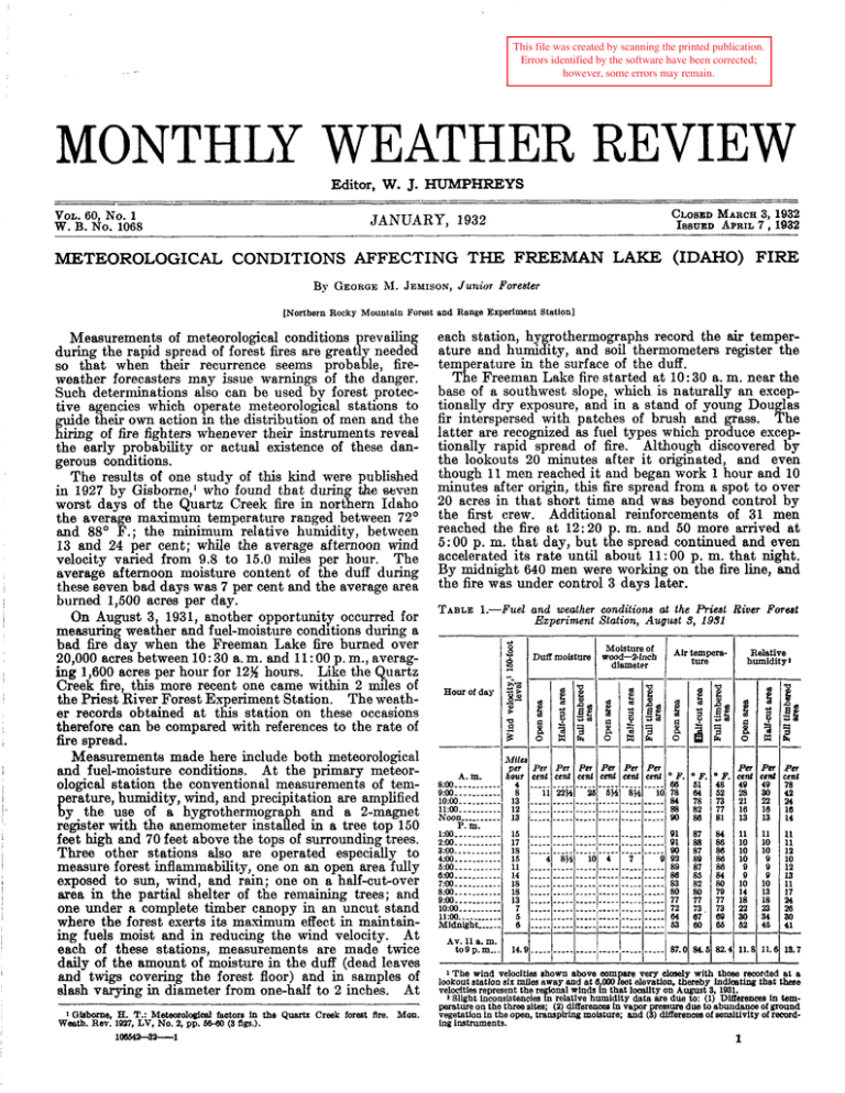
This file was created by scanning the printed publication. Errors identified by the software have been corrected; however, some errors may remain. MONTHLY WEATHER REVIEW Editor, W. J. HUMPHREYS VOL. 60,No. 1 CLOSEDMARCH3, 1932 ISSUED APRIL7,1932 JANUARY, 1932 W.B. No. 1068 METEOROLOGICAL CONDITIONS AFFECTING THE FREEMAN LAKE (IDAHO) FIRE By GEORGEM. JEMISON,Junior Forester [Northern Rocky Mountain Forest and Range Experiment Station] Measuremeqts of meteorological conditions prevailing during the rapid spread of forest fires are great1 needed so that when their recurrence seems proba le, fireweather forecasters may issue warnings of the danger. Such determinations also can be used by forest protective agencies which operate meteorological stations to guide their own action in the distribution of men and the hiring of fire fighters whenever their instruments reveal the early probability or actual existence of these dangerous conditions. The results of one study of this kind were published in 1927 by Gisborne,' who found that during the wven worst days of the Quartz Creek fire in northern Idaho the average maximum temperature ranged between 72' and 88' F.; the minimum relative humidity, between 13 and 24 per cent; while the average afternoon wind velocity varied from 9.8 to 15.0 miles per hour. The average afternoon moisture content of the duff during these seven bad days was 7 per cent and the average area burned 1,500 acres per day. On August 3, 1931, another opportunity occurred for measurin weather and fuel-moisture con&tions during a bad fire ay when the Freeman Lake fire burned over 20,000 acres between 10: 30 a. m. and 11 :00 p. m., averaging 1,600 acres per hour for 12%hours. Like the Quartz Creek fire, this more recent one came within 2 miles of the Priest River Forest Experiment Station. The weather records obtained at this station on these occasions therefore can be compared with references to the rate of fire spread. Measurements made here include both meteorological and fuel-moisture conditions. A t the primary meteorological station the conventional measurements of temerature, humidity, wind, and precipitation are amplified !y the use of a hygrothermogra h and a 2-magnet register with the anemometer insta ed in a tree top 150 feet high and 70 feet above the tops of surrounding trees. Three other stations also are operated especially to measure forest inflammability, one on an open area fully exposed to sun, wind, and rain; one on a half-cut-over area in the partial shelter of the remaining trees; and one under a complete timber canopy in an uncut stand where the forest exerts its maximum effect in maintaining fuels moist and in reducing the wind velocity. At each of these stations, measurements are made twice daily of the amount of moisture in the duff (dead leaves and twigs c0veh.g the forest floor) and in samples of slash varying in diameter from one-half to 2 inches. At t % s 1 Ohborne E. T.: Metemologieal factore in the Quartz Creek forest Are. Mon. Weath. Rev: 1W7, LV, No. 2, pp. Mwo (3 5gs.). 10054!a4~-1 each station, hygrothermographs record the air temperature and humidity, and soil thermometers register the temperature in the surface of the duff. The Freeman Lake fire started at 10: 30 a. m. near the base of a southwest slope, which is naturally an exceptionally dry exposure, and in a stand of young Douglas fir interspersed with patches of brush and grass. The latter are recognized as fuel types which produce exceptionally rapid spread of fire. Although discovered by the lookouts 20 minutes after it originated, and even though 11 men reached it and began work 1 hour and 10 minutes after origin, this fire spread from a spot to over 20 acres in that short time and was beyond control by the first crew. Additional reinforcements of 31 men reached the fire at 12:20 p. m. and 50 more arrived at 5:OO p. m. that day, but the spread continued and even accelerated its rate until about 11:OO p. m. that night. By midnight 640 men were working on the fire line, and the fire was under control 3 days later. TABLE1.-Fuel * and weather conditions at the Biest River Forest Experiment Station, August 3, 1931 Relative humidity1 22 -5% - - -c8" 8 - P B Y B E E= e -- Et $ % - -- z W 2 34 s Mile 3 0 - prr pa per hour OF 61 64 78 82 4 8 13 12 13 88 87 15 17 18 16 11 14 18 18 13 7 5 6 88 87 89 87 85 82 80 77 73 67 60 14. 84. ' F. cent 48 49 52 m cenl 49 a0 2P.?T :ent 78 42 73 77 81 21 16 13 n I34 86 11 10 10 10 9 9 10 14 18 22 11 10 10 9 9 9 10 13 18 11 11 12 10 12 13 11 17 23 34 46 a0 11. 13.7 86 88 88 84 80 79 77 73 60 86 - a0 M c 82.1 11. I 18 13 - m 16 14 m 28 41 - --- - - 1 The wind velocities shown above wm are very closely with thaw recorded at a lookout statlon sir mlles away and at 6 OOO elevation thereby lndloating that these velocities represept the rylonal winds in that l d t y on' August 3, 1831. 2 Slight inconsntenc!es n relative humidity data are due to: (1) Dlffmncea in temperature on the three alter (2) differences In vapor pressure due to abundance of ground vegetation in the open, tdnsplrhg molsture; and (3) dlfXerenceaof sensitivity of recording instruments. kt 1 2 MONTHLY WEATHER REVIEW The course of this conflagration was with the wind from a southwest to a northeasterly direction, in spite of various timber and fuel types, sharp ridges, valleys, cultivated fields, r o d s , and rivers. By the morning of August 4 an area 5 miles wide by 11% miles long had been burned over, with several spot fires still farther ahead and as much as 15 miles from the point of origin. Over 20 of these spots were finally controlled before they burned together or backed to the main fire. The largest reached a size of 350 acres and was 3 miles ahead of the main fire. Thia unusual rate of spread obviously points to the great importance of two factors; viz, extreme d ness of the fuel types, and wmd as a propelling agent an carrier of blazing embers to start spot fires. These conditions as well as air temperature and relative humidity, are shown in Table I as they were measured at the Priest River station about 2 d e s north of the fire. In considering these temperatures and humidities, they should be compared to the 20-year normal maximum temperature of 84.23 F. and tho 5: 00 p. m. relative humidity of 38 per cent for August 3 a t this station. 7 JANUARY, 1932 These data show that when duff and wood moisture contents are as low as 4 or 5 per cent in the open and 9 or 10 per cent under dense timber, wind velocities of 12 to 18'miles per hour, together with maximum temperatures of 90' or 92O F., and humidities of 9 or 10 per cent result in possible spread of fire at about 1,600 acres per hour in northern Idaho. When these conditions are compared with the measurements made by Gisborne in 1926, it is apparent that the difference between 1,500 acres per day and 1,600 acres per hour is due to what might have been considered as relatively sniall differences in fuel moisture, wind, temperature, and humidity. This comparison shows very closely, however, that these small differences combine to produce a most exceptional rate of spread of fire. This also demonstrates the importance of recognizing and forecasting temperatures of over 90° F., humidities around 10 per cent, coupled with winds of only moderate velocity, when the duff and slash moisture contents are under 5 per cent. At such times, every effort in control must be made if fires are to be reached and restricted before they grow to such great size as to require.tremendous expense for their suppression. EVAPORATION FROM LAKES AND RESERVOIRS By C. E. GRUNSKY [September 19311 What baa heretofore been published on the experimental data relating to evaporation must be used with caution. The United States Weather Bureau standard evaporation pan A, a land pan, does not furnish a satisfactory basis for comparing the evaporation from a large body of water in one place with that from another body of water in some other place. The same is true of most floating pans, nearly all of which have been insufficiently immersed. The Chestnut Hill Reservoir records by Desmond Fitzgerald' were obtained in part from a floating pan, the water in which sometimes differed as much as 10' F. from the outside water. The F. H. Bigelow experiments under direction of the United States Weather Bureau a t Salton Sea with a battery of pans called floating pans were made with pans whose water surface was 3 or 4 inches above the surrounding water. These Bigelow records should not be credited to floating pans which should always have their water surface lower than that of the outside water. A new type of land pan with shaded rim is below suggested, Wind effect on evaporation being taken into account the ordinary relation of evaporation to mean monthly air temperature is indicated in this contribution both in a table and by diagram. An altitude factor is suggested to be used until something better is found. The writer desires to suggest the use of a type of land pan which w i l l give results for some periods of time, such as the month, which will better indicate the relative amount of evaporation loss from widely separated large open-water surfaces. Furthermore, he presents some conclusions bearing on the relation of the mean monthly evaporation rate to mean monthly temperature, with inclusion of the effect on this rate of air movement and altitude. The standard evaporation pan A of the United States Weather Bureau conforms substantially to the following description : ~7!ranmctIona.Am. Boc. C. E.,Vol. XV. The pan is circular, 48 inches in diameter, 10 inches deep, and is filled with water to a depth of about 8 inches. I t is built of galvanized iron and rests on wooden supports placed on the surface of the ground. Pans of this character are widely distributed throughout the country and are intended to afford a basis for comparison of evaporation rates in different localities. The measurements of water loss from such pans with suitable correction factors are also supposed to serve as a dependable guide when evaporation from open water surfaces is to be approximated. The standard pan seems to have been constructed with a view to giving maximum effect to the various factors which contribute to the rate of evaporation. Thus, for example, the sides and bottom of the pan are exposed to air, free circulation even under the pan being prescribed. The sides of the pan outside and inside have maximum exposure to sunshine. The result of this arrangement IS that the water in the pan in sunshiny warm weather is materially warmer than the surface of a broad sheet of water would be, and in cold weather it cools off more rapidly. Moreover, the sunshine, which is practically continuous from sunrise to sunset at some places and very spasmodic at other places, falling upon the sides of the pan not only imparts heat to the water in the pan by transmission through the metal of which the pan is made and thereby accelerates evaporation, but the sides of the pan above the water frequently become quite hot and the wind ripples splashing up against and wetting these sides and evaporatmg therefrom unduly increase the water loss from the pan. When it is considered that an open body of water has only its surface exposed to the sunshine and air and that there are no vertical metal confining sides around small areas, then the inadequacy of this arrangement becomes apparent. The heat of the sun imparted to the sides of the pan is not a factor that can be evaluated. Sunshine is not continuous; it is not the same from day to day. In the


