Document 11478204
advertisement
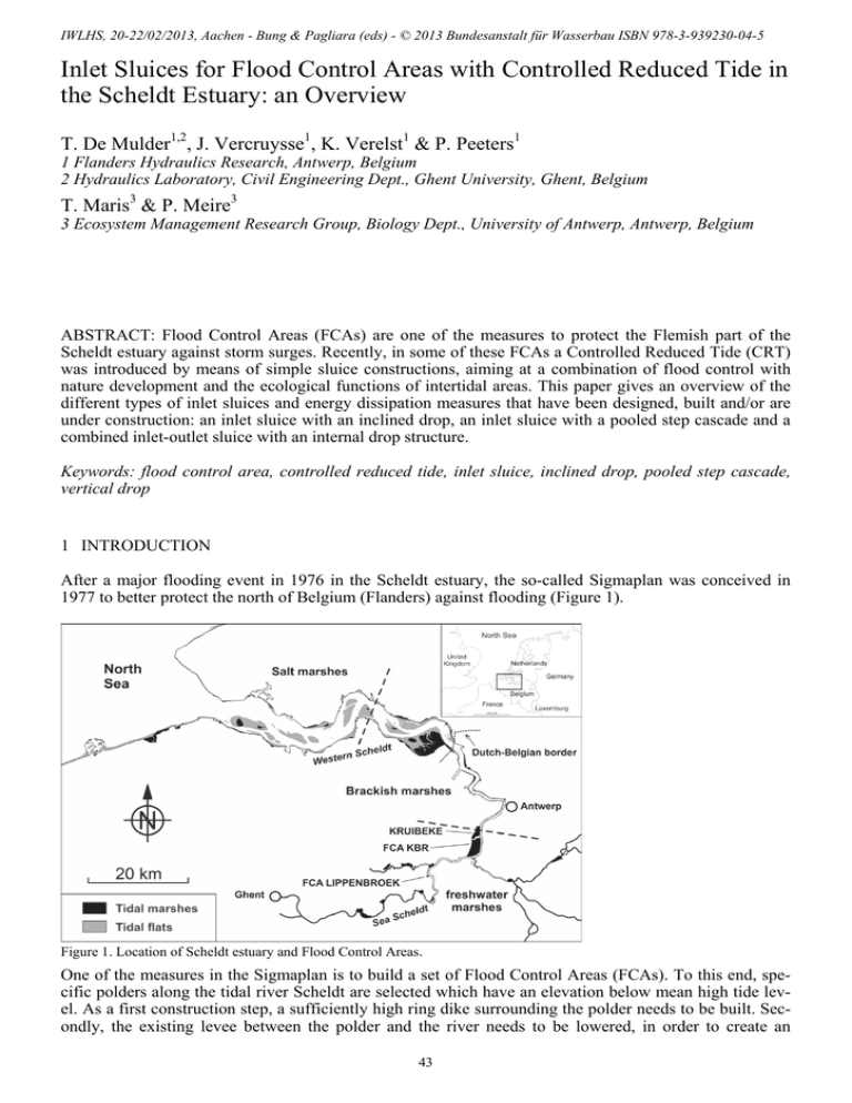
IWLHS, 20-22/02/2013, Aachen - Bung & Pagliara (eds) - © 2013 Bundesanstalt für Wasserbau ISBN 978-3-939230-04-5 Inlet Sluices for Flood Control Areas with Controlled Reduced Tide in the Scheldt Estuary: an Overview T. De Mulder1,2, J. Vercruysse1, K. Verelst1 & P. Peeters1 1 Flanders Hydraulics Research, Antwerp, Belgium 2 Hydraulics Laboratory, Civil Engineering Dept., Ghent University, Ghent, Belgium T. Maris3 & P. Meire3 3 Ecosystem Management Research Group, Biology Dept., University of Antwerp, Antwerp, Belgium ABSTRACT: Flood Control Areas (FCAs) are one of the measures to protect the Flemish part of the Scheldt estuary against storm surges. Recently, in some of these FCAs a Controlled Reduced Tide (CRT) was introduced by means of simple sluice constructions, aiming at a combination of flood control with nature development and the ecological functions of intertidal areas. This paper gives an overview of the different types of inlet sluices and energy dissipation measures that have been designed, built and/or are under construction: an inlet sluice with an inclined drop, an inlet sluice with a pooled step cascade and a combined inlet-outlet sluice with an internal drop structure. Keywords: flood control area, controlled reduced tide, inlet sluice, inclined drop, pooled step cascade, vertical drop 1 INTRODUCTION After a major flooding event in 1976 in the Scheldt estuary, the so-called Sigmaplan was conceived in 1977 to better protect the north of Belgium (Flanders) against flooding (Figure 1). Figure 1. Location of Scheldt estuary and Flood Control Areas. One of the measures in the Sigmaplan is to build a set of Flood Control Areas (FCAs). To this end, specific polders along the tidal river Scheldt are selected which have an elevation below mean high tide level. As a first construction step, a sufficiently high ring dike surrounding the polder needs to be built. Secondly, the existing levee between the polder and the river needs to be lowered, in order to create an 43 overflow dike. During storm surges, water can overtop the overflow dike and be stored in the FCA, thus damping the tidal wave in the river and mitigating the flooding of nearby valuable areas. To drain the water from the FCA when the water level in the river is sufficiently low again, outlet sluices are included within the overflow dike (Figure 2, left). The corresponding culverts are equipped with flap gates on the river side. On average, such a FCA is flooded once or twice a year. A dozen of FCAs are currently operational, and many more are under design and/or construction. Figure 2. Operation principles of a Flood Control Area (FCA) without (left panel) and with (middle and right panels) a Controlled Reduced Tide (CRT) Due to changing physical circumstances and new insights in water management, an actualization of the Sigmaplan was elaborated in 2005, aiming at satisfying both safety and ecological needs along the river Scheldt in a sustainable way. Among other measures, some FCAs are now being designed and constructed with a so-called Controlled Reduced Tide (CRT) (Maris et al., 2007). Such type of FCAs (further abbreviated as: FCA-CRTs) does not only flood during storm surges, but also in normal tidal conditions. To this end, inlet sluices are built high in the river dike. During a (semi-diurnal) tidal cycle, a limited amount of river water flows into the FCA (Figure 2, middle), as long as the water level in the river exceeds the invert level of the inlet sluices. When inflow ceases, the water level in the FCA stagnates. As soon as the water level in the river becomes sufficiently low again, water is drained from the FCA through the outlet sluices in the overflow dike (Figure 2, right). When the water level in the river becomes sufficiently high again, the flap gates of the outlet sluices close and outflow from the FCA ceases, yielding again a stagnating water level. The tidal regime aimed at within the FCA, should be comparable to tides in the estuary, but adapted to the scale of the FCA. For the development of functional intertidal habitat (i.e. tidal marshes and tidal flats) the low elevated FCA area has to face similar inundation frequencies as the natural outer dike habitats. Natural marshes only flood during spring tide, tidal flats can be flooded every tide. To achieve similar inundation patterns in the FCA, the high water levels have to be reduced without damping the spring tide – neap tide variation. This can be achieved by well-designed high positioned inlet sluices that take in large volumes of water during spring tide but, thanks to the high position, nearly no water during neap tide. A low elevated outlet sluice evacuates the water during ebb. In this way, FCA-CRTs intend to contribute to the restoration of estuarine habitats, many of which have disappeared or degraded over the course of time because of agricultural, urban or industrial developments in a densely populated and land-scarce Scheldt estuary region (Cox et al., 2006). Intertidal areas have important ecological functions with effects on aeration, cycling and recycling of nutrients, water quality, sedimentation and primary production (Maris et al., 2007). Because of the safety function – i.e. providing storage capacity to mitigate storm surges – that a FCACRT still needs to fulfill, only simple, reliable and easy to maintain technology should be relied upon for the introduction of a reduced tide. Therefore, robust inlet sluice systems have been selected, based upon culverts, possible equipped with valves. Also safeguarding the storage capacity needed for storm events is essential. With a reduced tide, the exchanged water volumes and hence suspended matter, can be controlled. Sluice dimensions determine flooding frequencies that influence sedimentation rates. The sill level and the cross-section of the inlet sluices have been determined by means of mathematical models, simulating the tidal water levels in the polder for given water levels in the river. Instead of constructing the floor slab of the culverts at the sill level predicted by the mathematical models (in order to get the requested tidal regime in the polder), it was decided to put the floor slab about 0.5 m lower and add some overflow weirs (e.g. at the downstream end of the inlet sluice culverts). Those weirs can be made easily by piling up stop logs in the available recesses in the vertical culvert walls. Hence, by choosing the appropriate weir height, the intake level(s) of the inlet sluice can be set to the requested value(s). Moreover, once the FCA-CRT is operational, the heights of the stop log weirs can be easily adapted, if needed to optimize the inundated areas and/or to respond to evolutions in the FCA-CRT or in the river. 44 Since FCAs are constructed in polders with a relatively low mean elevation (in order to maximize the storage capacity for flood mitigation), the water flowing in through the inlet culverts needs to drop significantly. If no special measures were taken, high flow velocities would result in important erosion. This is inacceptable for reasons of stability of the inlet sluice construction itself, as well as for the stability of the overflow dike in which the sluice is constructed. Therefore, some energy dissipating (and erosion protection) measures have to be included in the design of the inlet sluice for a FCA-CRT. This paper gives an overview of some structures that have been designed and/or built in the Scheldt estuary. 2 INLET SLUICE WITH INCLINED DROP – PILOT PROJECT “LIPPENBROEK” A fairly small polder of about 10 ha, called “Lippenbroek” (municipality: Hamme), was selected to become a pilot project. The FCA-CRT Lippenbroek became operational in March 2006. The polder is situated in the freshwater part of the estuary (Figure 1). Scheldt Ring dike Ring dike Outlet sluice Inlet sluice Central ditch Overflow dike Ring dike Ring dike Figure 3. Aerial view of FCA-CRT Lippenbroek (source: www.sigmaplan.be). The FCA is surrounded by a ring dike. The levee between river and polder is 450 m long, 40 m of which have been lowered to function as an overflow dike (Figure 3). The (new) inlet sluice has been constructed at a distance of about 50 m from the (existing) outlet sluice. At the riverside, a creek connects both sluices to the river. At the polder side, an inlet basin connects both sluices to a central ditch or creek within the polder (Figure 4). Some characteristic levels and sluice dimensions for FCA-CRT Lippenbroek are given in Table 1 and Table 2 respectively. The levels are expressed with respect to TAW, i.e. the Belgian reference level (which is approximately the mean low tide level along the Belgian North Sea coast). Outlet sluice Inlet sluice Stop log weirs Inlet basin Central ditch Figure 4. View from polder upon inlet sluice and outlet sluice of FCA-CRT Lippenbroek (left) and upon stop log weirs at downstream end of inlet sluice culverts (right) 45 Table 1. Characteristic levels for FCA-CRT Lippenbroek. FCA-CRT Lippenbroek Ring dike Crest level +8.35 m TAW Levee Crest level +8.00 m TAW Overflow dike Crest level +6.80 m TAW Inlet sluice Level of culvert ceiling +5.90 m TAW Crest level of stop log weirs +5.30/+5.00/+4.70 m TAW Level of culvert floor +4.00 m TAW Outlet sluice Level of culvert ceiling +3.00 m TAW Level of culvert floor +1.50 m TAW Polder Mean elevation +2.6 m TAW Tidal river characteristics mean high tide +6.0 m TAW (spring tide) +5.6 m TAW (mean tide) +5.1 m TAW (neap tide) mean low tide +0.1 m TAW (spring tide) +0.3m TAW (mean tide) +0.5 m TAW (neap tide) Table 2. Characteristic culvert dimensions for sluices of FCA-CRT Lippenbroek. Inlet sluice Outlet sluice Number of culverts 3 Number of culverts 1 Culvert width 1.00 m Culvert width 1.50 m Culvert height 1.90 m Culvert height 1.50 m Culvert length ca. 13 m Culvert length ca. 40 m The geometry of the inlet sluice is depicted in Figure 5. An inclined drop has been chosen to direct the water inflow through the culverts into the Lippenbroek polder. Besides some orientating hydraulic calculations, no explicit reference was made to specific recommendations in (hydraulic) literature to select and size this type of construction. Given the limited vertical drop height and inlet sluice dimensions in this pilot project, a (gently) sloping concrete slab of moderate size (without chute blocks and baffle blocks) was just believed to be simple to construct and elegant to integrate in the landward slope of the dike (since sidewalls protruding above the dike slope could be avoided). The inclined slab has a slope of 13.5%, corresponding to a drop in height of 2.25 m over a horizontal distance of 16.57 m. Due to diverging sidewalls (each having an angle of about 5° with respect to the longitudinal axis of the slab), the slab width varies from 4 m at the top to 7 m at the toe. The total area of the slab is about 92 m². At the toe of the drop, a stilling basin has been constructed. It consists of a horizontal concrete slab (with a small end sill), surrounded by gabions. The sizing of the slab has been based on calculations of the hydraulic jump during various tidal cycles in the river, taking into account the time evolution of the tail water depths in the polder. The maximum Scheldt level considered during these design calculations was at mean spring tide (+6.0 m TAW, Table 1), corresponding to an estimated total discharge of 6.5 m³/s, i.e. a specific discharge at the top of the inclined drop of 1.6 m³/s/m. The latter value has been confirmed by discharge measurements on site in Lippenbroek (Peeters et al., 2009). The resulting length of the concrete slab is about 7 m. Combined with a width of 15 m, yields a slab surface of about 100 m². Note that the construction occasionally also operates under much higher water levels in the river, hence much higher specific discharges. For a Scheldt level of +6.8 m TAW– i.e. the crest level of the FCA overflow dike, which is exceeded on average once or twice a year – the specific discharge is estimated (based on a culvert formula, validated by scale model tests) to be 3.1 m³/s/m. No stability issues regarding possible erosion downstream of the stilling basin were raised: (i) Given the limited surface of the polder and its specific topography, high inflow discharges result in rapidly increasing tail water depths, hence limited duration of exposure to non-protected parts of the inlet basin and shifting of the hydraulic jump in the direction of the inclined drop. (ii) Because the inlet sluice construction was completely surrounded by sheet pile walls, the structural engineers did not consider the potential erosion to be harmful for the stability of the construction. (iii) The location of the potential erosion was considered to be sufficiently far from the landward slope of the neighboring dike sections. (iv) Regular monitoring in the FCA-CRT was planned and, if needed, the authorities in charge of the FCA-CRT were ready to restore and/or increase additional erosion measures such as gabions. (v) The ecological engineers are in favor of hydraulic conditions that stimulate the morphodynamic evolution (creek formation) of the polder (as long as the constructional stability of sluice and dike are not at stake, of course). 46 Figure 5. Sketch of inlet sluice for FCA-CRT Lippenbroek Since the FCA-CRT is operational (March 2006), neither constructional problems have been observed, nor excessive erosion in the immediate neighborhood of the inlet sluice construction. Note that in March 2006, the crest levels of the stop log weirs in the three inlet culverts have been adapted somewhat, in order to create sufficiently different inundated areas in the polder during spring and neap tide conditions. The uniform crest level of +4.8 m TAW (i.e. the value that was assumed for all inlet culverts during the design calculations) was modified into varying crest levels of +4.7/+5.0/+5.3 m TAW (i.e. the values that are specified in Table 1 and are illustrated in Figure 4). Since then, no further changes have been made to the crest levels of the stop log weirs. Figure 6. Energy dissipation and aeration of water flowing into FCA-CRT Lippenbroek (left: view from polder towards inlet sluice ; right: view from inlet sluice towards polder). The inlet and outlet sluice systems described above, allow the tidal amplitude in the polder to be reduced on average from 5 m (in the river) to 1 m (in the polder), but the natural spring-neap tidal cycle is maintained. The tidal range in the polder varies from a few decimeters at neap tide to over 1.5 m at spring tide (Beauchard et al., 2011). The form of the tidal curve in the polder differs from the one in the estuary, as a stagnant phase is present both at high and low water in the polder, but the crucial characteristics of the tide for ecological purposes are still present. 47 Figure 6 illustrates the energy dissipation and aeration that accompanies the inflow of water into FCACRT Lippenbroek. Based on intensive ecological monitoring since the FCA-CRT is operational, the amount of aeration provided by the inlet construction is considered to be satisfactory. 3 INLET SLUICE WITH POOLED STEP CASCADE – CASE “KBR” The largest FCA set up in Flanders so far, has a total area of about 600 ha and is referred to as “KruibekeBazel-Rupelmonde” (abbreviated: KBR). A Controlled Reduced Tide will be introduced in several parts of KBR. The one in the polder called “Kruibeke” will be referred to as FCA-CRT Kruibeke (Figure 7). It has an area of about 200 ha and is situated at the limit of the brackish zone of the Scheldt estuary (Figure 1). FCA-CRT Kruibeke is to date (November 2012) not yet operational. Outlet sluice Inlet sluice Inlet sluice Gabions Figure 7. View upon outlet and inlet sluices (left) and bottom protection downstream of end sill inlet sluice (right) constructed at FCA-CRT Kruibeke The levee between river and polder for FCA-CRT Kruibeke is about 1900 m long, 1650 m of which will function as an overflow dike. The inlet and outlet sluices are built adjacent to each other in the north of the polder (Figure 7), in order to concentrate the tidal energy in one place. Some characteristic levels and sluice dimensions for FCA-CRT Kruibeke are given in Table 3 and Table 4 respectively. Table 3. Characteristic levels for FCA-CRT Kruibeke. FCA-CRT Kruibeke Tidal river characteristics Ring dike Crest level +8.35 m TAW mean high tide +5.8 m TAW (spring tide) +5.4 m TAW (mean tide) Levee Crest level at sluices +8.35 m TAW +4.9 m TAW (neap tide) Overflow dike Crest level +6.80 m TAW Inlet sluice Level of culvert ceiling +6.40 m TAW mean low tide -0.2 m TAW (spring tide) +0.0m TAW (mean tide) Crest level of stop log weirs +4.70 to +5.50 m TAW* +0.4 m TAW (neap tide) Level of culvert floor +4.20 m TAW Outlet sluice Level of culvert ceiling +2.70 m TAW Level of culvert floor +0.50 m TAW Polder Mean elevation +1.3 m TAW * Range of crest level stop log weirs considered during design. Levels to be tuned when FCA-CRT is in operation. Table 4. Characteristic culvert dimensions for sluices of FCA-CRT Kruibeke. Inlet sluice Outlet sluice Number of culverts 15 Number of culverts 15 Culvert width 3.00 m Culvert width 3.00 m Culvert height 2.20 m Culvert height 2.20 m Culvert length ca. 25 m Culvert length ca. 55 m 48 The geometry of the inlet sluice is sketched in Figure 8. Note that instead of an inclined drop (like the FCA-CRT Lippenbroek), a stepped cascade was chosen to direct the water inflow through the culverts into the Kruibeke polder. Several considerations motivated this choice: (i) The drop height between the floor level of the inlet culverts and the mean elevation of the polder is much higher at Kruibeke (2.9 m) as compared to Lippenbroek (1.4 m). (ii) The total width of the inlet sluice is much larger in Kruibeke (ca. 51 m) as compared to Lippenbroek (4 to 7 m). The construction of an inclined slab of such a size is more difficult. (iii) The water board in charge of the FCA-CRT decided to change the design conditions. Before, it was assumed that the inlet culverts would be closed manually (e.g. by closing a slide gate in each inlet culvert) prior to early flood warnings that predicted overtopping of the overflow dike. This measure was intended to maximize the storage capacity available in the FCA for storm surge mitigation. After the decision of the water board, it could no longer be assumed that the inlet culverts would be closed in such circumstances. Hence, the design Scheldt level could be higher than the crest level of the FCA overflow dike (+ 6.8 m TAW). (iv) The surface of the FCA-CRT Kruibeke (200 ha) is much larger than FCA-CRT Lippenbroek (10 ha) and additionally, the topography at Kruibeke gives rise to a slow increase of the tail water depths in the polder in response to water inflow. (v) During the design of the inlet sluice at Kruibeke fish migration was of much more concern than during the (earlier) design at Lippenbroek. Therefore, a pooled step cascade was selected, since this type of construction was considered to be less harmful for fish migrating towards the polder through the inlet sluice culverts. (vi) The extra aeration that a cascade was likely to produce (as compared to an inclined drop) was considered to be an ecological asset. The cascade consists of three steps, the dimensions of which are presented in Table 5 and Figure 8. Every step has an end sill, turning the construction into a pooled step cascade. To protect fish migrating from the river into the polder via the inlet sluice, the ecological engineers required the height of the end sill, i.e. the pool depth, to be at least one third of the drop height between consecutive steps. Figure 8. Sketch of inlet sluice for FCA-CRT Kruibeke. During the design, Scheldt levels up to +8.0 m TAW have been considered, i.e. levels that are significantly above the crest level of the FCA overflow dike (+6.8 m TAW). Such high levels – though accompanied by relatively high tail water depths due to the preceding filling of the polder – still might give rise to supercritical flow above parts of the inlet sluice construction. The specific discharge (estimated with culvert formulas, validated by scale model tests) and critical flow depth corresponding to various high tide levels and crest levels of the stop log weirs are presented in Table 6. The cascade has been dimensioned for nappe flow, based upon the guidelines in Chanson (2002 & 2004). These guidelines, however, are not valid for pooled step cascades, of which the hydrodynamics was still poorly known at the time. Therefore, it was decided to test the design afterwards in a scale model (scale 1:12) at Flanders Hydraulics Research (De Mulder et al., 2011). 49 Table 5. Characteristic dimensions of pooled step cascade for FCA-CRT Kruibeke. Upper step Intermediate step Lower step brink level of falling jet [m TAW] +4.7 to +5.5* +3.5 +1.5 floor level upstream [m TAW] +4.2 +2.5 +0.5 floor level downstream [m TAW] +2.5 +0.5 -1.0 step height (s) [m] 1.7 2.0 1.5 step length (L) [m] 10.0 10.0 11.5 slope (s/L) [-] 0.17 0.20 0.13 weir or end sill height (w) [m] 0.5 to 1.3* 1.0 1.0 drop height of falling jet (w+s) [m] 2.2 to 3.0* 3.0 2.5 * Depending on crest level of stop log weirs. Table 6. Specific discharge and critical flow depth for FCA-CRT Kruibeke. Scheldt level Crest level stop log weirs Specific discharge q Critical flow depth hc [m TAW] [m TAW] [m³/s/m] [m] +8.0 +6.8 +5.8 +4.7 +5.5 +4.7 +5.5 +4.7 +5.5 8.6 5.8 4.5 2.1 1.7 0.3 1.96 1.50 1.27 0.78 0.67 0.21 In the physical model, (steady) flows at Scheldt levels up to +7.1 m TAW have been tested, with various tail water depths. It was confirmed that nappe flow is present over the stepped cascade, as was intended during the design calculations. A photo of the flow pattern corresponding to a Scheldt level +6.8 m TAW (and a very low tail water depth) is shown in Figure 9. In presence of stop log weirs, the specific discharge measured in the physical model showed a good agreement to the values estimated during the design for Scheldt levels up to +6.8 m TAW. For higher Scheldt levels, the values adopted during design seem to be somewhat overestimated. The flow characteristics and residual head immediately downstream of the lowest step have been investigated in the model. For a Scheldt level of +6.8 m TAW, the energy dissipation was found to be 70 to 80% of the head available in the river (depending on the crest level of the stop log weirs). In the meantime, the inlet sluice design has been constructed on site. As shown in the right part of Figure 7, gabions are used to protect the bottom immediately downstream of the end sill of the lower step. The water board has preferred this supplementary erosion mitigation measure, though no serious stability concerns are raised (since the inlet sluice construction is totally surrounded by deep sheet pile walls). As mentioned above, FCA-CRT Kruibeke is to date (November 2012) not yet operational. Figure 9. Nappe flow conditions in the pooled step cascade scale model (scale 1:12) for FCA-CRT Kruibeke, corresponding to a water level of +6.8 m TAW in the river Scheldt 50 4 COMBINED INLET-OUTLET SLUICE WITH INTERNAL DROP STRUCTURE Currently, several FCA-CRTs are under design, in which the inlet and outlet sluices are combined in one single structure. A schematic view of such a construction is given in Figure 10. Note that the inlet culverts are situated on top of the outlet culverts. During inflow, water enters through the inlet culverts. The intake level can be adjusted by means of a stop log weir. If needed, the amount of inflow can be further reduced by (partially) closing a slide gate in some culverts. During outflow, water is drained through the outlet culverts. The latter are equipped with flap gates at the river side. Figure 10. Schematic view of a combined inlet-outlet sluice (source: IMDC, 2008). To dissipate the energy of the inflowing water, use is made of a vertical drop and a stilling basin. The stilling basin is formed by lowering part of the floor slab of the outlet culvert. Typically, dimensions of the stilling basin are based upon formulas in Chow (1982), French (1986), Sinniger & Hagen (1989) and Ritzema (1994). The combined inlet-outlet sluice is believed to offer some important advantages both from the structural and the ecological point of view: (i) reduction of construction and maintenance costs (only one foundation is needed; less concrete), (ii) the inflow and outflow hydro- and morphodynamics are concentrated in one place, which is favorable for: o “natural” creek formation in the polder, o the constructed creek at the riverside of the combined inlet-outlet sluices to remain at depth, (iii) reduced losses of tidal marshes along the river, (iv) reduced losses of available length for overflow dike. The combined inlet-outlet structures which are currently under design, are meant for FCA-CRTs situated at different locations in the estuary, involving different characteristics of polders and river tide. Moreover, the desktop designs are made by distinct design teams. Hence, it is not surprising that a diversity of geometries are being proposed. In order to identify possible flaws in the design and to support the optimization of the different combined inlet-outlet structures from the hydraulic point of view, an intensive physical model study (scale 1:8) has been initiated at Flanders Hydraulics Research. To allow different geometries to be tested consecutively in an efficient way, a flexible model set-up has been designed and built (Figure 11). Among other things, the dimensions of the space available for the vertical drop and those of the stilling basin can be easily modified. Some results of the optimization of a first combined inlet-outlet sluice design are discussed in a companion paper by Vercruysse et al. (2013). 51 adjustable height and location stop log weir and/or slide gate exchangeable plates adjustable corner of stilling basin aeration: yes / no Figure 11. Flexible model set-up (scale 1:8) to test combined inlet-outlet structure geometries. 5 CONCLUSIONS Flood Control Areas (FCAs) with a Controlled Reduced Tide (CRT) are being developed in the Flemish part of the Scheldt estuary, in order to combine flood control with nature development and the ecological functions of intertidal areas. This paper has given an overview of the different types of inlet sluices and energy dissipation structures that have been designed, built and/or are under construction. In a first pilot project (FCA-CRT Lippenbroek, 10 ha, in operation), the inlet sluice was built separated from the (existing) outlet sluice. To dissipate energy during inflow, use was made of an inclined drop and a stilling basin. No scale model tests were carried out prior to construction. Yet, FCA-CRT Lippenbroek operates quite satisfactorily, both from the constructional and the ecological point of view. For a much larger project (FCA-CRT Kruibeke, 200 ha, built but not yet in operation as of November 2012) the inlet and outlet sluice have been built adjacent to each other. To dissipate energy during inflow, a cascade with three steps is relied upon. To protect fish migrating into the polder through the inlet sluice, pooled steps have been chosen. Due to lack of specific guidelines at the time, the design was based upon literature for non-pooled cascades. Scale model tests have confirmed afterwards that the design performs more or less as expected. For a set of FCA-CRTs which are currently under design, combined inlet-outlet sluices are proposed. In this type of structure, the inlet culverts are on top of the outlet culverts. Energy is dissipated during inflow by means of a vertical drop and a stilling basin. At present, an intensive physical model study is carried out to evaluate and optimize the geometry from the hydraulic point of view. Some first results are reported in a companion paper (Vercruysse et al., 2013). It has been attempted in this paper to provide some insight into the selection and design process of the aforementioned constructions. From the hydraulic point of view, each of those constructions needs to be designed to withstand the most critical combinations of upstream and downstream conditions (i.e. Scheldt levels and tail water depths in the polder, respectively), which are site-specific (i.e. a function of local tidal conditions, available storage capacity, topography, length and crest level of the overflow dike etc.). One should be aware, however, that many constraints are imposed to the (multi-disciplinary) design team (such as constructability, operational procedures and maintenance issues, sustainability, adaptability, ecological concerns, etc.), which are equally (or sometimes even more) important for the final lay-out as compared to purely hydraulic considerations. With respect to ecology, research is still on-going, based on intensive monitoring of FCA-CRT Lippenbroek and the Scheldt estuary (see e.g. Peeters et al., 2009; Beauchard et al., 2011). Therefore, the constraints imposed on the hydraulic design by ecological issues such as fish migration, aeration, sediment influx and morphodynamic evolutions, might change over the course of time. The results of the first (six) years of monitoring, however, clearly show that the ecological development is very positive. The biological characteristics of the new marshes in FCA-CRT Lippenbroek (Jacobs et al., 2009), as well as the ecological structure (Jacobs et al., 2009; Beauchard, 2012) and ecological functions such as retention of nitrogen and delivery of silica (Jacobs et al. 2008), turn out to be already very similar to the ones of the natural marshes along the estuary. 52 Finally, it should be emphasized that the often tight time frame for design and construction, rarely allows a complete and in-depth hydraulic optimization study to be carried out. ACKNOWLEDGEMENTS Waterwegen & Zeekanaal nv, and in particular ir. S. Nollet, is gratefully acknowledged for stimulating discussions during the design and construction of FCA-CRT’s Lippenbroek and Kruibeke. Thanks are also extended to ir. P. De Vleeschauwer of IMDC nv for his contributions to the design of FCA-CRT Kruibeke. REFERENCES Beauchard, O., Jacobs, S., Cox, T.J.S., Maris, T., Vrebos, D., Van Braeckel, A., Meire, P. (2011). A new technique for tidal habitat restoration: Evaluation of its hydrological potentials. Ecological Engineering, Vol. 37, Issue 11, pp. 1849-1858. Beauchard, O. (2012) Tidal freshwater habitat restoration through controlled reduced tide system: a multi-level assessment. PhD Thesis, University of Antwerp. Bos, M.G. (1989). Discharge measurement structures. International Institute for Land Reclamation and Improvement/ILRI publication 20. Wageningen, The Netherlands. Chanson, H. (2002). The hydraulics of stepped chutes and spillways. A.A. Balkema Publishers. Chanson, H. (2004). The hydraulics of open channel flows: An introduction. 2nd edition. Elsevier Butterworth Heinemann. Chow, V.T. (1982). Open-Channel Hydraulics. McGraw-Hill Book Company. Cox, T., Maris, T., De Vleeschauwer, P., De Mulder, T., Soetaert, K., Meire, P. (2006). Flood control areas as an opportunity to restore estuarine habitat. Ecological Engineering, Vol. 28, Issue 1, pp. 55-63. De Mulder, T., Vercruysse, J., Peeters, P., Mostaert, F. (2011). Flood Control Area Kruibeke-Bazel-Rupelmonde: Report of scale model tests inlet sluices FCA-CRT Kruibeke. [in Dutch]. Report no. 604-09, version 2-0, Flanders Hydraulics Research, Antwerp, Belgium. French, R.H. (1986).Open-Channel Hydraulics. McGraw-Hill Book Company. IMDC (2008). Structural types of inlet/outlet constructions for FCA-CRTs [in Dutch]. Report no. I/RA/11296/08.036/PRA, Commissioned by Waterwegen & Zeekanaal nv, 23 pp. Jacobs, S., Struyf, E., Maris, T., Meire, P. (2008). Spatiotemporal aspects of silica buffering in restored tidal marshes. Estuarine, Coastal and Shelf Science, Vol. 80, pp. 42-52. Jacobs, S., Beauchard, O., Struyf, E., Cox, T., Maris, T., Meire, P. (2009). Restoration of tidal freshwater vegetation using controlled reduced tide (CRT) along the Schelde Estuary (Belgium). Estuarine, coastal and shelf science, Vol. 85, pp. 368-376. Maris, T.,. Cox, T., Temmerman, S., De Vleeschauwer, P., Vandamme, S., De Mulder, T., Van den Bergh, E., Meire, P. (2007). Tuning the tide: creating ecological conditions for tidal marsh development in a flood control area. Hydrobiologia, Vol. 588, pp.31-43. Peeters, P., Claeys, S., Michielsen, S., De Schutter, J., Temmerman, S., Meire, P., Vandenbruwaene, W., Maris, T., Chen, M., Wartel, S. (2009). Sediment behaviour within a flood control area with a controlled reduced tide – Pilot project Lippenbroek. In: Proceedings Congrès SHF-31ième Journées de l'hydraulique: "Morphodynamiques et débits solides dans les estuaires, les baies et les deltas", Paris, 22-23 septembre 2009. Société Hydrotechnique de France: Paris. ISBN 2-90683179-4. Ritzema H.P. (1994). Drainage principles and applications. International Institute for Land Reclamation and Improvement/ILRI publication 16, second edition. Wageningen, The Netherlands. Sinniger, R.O., Hager, W.H. (1989). Constructions hydrauliques – Ecoulement stationnaires. Presses polytechniques romandes, Lausanne. Vercruysse, J., De Mulder, T., Verelst, K., Peeters, P. (2013). Stilling basin optimization for a combined inlet-outlet sluice in the framework of the Sigmaplan. In: Proceedings of International Workshop on Hydraulic Design of Low-Head Structures, 20 - 22 February 2013, Aachen/Germany. 53
