Bluewater Lake State Park. near ... west of Grants, is surrounded ... areas and offers excellent boating, waterski-
advertisement

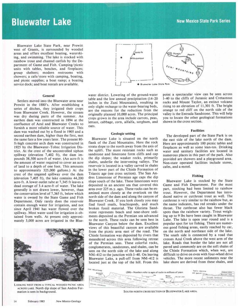
Bluewater Lake State Park. near Prewitt west of Grants, is surrounded by wooded areas and offers excellent boating, waterskiing, and swimming. The lake is stocked with rainbow trout and channel catfish by the Department of Game and Fish. Camping/picnic units with tables, benches, and fireplaces; group shelters; modern restrooms with showers; a cafelstore with camping, boating, and picnic supplies; a boat ramp; a boating servicedock; and boat rentals are available. General Settlers moved into the Bluewater area near Prewitt in the 1880's. After establishing a series of ditches, they irrigated their crops from Bluewater Creek. However. the stream was dry during parts of the summer. An earthen dam was constructed in 1894 at the confluence of Azul and Bluewater Creeks to furnish a more reliable source of water. This dam was washed out by a flood in 1905 and a secondearthen dam, higher than the first, met the same fate a few years later. The present 80ft-high concrete arch dam was constructed in 1925 by the Bluewater-Toltec lrrigation District. At the crest of the uncontrolled siphon spillway (elevation 7,402 lt), the dam impounds 38,500 acre-ft of water. (An acre-ft is the amount of water required to cover an acre of land to a depth of one foot. This amounts to approximately 325,000 gallons.) At the crest of the ungated spillway over the dam (elevation 7,405 ft), the lake contains 44,200 acre-ft. A lower outlet tube at7,345 ft leavesa dead storage of 3.4 acre-ft of water. The lake generally is not drawn lower, however, than the conservation level of 7.365 ft. below which water is owned by the State Game and Fish Department. Only rarely does the reservoir contain enough water for irrigation, and not since April l94l has water flowed over the spillway. Most water used for irrigation is obtained from wells. At present only approximately 3,000 acres are irrigated in the Blue- ztJNt ,4ot)NtAtNs a Bluewolc/ Lot. Slolr Potk water district. Lowering of the ground-water table and the low annual precipitation (14-20 inches in the Zuni Mountains), resulting in only slight recharge to the water-bearing beds, are the reasons for the reduction from the originally planned 10,000 acres. The principal crops grown in the area include carrots, peas, lettuce, cabbage, corn, alfalfa, sorghum, and oats. point a spectacular view can be seen across I-40 to the cliffs of Jurassic and Cretaceous rocks and Mount Taylor, an extinct volcano rising to an elevationof ll,30l ft. The bright orange to red cliff on the north side of the valley is the Entrada Sandstone.This will help you to locate the other geological formations shown in the cross section. Facilities Geologic setting Bluewater Lake is situated on the north flank of the Zuni Mountains. Here the rock strata slope to the north away from the axis of the uplift. The more resistant rocks such as sandstone and limestone form cliffs and cap the dip slopes; the weaker rocks, primarily shales, underlie the intervening valleys. The reservoir is located in a valley carved in shales in the lower part of the Chinle Formation of Triassic age (see cross section). The San Andres Limestone of Permian age caps the dip slopesouth of the lake. Theselimestoneswere deposited in an ancient sea that covered this area over 225 m.y. ago. These rocks can be examined more closely at the overlook on the north side of the dam and along the canyon of Bluewater Creek. If you look closely you may find fossil snails, brachiopods, and much broken fossil material. The Glorieta Sandstone represents beach and near-shore sediments deposited as the Permian sea advanced to the north. These rocks can be seen best in Bluewater Canyon below the dam. Excellent views of this beautiful canyon are available from the picnic area east of the road. The Chinle formation was deposited by rivers that meandered across this area following retreat of the Permian seas. These colorful rocks, conglomerates, sandstones,and shales,can be seen on the north side of the lake and along NM-412 to the junction with I-40. On leaving Bluewater Lake, a pull-off from NM-412 is located just at the top of the hill. From this The developed part of the State Park is on the east side of the lake north of the dam. Here are approximately 100 picnic tables and fireplaces as well as some lean-tos. Drinking water and sanitary facilities are located in numerous places in this part of the park. Also provided are showers and a playground area. Non-state operated facilities include stores, cafes, and a motel. Fishing Bluewater Lake is stocked by the State Game and Fish Department. For the most part, stocking had been limited to rainbow trout. However, the Department has introduced native or cutthroat trout as well. The cutthroat is very similar to the rainbow but, as the name indicates. has red streaks under the throat. The cutthroat also has fewer black spots than the rainbow variety. Trout weighing up to 9 lbs have been caught in Bluewater Lake. The lake is open year round and is a popular spot for ice fishing. There are numerous good fishing areas, easily reached by car, on the north and northeast side of the lake. The south side is connected by a road that crossesAzul Creek above the west arm of the lake. Roads that border the lake are not all paved and commonly are on the soft shalesof the Chinle Formation which, when wet, are difficult to drive on even with four-wheel drive vehicles. The more recent sediments near the lake shore are derived from these shales, and zuN, (200)-Numbers.efer lo ages of rocks in millions of years --.1"" LooKtNc WESTFRoMA TyplcAL wooDED plcNlc AREA AcRossLAKE North dip slope of San Andres Formation is seenin background. February1983 New Mexico Geology R€..h, - ' < - - o - i - . a o - . a LAKE AREA SourH-NoRTHcRosssEcrtoN oF BLUEWATER - - - - - - - ; ofGeology Gallery ovERSHADow DocK Cr-rppsop TRrAsslcFoRMATIoN AREA ATNORTH ENDOFLAKE below the dry crust are saturated with water. Caution should be used in approaching the lake and in driving most of the dirt roads dur! ing or after rain storms. Stephenson-80[[Gtt (conrinued fromp. t 3) Newman's Semi-Weekly, 1881, The Stephenson Mine: Las Cruces, Newman's Semi-Weekly, v. l, no. 10, p. 2, April 20. l88l New Mexico Bureau of Mines and Mineral Resources,various dates, File data, production records, statistics Northrop, Stuart A., 1959, Minerals of New Mexico: Albuquerque, University of New Mexico Press, 665 p Republican, Rio Grande, Las Cruces, 8/l/1885; 12/26/ 1 8 8 5 ;I l / 3 / 1 8 8 7 ; | / ' 1/ 1 8 8 8 ;| / t 4 / 1 8 8 8 Seager, William R., 1981, Geology of Organ Mountains and southern San Andres Mountains. New Mexico: New Mexico Bureau of Mines and Mineral Resources. Mem 36,97 p. Skidmore Papers, no date, Skidmore papers: Las Cruces, New Mexico State University, Rio Grande Historical Society Sprague, J. T., 1858, A memoir upon Stephenson's silver mine, near Fort Fillmore, New Mexico, in the Organ range of mountains, New Mexico: San Marino, California, Huntington Library, no. 1379; Albany, C. Van Benthuysen Printer, original 40 p. U S. General Land Office (G L O ), 1873, Plat and field note, San Augustine lode: U S. General Land Office, Mineral Survey no. 2-New Mexico Wilkinson, Harry G., 1910, Brief history of the Bennett and Stephensonmine in New Mexico and other mines in the Organ district: El Paso, Texas, El Paso Public Library archives, fragment from unknown El Paso news- C sections available Cross The Roswell Geological Society announces the availability of its new Pecos Slope Abo Cross Section. Stretching from De Baca County to Eddy County, New Mexico, this set of N-S and E-W cross sections detail electrical-log and lithologic relationships of this important new play. To our knowledge, the Abo play is the first in which hydrocarbons in economic amounts have been found in nonmarine redbeds. With over 300 producing wells, this Abo play is indeed of major significance. The cross section is available in two scales: l " = 40' at $60.00 per set, and L' : 60' at $40.00 per set. Requests for copies of or information about this cross section can be sent to Roswell Geological Society, P.O. Box ll7l, Roswell, New Mexico 88201. Photo b! Sam Thompson III Muleshoe mound is one of the more spectacular limestone buildups seen in the Lake Valley Formation (Mississippian) along the western escarpment of the Sacramento Mountains in Otero County, New Mexico 1 , 0 O 0f t i n d i a m e t e r ,w a s d e N w % S W % s e c .2 8 , T . l ? S . , R . t 0 E . ) . T h i s b i o h e r m ( r e e | , 3 5 0 f t h i g h a n d posited 5 mi seaward(south) of the shelf edgein water depths up to 100 ft or more-during a relative rise of sea ievel. Note in this northward view that the massive core interfingers downward and eastward with clastic material derived from the core, that this eastern flank facies thins down to approximately 70 ft, and that younger Mississippian units of deep-marine deposits onlapped and buried the bioherm. Various theories of origin consider tlie main biohermal framebuilders to be crinoids, fenestrate bryozoans' filamentous algae (inferred from lime-mud deposits),or some combination Six of the geologistswho have made significant contributions to the study of Muleshoe mound are shown, left to right, in chronological order of their work: l) Arthur L. Bowsher (YatesPetroleum Corporation), who with Lowell R. Laudon (University of Wisconsin, not shown) discovered the mounds while they were establishing the regional stratigraphic framework of the Mississippian in the late 1930's-1940's;2) Lloyd C. Pray (University o1 Wisconsin), who during the late 1940's-1950'smapped the Sacramento Mountains' studied ihe entire stratigraphic r""tion, and diicovered the presenceof fenestratebryozoans in the core facies of the bioherms; 3) William J. Meyers (State University of New York, Stony Brook), who by petrographic analysis and other techniques in the 1970;sdetermined that the bioherms were cemented initially in at least three episodesof fresh-water diagenesis,probably during brief eustatic falls of sea level in late Mississippian time; 4) H. Richard Lane (Amoco Production Company, ResearchCenter), who in the 1970's demonstrated by tracing stratigraphic units and dating them preiisely with conodont zonations that a wedge-on-wedgerelation(Texas ship existidbetween the Lake Vatley shelf margin and the later basin filt; 5) Thomas L. De Keyser Teih University), who in the late 1970's-1980'sdescribedseveralMississippiansectionsin detail, sampled the bio- and lithofacies, traced depositional units, and analyzed mound development; and 6) William D. Jackson (Texas Tech University, graduate student of De Keyser), who recently measured and sampled a detailed section of the Muleshoe mound while dangling from a rope anchored at the topl This group was assembled for the photograph during an international field seminar last March' A field guide for the trip was prepared by Lane and others on p. 115-182 (see p. 143-158 on Muleshoe mound) of: ;,symposium on the environmental setting and distribution of the Waulsortian facies," published jointly by the El Paso Geological Society and the University of Texas at El Paso and edited by Keith Bolton, Lane, and David V. LeMone. In the north Texas area. such bioherms contain sufficient porosity to be important reservoirs of oil and gas. However, thesebioherms in the Sacramento Mountains have been so thoroughly cemented that practiially all of the original porosity has been occluded. The Mississippianreservoirsof southeasternNew Mexico have yielded relatively minor amounts of oil and gas. -Sam ThompsonIII New Mexico Geology February1983 t5


