Document 10907323
advertisement
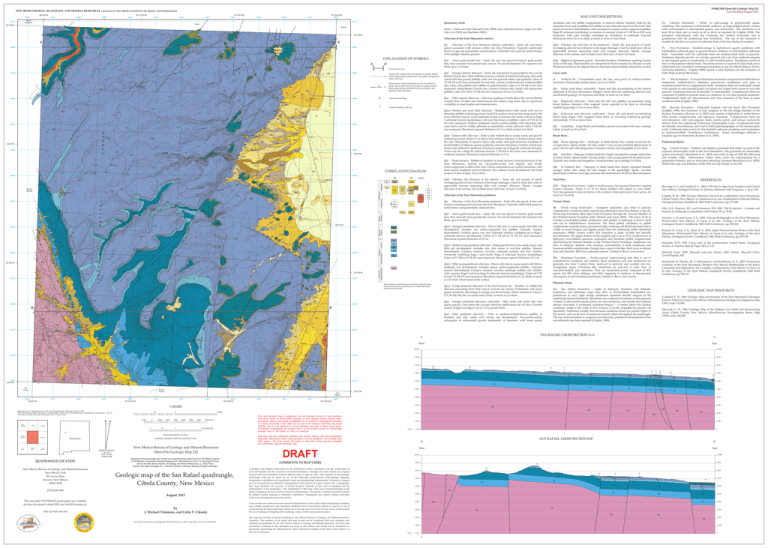
ȱȬęȱȱȱŘřŘ ȱęȱȱŘŖŗŘ NEW MEXICO BUREAU OF GEOLOGY AND MINERAL RESOURCES A DIVISION OF NEW MEXICO INSTITUTE OF MINING AND TECHNOLOGY 108°0'0"W 226000 227000 228000 229000 107°57'30"W 230000 231000 232000 Mount Sedgwick 234000 235000 236000 107°52'30"W 237000 ȱȱ 238000 3891000 Py Pg ^m 2 J ^m ^c 3 Pg Py ^c 4 Py ^m ^c ^m 4141 Qls ^m 24 ^c Qsa Psa af ȱȱ 5 5 4^m ^m 11 ^c ^m ^c 3889000 Qes ^c 18 2 2 Psa Qpy 3 3888000 1 3 3 4 2 Psa Qpy2 Qpy3 Qptf Qptf Qpy2 8 Qpo Qpy2 Qpy3 Qpy1 Psa Psa ^c ^m 14 ^c 2 3 Qca Qca Qca Psa Qpy1 Qpo 2 3886000 2 1 Qpy1 Qpy2 af af Qpy3 Qpy2 Qpo Qpo Qpyt af 20 ^c Qpy2 Qpy ^c 5 Qpy ^m 3 af ^c Qpo Qpy QTg 6 20 af Qpy1 Qpy1 af ^c Qpy1 Qpy1 af 5 Qpo ^m Qpo Qpy1 Qpy2 ^c af Pa 4 Pa Py ^c Psa ^m ^m Pa 3883000 Qatf Xgg 22 Qatf Pg Pa Xgg Qatf Qay 3882000 Xgg 35°2'30"N Qay ^c Qpy ^m Qpy ^c ^m Qpy Qay Psa Qatf Qatf Qca Qay Qatf Qay Pa54 Qay Qatf Qay Qatf ^c ^m Qatf Qaow 5 Pa Qaow J Qca Xgg Xgg Xgg Xgg 6 Pa Qaf 3 Qsa Qst 3 Qa Qsa 4 4 Py 20 10 6 Qaoe 12 af Qay Qay Qaow Qay Qaow Xgg Xgg Qaow Xgg ^c Xgg Qaf Qaf Qaf 108°0'0"W 228000 229000 Qpy1 Qls Qptf Qpy1 Qpy Qpy1 Arrosa Ranch 227000 230000 107°57'30"W 3878000 Qsa Psa 232000 0.5 233000 1000 MOUNT SEDGWICK MILAN 0 234000 107°55'0"W ICE CAVES SAN RAFAEL ARROSA RANCH 2000 3000 4000 5000 6000 0.5 0 7000 FEET 1 KILOMETER CONTOUR INTERVAL 20 FEET GRANTS SE NATIONAL GEODETIC VERTICAL DATUM OF 1929 NEW MEXICO LOS PILARES Magnetic Declination July, 2011 9º 37' 10" East At Map Center QUADRANGLE LOCATION New Mexico Bureau of Geology and Mineral Resources New Mexico Tech 801 Leroy Place Socorro, New Mexico 87801-4796 New Mexico Bureau of Geology and Mineral Resources Open-File Geologic Map 232 Mapping of this quadrangle was funded by a matching-funds grant from the STATEMAP program of the National Cooperative Geologic Mapping Act, administered by the U. S. Geological Survey, and by the New Mexico Bureau of Geology and Mineral Resources, (L. Greer Price, Director and State Geologist, Dr. J. Michael Timmons, Geologic Mapping Program Manager). Geologic map of the San Rafael quadrangle, Cibola County, New Mexico [575] 835-5490 August, 2012 This and other STATEMAP quadrangles are available for free download in both PDF and ArcGIS formats at: http://geoinfo.nmt.edu by J. Michael Timmons, and Colin T. Cikoski New Mexico Bureau of Geology and Mineral Resources, 801 Leroy Place, Socorro, NM 87801 ǰȱǯǰȱ £ǰȱǯȱǯȱȱǯȱȱǰȱǯȱǯǰȱŘŖŖřǰȱ£ȱ ȱȱȱȱǰȱȱ ȱ¡DZȱȱȱȱ£ȱ ȱȱȱȱȱ¡ȱȱ¢ǰȱ ȱ¡DZȱȱȱȱ al. eds., Geology of the Zuni Plateau, Geological Society Guidebook, 54th Field Conference, pp 109-117. Paleozoic Strata ȱ ȱ ȱ ȱ Ȯȱ Ȭȱ ȱ Ȭ¢ȱ ȱ ȱ ǯȱ ȱ ȱ ȱ ȱ ȱ Ȭȱ ȱ Ȭǯȱ ȱ ǰȱ pinkish-tan to very- light orange sandstones represent discrete tongues of the ¢ȱȱǯȱȱȱȱȱȬȱȱęȬǰȱ ȱȱȱĵȱǰȱȱȬǰȱȱ¢ȱȱȱ ȱ Ȭǯȱ ȱ ȱ ȱ ȱ ŝȱ Ȯȱ Şȱ ȱ ȱ ȱ ȱ sandstone, visible in the walls of Zuni Canyon, is locally mappable but pinches out repeatedly. Additional variably discontinuous sandstone lenses are present higher in ȱȱȱȱȱȱȱȱȱȱ¢ȱȱȱǯȱ The top of the formation is a regional unconformity, paleokarst development at this ¢ȱȱȱȱǻĴǰȱŗşŞşǼǯȱ ȱȱ Goddard, E. N., 1966, Geologic Map and Sections of the Zuni Mountains Fluorspar ǰȱȱ¢ǰȱ ȱ¡ǰȱȱȱǰȱȱ ȬŚśŚǰȱȱŗDZřŗǰŜŞŖǯ ¡ ǰȱ ǯȱ ǯǰȱ ŗşŞŜǰȱ ȱ ȱ ȱ ȱ ȱ ȱ ȱ ȱ ȱ Areas, Cibola County, New Mexico, Miscellaneous Investigations Series, Map I-1595, scale 1:62,500. A’ 235000 East 9,000 9,000 Psa Pg ^u Qpy3 6,000 3877000 Psa Pg Py Psa Psa ^u Psa Psa Psa Psa Pg Py Pg ^u ^u 7,000 Qa Psa Psa Py Py Pa ^u Pg Pg Py Py Psa Psa Pg Psa Qbc Qsa Psa 237000 107°52'30"W Pa 5,000 Pa Pa 35°0'0"N Py Py 5,000 Pa Pa 4,000 3,000 Xgg Xgg Xgg 2,000 Xgg Xgg 2,000 Xgg 1,000 1,000 M.S.L. 0 (ft) After this map has undergone scientific peer review, editing, and final cartographic production adhering to bureau map standards, it will be released in our Geologic Map (GM) series. This final version will receive a new GM number and will supercede this preliminary open-file geologic map. 0 SAN RAFAEL CROSS SECTION B-B’ B B’ West DRAFT East 10,000 COMMENTS TO MAP USERS 10,000 9,000 A geologic map displays information on the distribution, nature, orientation, and age relationships of rock and deposits and the occurrence of structural features. Geologic and fault contacts are irregular surfaces that form boundaries between different types or ages of units. Data depicted on this geologic quadrangle map may be based on any of the following: reconnaissance field geologic mapping, compilation of published and unpublished work, and photogeologic interpretation. Locations of contacts are not surveyed, but are plotted by interpretation of the position of a given contact onto a topographic base map; therefore, the accuracy of contact locations depends on the scale of mapping and the interpretation of the geologist(s). Any enlargement of this map could cause misunderstanding in the detail of mapping and may result in erroneous interpretations. Site-specific conditions should be verified by detailed surface mapping or subsurface exploration. Topographic and cultural changes associated with recent development may not be shown. 9,000 Psa Psa 8,000 Pg 8,000 Pg Xgg Psa Py Py 7,000 ^u ^u Pg Psa Pa Pg Pa Py 6,000 Psa Pa 5,000 4,000 ^u Psa Pg 6,000 Pa Py 5,000 Pa 4,000 Xgg 3,000 Xgg Xgg 2,000 7,000 Py Xgg 3,000 M.S.L. Qa Pg Xgg Cross sections are constructed based upon the interpretations of the author made from geologic mapping, and available geophysical, and subsurface (drillhole) data. Cross-sections should be used as an aid to understanding the general geologic framework of the map area, and not be the sole source of information for use in locating or designing wells, buildings, roads, or other man-made structures. The map has not been reviewed according to New Mexico Bureau of Geology and Mineral Resources standards. The contents of the report and map should not be considered final and complete until reviewed and published by the New Mexico Bureau of Geology and Mineral Resources. The views and conclusions contained in this document are those of the authors and should not be interpreted as necessarily representing the official policies, either expressed or implied, of the State of New Mexico, or the U.S. Government. Pa 6,000 Pg Py 4,000 238000 This draft geologic map is preliminary and will undergo revision. It was produced from either scans of hand-drafted originals or from digitally drafted original maps and figures using a wide variety of software, and is currently in cartographic production. It is being distributed in this draft form as part of the bureau's Open-file map series (OFGM), due to high demand for current geologic map data in these areas where STATEMAP quadrangles are located, and it is the bureau's policy to disseminate geologic data to the public as soon as possible. Pa ^u Psa Pg ^c Qsa 236000 ^u Pg Psa Qpy1 Psa 7,000 af Qptf Qptf Qpo 8,000 Psa Qpy 1 MILE GRANTS 1 PAXTON SPRINGS 1000 Munsell Color. 2009. Munsell soil-color charts, 2009 edition. Munsell Color, Grand Rapids, MI. SAN RAFAEL CROSS SECTION A-A’ 3,000 0 Ĵǰȱ ǯǯȱ ŗşŞśǯȱ ȱ ȱ ȱ ȱ ȱ ȱ ǯȱ ȱ Society of America Special Paper 203, p. 1-21. ^m Moenkopi Formation – Poorly-exposed slope-forming unit that is red to reddish-brown mudstone and siltstone. Basal mudstones and silty mudstones are generally less than 5 meters thick, weak-red to dark-red, and weather into low, unvegetated slopes. Overlying silty sandstones are pale-red in color, thin- to ¢ȬȬǰȱ ȱ ǯȱ ¢ȱ ȱ ¢Ȭǰȱ ȱ ȱ ŞŖƖȱ ĵȱ ȱ ŘŖƖȱ ǰȱ ǰȱ ȱ ȱ ȱ ȱ Ȭȱ ȱ ęȬǰȱ ȬȱȱȬȱǯȱȱȱ^u in cross section. Xgg 1 ǰȱǯȱǰȱǯȱǯǰȱǰȱǯȱǯǰȱŘŖŖřǰȱȱ¢ȱȱȱȱȱ ǰȱ Ȭȱ ȱ ¡ǰȱ ȱ ȱ ȱ ǯȱ ǯǰȱ ¢ȱ ȱ ȱ ȱ Plateau, Geological Society Guidebook, 54th Field Conference, pp 219-229. 10,000 8,000 1:24,000 Base map from U.S. Geological Survey 1957, from photographs taken 1955, field checked in 1957. 1927 North American datum, New Mexico coordinate system, central zone (Transverse Mercator). Reprojected to UTM projection -- zone 13. 1000-meter Universal Transverse Mercator grid, zone 13, shown in blue. ǰȱǯȱǯȱȱǰȱǯȱǯǰȱŘŖŖřǰȱȱ¢ȱȱȱȱǰȱ Ȭȱ ȱ ¡DZȱ ȱ ȱ ȱ ǯȱ ǯǰȱ ¢ȱ ȱ ȱ ȱ ǰȱ Geological Society Guidebook, 54th Field Conference, pp 245-262. Qsa Qsa Los Pilares 231000 ǰȱ ǯ ǯǰȱ ǰȱ ǯǯǰȱ ȱ ǰȱ ǯǯȱ ŗşŜśǯȱ ȱ ȱ £ȱ Ȭȱ ȱ ȱ ȱ £ȱȱȱǯȱȱȱşşǰȱǯȱŝŚȬŞŘǯ 10,000 Qpy1 Qpo Qpo Qptf Qptf af Qpy Qpy1 af Qpy1 af 6 Ice Caves 226000 Qpy1 Qpy1 4 Qay Xgg Qpy3 ^c Qay Xgg Qsa Qpy1 Qpy1 Qpy1 Qpy1 2 Xgg ^c Chinle Group Undivided – Variegated mudstones and white to pale-tan ȱȱ¢ȱȱĴȱȱȱĴȱȱDzȱȱ Shinarump Formation, Bluewater Creek Formation through the Sonsela Member of ȱ ęȱ ȱ ȱ ǻȱ ȱ ȱ ȱ ŘŖŖřǼǯȱ ȱ ȱ ȱ ŗśȬŗŞȱ ȱ includes cross-bedded pebbly sandstones, with pebbles of dark-gray to brown chert and red to reddish-brown mudstones. The basal pebbly sandstone to pebble conglomerate typically forms a prominent ledge overlying soft Moenkopi strata that is visible on aerial imagery and slightly grayer than the underlying redder Moenkopi ǯȱ ȱ ȱ ȱ ȱ ȱ ȱ ȱ ȱ ȱ ¢ȱ discontinuous. The upper portion of this mapped unit is up to 20 m of pale brown to Ȭ¢ȱ Ȭȱ ĵȱ ȱ ȱ ȱ ȱ ȱ ȱ ȱ ȱ ȱ ȱ ȱ ęȱ ȱ ǯȱ ȱ ȱ thin- to medium- bedded, with common cross-bedding in both sandstones and limestone pebble conglomerates, though more vague in the later. Both occur as tabular ȱȱǯȱȱȱȱǯȱȱȱȱ^u in cross section. Qpy1 Qpy1 Qbc Psa ^m 20 Xgg Qsa Qpy1 Qaow Xgg Qpy ^m af Xgg Qca Psa Qsa Qaf ĴǰȱǯȱǯǰȱŗşŞşǰȱȱȱȱȱȱȱǰȱ Cibola County, New Mexico: in Anderson et al. eds., Southeastern Colorado Plateau, ȱ¢ȱǰȱŚŖȱȱǰȱȱŗŝŝȬŗŞŖǯ West Qptf Qpy3 Qa 6 Qaf Qaf ǰȱǯȱǯȱȱǰȱǯȱǯǰȱŗşŞŘǰȱȬȱȱȱȱȱȱȱ New Mexico: Geological Society of America Abstarcts with Programs, v. 14, p. 304. Triassic Strata Qpyt Young piedmont alluvium of the Trail Canyon fan – Boulder- to cobble-rich alluvium emanating from Trail Canyon. Gravels are mainly of limestone with lesser ĵȱǰȱȱȱȱ£ȱ ǯȱ¡ȱȱȱȱ ȱ ǻŝǯśȱȱśȦŚǼȱ¢ȱęȱȱȱǯȱ¢ȱȱȱȱŘȱȱǯ A Qpy3 af Qaoe QayQaoe Qa ȱ ȬȱȱȮȱȬȱȱȬ¢ǰȱęȬȱȱȱ Cerrito Colorado. Thinly (1 to 10 cm thick) bedded with planar to wavy beds. ¢Ȭęȱȱ¡ȱȱ¡ǰȱ ȱȱ ȱȱȱȱŘȱȱǯȱȱ much as 3 m thick. Qpy Younger piedmont alluvium, undivided – Silty sands and sandy silts with sparse gravels. Used where the younger alluvium subdivisions are not clear. Consists mainly of Qpy2 and Qpy3. Up to 1 m or greater thick. Qpy Qsa Qa Pa REFERENCES Qbc Psa Xgg Travertine ¢ŗȱ ȱ¢ȱȱȱȮȱ ȱ¢ȱęȱȱȱȱ ȱĴȱȱ moderate soil development. Includes sparse matrix-supported pebbles. Typically ȱ ǻǼǯȱ ȱ ȱ ¢Ȭęȱ ȱ ȱ ȱ ǰȱ with common Stage I and local Stage II carbonate horizon morphology. Colors of 5 YR 4/3 and 7.5 YR 4/3 were measured. Maximum exposed thickness of 1 m, likely as much as 2 m thick where found at the surface. Qptf 2 Qpy3 9 ȱ ȱ ȱ Ě ȱ Ȯȱ Ȭ¢ȱ ȱ ȱ ȱ Ě ȱ ¢ȱ ȱ ȱ ¢ȱ ȱ ęȱ ȱ ȱ ȱ ȱ ȱ ȱ ǯȱ ǰȱ ¢Ȭęȱ phenocrysts of olivine. Exact age uncertain, but constrained to 50-130 ka. Base unexposed. 3879000 Qst Qay Xgg Granitic Gneiss – Foliated calc-alkaline granitoids that make up most of the exposed metamorphic rocks in the Zuni Mountains. The granitoids are dominately ĵȱ£ȱǻȱȱǯǰȱŘŖŖřǼȱȱ¢ȱȱȱȱŗŜśśȱȱǻ ȱ ȱ ǰȱ ŗşŞŘǼǯȱ ȱ ȱ ȱ ȱ ȱ ȱ £ȱ ¢ȱ ȱ penetrative foliation and an associated stretching lineation (Strickland et al., 2003). ȱȱȱȱȱȱȱȱȱ¢ȱȱȱǯ £ȱ ȱĚ ȱȮȱȬ¢ȱȱȱȱĚ ȱ¢ȱȱ¢ȱ¢ȱȱęȱ ȱȱ¢ǯȱȱǻȱŗƖǼȱęȱǻȱŗȱȱǼȱȬȱ¢ǯȱ Typically rare vesicles and amygdules. Unexposed base. Up to perhaps 5 m thick. Qpo Older piedmont alluvium – Pale- to medium-reddish-brown pebbles to boulders and silty sands with strong soil development. Very-poorly-sorted, ȱ ȱ ȱ ȱ ¢ȱ ȱ ǰȱ ȱ ȱ ĵȱ Qptf Qsa Proterozoic Rocks Qbc Qbc Psa 20 Qsa 30 Qay Qca *b B' Qa 6 Qaoe Qay Qaow Pa af Psa ^c ^c Psa Qsa Qaoe 2 34 Qsa Qst Qaoe Qaow Qay Qaow QaowQay Qaf Pa Xgg Py Qpy Qsa ^m 3 Xgg 3878000 J Qpy Qls 21 ȱ ¡ȱ ȱ Ě ȱ Ȯȱ Ȭ¢ȱ ȱ ȱ ¢ȱ Ě ȱ ¢ȱ ȱ ¢ȱ ¢ȱ ęǯȱ ȱ ǻȱ ŗƖǼȱ ęȱ ǻȱ ŗȱ ȱ Ǽȱ ȱ ¢ȱ ȱ green olivine and white plagioclase. Common vesicles and amygdules. 0-4 m thick. ¢Řȱ ȱ¢ȱȱȱȮȱȬ¢Ȭ ȱęȬ¢ȱȱ ȱ Ĵȱ ȱ ǯȱ ȱ ǰȱ ȱ ȱ ȱ ¢Ȭęȱ ǯȱ ȱ ǻǼǯȱ ȱ ȱ ¢Ȭęȱ ȱ ȱ ȱ ȱ ǰȱ commonly exhibiting Stage I and locally Stage II carbonate horizon morphology. Colors of 7.5 YR to 10 YR 4/2 were measured. Maximum exposed thickness of 1.1 m. 3880000 Qpy1 Qpy3 Qca Qaow Xgg Pa Pg Qptf Qpy1 ^c 6 Qca ȱĚ ¢řȱ ȱȱȱȮȱ ȱ¢ȱęȱȱȱȱ ȱĴȱȱ ǯȱ ȱ ȱ ¡Ȭȱ ęȱ ǯȱ ¢¢ȱ ȱ ǻǼǯȱ ȱ ȱ ¢ȱ ęȱ ȱ ǰȱ ¡ȱ ȱ ȱ ȱ ȱ carbonate horizon development. Colors of 5 YR 6/4 to 7.5 YR 5/3 were measured. Maximum exposed thickness of 65 cm. Qpy3 4 11 ȱ ȱȮȱȱȱȱ¢ȱȱȱ ȱȱ ǯȱ ¢ȱȱȱȱřŖȱȱǯ Qpf Active gully-mouth fans – Sand, silt, and rare gravel of historic gully-mouth fans. Fans emanate from present-day arroyos. No soil development. No exposure, but likely up to 1 m thick. ^m lPb Bursum Formation – Originally lumped with the basal Abo Formation ǻĴǰȱ ŗşŞşǼǰȱ ȱ ȱ ȱ ȱ ȱ ȱ ȱ ȱ ȱ ȱ ȱ ȱ Bursum Formation (Krainer et al, 2003) and consists of light-pink to redish-brown lithic arenite conglomerates, and light-gray limestone. Conglomeratic beds are very-immature with very-angular clasts, poorly-sorted, and almost exclusively derived from the underlying Proterozoic metamorphic rocks. Conglomerate beds ȱ¢ȱȱȱȱȱęȱ¢ȱȱȱȱ rocks. Carbonate beds tend to be thin-bedded carbonate mudstone and wackestone to medium-bedded fossiliferous wackestones. Fossil assemblages indicates a Virgilian age for these beds (Krainer et al., 2003). Qca Colluvium and alluvium, undivided – Sand, silt, and gravel accumulating below steep slopes. Only mapped where thick or concealing underlying geologic relationships. 0-2 m or more thick. af Qptf 2 ^m Qls 85 QTg Qpy3 Psa ^c Qay Qay Qca Qca Qaow Qaow Qay QayQaow Qaow Qaow Qaow Qptf Qptf af af af 2 Py Xgg Xgg Qaow af af Qca Qay af Xgg Xgg Qca Qay Xgg Qca Qpo Pa Abo Formation – A mixed siliciclastic formation composed of reddish-brown mudstones, reddish-brown siltstones, grayish-red sandstones, and pale- to moderate-redish brown conglomeratic beds. Sandstone beds are moderately sorted ȱȱȱȬȱȱȱȱ£ȱȱȱȱȱ¢ȱęȱ grained. Sandstone beds are moderately- to thick-bedded. Conglomeratic beds are ȱȱȱȱȱȱȱȱȬȱȱ¢ȬęȬȱǯȱȱ Conglomeratic beds are discontinuous and form channels at the base of some ȱȱǻĴǰȱŗşŞşǼǯ Qsa Slopewash alluvium – Sand and silt with rare pebbles, accumulating along broad shallow channels. Only mapped where expected to be thick or obscuring underlying geology. 0-1 m or more thick. Qp Alluvium of the Zuni Mountain piedmont – Sand, silt, and gravel of fans and terraces extending eastward from the Zuni Mountains. Typically subdivided based on sedimentary and geomorphic characteristics. Qbc Qst Qaow Qaoe *Basalt-alluvium correlations based on imprecise radiometric ages and age estimates from soil development, not field relationships, and hence are not certain. af ^m 2 ^m 8 Xgg 3879000 ^c Qptf 13 Qaow Qaow Qay Pa Qaow Qaow Qatf af Qay af Qaow af af af Qaow Qaow Qaow Qaow 3880000 Qptf ^c Qay Qaow af 53 Qaow af af Qay Pa Qbz ¢ȱ ȱ ȱ Ȯȱ Ȭȱ ȱ Ȭ ȱ ĵȱ ȱ ȱ interbedded yellowish-gray to grayish-brown, medium- to thin-bedded carbonate beds. Associated with the carbonate beds are medium-thick beds of gypsum. ȱȱȱęȬȱȱ¢Ȭęȱȱȱ¢ȱȱ¢Ȭȱ to sub-angular grains to moderately- to well-rounded grains. Sandstones consist of thin- to thick-planar tabular beds. The entire section is exposed at Gallo Peak and is ȱȱřȱȱȱȱĴȱȱǰȱȱȱǰȱǰȱ ȱ¢ȱǯȱȱĴȱǻŗşŞşǼȱȱȱȱȱȱȱȱȱ ȱȱȱȱřŞŖȱǯ Qes Eolian sand sheet, undivided – Sands and silts accumulating on the eastern piedmont of the Zuni Mountains. Mapped where obscures underlying alluvial units and bedrock geology. No exposure, but likely as much as 2 m thick. Alluvium of the Zuni Mountains piedmont ^m Qay Qaow Qaow 35°2'30"N ^c 3881000 10 Qca Pa Qay ^m ^m ^m Psa Pg Qbp Qpbf Qsa Qca Qls ^m ^c Psa 8 3882000 Qsa ^m ^c Py Qay Qpy1 Psa Qsa ^m Pg Py Qpy3 Qpyt Qpy2 ^c Qpy af ^m ^c 10 Py Pg af Psa Psa Pg Xgg Qay 35°0'0"N ^c ^c Psa 42 Qpf Qatf Qatf 3877000 Psa Qa Qpy Psa Qpy Qpy Psa Psa Qa Pa Qay af Xgg ^m Qpy1 14 Pa Qay Qatf Qptf ȱ ȱ ȱ Ȯȱ Ȭȱ ȱ Ȭȱ ȱ ¢Ȭȱ ĵȱ ǯȱȱȱȱ¢ȱȬȱȱȬȱĵȱǰȱ with well-rounded to sub-rounded grains, and well-sorted. The sandstone is at ȱ řŖȱ ȱ ȱ ȱ ȱ ȱ ȱ ŜŖȱ ȱ ȱ ȱ ȱ ¢ȱ Ĵȱ ǻŗşŞşǼǯȱ ȱ formation intertongues with the overlying San Andres Formation and is gradational with the underlying Yeso Formation. The top of the formation is ȱ¢ȱȱęȱȱȱȱȱȱȱȱȱǯ ȱ ęȱ ęȱ Ȯȱ ȱ ǰȱ ǰȱ ¢ǰȱ ȱ ȱ ȱ ęȱ ȱ ǯȱ¢ȱȱǯȱȱȱŜȱȱǯ Qatf Tributary fan alluvium of the interior – Sand, silt, and gravels of small, overlapping alluvial fans tributary to the larger drainages. Used for small fans with no appreciable features separating older and younger alluvium. Mainly younger alluvium at the surface, and includes local colluvium. At least 3 m thick. af Qpf 6 15 50 Qay Xgg B 3 2 Qatf Qatf Xgg 30 Pa 55 Qay Qaow Qay Py 3883000 ^c ^c ^m Qaow Xgg Psa 15 Pa ^c Qpy1 Psa 8 Pa Grants SE Qpf Psa 4 50 Xgg 5 af af af Qpy Qpy1 Psa *b Xgg Qatf 3881000 Pg 6 Cover units Qpy1 ^c Pa Qes QTtr ^c ^c Pa Qpf Qpf 8 2 Qaf basalts* af ^c Py 8 12 af Qpf Qpf ^c Py 3884000 Mesozoic Triassic Pg Py Qp Tertiary Pliocene 3884000 Qa af Qpo ^m Qsa Qpy1 Qpy1 af Qpy3 Qpy3 3885000 Qpy3 Qpy1 af Qpy 10 Py 6 CORRELATION DIAGRAM Qes Qpy2 Qpy1 ^m 3 3885000 Pg Qpy2 Qpy3 Qpy3 Qpy1 Qay Younger interior alluvium – Sand, silt, and gravel of and graded to the current ȱ¢ȱĚǯȱȱȱȱ¢ǰȱȱȱȬ ȱ¢ȱ¢Ȭȱ ¡Ȭȱęȱȱǰȱ ȱȱęȬȱęȱȱĵDzȱȱȱ 7.5 YR 3/2 to 4/3 were measured. On east side, consists of yellowish-red weakly-bedded ¢ȱǰȱ ȱȱȱȱȱDzȱȱȱśȱȱŚȦŜȱȱśȦŜȱ ȱ ǯȱȱȱ¢ȱ¡ǰȱȱȱ Ȭ¢ȱǰȱ ȱȬęȱ DzȱȱȱśȱȱȱŝǯśȱȱŚȦŚȱ ȱǯȱŖǯśȱȱŗǯśȱȱǯ Qst Strath terraces – Pebbles to boulders of strath terraces overlying bedrock in the Zuni Mountains. Gravels are very-poorly-sorted and angular, and locally ¡ȬȱȱȱĚ ȱǯȱȱȱȱ¢ȱǰȱ ȱ ȱĵȱȱȱȱǯȱȱȱȱȱǰȱȱȱ projects to that of Qaoe. 0-2 m thick. Qpy2 Qpo Qptf QTg High-level piedmont gravels – Rounded boulders of limestone overlying Triassic rocks on hill tops. These boulders are interpreted to be the remains of a Pliocene or early Pleistocene terrace or fan deposit that has since been almost entirely removed by erosion. Qpy3 Psa Qpyt 3886000 Qpy2 35°5'0"N 20Qptf Py 3 af Qpy2 Qpo Qptf ^c Qpy3 Qpo Qpy1 Qaf Active gully-mouth fans – Sand, silt, and rare gravel of historic gully-mouth fans. Fans emanate from present-day arroyos. No soil development. No exposure, but likely up to 1 m thick. ȱ ȱȱȱȮȱȱȱȱȱ ȱǰȱǰȱȱȱ underlying terrace treads 5-7 m above local streams tributary to Bonita Canyon from ȱǯȱ¢ȱȱȱ¢¢ȱ¢ȱǰȱ ȱȱȱȱȱ ȱȱȱǰȱĵȱǰȱȱȱǯȱȱȱȱȱ ȱȱęȱ¢ȱȱȱ£ȱȦȱȱȱȱƸȱȱ£ǯȱ Active soil has a Stage III carbonate horizon. 5 YR 4/4 to 6/6 colors were measured in unaltered material. Maximum exposed thickness of 7 m. Qpf Qpy3 Psa ^m Qpy2 Qpy1 Psa Qptf Qpy Qca Qls Qls Qpy1 Psa Psa 35°5'0"N af Psa ^m 5 2 Qpy3 Qptf Tributary fan alluvium of the piedmont – Sand, silt, and gravels of small, overlapping alluvial fans tributary to the larger drainages. Used for small fans with no appreciable features separating older and younger alluvium. Mainly younger alluvium at the surface, and includes local colluvium. At least 3 m thick. ȱ ȱ ȱ ¡ȱ ȱ ȱ Ȯȱ Ȭ ȱ ¢ȱ ȱ ȱ ȱ ȱ abundant pebbles underlying terrace treads 2-4 m above local streams along and to the west of Bonita Canyon. Axial sediments mainly of massive silty sands with up to Stage ȱȱ£ȱ¢ǰȱ ȱȱȱȱȱDzȱȱȱśȱȱŚȦřȱȱ śȦŚȱ ȱ ǯȱ ȱ ȱ ¢ȱ ȱ ȱ ȱ ȱ ¢ȱ ȱ¡ȱȱȱȱȱDzȱȱȱ¢ ȱǰȱśȱȱŚȦŜǰȱ was measured. Maximum exposed thickness of 1.1 m, likely at least 4 m thick. 3887000 Qpy2 Qa Alluvium of the Zuni Mountain interior, undivided – Sand, silt, and lesser gravel associated with streams within the Zuni Mountains. Typically subdivided based on age and geomorphic characteristics. Undivided unit used for small streams with multiple subunits present. Inclined bedding with dip Qpy1 3 ^c Alluvium of the Zuni Mountains interior Qao Older interior alluvium – Alluvium grading to levels above the current Bonita ¢ȱ Ěǯȱ ȱ ȱ Ȧ¡ȱ ȱ ȱ ȱ ǰȱ ȱ ȱ ęȱ variability in tread heights and characteristics. Horizontal bedding Qpy2 Qpy1 2 ? Normal fault with bar-ball placed on the downthrown ǯȱȱȱȱ ȱȱȱȱǰȱȱ ȱ¡ȱȱĴȱ ȱǰȱȱ ȱ ȱǯ Qpy3 Qpy1 10 ? Contact line is solid where the location is certain, dashed ȱ¡ǰȱĴȱ ȱǰȱȱ where uncertain. Qpo Qpy1 ^m ȱȱ eo Qpy Qpy3 A' af af Pg 3 J : Qca 38 2af J ^c ^c ^m 2 Paxton Springs Qptf Qptf 6 2 3889000 3887000 A ^c Pg 2 3890000 ^m Qatf 3888000 J A' ^c 8 Psa 4 10 Qbp Qes QTtr ^c ^c 5 af af ^m Qls ^c Qls 6 ^m ^c ^m Psa Qptf Qao 3890000 Psa Psa Psa af af ^c ^m ^c 35°7'30"N af af ^m ^c (Note – Colors are after Munsell Color (2009) and carbonate horizon stages are after ȱȱǯȱǻŗşŜśǼȱȱĴȱǻŗşŞśǼǯǼ Quaternary Pleistocene Holocene A ^c ^m Pg ^m Psa ^c Psa ^m Qpy ^m Qca Qbz Pg Grants Py Qpy Qay Psa Paleozoic Pennsylvanian Permian 35°7'30"N sandstone and rare pebble conglomerate, as massive-tabular bouldery beds by the mountain front, and as pebbles and cobbles in rare channels away from the front. Silty sands are massive (bioturbated), with uncommon to sparse matrix-supported pebbles. ȱȱȱ¢ȱȱȱȱǯȱȱȱśȱȱśȦŚȱȱŞǯśȦŘȱ ȱ measured, with color strongly controlled by abundance of carbonate. Exposed thicknesses from 0 to 5 m, likely as much as 10 m or more thick. Quaternary units Milan Proterozoic Paleoproterozoic 3891000 107°55'0"W 233000 Xgg Xgg 2,000 1,000 1,000 0 (ft) 0 0
