Science
advertisement
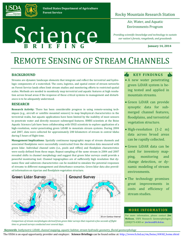
United States Department of Agriculture Forest Service Science Rocky Mountain Research Station Air, Water, and Aquatic Environments Program Providing scientific knowledge and technology to sustain our nation’s forests, rangelands, and grasslands B R I E F I N G January 14, 2014 REMOTE SENSING OF STREAM CHANNELS BACKGROUND Streams are dynamic landscape elements that integrate and reflect the terrestrial and hydrologic components of a watershed. The costs, logistics, and spatial extent of stream networks on Forest Service lands often limit stream studies and monitoring efforts to restricted spatial scales. Methods are needed to seamlessly map terrestrial and aquatic features at high resolution across broad areas if the response of these critical systems to management and disturbances is to be adequately understood. RESEARCH Research Activity: There has been considerable progress in using remote-sensing techniques (e.g., aircraft or satellite mounted sensors) to map biophysical characteristics in the terrestrial realm, but aquatic applications have been limited by the inability of most sensors to penetrate water and directly measure submerged features. RMRS scientists at the Boise Aquatic Sciences Lab have been collaborating with USGS scientists to explore application of a high-resolution, water-penetrating green LiDAR to mountain stream systems. During 2004 and 2007, data were collected for approximately 200 kilometers of stream in central Idaho during 5 hours of flight time. Management Implications: Spatially continuous topographic maps of stream channels and associated floodplains were successfully constructed from the elevation data measured with green lidar. Individual channel units (i.e., pools and riffles) and floodplain characteristics were easily defined from these maps. Repeat sampling of the same stream in 2004 and 2007 revealed shifts in channel morphology and suggest that green lidar surveys could provide a powerful monitoring tool. Channel topographies are of sufficiently high resolution that dynamic flow and substrate characteristics can be modeled to simulate the potential responses of streams to different management and disturbance scenarios. Green lidar data also provided information on riparian and floodplain vegetation structure. KEY FINDINGS A new water penetrating green LiDAR system is being tested and applied in mountain streams. Green LiDAR can provide synoptic data for submerged channel features, floodplains, and terrestrial vegetation structure. High-resolution (1-2 m) data across broad areas can be rapidly collected. Green LiDAR data can be used for inventory mapping, monitoring and change detection, or dynamic modeling of stream environments. The technology promises great improvements in costs and efficiency of stream studies. MORE INFORMATION Comparison of stream morphologies derived from green lidar surveys that required a few seconds of flight time vs. ground surveys conducted over several days. For more information, please contact Jim McKean, USFS Research Geomorphologist, (208)373-4383 or jmckean@fs.fed.us. Keywords: bathymetric LIDAR, channel mapping, aquatic habitat, stream hydraulic geometry, fluvial geomorphology The USDA is an equal opportunity provider and employer. Science Briefings can be found online at: http://www.fs.fed.us/rm/boise/AWAE_home.shtml


