cfakepathriversandcoastssummary-091003065851
advertisement
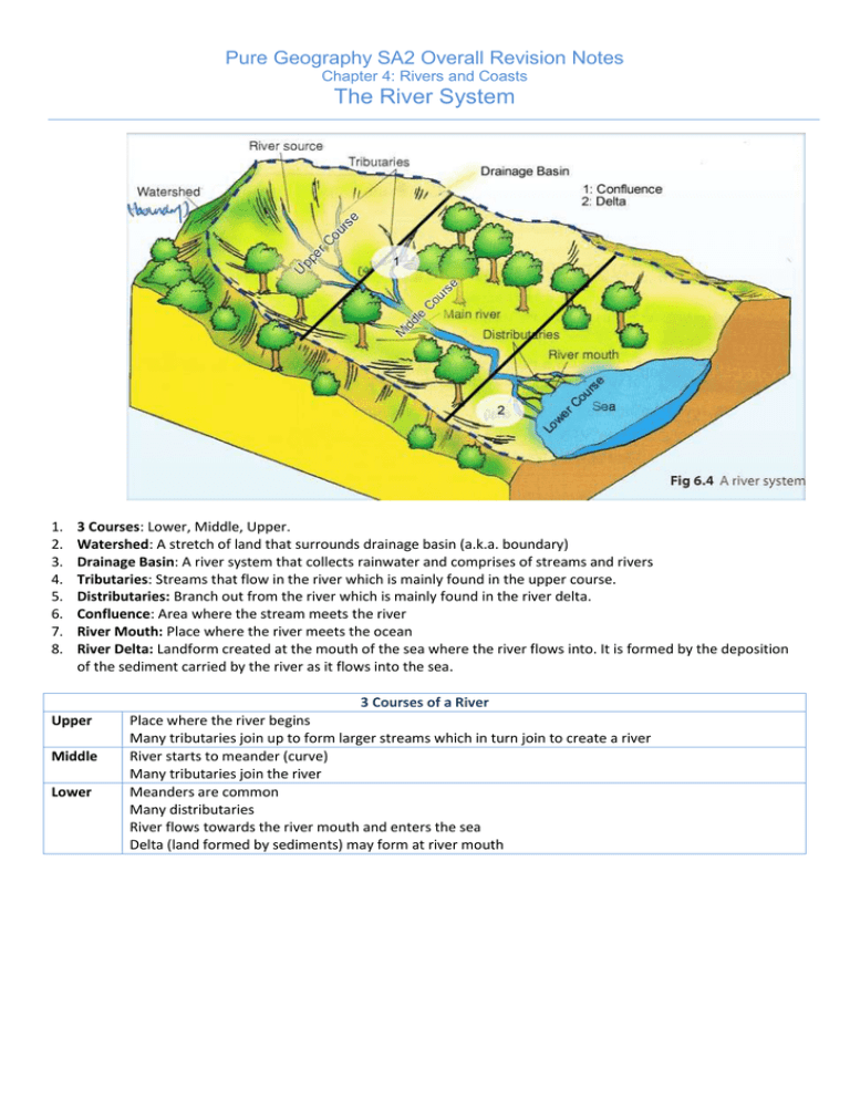
Pure Geography SA2 Overall Revision Notes Chapter 4: Rivers and Coasts The River System 1. 2. 3. 4. 5. 6. 7. 8. 3 Courses: Lower, Middle, Upper. Watershed: A stretch of land that surrounds drainage basin (a.k.a. boundary) Drainage Basin: A river system that collects rainwater and comprises of streams and rivers Tributaries: Streams that flow in the river which is mainly found in the upper course. Distributaries: Branch out from the river which is mainly found in the river delta. Confluence: Area where the stream meets the river River Mouth: Place where the river meets the ocean River Delta: Landform created at the mouth of the sea where the river flows into. It is formed by the deposition of the sediment carried by the river as it flows into the sea. Upper Middle Lower 3 Courses of a River Place where the river begins Many tributaries join up to form larger streams which in turn join to create a river River starts to meander (curve) Many tributaries join the river Meanders are common Many distributaries River flows towards the river mouth and enters the sea Delta (land formed by sediments) may form at river mouth Pure Geography SA2 Overall Revision Notes Chapter 4: Rivers and Coasts Factors affecting River Speed and Volume Gradient Roughness of River Channel Wetted Perimeter Factors affecting Speed of water in River Definition High Speed / Volume Low Speed / Volume How steep a river is. River is steeper (usually at River is gentler (lower course) upper course) How rough a river channel is Fewer obstacles More obstacles More friction (affected by obstacles in river) Smoother channel Reduced speed Faster Area in contact with the river. Shape of river channel affects the wetted perimeter (Length and Breadth in contact with the river) Factor Permeability of Rocks Vegetation Cover Climate Size of Drainage Basin A smaller wetted perimeter Lesser friction Faster A larger wetted perimeter More water More friction Slower Factors affecting Volume of water in River Definition High Speed / Volume Permeability is the ability of Permeable rocks (holds more rocks being able to hold water) Lesser surface runoff water Vegetation: Plants at the Sparse vegetation Less side of the river rainwater infiltrate ground More surface runoff Large volume How rainfall / temperature Hot / Wet (High Evaporation) affects the river High volume of water Wet/dry weather Water level fluctuates (drop/unstable) Drainage Basin: An area Bigger Drainage Basin Larger which collects water Surface area Higher volume (comprises of rivers) of water High Speed + High Volume = High Energy! Low Speed / Volume Less Permeable rocks More surface runoff (more volume of water) More vegetation More rainwater infiltrate ground Lesser surface run off Smaller Volume Dry Low volume of water throughout the year Smaller drainage basin Smaller surface area Smaller volume of water Pure Geography SA2 Overall Revision Notes Chapter 4: Rivers and Coasts Erosion, Transportation and Depositional Processes Pure Geography SA2 Overall Revision Notes Chapter 4: Rivers and Coasts River Landforms Author Comments: This is a very important and crucial part of the chapter. Remember to know how to draw the various river landforms. Floodplains and Leeves (Example: Floodplain of River Wyre, England) 1. Floodplains are found at the lower course of a river. 2. When river overflows due to heavy rain, flooding occurs and water spreads over a larger area, losing speed. 3. When water recedes, river deposits material carrying on the land, leaving behind sediments on river banks and beds. 4. Coarser sediments are deposited closer to river edges and fine particles are deposited away from river. The deposited materials build up on both sides of river due to flooding. 5. Over time, the accumulation of sediments at the flat plains called floodplains is formed. Coarser and heavier materials accumulated nearer to the river form raised banks called levees. Valleys and Gorges (Example: 1. Valleys and gorges are usually found in the upper course where vertical erosion is prominent. 2. In the upper course, the volume of water is small but the gradient is steep. 3. The swift flowing water exerts a powerful force on the river bed, forming a V-shaped valley through hydraulic action, abrasion and solution. 4. A gorge is an exceptionally deep and narrow valley formed when the river erodes vertically through resistant rocks leaving very steep valley walls. Waterfalls (Example: Iguazu Falls, border of Argentina and Brazil) 1. River flows through across rocks of different resistance, 2. eroding the less resistant rocks more rapidly, 3. causing a change of gradient in river course. 4. Over time, river plunges from great height to hit river bed below with tremendous force, forming a waterfall. 6. 7. 8. 9. 5. Waterfall can also be formed by faulting, where rocks are uplifted, causing displacement of rocks where 1 layer is higher than the other. When the river flows across an area where faulting occurred, gradient drops suddenly. Repeated pounding of river bed leaves a depression at base of waterfall. Depression is further deepened by rocks and boulders swirling around, forming a plunge pool. Over time, as the harder rock is undercut it produces an overhang which will eventually collapse. As the rock collapses the waterfall retreats upstream, leaving a gorge. Meanders and Oxbow Lakes 1. Meanders can occur anywhere along the course of the river, however they are more prominent in the middle/ lower course. 2. As the river travels downstream, it tends to find the easiest route, thus it will bend. 3. Therefore, bends of the river at middle/lower course allows erosion to occur at the outer bank of a river. 4. Eroded materials are deposited at the inner bank where water moves in a spiral fashion. Along the outer bank, speed of river is high due to less friction and greater volume. 5. Over time, the concave bank gets undercut1 and a steep-sided cliff known as a river cliff is formed. 6. As the bends become more obvious, a meander is formed. Formation of Oxbow Lakes 7. Constant erosion at 2 consecutive concave banks will cause the 2 meanders to more closer, forming a loop. Over time, it becomes more distinct, separated by land. 8. As deposition and erosion continues, the 2 meanders eventually meet. 9. Sediments deposited at convex banks will dam up the river, forming an oxbow lake which will be separated from the main river. The main river will flow in a straight path. 10. Due to deposition the old meander bend is left isolated from the main channel as an ox-bow lake. 1 The process in which material at the bottom of the cliff or river bank is eroded away. This may cause the upper portion of the cliff river bank to collapse. Formation of Deltas 1. Deltas are found at the lower course of the river. 2. As a river approaches sea/lake, speed decreases, thus deposition occurs. 3. Although sediments can be removed by tides, if rate of deposition is faster than removal, sediments will build up at mouth. 4. Over time, more sediment is deposited and delta extends outwards into the sea. Sediments carried will block flow of main river. 5. As a result, smaller channels known as distributaries are formed to find their way out to reach the sea or lake. 6. Deltas only form under certain conditions a. The river must be transporting a large amount of sediment b. The sea must have a small tidal range and weak currents c. The sea must be shallow at the river mouth Pure Geography SA2 Overall Revision Notes Chapter 4: Rivers and Coasts River Management Strategies 1. Key Principles: a. Aimed to improve the speed of flow (take note: This can increase the amount of erosion, reducing the ability of the river to hold water). b. Increase the capacity of the river. (N.B. By increasing the volume of water, more water will flow downstream, causing flooding there) River Channelization Processes such as resectioning is the widening or deepening of a river to let it carry more water, whereas Realignment deals with straightening the river channel to increase the speed of flow. Although this can solve the problem upstream, however it will increase the chances of flooding downstream. This is because when there is greater speed and volume of the water in the river, more erosion will occur and thus more sediment will be deposited at the river bed downstream, reducing the capacity of the river to hold water. When the huge volume of water reaches downstream, it will eventually cause flooding. Pure Geography SA2 Overall Revision Notes Chapter 4: Rivers and Coasts Introduction Chapter 7.1: Wave Energy 1. It is the energy produced by movement of waves 2. Factors that can affect wave energy: Wind Energy: Wind is air moving from region of high to low pressure. The faster wind speed, the greater wave energy. Duration of wind: The longer wind blows, the larger the waves. Fetch: Distance of sea over which winds blow to generate waves. The longer the distance, the more energy the waves have. 3. The wave energy determines what kind of coastal processes the waves possesses. Chapter 7.3: Constructive and Destructive Waves Wave Height Wave length Wave Frequency Breakers Powerful Swash or backwash Place of occurrence Prominent Process Constructive Waves Low Long 6-8 per minute Spilling Swash Destructive Waves High Short 10-14 per minute Plunging Backwash Gentle costal slope, sheltered coast Deposition Steep slope, open coast Erosion Chapter 7.2: Wave Movement 4. Waves move in a series of circular looplike motions. As the waves approach the shore, the water becomes shallower; the friction of the waves against the sea floor slows down wave movement. The frictional force cause the waves to rise and bend forward, and eventually collapse to foaming water. Swash is the forward movement of waves to the shore. It carries sediments to the shore. Backwash is the flow back to the sea due to gravity. It carries sediments back to the sea. Chapter 7.4: Tides Refers to the daily alternate rising and falling of sea level seen along coasts. Mainly caused by gravity of the Moon. The pull produces high tides on opposite sides of the Earth. Each costal area receives 2 high tides and 2 low tides daily. The difference in water level between the 2 tides is known as tidal range. The rise and fall of sea level affects erosion and transportation. Areas located between low and high tides will experience more weathering and erosion as it have continuous drying and wetting. Chapter 7.5: Currents Refers to the large-scale and persistent movements of water in the ocean. Driven mainly by winds. Longshore currents is a ocean current that flow parallel to a coast and are formed by waves that approach the coast at an oblique angle. Pure Geography Chapter 7: Coastal System and Processes Coastal Processes Coastal Erosion Coastal Transportation 1. Corrasion (Abrasion): Rock fragments are hurled at cliffs by breaking waves, gradually scraping away at the cliff face. 2. Attrition: Rock fragments carried by the waves hit each other and wear down to form sand and silt. 3. Solution (Corrosion): Occurs when the salt water can dissolve some chemicals in the rocks. 4. Hydraulic Action: Waves break against the cliff face, the pressure of the breaking wave compresses air in the cracks, which gradually forces open the crack in the rock. It becomes weakened as the process continues. 5. Scouring: This occurs at the base of the cliff as the waves break and swirl around, gradually removing loose rock. 6. Wave Pounding: The sheer force of waves hitting against the cliff face. 1. Waves usually approach the coast at an angle in the direction of the prevailing wind. 2. This causes the waves to break on the beach. 3. The swash then carries materials up the beach at an angle. The backwash then flows back to the sea in a straight line at 90o due to gravity. 4. This movement of material is called transportation. 5. The combined effect causes material to be transported sideways along the coast known as longshore drift. 6. The 4 ways that waves can transport sediment (solution, suspension, saltation, traction applies here too!) Coastal Deposition 1. 2. 3. 4. Deposition occurs when the material is too heavy to be transported is left behind, building up the beach. The largest material is deposited first. Distinctive features may form due to deposition. Factors: Deposition of sediment along the coast is dependent on: Supply of sediment: Most sediment is transported down to the coast by rivers, from coastal erosion or from coasts. When the waves cannot carry their load of sediment, deposition takes place. Gradient of slope: On gentle slopes, the wave energy is spreaded out and reduced due to the friction with the shore and gravity, resulting in constructive waves as they deposit materials more than eroding them. Position of the coast: Coasts that are sheltered from strong winds and the calm coastal condition allow deposition to take place. It also occurs when waves enter a region of shallow water. Pure Geography Chapter 7: Coastal System and Processes Coastal Landforms Cliffs and Wave – cut platforms 1. Cliffs are produced by the action of waves undercutting a steep rocky coast. 2. Hydraulic action and abrasion may erode a crack on the rock surface. 3. The crack can enlarge to form a notch, which is further deepened to produce a cave. Further undercutting by the waves will cause the roof of the cave to collapse. 4. An overhanging cliff is formed, which will eventually collapse and its sediments deposited at the foot of the cliff. 5. Those sediments might be picked by crashing waves and thrown against the base of the cliff, causing further erosion. A cliff is formed. 6. Continuous erosion may cause the cliff to retreat further inland and over time, a wave-cut platform is formed at the foot of the cliff. Headlands and Bays 1. A headland is made of resistant rocks which extend outwards into the sea and formed due to differential erosion of coastal rocks. 2. Coasts with alternate strips of resistant hard rock and less resistant soft rock will cause the soft rock to be eroded faster than the hard rock. 3. The result is the formation of an indented coast with the remaining hard rocks forming headlands extending into the sea and soft rocks forming bays. Beach 1. A beach is a zone of deposition along the coast. It is formed when materials carried by waves and currents is deposited on gentle slopes and constructive waves which allows materials to be deposited by the strong swash. 2. They are formed at protected bays along an indented coast due to wave refraction, where waves approach the shallow sea in front of the headland first. 3. As wave energy tends to concentrate at the headlands, erosion takes place there. 4. Along the bays, waves are diverged, thus their energy is spread out and weakened. Deposition occurs, and over time beaches are formed. Spit and Tombolo 1. Spits are beaches joined to the coast at just one end. 2. Formed by longshore drift. 3. When the direction of the coastline changes, it continues to deposit materials in the original direction which accumulate in the sea forming a spit. 4. The spit continues to grow as materials are continuously deposited, joining a nearby island to the mainland, forming a tombolo. Pure Geography Chapter 7: Coastal System and Processes Coastal Protection Measures 1. 2. 3. 4. The rationale and principle for coastal protection usually rest on the economic values of these coastal areas. Often, the implementation of these measures led to more problems rather than solving the threats from coastal processes. The 2 underlying principles are to reduce the energy of waves and/or retain coastal materials. Types of Approaches: Hard engineering: Construction of physical structures to defend against the erosive power of waves. Soft engineering: Focuses on planning, management and changing individual attitudes towards coastal protection. Measure Seawalls (e.g. Kallang River in Singapore) Advantages Disadvantages They are built along the coast which absorbs the energy of waves before they can erode away loose materials. 1. Breakwaters 1. Groynes They help protect the coast and harbour by reducing the force of high energy waves before they reach the waves. 2. They create a zone of calm water behind them. 1. They are built at right angles to the shore to prevent longshore drift. 2. They absorb/reduce the energy of the waves and cause materials to be deposited on the side of the groyne facing the longshore drift. Gabions 1. Beach Nourishment Planting of Mangroves Refers to the constant replenishment of large quantities of sand to the beach system, which leads to the improvement of beach quality and storm protection. 1. Coastal planners are trying to protect manmade structures by relocating them and let nature reclaim the beach slowly. 2. No building of new structures is allowed in coastal areas vulnerable to coastal erosion. 1. Mangroves can help to trap sediments and reduce coastal erosion. Coastal Dunes 1. Relocation of Property Growth of Coral Reefs They are wire cages filled with crushed rocks that are piled up along the shore to reduce coastal erosion by weakening wave energy. However, they do not prevent the powerful backsplash of refracted waves from washing away the beach materials between the walls. 2. The backsplashes will eventually undermine the base of the seawall and eventually it collapses. 3. They are costly to build and maintain as repairs have to be made to prevent their collapse. However materials deposited in the zones behind the breakwater are protected but the zones located away from the breakwater are not, and will be eroded away. 3. As no fresh materials are deposited on the downdrift side, that part will gradually be eroded. 4. To prevent this, the tips of groynes are sometimes angled about 5 to 10°, but if failed, erosion can still take place on unprotected areas. 2. They need to be maintained as they are easily corroded. 3. If not properly maintained, the wire baskets become unsightly and pose a threat. However it is expensive to constantly transport sand to fill up the beach as it is continuously eroded. Coral reefs may be in danger as the sand covers the corals. It can also led to muddy and polluted water. This approach is likely to be opposed by people who want to invest in the coastal areas. 2. 3. 1. 2. Coastal dunes can be found along the shore where lots of sand and strong winds exist. The winds carry and deposit the land on the coast further inland, forming coastal dunes gradually which help defend the coast from the sea. They can weaken wave energy. Artificial reefs are created along the coast to help enhance fishing opportunities, serve as undersea barriers and replace damaged coral reefs. 2. 4. 3. However some areas with violent destructive waves may not support mangroves. The depth of the coast may also become shallower, affecting coastal transportation and port activities. However they are very fragile and thus access points to the beach are controlled and designated. Shrubs and trees are planted to stabilise the dunes to anchor the sand. Tourists can damage these coral reefs.
