Pre-assessment Answer Key - Cary Institute of Ecosystem Studies
advertisement
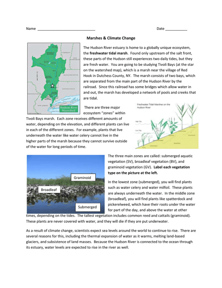
Name _____________________________ Date ___________ Marshes & Climate Change The Hudson River estuary is home to a globally unique ecosystem, the freshwater tidal marsh. Found only upstream of the salt front, these parts of the Hudson still experiences two daily tides, but they are fresh water. You are going to be studying Tivoli Bays (at the star on the watershed map), which is a marsh near the village of Red Hook in Dutchess County, NY. The marsh consists of two bays, which are separated from the main part of the Hudson River by the railroad. Since this railroad has some bridges which allow water in and out, the marsh has developed a network of pools and creeks that are tidal. There are three major ecosystem “zones” within Tivoli Bays marsh. Each zone receives different amounts of water, depending on the elevation, and different plants can live in each of the different zones. For example, plants that live underneath the water like water celery cannot live in the higher parts of the marsh because they cannot survive outside of the water for long periods of time. The three main zones are called: submerged aquatic vegetation (SV), broadleaf vegetation (BV), and graminoid vegetation (GV). Label each vegetation type on the picture at the left. Graminoid In the lowest zone (submerged), you will find plants such as water celery and water milfoil. These plants Broadleaf are always underneath the water. In the middle zone (broadleaf), you will find plants like spatterdock and pickerelweed, which have their roots under the water Submerged for part of the day, and above the water at other times, depending on the tides. The tallest vegetation includes common reed and cattails (graminoid). These plants are never covered with water, and they will die if they are put underwater. As a result of climate change, scientists expect sea levels around the world to continue to rise. There are several reasons for this, including the thermal expansion of water as it warms, melting land-based glaciers, and subsistence of land masses. Because the Hudson River is connected to the ocean through its estuary, water levels are expected to rise in the river as well. 1. Look at the graph at right. a. Describe the graph. The graph shows the increase of sea level (in m) at the Battery in NYC from 1850 through 2010. (The “0” refers to the mean sea level datum that is established by the Center for Operational Oceanographic Products & Services. Students will not know this, but it may help you explain to students why the trend started below “O” – the mean is calculated over the course of the entire sample, and then the data points are plotted in reference to that mean, to show how much change there has been over time instead of just showing the actual height of the water. This data set has a very high confidence interval because there are so many years of data.) b. Based on what you know about climate change, why do you think the sea level has been rising at New York City over the last 100 years? Students might say that the sea level has been increasing because of melting glaciers, thermal expansion of seawater, inaccurate measurement, or they may think that NYC is actually sinking and therefore it only looks like the water level is increasing. 2. Based on what you know about freshwater tidal wetlands and the Hudson River, complete the prediction & explanation columns of this chart. Question Over the next 70 years, will global sea levels Over the next 70 years, will water levels in the Hudson River In 70 years, what will happen to the plant community in Hudson River wetlands? Prediction Increase? Decrease? Increase? Decrease? Explanation Students should say that global sea levels will increase because of increasing temperatures, melting glaciers and thermal expansion. Students should say that water levels in the HR will increase because the river is connected to the ocean and thus will experience the same changes as a result. Students may think that the amount of submerged vegetation will increase because there will be higher water levels. Others may think that there will be less SAV because the higher, deeper water will have fewer shallow areas where the vegetation can survive. Students may think there will be more broadleaf vegetation as the water levels increase and more areas are flooded.

