N E W YO RK S T A TE SO CI A L S T U DIE S RE SO U R CE T O OL KI T
2nd Grade Geography, Humans, and Environment Inquiry
How Do We Shape Our
Environment?
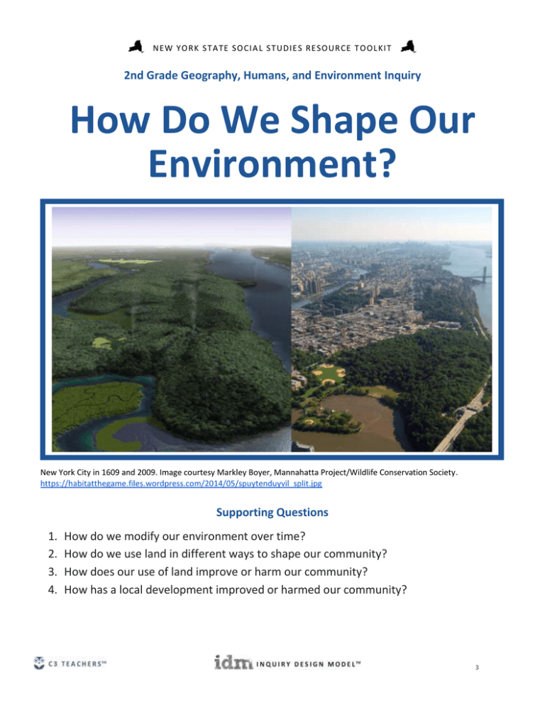
New York City in 1609 and 2009. Image courtesy Markley Boyer, Mannahatta Project/Wildlife Conservation Society.
https://habitatthegame.files.wordpress.com/2014/05/spuytenduyvil_split.jpg
Supporting Questions
1.
2.
3.
4.
How do we modify our environment over time?
How do we use land in different ways to shape our community?
How does our use of land improve or harm our community?
How has a local development improved or harmed our community?
[Cover Photo Needed]
3
N E W YO RK S T A TE SO CI A L S T U DIE S RE SO U R CE T O OL KI T
2nd Grade Geography, Humans, and Environment Inquiry
How Do We Shape Our Environment?
New York State
Social Studies
Framework Key Idea
& Practices
2.5: Geography and natural resources shape where and how urban, suburban, and rural communities
develop and how they sustain themselves.
Gathering, Using, and Interpreting Evidence
Staging the Question
Economics and Economic Systems
Watch a time-lapse video of a city being built and discuss what is changing and why.
Supporting Question 1
Supporting Question 2
Supporting Question 3
Supporting Question 4
Understand
Understand
Assess
Act
How do we modify our
environment over time?
Formative
Performance Task
Complete a graphic
organizer demonstrating
how people have modified
the environment of a
location in New York State.
Featured Sources
How do we use land in
different ways to shape our
community?
Formative
Performance Task
Create a community map
classifying land as
residential, industrial,
commercial, or
recreational.
Featured Sources
Source A: Image bank: New
York City in 1609 versus
2009
Source A: Image bank:
Various uses of land
Source B: Google Maps
How does our use of land
improve or harm our
community?
Formative
Performance Task
Formative
Performance Task
Complete a T-chart
demonstrating the pros and
cons of building the Tappan
Zee Bridge.
Create a group pictorial
essay demonstrating how a
local development has
helped or harmed the
community, and invite local
officials to class.
Featured Sources
Featured Sources
Source A: Image bank:
Historic and current images
of the Tappan Zee Bridge
Source A: Teacher- and
student-generated sources
on a local communitydevelopment project
Source B: Tappan Zee
Bridge: Life in Rockland
before the Span
Summative
Performance Task
Research Opportunity: How
has a local development
improved or harmed our
community?
ARGUMENT How do we shape our environment? Construct an argument supported by evidence that
addresses how we shape our environment and/or are shaped by our environment.
4
N E W YO RK S T A TE SO CI A L S T U DIE S RE SO U R CE T O OL KI T
Overview
Inquiry Description
This inquiry explores how communities develop and sustain themselves by examining the positive and negative
impacts of development on community environments. In considering the idea that communities grow and change
over time, students develop an argument with evidence that answers the compelling question “How do we shape
our environment?”
This inquiry embeds the Taking Informed Action sequence through the formative performance tasks. The
understand element is developed through Supporting Questions 1 and 2 while the assess element is represented in
Supporting Question 3. The act piece, the development of a pictorial collage that students then invite local officials
to view and discuss, is represented in Supporting Question 4.
In addition to the Key Idea expressed earlier, this inquiry reflects the following Conceptual Understandings:
(2.5b) The location of physical features and natural resources often affects where people settle and may
affect how those people sustain themselves.
(2.5c) Humans modify the environment of their communities through housing, transportation systems,
schools, marketplaces, and recreation areas.
NOTE: This inquiry is expected to take four to six 30-minute class periods. The inquiry time frame could expand if
teachers think their students need additional instructional experiences (i.e., supporting questions, formative
performance tasks, and featured sources). Teachers are encouraged to adapt the inquiries to meet the needs and
interests of their particular students. Resources can also be modified as necessary to meet individualized education
programs (IEPs) or Section 504 Plans for students with disabilities.
Structure of the Inquiry
In addressing the compelling question “How do we shape our environment?,” students work through a series of
supporting questions, formative performance tasks, and featured sources in order to construct an argument with
evidence and counterevidence from a variety of sources.
Staging the Inquiry
To launch this inquiry, students can view a time-lapse video
(https://www.youtube.com/watch?v=EBG5VGMoAlM) of the growth of a city and observe the changes that occur
(e.g., the building of new roads, houses, and commercial structures) while discussing the potential impact of these
changes.
5
N E W YO RK S T A TE SO CI A L S T U DIE S RE SO U R CE T O OL KI T
Supporting Question 1
The first supporting question—“How do we modify our environment over time?”—grounds the inquiry by
establishing the concept that humans modify and adapt their environments by building and developing housing
structures, transportation systems, marketplaces, and recreational areas. The featured source, a split image
depicting Manhattan before European settlement versus present day, is a visual representation of these kinds of
changes and provides an opportunity for students to imagine the kinds of environmental changes that
communities undergo. In the first formative performance task, students complete a graphic organizer documenting
the developments they observe in the community by comparing and contrasting the two images.
Supporting Question 2
The second supporting question—“How do we use land in different ways to shape our community?”—requires
students to examine how land is used in communities using the classifications of residential, commercial, industrial,
and recreational. The first featured source, an image bank depicting these classifications, helps students see
examples of each form of land use. The second featured source, Google Maps, allows students to zoom in on their
local communities. The formative performance task asks students to create community maps demonstrating and
classifying several parts of their communities.
Supporting Question 3
The third supporting question—“How does our use of land improve or harm our community?”—suggests that, as
humans modify their environments, these modifications can have positive and negative effects. The formative
performance task asks students to complete a T-chart documenting the pros and cons of a major human
modification—the construction of the Tappan Zee Bridge. The featured sources, an image bank of the bridge
construction and a video interview with a local resident, offer students ideas about how this specific development
and developments in general can have both positive and negative impacts on community environments.
Supporting Question 4
The final supporting question—“How has a local development improved or harmed our community?”—introduces
an opportunity to apply the ideas developed across the first three formative performance tasks to a research and
Taking Informed Action opportunity. In responding to the supporting question, students research a specific
development in their own communities and assemble ideas about its overall impact—positive, negative, or both.
Through independent and teacher-guided research, students use local newspapers, images, videos, and interviews
with community members as sources to complete the final formative performance task, the creation of a pictorial
essay to document how this development has impacted their community. This task also serves as an opportunity to
6
N E W YO RK S T A TE SO CI A L S T U DIE S RE SO U R CE T O OL KI T
Take Informed Action. Students may invite local elected officials to visit and view their projects and engage in a
conversation about the factors that should be weighed when undertaking such community developments. To
prepare for this conversation, students write interview questions about aspects of the development they
researched that they want to understand better and about community development in general.
Summative Performance Task
At this point in the inquiry students have examined how land is used and modified to form communities over time.
They have considered the reasons behind these modifications and developments and have questioned the
implications they have on community environments. Students should be able to demonstrate the breadth of their
understanding and their ability to use evidence from multiple sources to construct an evidence-based argument
responding to the compelling question “How do we shape our environment?”
Student arguments will likely vary, but could include any of the following:
We shape our environment by building highways, bridges, tunnels, apartments, factories, and stores, but
not always for the better.
We shape our environment for the better by creating bridges, highways, and big buildings.
We shape our environment by creating things that help people live better lives.
We sometimes shape the environment for the worse using farmland for buildings.
Students have the opportunity to Take Informed Action by developing a pictorial collage that students then invite
local officials to view and discuss. The understand element is developed through Supporting Questions 1 and 2
while the assess component is represented in Supporting Question 3. The act piece is represented in Supporting
Question 4.
7
N E W YO RK S T A TE SO CI A L S T U DIE S RE SO U R CE T O OL KI T
Staging the Compelling Question
Featured Source
Source A: SimCity, time-lapse video showing the growth of a city, See Our City Grow, March 12, 2013
NOTE: This video, from SimCity, offers a visual of how land can be transformed from grasslands and forests into a
modern city. Teachers and students can view the video at: https://www.youtube.com/watch?v=EBG5VGMoAlM
8
N E W YO RK S T A TE SO CI A L S T U DIE S RE SO U R CE T O OL KI T
Supporting Question 1
Featured Source
Source A: Image bank: New York City in 1609 versus 2009
NOTE: The two images below illustrate the change in the New York City landscape over time. The left-side image is an
recreation of what the right-side photograph likely looked like in 1609.
New York City in 1609 and 2009
Image courtesy Markley Boyer, Mannahatta Project/Wildlife Conservation Society.
https://habitatthegame.files.wordpress.com/2014/05/spuytenduyvil_split.jpg
9
N E W YO RK S T A TE SO CI A L S T U DIE S RE SO U R CE T O OL KI T
Supporting Question 2
Featured Source
Source A: Image bank: Various uses of land
Image 1: Residential use of land in a rural area.
iStock © cindygoff.
10
N E W YO RK S T A TE SO CI A L S T U DIE S RE SO U R CE T O OL KI T
Image 2: Residential use of land in an urban area.
© Jorge Salcedo/ Shutterstock.com.
11
N E W YO RK S T A TE SO CI A L S T U DIE S RE SO U R CE T O OL KI T
Image 3: Commercial use of land in a suburban area.
iStock © slobo.
12
N E W YO RK S T A TE SO CI A L S T U DIE S RE SO U R CE T O OL KI T
Image 4: Industrial use of land in an urban area.
iStock © akiyoko.
13
N E W YO RK S T A TE SO CI A L S T U DIE S RE SO U R CE T O OL KI T
Image 5: Recreational use of land in a suburban area
Shutterstock © kuponjabah.
14
N E W YO RK S T A TE SO CI A L S T U DIE S RE SO U R CE T O OL KI T
Supporting Question 2
Featured Source
Source B: Google Maps
NOTE: Google Maps is an extraordinary resource for looking at locations near and far. Access the site at
http://google.com/maps
Map data ©2015 Google.
15
N E W YO RK S T A TE SO CI A L S T U DIE S RE SO U R CE T O OL KI T
Supporting Question 3
Featured Source
Source A: Image bank: Historic and current images of the Tappan Zee Bridge
Image 1: Pilings for the bridge.
Courtesy Westchester County Historical Society.
16
N E W YO RK S T A TE SO CI A L S T U DIE S RE SO U R CE T O OL KI T
Image 2: Supporting piers for the bridge.
Courtesy Westchester County Historical Society.
17
N E W YO RK S T A TE SO CI A L S T U DIE S RE SO U R CE T O OL KI T
Image 3: Framework for the bridge.
Courtesy Westchester County Historical Society.
18
N E W YO RK S T A TE SO CI A L S T U DIE S RE SO U R CE T O OL KI T
Image 4: Completed bridge.
iStock © amlphoto.
19
N E W YO RK S T A TE SO CI A L S T U DIE S RE SO U R CE T O OL KI T
Supporting Question 3
Featured Source
Source B: Seth Harrison, website video interview with Winston Perry, Tappan Zee Bridge: Life in Rockland
before the Span, no date
NOTE: The screen shot below shows Winston Perry who narrates the history of the area around the Tappan Zee
bridge. The video begins with a commercial.
From The Journal News, © Gannett-CN. All rights reserved. Used by permission and protected by the Copyright Laws of the United
States. The printing, copying, redistribution, or retransmission of this content without express written permission is prohibited.
20
N E W YO RK S T A TE SO CI A L S T U DIE S RE SO U R CE T O OL KI T
Supporting Question 4
Featured Source
Source A: Teacher- and student-generated sources on a local community-development project
Teachers and their students generate sources around a community project (e.g., the development of a new park, a
new housing project, demolition of an old factory) of local origin.
21

