Pangaea Revisited student copy
advertisement
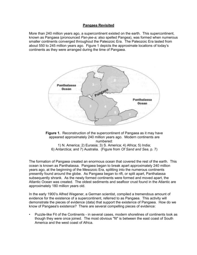
Pangaea Revisited More than 240 million years ago, a supercontinent existed on the earth. This supercontinent, known as Pangaea (pronounced Pan-jee-a; also spelled Pangea), was formed when numerous smaller continents converged throughout the Paleozoic Era. The Paleozoic Era lasted from about 550 to 245 million years ago. Figure 1 depicts the approximate locations of today’s continents as they were arranged during the time of Pangaea. Figure 1. Reconstruction of the supercontinent of Pangaea as it may have appeared approximately 240 million years ago. Modern continents are numbered: 1) N. America; 2) Eurasia; 3) S. America; 4) Africa; 5) India; 6) Antarctica; and 7) Australia. (Figure from Of Sand and Sea, p. 7) The formation of Pangaea created an enormous ocean that covered the rest of the earth. This ocean is known as Panthalassa. Pangaea began to break apart approximately 240 million years ago, at the beginning of the Mesozoic Era, splitting into the numerous continents presently found around the globe. As Pangaea began to rift, or split apart, Panthalassa subsequently shrank. As the newly formed continents were formed and moved apart, the Atlantic Ocean was created. The oldest sediments and seafloor crust found in the Atlantic are approximately 180 million years old. In the early 1900’s Alfred Wegener, a German scientist, compiled a tremendous amount of evidence for the existence of a supercontinent, referred to as Pangaea. This activity will demonstrate the pieces of evidence (data) that support the existence of Pangaea. How do we know of Pangaea's existence? There are several compelling pieces of evidence: • Puzzle-like Fit of the Continents - in several cases, modern shorelines of continents look as though they were once joined. The most obvious "fit" is between the east coast of South America and the west coast of Africa. • Fossil Evidence - fossils of a fresh water swimming reptile, Mesosaurus (Figure 2) have been found on the east coast of southern Brazil and the west coast of Africa. This reptile could not possibly have swum the 3,000-mile distance across the South Atlantic Ocean. There are many other examples of fossils currently found on two continents that are separated by vast oceans. In addition to fossils of animals, plant fossils and pollen have also been used to “connect” two distant continents. Figure 2. Freshwater reptile Mesosaurus. • Glacial Deposits - Paleozoic (i.e., >245 million years old) glacial deposits have been found in southernmost regions of South America, Africa and Australia. Glacial striations, the parallel "scrape" marks on rocks caused by moving glaciers, have been found on rocks in these regions and are of similar orientation to corresponding striations found on Antarctica, indicating that glaciers moved across the regions when the continents were attached as part of Pangaea. • Mountain Belts - some mountain belts, or mountain chains, have very similar rocks and structures (i.e., folds and faults) to mountain belts found on other continents. These paired mountain belts are older than 245 million years and were originally formed when Pangaea first assembled. When the continents collided in the late Paleozoic, enormous "wrinkles" of mountains were created. These mountain belts were originally elongate and parallel to the contact line of collision. Some of the mountain belts formed during the assembly of Pangaea are now quite eroded and are not as prominent today, such as the southern Appalachians in the southeastern United States. Although the activity only addresses the evidence for Pangaea’s existence, it is important to understand how Pangaea relates to the Continental Drift Hypothesis and why this hypothesis was not fully accepted. Continental Drift Hypothesis Even with the tremendous amount of evidence supporting Pangaea’s existence, the nagging questions remained: How and why did the modern continents form and move to their present locations? With Pangaea’s existence as its foundation, Wegener proposed the Continental Drift Hypothesis, which stated that Pangaea broke apart, or rifted, and the continents “drifted” to their modern locations. He hypothesized that the less-dense continental land masses "floated" on a more-dense molten rock foundation. Wegener believed that when Pangaea broke apart the continents plowed across the ocean floor on their journey, forming mountain chains at their leading edges as the rocks buckled. He also hypothesized that masses of ocean floor sediments were bulldozed in front of each continent. Unfortunately, no evidence of bulldozed sediments or buckled leading-edged continents existed. Wegener had no testable explanation or solid evidence for the fragmentation of Pangaea and the movement of continents across the globe. In other words, his hypothesis lacked an explanation for how and why continents would rift and drift. Only the existence of Pangaea was supported by scientific evidence. Therefore, the Continental Drift Hypothesis was not an acceptable hypothesis and it was never elevated to the status of being a theory. A common misconception is that “Continental Drift” is synonymous with “Plate Tectonics.” Actually, these two concepts are very different with respect to the proposed continental movement through time. Continental Drift is not an acceptable hypothesis because it did not include either a viable mechanism or sufficient evidence to explain how and why continents moved from their position within Pangaea to their present locations. However, the concept of a supercontinent, Pangaea, is still accepted because of the abundance of data supporting its existence. The development of the Plate Tectonics Theory built upon the evidence for Pangaea, while introducing additional evidence (e.g., seafloor spreading, subduction, hot spots) for how and why Pangaea broke apart and formed many plates that include today’s continents. Continents do not independently “drift” across the seafloor. Rather, continents are part of much larger crust and upper mantle lithospheric plates that move as a result of heat, gravity, and the creation and destruction of portions of each plate’s edges. There is a wealth of data that supports the Plate Tectonic Theory, and there is still much to discover in the pursuit of understanding the motion of our dynamic planet’s surface. Procedure In this activity, the major continents as we know them today are included on the attached worksheet pages. Greenland and India are also included as separate pieces. 1. Students should glue the pages with continents onto cardboard, and then cut out each continent or land mass to make the eight puzzle pieces. Tell the students to cut the general shape of the continents, not all of the finer details. Students must be reminded that the modern shape of the continents is probably not the exact shape they had 240 million years ago, so that the puzzle-like “fit” is far from perfect! 2. Once the puzzle pieces are ready, discuss the types of evidence described in the Background section, above. Note that there are several letters written on the edges of many of the pieces. The key to the letters is as follows: F = fossils M = mountain belts G = glacial deposits (Arrows show the orientation of glacial striations, described below) There are a few additional bits of information that should be told to the students, and possibly, should be written on the board or on an overhead transparency: a. Central American did not exist 240 million years ago, so that another puzzle piece can rest on top of it. Students may opt to fold Central America under, or cut it off. b. Remember that a perfect fit will not be achieved, but there is only one correct arrangement, based on the data presented. c. Students will use the “geologic evidence” shown by the letters, as well as the puzzle-like fit of the continents, to reconstruct or reassemble Pangaea. For each letter there is only one corresponding letter on another continent. For example, a continent with 3 “G’s” should fit another continent with 3 “G’s”. d. It’s much easier to place India into the puzzle last. (India was once attached to Africa and Antarctica. The teacher may want to assist for this part of the puzzle.) 3. Begin the reconstruction by having students find the North American continent (this is where geography comes in, as the names of the continents are intentionally not on the puzzle pieces). 4. Compare the completed puzzles with Worksheet #4. Once all the puzzles have been arranged correctly, compare them with Figure 1. Figure 1 illustrates what the ancient shorelines probably looked like. Have the students discuss differences between the “old” shoreline shapes and “today’s” shoreline shapes. Where is Panthalassa? Assessment 1. Explain how mountain chains provided evidence for the existence of Pangaea. 2. Explain how fossils provided evidence for the existence of Pangaea. 3. Explain why India has evidence of glaciers that are more than 240 million years old even though it is located on the equator. PUZZLE PIECES – WORKSHEETS 1-4

