PRT06_Salem_YenJ
advertisement

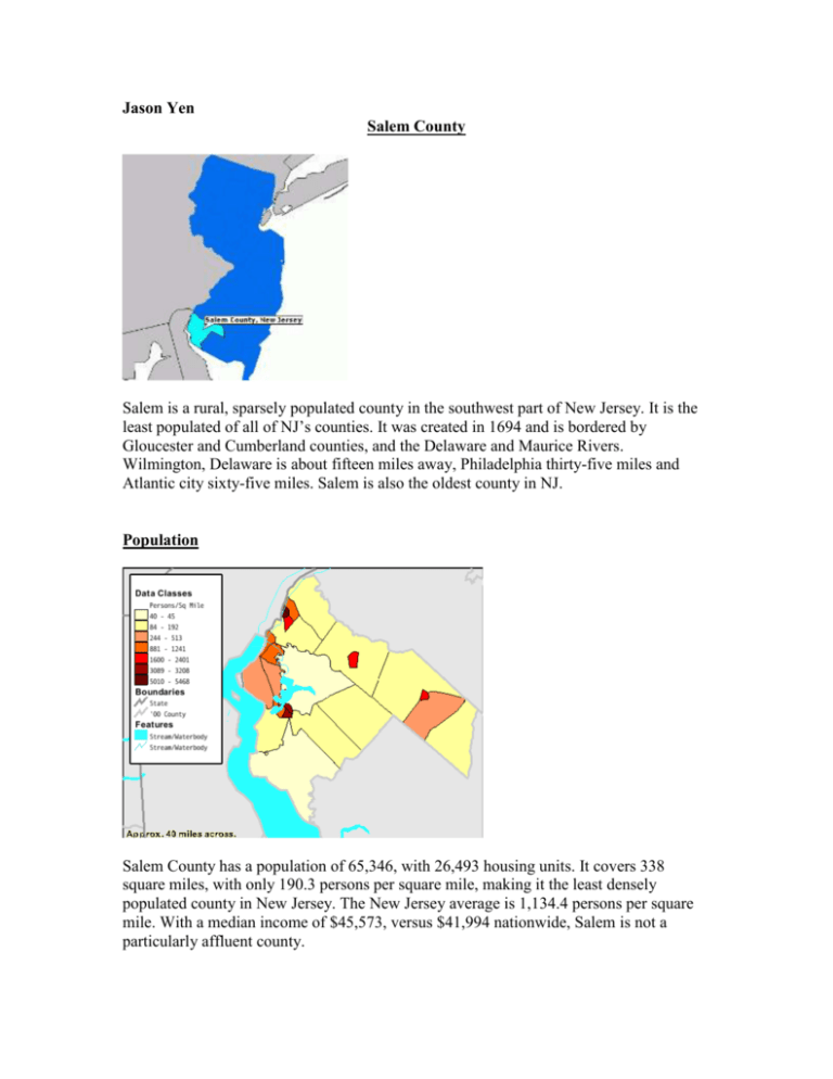
Jason Yen Salem County Salem is a rural, sparsely populated county in the southwest part of New Jersey. It is the least populated of all of NJ’s counties. It was created in 1694 and is bordered by Gloucester and Cumberland counties, and the Delaware and Maurice Rivers. Wilmington, Delaware is about fifteen miles away, Philadelphia thirty-five miles and Atlantic city sixty-five miles. Salem is also the oldest county in NJ. Population Salem County has a population of 65,346, with 26,493 housing units. It covers 338 square miles, with only 190.3 persons per square mile, making it the least densely populated county in New Jersey. The New Jersey average is 1,134.4 persons per square mile. With a median income of $45,573, versus $41,994 nationwide, Salem is not a particularly affluent county. Land Use As a result of its sparse population, Salem is a primarily rural county. Almost half Salem’s 338 square miles consists of farms. Much of Salem remains undeveloped, and according to the NJ Visitor’s Network, it boasts a over 34,000 acres of meadow and marshland, tidal and freshwater wetlands, and 40 lakes and ponds. Transportation According to Census data, only 1.2% of Salem residents take public transportation to work, versus 9.6% in NJ as a whole. Instead, it is highly dependent on local car travel, 93.3% of residents use a motor vehicle to get to work. Only two New Jersey Transit buses service the area (#423 & #468), and NJ Transit trains do not operate in Salem. These statistics are unsurprising given Salem’s rural nature. Since the population is so sparsely populated, more extensive public transportation would likely be costly and inefficient. Non farm workers generally commute to nearby Philadelphia or Wilmington, but this commute takes place primarily outside of the county The following is a map of the mean travel time, and the highways which service Salem. Developing the Personal Rapid Transit Editor To build a PRT system, I collaborated with a colleague, Steven An, a computer science major at Berkeley, to develop a PRT interface utilizing Google Maps. While viewing satellite images of a particular county via Google, the PRT editor allowed users to place stations and interchanges on the satellite maps, and then connect them using lines demarcating rail links. Each station and interchange was stored along with its coordinates, the upstream/downstream nodes and distances, and the user-inputted population, attraction data. In addition, the PRT Editor allowed students to edit their own individual counties, and then compiled all the county networks into one state-wide network. Salem PRT Network The Salem PRT Network consists of 176 stations, 87 interchanges, and 460 miles of track. The relatively few number of stations reflects the rural nature of Salem. Most stations are located along the western part of the county, which is more densely populated, and closer to the metropolitan areas of Pennsylvania. Assuming a cost of $1 million per station, and $1 and $3 million per mile of rural and urban guideway, for which 75% of the Salem network’s tracks are rural, the entire Salem PRT network is estimated to cost $866 million. This translates to a cost of $13,323 per resident. This large sum, relative to other counties, reflects the difficulty in designing a network for such a rural, vast, and sparsely populated county. To provide adequate accessibility requires a constructing great deal of guideway and low-density serving stations. Each guideway is one way, to minimize traffic and congestion. However, the network is still interconnected, such that every station is accessible to every other station. To design the network, Google Earth was used to locate points of interest and major populations and attractions. A PRT station was placed at least 3/8 of a mile near each major location, in order to provide maximum service. The U.S. Census estimates 28,748 commuting workers in Salem County, with 26,814 driving an automobile. It also estimates 16,618 students. If we assume that 75% of these convert to the PRT system, we can estimate a regular daily commuter ridership of about 34,000, with over half of the county’s population taking the PRT daily. Service to Schools Salem has 14 school districts, with 18 elementary schools, 5 middle schools, 6 high schools, and one college. Most elementary schools are generally within walking distance, the PRT will serve all middle schools, high schools and Salem Community College. Currently, there are 16,618 residents enrolled in school, with 12.3%, 73%, and 14.7% as kindergarten, grade school, and college students, respectively. School District Alloway Twp 1. ALLOWAY TWP SCHOOL Elmer Boro, 1. ELMER Elsinboro Twp 1. ELSINBORO TWP Lower Alloways Creek 1. LOWER ALLOWAYS CREEK Mannington Twp: 1. MANNINGTON Oldmans Twp 1. OLDMANS MIDDLE SCHOOL 2. PEDRICKTOWN Penns Grv-Carney's Pt Reg 1. FIELD ST 2. LAFAYETTE-PERSHING 3. PAUL W CARLETON 4. PENNS GROVE HIGH 5. PENNS GROVE MIDDLE SCHOOL Pennsville 1. CENTRAL PARK 2. PENN BEACH 3. PENNSVILLE MEMORIAL H 4. PENNSVILLE MIDDLE 5. VALLEY PARK Pittsgrove Twp 1. ARTHUR P SCHALICK H S 2. NORMA SCHOOL 3. OLIVET SCHOOL 4. PITTSGROVE TWP MIDDLE SCH Quinton Twp 1. QUINTON TWP Salem City 1. JOHN FENWICK 2. SALEM HIGH 3. SALEM MIDDLE Salem Co Special Service 1. DARETOWN SCHOOL Upper Pittsgrove Twp 1. UPPER PITTSGROVE Woodstown-Pilesgrove Reg 1. MARY S SHOEMAKER 2. WOODSTOWN HIGH 3. WOODSTOWN MIDDLE Private Schools 1. BETHANY CHRISTIAN ACADEMY 2. COHANSEY SCHOOL 3. PARK BIBLE ACADEMY 4. RANCH HOPE FOR BOYS, INC. Colleges Salem Community College Service to Employers The PRT network provides access to all of the following major employers of Salem County. Major Employers and # of employees PSEG 1,965 E.I. duPont 1,450 Mannington Mills 860 Memorial Hospital of Salem County 800 Conectiv 529 Anchor Glass 361 SJ Hospital Systems-Elmer 350 The GEON Company 200 B & B Poultry 168 Ganes Chemicals 155 Ranch Hope 145 Wire-Pro, Inc 130 SalemCare 130 Woodstown National Bank 130 Walt’s Bus Service 130 PSEG Nuclear Training 114 SJ Transportation Co 80 Cumberland Dairy 80 Unico Services 77 Spark’s Electric, Inc 75 First National Bank of Elmer 69 PG&E Generating 66 MAC Specialty Coatings 58 Franklin Savings Bank 55 Service to Residential Areas By using satellite imagery of Salem County, major residential areas were easily located, and PRT stations were placed to service Salem residents. Particularly in urban areas, PRT access will be plentiful, allowing individuals to get close to home without requiring an automobile. Service to Commercial Areas A huge benefit of the PRT will be to facilitate residents in the more rural middle and eastern sections of Salem to access the more urban, commercialized parts on the west, without requiring a car. Markets, restaurants, malls, now become more easily accessible, eliminating the need to drive cars, or wait for sparse public transportation. The following is a list of some, although not all, commercial attractions serviced by the new PRT network: Hotels Holiday Inn Express Libraries Elmer Public Library Penns Grove-Carney's Pt. Library Pennsville Public Library Salem Free Public Library Woodstown-Pilesgrove Library Bowling Alleys Penn Bowl Marinas Penn Salem Marina Salem Boat Exchange Golf Holly Hills Golf Club Town & Country Golf Links Parks Camp Crocket Country Park Fort Mott State Park New Jersey Coastal Heritage Trail Wood Lanes Bowling Center Designing the Network The network was developed by using the Google Earth interface, which displays points of interest along with the PRT editor. A hub-and-spoke mnodel was generally employed to service the more urban areas of Salem, while long, guideways, punctuated by occasional stops, were the norm for the greater rural areas. The vast distances between residential locations, and the large number of farms, marshlands, and lakes, made a hub-and-spoke model seem most adequate, since this allowed denser, independent, centralized network sections in the urban sections, while not overutilizing track in less populated areas. Guideways were generally placed along existing roads, when possible, in order to reduce the amount of property needed and the potential environmental damage, during network construction. The network shown above borders the Delaware River, and shows the Delaware Memorial Bridge. I have chosen this section to be a major developmental area of the Salem PRT network. Due to its proximity to an important thoroughfare for accessing Delaware and Philadelphia, this area could be developed into a vibrant river-side night life community, like the Bund of Shanghai, replete with bars, night clubs, discotheques, and restaurants. Rural residents from Salem and nearby parts of Delaware could easily access the area at night, without concern over driving dangers. Conclusion Given the small population and vast area covered by Salem, the PRT network may seem too expensive, at an initial $866 million cost, not including the subsequent yearly operating costs. However, the system must be viewed as integrated with an entire statewide network. By providing an intra-county PRT network, the system also allows residents to more easily commute outside of the county. Although traffic is not generally a problem in Salem, many county residents commute to other parts of NJ for work. Thus, traffic on other highways and roads outside of Salem could be reduced through providing a state-wide network. In addition, the PRT can help vitalize the still dormant urban areas in Salem by making them more accessible to the primarily rural residents.


