Hoyt & Harris-Ullman Urban Land Use Models
advertisement
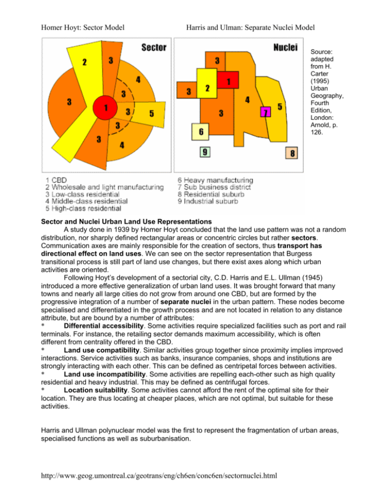
Homer Hoyt: Sector Model Harris and Ulman: Separate Nuclei Model Source: adapted from H. Carter (1995) Urban Geography, Fourth Edition, London: Arnold, p. 126. Sector and Nuclei Urban Land Use Representations A study done in 1939 by Homer Hoyt concluded that the land use pattern was not a random distribution, nor sharply defined rectangular areas or concentric circles but rather sectors. Communication axes are mainly responsible for the creation of sectors, thus transport has directional effect on land uses. We can see on the sector representation that Burgess transitional process is still part of land use changes, but there exist axes along which urban activities are oriented. Following Hoyt’s development of a sectorial city, C.D. Harris and E.L. Ullman (1945) introduced a more effective generalization of urban land uses. It was brought forward that many towns and nearly all large cities do not grow from around one CBD, but are formed by the progressive integration of a number of separate nuclei in the urban pattern. These nodes become specialised and differentiated in the growth process and are not located in relation to any distance attribute, but are bound by a number of attributes: * Differential accessibility. Some activities require specialized facilities such as port and rail terminals. For instance, the retailing sector demands maximum accessibility, which is often different from centrality offered in the CBD. * Land use compatibility. Similar activities group together since proximity implies improved interactions. Service activities such as banks, insurance companies, shops and institutions are strongly interacting with each other. This can be defined as centripetal forces between activities. * Land use incompatibility. Some activities are repelling each-other such as high quality residential and heavy industrial. This may be defined as centrifugal forces. * Location suitability. Some activities cannot afford the rent of the optimal site for their location. They are thus locating at cheaper places, which are not optimal, but suitable for these activities. Harris and Ullman polynuclear model was the first to represent the fragmentation of urban areas, specialised functions as well as suburbanisation. http://www.geog.umontreal.ca/geotrans/eng/ch6en/conc6en/sectornuclei.html
