Chapter 6, Parks, Recreation and Open Space
advertisement
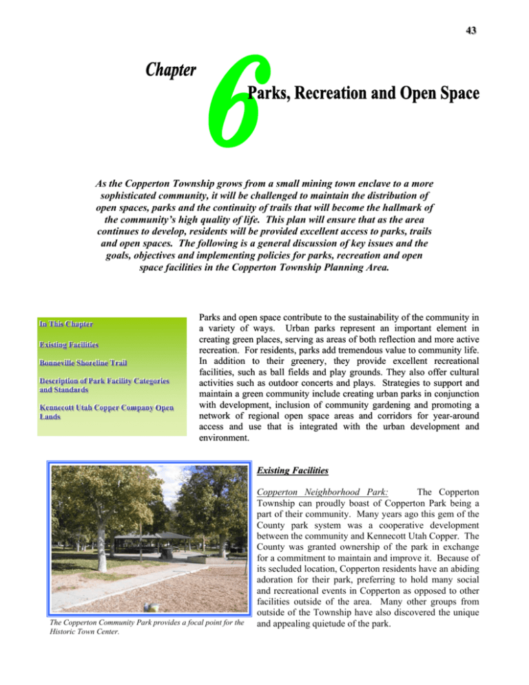
4433 As the Copperton Township grows from a small mining town enclave to a more sophisticated community, it will be challenged to maintain the distribution of open spaces, parks and the continuity of trails that will become the hallmark of the community’s high quality of life. This plan will ensure that as the area continues to develop, residents will be provided excellent access to parks, trails and open spaces. The following is a general discussion of key issues and the goals, objectives and implementing policies for parks, recreation and open space facilities in the Copperton Township Planning Area. IIInnnT C T Chhhaaapppttteeerrr ThhhiiisssC E E ExxxiiissstttiiinnngggFFFaaaccciiillliiitttiiieeesss B B T BooonnnnnneeevvviiilllllleeeSSShhhooorrreeellliiinnneeeT Trrraaaiiilll D D C Caaattteeegggooorrriiieeesss DeeessscccrrriiippptttiiiooonnnooofffPPPaaarrrkkkFFFaaaccciiillliiitttyyy C aaannndddSSStttaaannndddaaarrrdddsss K m C C U K O Opppeeennn Cooom CoooppppppeeerrrC mpppaaannnyyy O UtttaaahhhC KeeennnnnneeecccooottttttU L L Laaannndddsss Parks and open space contribute to the sustainability of the community in a variety of ways. Urban parks represent an important element in creating green places, serving as areas of both reflection and more active recreation. For residents, parks add tremendous value to community life. In addition to their greenery, they provide excellent recreational facilities, such as ball fields and play grounds. They also offer cultural activities such as outdoor concerts and plays. Strategies to support and maintain a green community include creating urban parks in conjunction with development, inclusion of community gardening and promoting a network of regional open space areas and corridors for year-around access and use that is integrated with the urban development and environment. Existing Facilities The Copperton Community Park provides a focal point for the Historic Town Center. Copperton Neighborhood Park: The Copperton Township can proudly boast of Copperton Park being a part of their community. Many years ago this gem of the County park system was a cooperative development between the community and Kennecott Utah Copper. The County was granted ownership of the park in exchange for a commitment to maintain and improve it. Because of its secluded location, Copperton residents have an abiding adoration for their park, preferring to hold many social and recreational events in Copperton as opposed to other facilities outside of the area. Many other groups from outside of the Township have also discovered the unique and appealing quietude of the park. 4444 Copperton Township The General Plan The 10-acre Park is located in the south-central part of the community. The park contains playground facilities, four tennis courts, horseshoe pits, basketball courts, a picnic pavilion and the open park area with picnic tables scattered throughout the facility. The park is well used by community residents and is sufficient to serve the present and long term needs of the historic town center. Additional Parks and Recreation Facilities: Other facilities that could easily be made available for recreation purposes are the baseball and football fields behind the Old Bingham High School. Recent changes to the old school site have improved the appearance from the road and include landscaping and the construction of a physical fitness trail “Par Course.” With maintenance these fields could provide use for soccer, football, baseball, softball and other organized sports activities. The Bingham Lions Club, located across Hillcrest Street from the park, serves as a meeting place for community groups and hosting many other public events. It also serves as a recreation center. In addition, there are several facilities in West Jordan and other communities in the west part of the valley. Bonneville Shoreline Trail The Bonneville Shoreline Trail is a unique opportunity to assist in providing access and connectivity to public and private lands. The B.S.T. is a proposed countywide regional trail that could run along the old Lake Bonneville shoreline in a north-south direction at about an elevation of Many of the local community functions and celebrations take place at the Bingham Lions Club located across from the approximately 5200 feet. At this elevation there is a park. distinct bench of the old shoreline, a level surface suitable for a trail. Several sections of the trail have already been constructed along the east bench in Salt Lake City and other sections in the Salt Lake Valley are being planned. Because the B.S.T. runs parallel to the foothills near the eastern edge of the Township, the trail crosses many of the access points and drainages that lead into the higher elevations of the Oquirrh Mountains. Description of Park Facility Categories and Standards Regional Parks: Large urban parks are recreational areas that may serve an entire region. These are often over 100 acres and may include areas of natural quality suitable for outdoor recreation activities such as golfing, picnicking, boating, fishing, swimming, camping and hiking. Large urban parks may be more specialized than the community or neighborhood parks. They sometimes contain traditional park facilities like playground structures or tennis courts, but they may also be dedicated to one particular use, such as golf. Large urban parks are usually located to take advantage of unique natural or cultural features. Community Parks: Community parks are planned primarily to provide active and structured recreation opportunities for young people and adults. In general, community park facilities are designed for organized activities and sports, although Parks, Recreation and Open Space Chapter 6 4455 individual and family activities are also encouraged. They usually exceed 15 acres and serve an area of one-to-two mile radius. These parks often have sport fields, water bodies, nature interpretive trails or similar features as the central focus of the park. The larger multi-service community parks are economically beneficial in that they provide a wider range of activities, are easier to program and are less expensive to maintain on a per acre basis. Neighborhood Parks: Neighborhood Parks are a combination playground and park designed primarily for non-supervised, non-organized recreation activities. In addition to their recreation value, they also provide a source of open space and aesthetic quality in the neighborhood. As these parks are Playground equipment and opportunities for other sport and located within walking and bicycling distance of recreation are common within community and neighborhood parks. most users, the activities they offer become daily pastimes for children. Neighborhood parks are generally small in size (5 to 15 acres) and serve an area of approximately a halfmile to a mile radius. The NRPA standards recommend 1.25 to 2.5 acres per 1,000 population. Users of a neighborhood park should not have to cross a major arterial street or other barriers, such as a river or steep slopes to reach a park. Mini Parks: Mini Parks are small single purpose play-lots designed primarily for use by young children. Because of their size, facilities are usually limited to a small grass area, a children’s playground and some seating areas. Mini parks are smaller (1 – 3 acres) and serve the area immediately surrounding the park (1/4 to 1/2 mile radius). No population ratio standard for this type of park is recommended. “Greenways” and Trail Corridors: Linear trails and greenways provide essential links between the parks and open spaces and should be designed for many modes of non-motorized recreational travel, i.e., walking, jogging, hiking, biking, horseback riding and cross-country skiing. The trails can be local connectors or part of a larger system that may have national or historical significance. The standard length, level of improvements and amenities is variable. Open Space: Open space is defined as predominately undeveloped land primarily left in its natural environment with recreation uses as a secondary objective. In some cases, environmentally sensitive areas are considered as open space and referred to as nature preserves. These areas can include wildlife habitats, wetlands, stream and creek corridors, or unique or endangered plant species. They provide relief from urbanization, better air quality, and habitat for flora and fauna. Community Gardens: Community gardening is not a new idea. It's been around for centuries. Probably, the Victory Gardens during and following World Wars 1 and 2 are the best-known Community Garden efforts. Community Gardens have many definitions, but basically, it's a garden available to the community members, with food or flowers grown by the members of the community. As opposed to backyard gardening, done by one or two gardeners, to benefit a few. 4466 Copperton Township The General Plan There are an estimated 10,000 community gardens within U.S. cities. These urban gardens provide a focal point for people to come together in the community and build neighborhood relationships. Community gardens get people talking to one another and can be used for therapeutic benefit and break the isolation for both the elderly and youth, creating a sense of neighborliness among residents. Additionally, community gardens provide an alternative for people in communities to simultaneously improve food security and their participation in a local food system. Kennecott Utah Copper Company Open Lands Undeveloped land is essential to maintaining the unique character and setting for the Copperton Township. Kennecott Utah Copper exclusively owns these undeveloped lands. Part of this undeveloped land could be developed. The maintenance of the areas’ character will depend on having key open spaces between developments. Key open spaces can be preserved through compliance with the Salt Lake County Foothills and Canyons Overlay Zone, as well as the Foothills and Canyons Site Development and Design Standards. Throughout this section and the entire Plan, the terms open space and open lands are used in different ways. Open space is land owned and managed by a public or quasi-public agency, such as the Salt Lake County Parks and Recreation Division, the U.S. Forest Service, Salt Lake City, or public utility. Public open space lands generally have a more liberal public access policy, and offer a wide range of recreational opportunities. In contrast, individuals, organizations or corporations such as Kennecott Utah Copper may hold open lands privately. Public access Although extensive mining operations exist along the Oquirrh Mountains, there is several thousand acres that remain as open lands. to private open space is usually restricted. Securing the land necessary to keep the "open feeling" characteristic of the Copperton Township will require increased coordination among property owners and private citizens. Some specific benefits other than enhancing the quality of life, include: Keeping a significant amount of natural open space Protecting important wildlife habitats, and movement corridors Dispersing recreational opportunities throughout the area Connecting the parks and recreational areas with planned linear pathways and open space corridors Protecting view corridors and visual amenities Reducing the threat of danger to life and property by avoiding development in natural hazard areas Minimizing the risk of source pollution by avoiding infringement in tributary areas. Parks, Recreation and Open Space Chapter 6 4477 Parks, Recreation, and Open Space Goals, Objectives and Policies GOAL OBJECTIVE IMPLEMENTING POLICIES Provide parks, open space, trails systems and recreational facilities for Copperton Township residents; offer safe and efficient recreation programs and activities that meet needs and desires. Objective 1 Provide a park system made up of a hierarchy of park types, each offering a certain type of recreation and (or) open space opportunity to ensure that every neighborhood and the entire Township is served by a comprehensive park system. 1. Develop parks in accordance to the design standards and policies identified in the Salt Lake County Parks and Recreation Master Plan. 2. Ensure that each neighborhood is provided with parks, open spaces and trails meeting the following basic requirements: Neighborhood Park of 7 to 10 acres in size serving residents within a radius of ½ mile. Community Park of at least 25 acres in size serving residents within a radius of 2 miles. Recreation amenities needed to support neighborhood demand. Trails system connecting internal open spaces, destination points and external trails. 3. Establish public and private partnerships to provide the necessary parks and recreation investments anticipated as development proposals on the vast Kennecott Utah Copper properties are solidified. 4. Periodically review demographic projections and land use plans in order to anticipate future recreation and facilities and program service needs and strive to meet or exceed the recreational standards established in the Parks and Recreation Master Plan. 5. Provide the necessary funding for acquisition and construction of new parks, trailheads, recreation facilities, and open space through general tax, bonds, federal, state, and county funding sources, and other means, consistent with the County’s budget needs. 6. Encourage community, public and private organizations to support the development, maintenance, and operation of existing and future recreational facilities. 7. Place a priority on locating neighborhood parks in conjunction with school sites and civic facilities. 8. Promote the development of community gardens in locations that can benefit residents, are conducive to agriculture, and will maintain compatibility with surrounding uses. 1. Develop multiple-use trails in accordance to the standards and policies identified in the Salt Lake County Parks and Recreation Master Plan. 2. Pursue the development of a “Rails to Trails” program in order to provide multiple-use trails along abandoned or vacated rail corridors. 3. Provide neighborhood trail and bicycle connections to transit stops, arterial streets, commercial areas, schools, civic centers, and other user-specific destinations. 4. Work to provide multi-functional “grade-separated crossings” such as bridges, roadway underpasses and other means at selected locations for pedestrians and bicyclists. 5. Work with the surrounding communities of the region to ensure pedestrian trail and bicycle route connectivity across jurisdictional lines. 6. Accommodate the needs of equestrian enthusiasts by providing a trail system and connections to the foothill and mountain areas. Pedestrian or multi-use trails are an excellent way to connect neighborhoods to civic uses and activity centers. Objective 2 Provide convenient, connected multi-purpose trails, paths and bicycle routes that create linkages to other areas and facilities, and provide non-vehicular options for travel throughout the community. (continued on the next page) 4488 Copperton Township The General Plan Objective 3 Design and operate safe parks, open space, trails and recreation facilities. Objective 4 Open the Oquirrh Mountains and foothill areas to provide natural open space areas where the public can access and observe nature and obtain a high level of solitude not provided by typical parks. 1. Ensure that open spaces have visibility from adjoining properties and streets, thereby helping to keep such spaces safe. 2. Promote the use of Crime Prevention through Environmental Design (CPTED) techniques when designing and building parks and trails. 3. Design and install appropriate lighting in all Township parks. 4. Form volunteer citizen patrols to help keep parks safe and secure. 1. Develop a network of environmentally sensitive common open spaces and continuous recreational trail systems for public use within the Oquirrh Mountains and foothills. 2. Provide a buffer to protect wildlife habitat, watershed and other natural resources, and also accommodate recreation options where appropriate as new foothills development occurs that adjoin public or private preserved lands. 3. Location and design of public access point to mountain and foothill areas that are easily accessible and minimize impacts or harm to wildlife.
