Tsunamis Lab: Earthquake & Wave Prediction Worksheet
advertisement
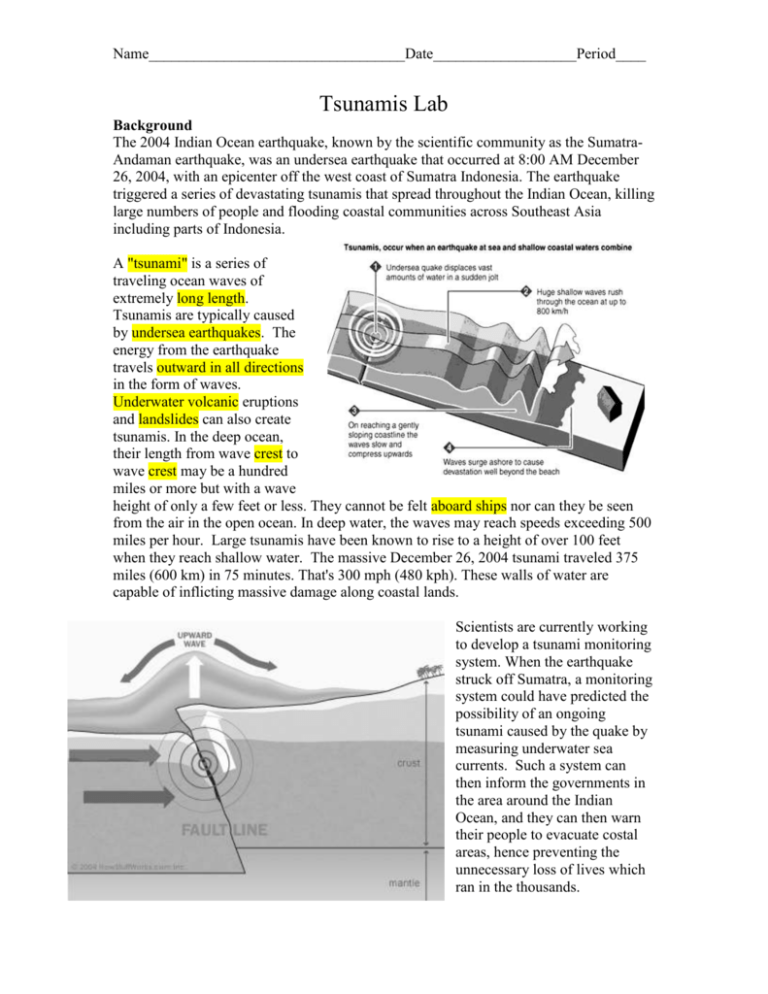
Name__________________________________Date___________________Period____ Tsunamis Lab Background The 2004 Indian Ocean earthquake, known by the scientific community as the SumatraAndaman earthquake, was an undersea earthquake that occurred at 8:00 AM December 26, 2004, with an epicenter off the west coast of Sumatra Indonesia. The earthquake triggered a series of devastating tsunamis that spread throughout the Indian Ocean, killing large numbers of people and flooding coastal communities across Southeast Asia including parts of Indonesia. A "tsunami" is a series of traveling ocean waves of extremely long length. Tsunamis are typically caused by undersea earthquakes. The energy from the earthquake travels outward in all directions in the form of waves. Underwater volcanic eruptions and landslides can also create tsunamis. In the deep ocean, their length from wave crest to wave crest may be a hundred miles or more but with a wave height of only a few feet or less. They cannot be felt aboard ships nor can they be seen from the air in the open ocean. In deep water, the waves may reach speeds exceeding 500 miles per hour. Large tsunamis have been known to rise to a height of over 100 feet when they reach shallow water. The massive December 26, 2004 tsunami traveled 375 miles (600 km) in 75 minutes. That's 300 mph (480 kph). These walls of water are capable of inflicting massive damage along coastal lands. Scientists are currently working to develop a tsunami monitoring system. When the earthquake struck off Sumatra, a monitoring system could have predicted the possibility of an ongoing tsunami caused by the quake by measuring underwater sea currents. Such a system can then inform the governments in the area around the Indian Ocean, and they can then warn their people to evacuate costal areas, hence preventing the unnecessary loss of lives which ran in the thousands. Name__________________________________Date___________________Period____ Tsunamis Lab Background The 2004 Indian Ocean earthquake, known by the scientific community as the SumatraAndaman earthquake, was an undersea earthquake that occurred at 8:00 AM December 26, 2004, with an epicenter off the west coast of Sumatra Indonesia. The earthquake triggered a series of devastating tsunamis that spread throughout the Indian Ocean, killing large numbers of people and flooding coastal communities across Southeast Asia including parts of Indonesia. A ___________ is a series of traveling ocean waves of extremely ________ _______. Tsunamis are typically caused by ____________ _______________. The energy from the earthquake travels ___________________ in the form of waves. _____________ ___________ eruptions and ___________ can also create tsunamis. In the deep ocean, their length from wave __________to wave _________may be a hundred miles or more but with a wave height of only a few feet or less. They cannot be felt ________________ nor can they be seen from the air in the open ocean. In deep water, the waves may reach speeds exceeding 500 miles per hour. Large tsunamis have been known to rise to a height of over 100 feet when they reach shallow water. The massive December 26, 2004 tsunami traveled 375 miles (600 km) in 75 minutes. That's 300 mph (480 kph). These walls of water are capable of inflicting massive damage along coastal lands. Scientists are currently working to develop a tsunami monitoring system. When the earthquake struck off Sumatra, a monitoring system could have predicted the possibility of an ongoing tsunami caused by the quake by measuring underwater sea currents. Such a system can then inform the governments in the area around the Indian Ocean, and they can then warn their people to evacuate costal areas, hence preventing the unnecessary loss of lives which ran in the thousands. Name__________________________________Date___________________Period____ Equipment: ruler, pencil, compass Purpose: To predict the time the tsunami created by the Sumatra-Andaman earthquake hit different locations. Procedure: 1. Find the “X” on the map this marks the epicenter of the earthquake 2. First mark distance of 1 cm intervals from the “X” on the map. One cm equals the distance the waves travel in 30 min. 3. Using the compass make circles over the areas covered by water. 4. Use the lines to estimate the time the tsunami hit each location 5. Fill in the data table with the number of lines and approximate arrival time of the tsunami. 6. Answer the questions Anatomy of a wave Name__________________________________Date___________________Period____ Tsunamis Lab - Answer Sheet Tsunami Data Table Location A B C D E Number of Lines Approximate Arrival Time Location Number of Lines F G H I J Sumatra-Andaman Tsunami Map Approximate Arrival Time Name__________________________________Date___________________Period____ Questions: 1. At what location and at what time did the tsunamis hit first? 2. At what location and at what time did the tsunamis hit last? 3. What location did the tsunamis never hit? Why? 4. What would be the distance to the first location hit if the waves travel at a speed of 300 mph? 5. What would be the distance to the last location hit? 6. In what direction do tsunami waves travel? 7. What was the energy source for this tsunami? 8. What was the medium for the Sumatra-Andaman Tsunami? 9. What type of wave is a tsunami? 10. The waves of a tsunami represent what moving through a medium?

