DECEMBER 2008 - HIKING & OUTING CLUB CALENDAR www
advertisement
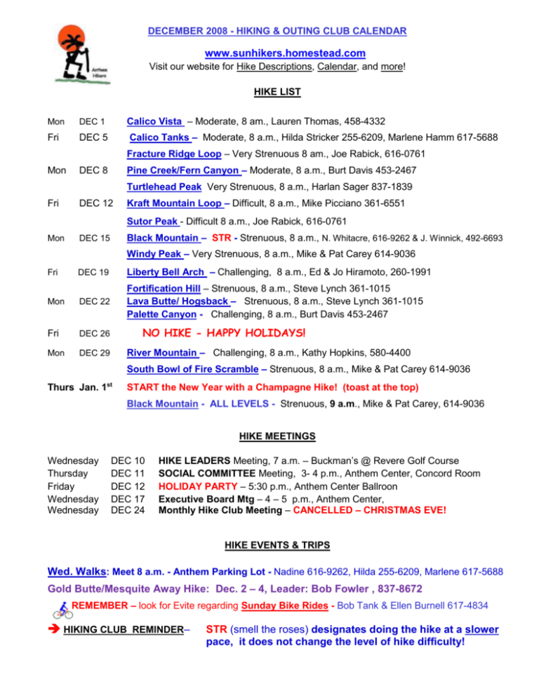
DECEMBER 2008 - HIKING & OUTING CLUB CALENDAR www.sunhikers.homestead.com Visit our website for Hike Descriptions, Calendar, and more! HIKE LIST Mon DEC 1 Fri DEC 5 Calico Vista – Moderate, 8 am., Lauren Thomas, 458-4332 Calico Tanks – Moderate, 8 a.m., Hilda Stricker 255-6209, Marlene Hamm 617-5688 Fracture Ridge Loop – Very Strenuous 8 am., Joe Rabick, 616-0761 Mon Pine Creek/Fern Canyon – Moderate, 8 a.m., Burt Davis 453-2467 DEC 8 Turtlehead Peak Very Strenuous, 8 a.m., Harlan Sager 837-1839 Fri DEC 12 Kraft Mountain Loop – Difficult, 8 a.m., Mike Picciano 361-6551 Sutor Peak - Difficult 8 a.m., Joe Rabick, 616-0761 Mon Black Mountain – STR - Strenuous, 8 a.m., N. Whitacre, 616-9262 & J. Winnick, 492-6693 DEC 15 Windy Peak – Very Strenuous, 8 a.m., Mike & Pat Carey 614-9036 DEC 19 Liberty Bell Arch – Challenging, 8 a.m., Ed & Jo Hiramoto, 260-1991 Mon DEC 22 Fortification Hill – Strenuous, 8 a.m., Steve Lynch 361-1015 Lava Butte/ Hogsback – Strenuous, 8 a.m., Steve Lynch 361-1015 Palette Canyon - Challenging, 8 a.m., Burt Davis 453-2467 Fri DEC 26 Mon DEC 29 Fri NO HIKE - HAPPY HOLIDAYS! River Mountain – Challenging, 8 a.m., Kathy Hopkins, 580-4400 South Bowl of Fire Scramble – Strenuous, 8 a.m., Mike & Pat Carey 614-9036 Thurs Jan. 1st START the New Year with a Champagne Hike! (toast at the top) Black Mountain - ALL LEVELS - Strenuous, 9 a.m., Mike & Pat Carey, 614-9036 HIKE MEETINGS Wednesday Thursday Friday Wednesday Wednesday DEC 10 DEC 11 DEC 12 DEC 17 DEC 24 HIKE LEADERS Meeting, 7 a.m. – Buckman’s @ Revere Golf Course SOCIAL COMMITTEE Meeting, 3- 4 p.m., Anthem Center, Concord Room HOLIDAY PARTY – 5:30 p.m., Anthem Center Ballroon Executive Board Mtg – 4 – 5 p.m., Anthem Center, Monthly Hike Club Meeting – CANCELLED – CHRISTMAS EVE! HIKE EVENTS & TRIPS Wed. Walks: Meet 8 a.m. - Anthem Parking Lot - Nadine 616-9262, Hilda 255-6209, Marlene 617-5688 Gold Butte/Mesquite Away Hike: Dec. 2 – 4, Leader: Bob Fowler , 837-8672 REMEMBER – look for Evite regarding Sunday Bike Rides - Bob Tank & Ellen Burnell 617-4834 HIKING CLUB REMINDER– STR (smell the roses) designates doing the hike at a slower pace, it does not change the level of hike difficulty! DECEMBER 2008 - HIKING & OUTING CLUB CALENDAR www.sunhikers.homestead.com Visit our website for Hike Descriptions, Calendar, and more! Hike Descriptions 4 miles. 750' elevation gain. Hike alongside Calico Hills with views of the Red Rocks and rock climbers. Easy scrambling with ups and downs on the red sandstone. Hike 2 miles to Sandstone Quarry and return on same route. Moderate. Calico Vista (RRC) 3 miles. 500' elev. gain. The route travels through a wash into a dry creek bed, then up the sandstone to the tanks and to a flat, white sandstone overlook with amazing views of Red Rock Park and Las Vegas Valley. A good introduction to rock scrambling. Strenuous - NP. 8 miles. 2,200' elev. gain. Adjacent to Black Mountain, this hike is more strenuous but has many of the same features...some exposure, scrambling, loose rock, and fantastic 360 degree views. Some of the verticals are steep climbs with lots of black volcanic rock. Bring gloves. Moderate. Calico Tanks (RRC) Fracture Ridge Loop #1 (Southeast of SCA) 4 miles. 200' elevation gain. Hike down Pine Creek Trail passing the cement foundation to the old Wilson homestead and into the wash. A good introduction to scrambling. Moderate. Pine Creek/Fern Canyon (RRC) 5 miles. 2,000' elevation gain to the 6,323' peak. Short but strenuous climb with scrambling, exposure and loose rock on parts of trail. Great unobstructed view of Las Vegas Valley. Experienced hikers only. Must call hike leader first. Difficult. NP. 4 miles. 600' net gain. Hike begins at 3,700 feet on nice trail ascending apx. 600 feet, then drops into a very scenic wash surrounded by colorful red and white sandstone cliffs. Boulder hopping required in the wash; some exposure. (More experienced hikers can climb down a waterfall, having 15 ft. exposure.) Very Strenuous. NP. Turtlehead Peak (RRC) Kraft Mountain Loop (Calico Basin Area in RR National Conservation Area) Sutor Peak (South of SCA) 9 miles. 1,200' elevation gain to a peak of 4,186' in the North McCullough Range. Scrambling, some exposure, loose lava rock. Difficult. NP. 4.5 miles. 2,500' elevation gain to a peak of 5,092'. Some exposure, scrambling, loose rock and brush. Hand holds needed for balance at times. Excellent 360-degree view of Las Vegas Valley, numerous ranges and the Eldorado Valley dry lake. Strenuous. NP. Black Mountain (Southeast of SCA) Windy Peak (South RR) Liberty Bell Arch (LM & Colo. River) 6 miles. 2,000' climb and scramble to a peak of 6,200'. Experienced hikers only. Must call hike leader first. High-clearance vehicles. Very Strenuous. NP. 4.5 miles. 1,000' gross elev. gain. No shade! 2 qts. water per person minimum. Views of Liberty Bell Arch, an old mine and the Colorado River. Challenging. 6 miles. 1,200' elev. gain. Some scrambling & exposure. A one-mile lava mesa on top of Fortification Hill overlooking Lake Mead on the east side of Hoover Dam. Fantastic views. Strenuous. NP. Fortification Hill (LM) Lava Butte (LM near Lake Las Vegas) Very Strenuous. NP. Palette Canyon Vegas) Challenging. (Lake Las 5 miles. 2,000' elevation gain. Scrambling with exposure. Steep, with crumbling rock. Experienced hikers only. Must call hike leader first. 4 miles. 400' elev. gain. Light scrambling. Follow an abandoned road north across the desert, then off-trail before dropping into a very colorful wash. 5.5 miles. 1,200' elevation gain. River Mtn. Trail heads north, then intersects with the Red and Black Mountain trails. Breathtaking views of Las Vegas, Lake Mead, Boulder City and Eldorado Valley. (Transition hike to qualify for more difficult hikes.) Challenging. River Mountain (Boulder City) DECEMBER 2008 - HIKING & OUTING CLUB CALENDAR www.sunhikers.homestead.com Visit our website for Hike Descriptions, Calendar, and more! South Bowl of Fire Scramble (LM) Strenuous. NP. 4.5 miles. 2,500' elevation gain to a peak of 5,092'. Some exposure, scrambling, loose rock and brush. Hand holds needed for balance at times. Excellent 360-degree view of Las Vegas Valley, numerous ranges and the Eldorado Valley dry lake. Strenuous. NP. Black Mountain (Southeast of SCA) 5 miles. 600' elevation gain. Lots of scrambling with exposure.
