Planetary Close-ups
emily lakdawalla
Spacecraft Imaging
for Amateurs
An international community of space
This is Mars’s Big Sky Country, a windswept, nearly
featureless plain. Tiny ripples in the rust-colored sand
march farther than the eye can see, to a horizon so flat
one might be able to see the curvature of the planet. As
far as anyone knows, those ripples have not budged in
eons. But all is not still; gaze upward, and you might be
surprised by the rapid motion overhead, where feathery
cirrus clouds, frosty with bright crystals of water ice, float
on high Martian winds.
The scene is from Meridiani Planum, composed from
eight images captured by the Mars Exploration Rover
Opportunity just before she reached a deep crater named
Victoria, on the 950th Martian day of her mission. But the
beautiful image was not created by anyone on the Mars
DATA: NASA / JPL
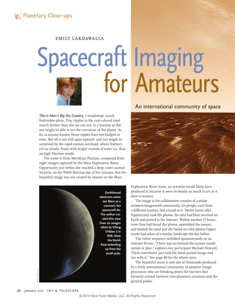
Earthbound
observers never
see Mars as a
crescent, but
spacecraft do.
The author created this view
from six images
taken by Viking
Orbiter 2 in
1976. Note
the bluish
frost extending
up from the
south pole.
76
January 2010
Exploration Rover team; no scientist would likely have
produced it, because it owes its beauty as much to art as it
does to science.
The image is the collaborative creation of a whole
amateur-imagesmith community; six people, each from
a different country, had a hand in it. Twelve hours after
Opportunity took the photos, the data had been received on
Earth and posted to the internet. Within another 17 hours,
rover fans had found the photos, assembled the mosaic,
and shaded the sand and sky based on color photos Opportunity had taken of a similar landscape the day before.
The entire sequence unfolded spontaneously on an
internet forum. “There was no behind-the-scenes coordination or plan,” explains key participant Michael Howard.
“Each contributor just took the latest posted image and
ran with it.” See page 80 for the whole story.
The beautiful scene is just one of thousands produced
by a lively international community of amateur image
processors who are breaking down the barriers that
formerly existed between interplanetary missions and the
general public.
sky & telescope
© 2010 New Track Media, LLC. All Rights Reserved
enthusiasts has become adept at reinterpreting images from planetary spacecraft.
DATA: NASA / JPL / CORNELL UNIVERSITY; PROCESSING: MICHAEL HOWARD / GLEN NAGLE
Buried Treasures
The vast majority of image data that has been sent to
Earth from the dozens of interplanetary missions never
sees official public release. For example, only a few hundred Voyager images have ever been prepared for publication, yet the two spacecraft returned more than 80,000
separate image products to Earth.
What happened to the rest of the data? It’s always
been available, just inconvenient for the general public
to access. Since 1966, when the National Space Science
Data Center (NSSDC) was established at NASA’s Goddard
Space Flight Center, the archived data from all science
missions has been made available to researchers upon
request and for a nominal fee. All NASA missions are
required to archive their data with the NSSDC after a
proprietary period has elapsed. Similar archives exist for
the Japanese and European space agencies.
In 1977 NASA established a system of Regional Planetary Imaging Facilities (RPIFs). RPIFs are like NASA
public libraries, storing collections of image data in both
digital and print formats. I whetted my own appetite for
space imaging at the Brown University RPIF, which hosts,
among other goodies, the entire Magellan Radar and
Lunar Orbiter image data sets in hard copy — thousands
of stunning photographic prints up to 30 by 40 inches
in size. I routinely dig into the archives for previously
unpublished views of the planets, like the unusual crescent
Hyperlinks for all the websites mentioned in
view of Mars shown at left.
this article can be found at SkyandTelescope
These resources were mostly
.com/amateur-spaceimaging.
only used by professional
researchers until recently. As
early as the 1980s, the NSSDC was distributing some
data electronically, but few in the wider public had the
bandwidth, hardware, or training necessary to download,
process, or understand the data.
That’s all changing. High-speed internet connections
and blazingly fast home computers have brought the
necessary bandwidth and hardware into people’s homes.
At the same time, the digital-photography revolution has
given millions of people basic image-processing skills.
In the past five years, several missions have given the
Sk yandTelescope.com
© 2010 New Track Media, LLC. All Rights Reserved
January 2010
77
Planetary Close-ups
public free access to raw image data almost as soon as it’s
received on Earth. As a result, amateurs can now download terabytes of data from dozens of planetary missions,
some of it only hours old.
Of course, the most exciting images from any mission
have most likely already been turned into products for
public release. So what’s in there to reward the amateur
who digs into the planetary image archives?
Quite a lot, actually. For instance, until recently,
nobody had seen an image of one of Neptune’s moons
passing in front of the planet. But last August, Ted Stryk
(a professional philosopher and amateur planetary scientist) realized that such images probably lay hidden in
the Voyager 2 archive. After much effort, he succeeded in
locating the relevant images and producing the amazing composite view shown on the facing page of Despina
and its shadow crossing Neptune’s face. “Processing the
Voyager images to get every last bit out of them is our
only way to get better close-ups of these worlds in the near
term,” remarks Stryk. “The only serious proposal for a
DATA: NASA / JPL; PROCESSING: MATTIAS MALMER
This view of Venus was composed from 78 frames taken by Mariner 10 in 1974. The colors were synthesized from images taken with orange and
ultraviolet filters. The clouds are more prominent than they would appear to the eye, but nowhere near as exaggerated as in pure UV images.
78
January 2010 sky & telescope
© 2010 New Track Media, LLC. All Rights Reserved
Sharing the Wealth
Space image data archives may be free, but they’re difficult for neophytes to access. Images are stored in a
peculiar format, and it takes considerable time and study
to learn how to find and process them. However, since
2004 there has been an explosion in public participation
DATA: NASA / JPL
return to Neptune is a mission called Argo. But assuming
it is approved (and that’s very questionable), it won’t get
there until 2029.”
I first encountered the amateur image-processing
community after being frustrated in an online search for
a photo of Venus as it might look to a human observer
flying in space. This request is easy to satisfy for all of the
other planets in the solar system, but the only spacecraft
images of Venus that I could find either showed it as seen
in ultraviolet light (which artificially exaggerates its cloud
patterns) or stripped of its atmosphere entirely (in global
views from the Magellan Radar Mapper).
During my searches I had stumbled across an online
forum called unmannedspaceflight.com, which had
started as a place for amateurs to share their work with
raw Mars Exploration Rover images, but which had broadened to cover work with all robotic spacecraft data sets.
After posting my request I was rewarded with new
views of Venus from Mariner 10, Venus Express, and Messenger. Why hadn’t any of the missions produced such
images for public release?
It’s because cameras are sent to space to gather data for
scientists, who have quite different goals from the general
public. When scientists are in charge of image processing,
they usually seek to emphasize faint features and subtle
differences in color, while taking care not to compromise
the quality of the images as science data. Fundamentally,
a science image is a matrix of data, encoding how many
photons of specific wavelengths of light are received at
a detector from a given location in space. To process an
image is to manipulate these matrices, performing calculations on the numbers. Excessive manipulation is not
only unnecessary, it departs from the actual data gathered
by the spacecraft.
The rest of us aren’t so tied to data fidelity; we want
pretty pictures that illustrate the adventure of space
exploration and allow us to imagine ourselves out there in
the solar system exploring these strange new worlds. So
when non-scientists get their hands on image data, they
process it in ways that scientists won’t: they paint out data
gaps, fiddle with contrast, sharpen photos by stacking or
filtering them, and produce color as the human eye might
see it by washing black-and-white images with color or by
computing red, green, and blue channels from data taken
in other wavelengths. The beautiful images that result are
rarely useable for research, but are uniquely appropriate
for illustration.
Twenty-year-old images discovered recently in the Voyager 2
archive by Ted Stryk (professor of philosophy at Roane State Community College) show tiny Despina and its shadow crossing the
face of Neptune.
in image processing thanks to the generosity of two scientists from the Mars Exploration Rover mission.
As NASA/Caltech’s Jet Propulsion Laboratory (JPL)
prepared for the launch and landing of the rovers, project
scientist Steve Squyres and imaging-team leader Jim Bell,
both of Cornell University, approached JPL with a new
idea: to allow the general public to experience the rover
missions as they unfolded by spewing all of the rovers’
image data directly to the internet.
The proposal was revolutionary; scientists have traditionally held their data close to the vest for as long as
possible. But, Bell says, “I truly believe that it’s a privilege
to be involved in exploring Mars. The folks who paid for
the mission — and even those who didn’t — deserve to
see what’s coming in every day, as quickly as we can make
it available.”
So as JPL prepared the ground systems that would
process and distribute the rover data to the mission’s
scientists and engineers, they built a parallel system that
would convert the data into a format easy to consume
by the public and push it onto a server outside the lab’s
firewalls.
Since their landings in January 2004, every image
captured by the Spirit and Opportunity has been posted
within hours of its receipt on Earth to JPL’s website. The
raw images have been automatically contrast-enhanced
and converted to JPEG format to make them easy and
quick to browse. They proved so popular that JPL imposed
the same protocol on its Cassini mission, which arrived at
Saturn in June of the same year.
Visitors can tune in to JPL’s website for daily snapshots showing where the Mars rovers and Cassini have
most recently been. Since 2004, other missions that have
shared raw image data with the public include Deep
Impact, New Horizons, Phoenix, and an engineering
camera on Europe’s Mars Express.
Sk yandTelescope.com
© 2010 New Track Media, LLC. All Rights Reserved
January 2010
79
DATA: NASA / JPL / CORNELL UNIVERSITY
Planetary Close-ups
(below) became the Astronomy
Picture of the Day a week later,
on October 17, 2006.
Inspired by Di Lorenzo’s
image, Glen Nagle of Australia
reinterpreted Howard’s original
mosaic. In the foreground,
Nagle retained the brightness
and (unrealistically high)
contrast of the original Rover
photos. Then he extracted the
clouds from Howard’s mosaic
using a screening process and
re-projected them onto a freshly
painted sky. The resulting
image, though arguably less
faithful to the data than Di
Lorenzo’s, works better on the
printed page, and may be more
evocative to people familiar
with deserts on Earth.
See SkyandTelescope.com/
amateur-spaceimaging for a
link to the web thread where the
collaboration took place.
PROCESSING: MICHAEL HOWARD / TAYFUN ÖNER / DAMIEN BOUIC / MARCO DI LORENZO
The image of Mars’s Big Sky
Country on pages 76–77 was
the product of many hands
and minds. The collaboration
started when Jan van Driel from
the Netherlands noticed some
interesting cloud patterns in the
most recent set of raw photos
from one of the Mars Rovers
(top). He stitched two cloud
shots together (right) and asked
for assistance in producing a
bigger panorama.
Michael Howard (United
States) figured out how to
compensate for the fact that
the clouds were drifting while
Opportunity was photographing
them and expanded van Driel’s
mosaic to four frames. He
also made a mosaic of the
ground beneath the clouds
and remapped everything to a
vanishing-point perspective.
Then Tayfun Öner of Turkey
painted in the gap between the
ground and sky, Damien Bouic
of France colorized the image
using data from a different
camera, and Marco Di Lorenzo
of Italy tweaked the color and
contrast. The resulting image
PROCESSING: JAN VAN DRIEL
Birth of an Image
© 2010 New Track Media, LLC. All Rights Reserved
A Two-Way Street
Providing open access to images has
created an international community of
space enthusiasts who eagerly consume
the data. Their work helps a much broader
NASA / JPL / SSI
These images allow the public to
follow missions in real time, seeing the
images as quickly as the science teams
do. Depending on the relative timing of
downlink and the sleep cycles of science
team members, the public may actually
see the data first!
Of course, this gives the public (or even
other scientists) an opportunity to “scoop”
the mission’s science team, becoming the
first to discuss new discoveries in public.
For example, last summer, when the Mars
Phoenix lander dug up some bright clods
of soil that disappeared in the four days
that separated two images of a trench, that
event and the interpretation — that Phoenix had indeed become the first spacecraft
ever to reach out and touch water on
Mars — appeared first on unmannedspaceflight.com, and only later from the
Phoenix press office.
Scientists are divided on whether these
issues of priority really matter. Bell says
he’s not concerned: “I don’t think the
scientists involved will really get scooped:
quantitative scientific analyses require
much more time and rigorous calibration
work, and it’s much more important to be
right than to be first.”
In contrast, many amateurs who have
posted their own processed versions of raw
Cassini images to forums and blogs have
been contacted by the Cassini imaging
team and asked to desist from manipulation of “their” data. However, Cassini
mission management at JPL supports any
public use of the mission’s raw images,
processed or not.
Probably the greatest scoop occurred
in January 2005, when the European-built
Huygens probe descended to the surface
of Saturn’s moon Titan. Shortly after the
images were received on Earth, raw JPEG
versions were inadvertently posted to a public University of Arizona website. By the
time that ESA released three small images
from Huygens, amateurs had already produced and posted gorgeous mosaics.
Modern interplanetary spacecraft return so
many images to Earth that there are plenty of
gems waiting to be discovered by the armchair
space explorer. This example from the Cassini
archive shows Rhea, Saturn’s second largest
moon, passing behind Dione, its fourth largest.
Dione appears bigger because it’s much closer
to the spacecraft.
public visualize the strange worlds being
explored by our robotic emissaries.
On a few occasions, amateurs have also
been able to contribute to space missions.
The most notable example happened as
NASA’s New Horizons mission prepared
for its gravity-assist flyby of Jupiter.
The goal of New Horizons’ Jupiter
encounter, which took place only a year
after its launch, was to speed the spacecraft onward to Pluto. Of course, the
science team hoped to use the flyby to test
out their instruments and systems and
Sk yandTelescope.com
© 2010 New Track Media, LLC. All Rights Reserved
January 2010
81
DATA: NASA / JPL / SSI (2)
Planetary Close-ups
Planetary Society web editor Emily Lakdawalla blogs daily about planetary exploration missions at planetary.org/blog.
82
January 2010
Both of these views were created from images taken by Cassini when Saturn’s rings were nearly edgeon to the Sun. In the version at right, the Cassini imaging team brightened the rings by a factor of 20
to 60 to make them more spectacular. The author’s more naturalistic rendition (left) shows how faint
the rings really are when sunlight is just glancing over their surface. The difference in Saturn’s phase
is due to the fact that Cassini took the underlying photos at different points in its orbit.
Two Different Interpretations of Identical Data
These mosaics were created
from the same data set:
eight images captured by
Voyager 2 near its closest
approach to Uranus’s
moon Miranda on January
24, 1986. The spacecraft
was traveling very fast with
respect to Miranda, so the
images vary in scale, and
the moon appears to rotate
from one image to the next.
So significant warping of
the images was required to
assemble the mosaics.
The version produced by
the Voyager science team
(below) is an orthographic
map projection, in which
the images were processed
DATA: NASA / JPL (2)
do some valuable science. But the tight
schedule and limited budget allowed very
little time to examine the flyby geometry
for “Kodak moments,” opportunities to
take photographs that might be useful for
public outreach.
In February 2006, New Horizons imaging team member John Spencer posted a
note to unmannedspaceflight.com inviting
forum participants to search for potential
Kodak moments. Within 24 hours, forum
member Richard Hendricks had posted
a list of possible shots, two of which were
eventually captured by New Horizons during its flyby. The successful experiment
in amateur-professional collaboration
inspired Spencer to issue a similar call for
Kodak-moment opportunities during New
Horizons’ 2015 Pluto encounter.
Despite such successful interactions, NASA and ESA have not yet taken
advantage of the skill and enthusiasm of
amateurs by outsourcing any of their production of graphics for public consumption. But individual researchers have taken
note of the work of amateurs. Scientists do
their own processing work to analyze their
data. But when it’s time to present their
research, they want to put their best foot
forward. At conference after conference,
I’ve seen researchers incorporate amateurprocessed images into their slide presentations, because amateurs create some of the
most evocative views of worlds never seen
up close by human eyes. ✦
to be accurate with respect
to latitude and longitude,
and to remove the effects
of solar phase angle on
brightness of the surface.
The result is scientifically
precise but lifeless.
The version above was
produced by Ted Stryk, who
stretched the component
sky & telescope
© 2010 New Track Media, LLC. All Rights Reserved
frames using a rubber-sheet
method. Although his
version is less geometrically
accurate, it does a far better
job of portraying Miranda
as an only quasi-round
world whose mountains
and canyons produce
noticeable bumps and
grooves on its limb.

