chapter-3-test-study
Chapter 3 Test Study Guide
Know about the four types of air masses. o What are the characteristics of the air masses?
1.
The characteristics of an air mass depend on the temperatures and moisture content of the region over which the air mass forms.
Remember that the temperature effects air pressure.
Tropical: Warm, air masses form in the tropics and have low air pressure
Polar: Cold, air masses form north of 50° north latitude and south of 50° south latitude.
Polar air masses have high air pressure
Maritime: Air masses that form over oceans, humid.
Continental: Air masses that form over land, dry. o Where do the air masses come from?
Maritime Tropical: In the west, maritime tropical air masses form over the Pacific Ocean.
Maritime Polar: Cool, humid air masses form over the icy cold North Pacific and North
Atlantic oceans.
Continental Tropical: Hot, dry air masses form mostly in summer over dry areas of the
Southwest and northern Mexico.
Continental Tropical: Large continental polar air masses form over central and northern
Canada and Alaska. o How do the air masses move across the United States?
In the continental United States, air masses are commonly moved by the prevailing westerlies and jet streams.
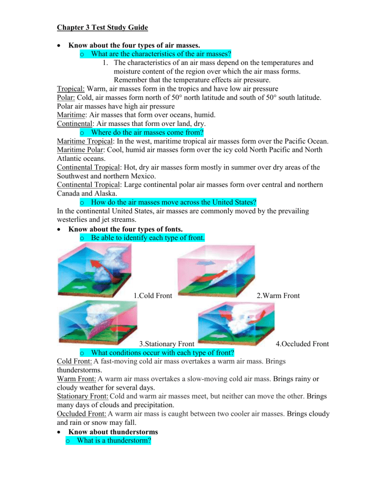
Know about the four types of fonts. o Be able to identify each type of front.
1.Cold Front 2.Warm Front
3.Stationary Front o What conditions occur with each type of front?
4.Occluded Front
Cold Front: A fast-moving cold air mass overtakes a warm air mass. Brings thunderstorms.
Warm Front: A warm air mass overtakes a slow-moving cold air mass.
Brings rainy or cloudy weather for several days.
Stationary Front: Cold and warm air masses meet, but neither can move the other.
Brings many days of clouds and precipitation.
Occluded Front: A warm air mass is caught between two cooler air masses.
Brings cloudy and rain or snow may fall.
Know about thunderstorms o What is a thunderstorm?
1.
A thunderstorm is a small storm often accompanied by heavy precipitation and frequent thunder and lightning. o How / when does a thunderstorm form?
How: A thunderstorm forms when warm, humid air rises rapidly within a cumulonimbus cloud.
When: Form in the spring and summer in southern states or on the Western Plains. o What should you do / not do during a thunderstorm?
Should do: Go inside avoid touching telephones, electrical appliances, or plumbing fixtures, all of which can conduct electricity.
Should not do: Seek shelter under a tree, if swimming continue to swim in the water or boat. o What cause lightning and thunder?
Lightning: Lightning is caused by a sudden spark, or electrical discharge, as these charges jump between parts of a cloud, between nearby clouds, or between a cloud and the ground.
Thunder: A lightning bolt can heat the air near it to as much as 30,000°C. The rapidly heated air expands suddenly and explosively, the explosive noise you hear is thunder, you see lightning before you hear thunder.
Know about tornadoes and hurricanes o How and where does a hurricane form?
How: A hurricane begins over warm ocean water as a low-pressure area, or tropical disturbance. If the tropical disturbance grows in size and strength, it becomes a tropical storm, which may then become a hurricane.
Where: A typical hurricane that strikes the United States forms in the Atlantic Ocean north of the equator in August, September, or October. o What are the different parts of a hurricane?
1.
At the center is a ring of clouds, called the eyewall. In the center of the hurricane is the calm “eye” where the sky becomes clear, and the air becomes calm. o What are some effects of a hurricane?
1.
Severe flooding as well as wind damage. It also brings storm surges,washing away beaches, destroying buildings along the coast, and eroding the coastlines. o What should you do during a tornado or hurricane?
1.
If you hear a hurricane warning and are told to evacuate, leave the area immediately. If you must stay in a house, move away from the windows.
Know about winter storms o What are the conditions necessary for snow?
1.
The air is colder than 0°C all the way to the ground, the precipitation falls as snow.
o What is lake effect snow and what causes it?
Lake Effect Snow: As cold dry air moves across the warmer water, it becomes more humid as water vapor evaporates from the lake surface. When the air reaches land and cools, lake-effect snow falls.
What Causes it: When a cold, dry air mass from central Canada moves southeast across one of the Great Lakes, it picks up water vapor and heat from the lake. As soon as the air mass reaches the other side of the lake, the air rises and cools again. The water vapor condenses and falls as snow. o Where does lake effect snow occur?
1.
Usually within 40 kilometers of the lake where the snow is from. o What should you do / not do during a winter storm?
Should do: Try to find shelter from the wind.
Should not do: When in a car keep the engine off
Know about reading weather maps. o What are isobars / isotherms?
Isobars: Are lines joining places on the map that have the same air pressure.
Isotherms: Are lines joining places that have the same temperature. o How do you read isobars and isotherms on a weather map?
2.
On some weather maps, you see curved lines. These lines connect places where certain conditions—temperature or air pressure—are the same.
How can you identify different types of fronts on a weather map? o How can you tell what direction a front is moving from a weather map?
3.
The simplified weather map on the next page includes most of the weather station data shown in the key o What do the different symbols on a weather map indicate?
4.
Standard symbols on weather maps show fronts, areas of high and low pressure, types of precipitation, and temperatures.
