LAND ADMINISTRATION IN HUNGARY
LAND ADMINISTRATION IN HUNGARY
1.1 Current situation - Land Office Sector within Hungary
The Hungarian Land Office Sector is responsible for the maintenance and updating of all land and property records throughout the country. The Department of Land and Mapping of the Ministry of Agriculture and
Regional Development (MoARD DLM) operates a national network of Land Offices, employing over 4600 personnel who maintain and update the property records which include both large scale (cadastral) maps and the legal and administrative records of the country. The Government acts as the legal guarantor of Title to property, a responsibility which is essential to ensure the safe and secure transfer of ownership in a free market economy. The economic transition process has exposed fundamental weaknesses in the existing Land
Registration System and many of these are being addressed through the EU PHARE Computerisation of Land
Offices Project.
The Land Office network operates on a three level hierarchical structure. The lowest level is the District Land
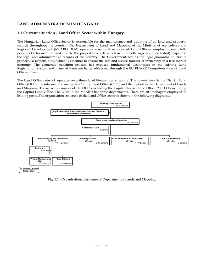
Office (DLO), the intermediate one is the County Land Office (CLO), and the highest is the Department of Lands and Mapping. The network consists of 116 DLO’s including the Capital District Land Office, 20 CLO’s including the Capital Land Office. The DLM in the MoARD has three departments. There are 300 managers employed in leading posts. The organisation structure of the Land Office sector is shown in the following diagrams.
Ministry of Agriculture
~500 persons
Land Privatisation & Consolidation, National Cadastre
Project Ministerial Commisioner
Department Lands and M apping
~30 persons
Secretary of DLM
1 person
Land Surveying and Informatics
Division
10-15 persons
Secretary
1 person
Land Registration
5-10 persons
Land Protection & Qualification
Division
5-10 persons
Project Management
Unit
~3 persons
Technical Advisers
Independen t
Case Officers
~10 persons
Fig. 1.1 - Organisational structure of Department of Lands and Mapping
Land Consolidation
Division
2 persons
--- 1 ---
Staff Development in Land Administration
1999/2000 Tempus Phare Joint European Project proposal
County Land Office
40-70 persons
Secretariat
1 or 3 persons
Land Registration Division
4-8 persons
Land Classification and Land Protection Division
2-5 persons
Financial and Economics Division
5-6 persons
Manual Staff
4-7 persons
IT Division (or Section)
2-4 persons
Surveying Division
15-20 persons
Supervision
1-3 persons
Fig. 1.2 - Organisational structure of a County Land Office
District Land Office
30-70 persons
Administration
5-10persons
Secretary, IT System Trustee, etc..
Manual and semi skilled
3-5 persons
Land Registration Section
10-30 persons
Land Classification and Land Protection Section
2-5 persons
Surveying Section
3-10 persons
Fig. 1.3 - Organisational structure of a District Land Office
As can be seen from the structural figures there are a large number of personnel of different skills and responsibilities working in the Land Administration area. CSLM and FÖMI have been involved within the educational and research & technological development programs for the Department of Lands and Mapping.
This is shown in the following diagram:
--- 2 ---
Staff Development in Land Administration
1999/2000 Tempus Phare Joint European Project proposal
Fig. 1.4 – CSLM and FÖMI act as basic institutions for the Land Office Sector
There is a demand for more technical and administrative based courses from both the staff and the management and this is a direct consequence of the strategic plan for the Department of Lands and Mapping. This demand also arises for the technological changes that have been introduced in the land offices network.
Major strategic aims of MoARD DLM to be completed include:
Making the introduction of new services possible
Increasing data sales by providing easy access to the land office data
Decreasing the overhead on the offices by encouraging applicants to use Intranet
Supporting business planning by providing a comprehensive accounts subsystem
Supporting Management Information System data-flow
Speeding up and decreasing the costs of the internal communication in the sector
Simplifying the Land Office processes by Electronic Mailing of Applications and introducing their automated processing
Raising the National IT level of awareness and application by encouraging technical developments built upon the new services of the sector
There has been an enormous technological change in the 1990’s. The Land Administration area within Hungary has benefited from these changes and has implemented them through a number of EU funded projects. These are outlined below.
1.2 Technological Developments in Land Administration
PHARE projects - KDIR, TAKAROS, TAKARNET, META
The economic transition process has exposed weaknesses in the existing land registration system in
Hungary and many of these are being addressed through the EU PHARE “Computerisation of Land
Offices” Project. The project aims to support the transition, providing a modernised land registration sector which will ensure safe and secure management of the land and property ownership records which consist of land administrative and legal records and cadastral maps. This project involves an estimated expenditure in excess of 15 million ECU and involves the complete reform and modernisation of the land registration system of Hungary during the period 1992 - 1998.
The Phare Programme has funded the supply of PC LANs, WAN equipment, peripherals and software to the 116 District Land Offices (DLO), 20 County Land Offices (CLO) including the capital CLO and CDLO as well as to educational centres and to FÖMI.
Fig. 1.5 - TAKARNET connects Land Offices building a global land information database for land administration
--- 3 ---
Staff Development in Land Administration
1999/2000 Tempus Phare Joint European Project proposal
Capital District
Land Office
Public
Access
(Phase I)
FÕMI
(Network Contol
Node + 1 site)
DLM (MoA)
CSLC
DLO 1.
Network Transport
Mechanism
(Frame Relay Service from
Telecom Company)
CLO 1.
DLO 115.
CLO 20
Fig. 1.6 - TAKARNET logical scheme
TAKAROS NETwork – provides Telecommunications and Network Infrastructure. This introduced a
FRAME RELAY type supply of connection sockets into each Land Office and provision of the data carrying service. The hardware and standard software needed by the Land Offices to connect between their LANs and the telecom supplier’s sockets as well as the installation of these systems. It also includes a security ‘Firewall’ system, a network management system and a computer for setting up the external data services. It operates through an interface similar to that of the World Wide Web and some WWW based software applications.
In the next stage of the PHARE project Land Information Systems will be introduced in the County
(Regional) Land Offices. This will be responsible for establishing database services in support of agriculture and environmental monitoring (including crop and land cover), national agrostatistics, and will also be responsible for land reorganisation and land consolidation. These systems will require deeper understanding of LIS on technical and procedural level, considerably more management knowledge and are likely to require significant skills in project management, product development and marketing.
Learning Resource Centres in 20 CLOs
Included within the TAKAROS budget for 1998 is a figure of 600 000 ECU for the development of learning resource centres in the County Land Offices. This budget will greatly benefit the educational resource support for the distance learning portion of the proposed SDiLA project (see attached letter from Dr Laszlo Niklasz, ministerial commissioner, PHARE project manager).
MEgyei TAkaros (County TAKAROS). This is the final step of the overall TAKAROS development. META enables CLO to provide technical support to DLO such as help desk and background data processing. META completes the missing interfaces of the overall TAKAROS system. META introduces an MIS system for the sector. Major Strategy aims to be completed:
Increasing the reliability and safety of the DLO by technical support, archiving and being able to replace any DLO in case of disaster
Supporting the Land Mortgage Institute
Increasing potential income by being able to create new GIS data products
Supporting Local Authorities by providing access to GIS data sets
Raising the National IT level of awareness and application by encouraging technical developments built upon the new services of the sectors
--- 4 ---
Staff Development in Land Administration
1999/2000 Tempus Phare Joint European Project proposal
Supporting National Mapping activities by providing Automated Cadastral Maps. Quality
Controlling and Accepting data for the Generation of TAKAROS DLO data sets with replacement map data
Supporting the EU membership by providing land use and land qualification monitoring features
Stimulating the land market by providing thematic maps and support for Land Qualification and
Valuation
Supporting the Land Tax by creating thematic GIS data sets and making them available by Intranet
The Hungarian Land Registration is a modern multi-purpose system which performs the task of the
“Grundbuch” system, the Cadastre system, the land use and qualification systems and is also used for land valuation. The system has to deliver the following national requirements:
Providing security of titles
Supporting the Mortgage Institute
Supporting Land Compensation and Privatisation
Stimulating the Land Market
Providing Data for Taxation Purposes
Providing Data for Urban Planning
Providing Data for Utility Registration
Providing Data for Agricultural Planning
Providing Data for other National Services (e.g.: Forestry, Hydrology etc.)
Providing Data for the National Statistics
Providing Data for the Local Authorities
Providing ‘Positive’ registration and a guarantee of the registered data
The modernisation of the sector will achieve the following purposes:
Increasing legal security
The Land Office procedures need to be made faster
The risk of the possible corruption must be minimised
The safety and reliability of the system must be increased
The procedures must be made simpler
The administrative system must be auditable and transparent
Supporting Privatisation (Land Compensation, Co-operative Sharing)
A Large number of cases must be dealt with
The Land Office must be able to monitor actual land use
The Land Office must be able to receive rent
The forthcoming land consolidation must be supported
Increasing the financial predictability and safety of the operation
The Sector must increase returns with value added services
The Sector must increasing returns with totally new services
The Sector must try to achieving self financing status
The Sector must agree shared cost GIS projects with other parties
The current 'duty stamp' charging must be replaced with 'direct service fees'
Supporting the National IT Strategy
The Sector must continue to be a leading force for the National LIS
The sector will support GIS projects
The Sector will develop new Standards
The Sector may introducing temporary regulations where standards are not applicable
The Sector will support the implementation of modern technologies
The Sector will provide data in electronic form
Supporting new requirements for planned EU membership
The Sector provides statistical information concerning land use and ownership structure.
The Sector acts as the competent National Mapping Agency in pan-European and other international forums.
Standardisation – DAT (funding body – National Committee for R&TD)
--- 5 ---
Staff Development in Land Administration
1999/2000 Tempus Phare Joint European Project proposal
The subject of the standard is a conceptual model of the digital base map (DAT) encompassing the aims of
Hungary's surveying large scale maps. DAT is a computer-aided ‘true’ form representation of data of parcels, according to the requirements fixed in this standard. DAT is part of the Uniform National Map System
(EOTR). It is compatible from above with former surveying large scale maps at scales 1:1000 – 1:4000 from the point of view of information technology, content and data quality.
National Cadastre Program (funding by governmental loan)
The technical and financial documents of the National Cadastre Programme have been elaborated focusing on the following items:
Accelerating the data entry of the land registration records,
Starting the renewal in and new measurements needed for the large-scale mapping providing geometric template for land registration and for a wide range of applications
Education, training and management.
The implementation of additional planned actions, having impact on the National Cadastre Programme is scheduled using a priority scenario:
Continuation of the pilot project Land Re-organisation and Consolidation
Establishment of the land-use information system based on pilot project and nomenclature harmonisation
Large scale digital mapping in 1:10000 scale range
Land valuation
The project is financed with international funds. The technology development for the certification and quality acceptance test of cadastral maps as well as regulation on the data exchange format is under elaboration, mostly in harmonised activity with the respective CEN and ISO Technological Committees.
Gathering the administrative boundary information based on surveyed co-ordinates is in progress. The database will be also used in statistics, regional planning and agricultural/land related management.
Integrated Administrative Control System – IACS (PHARE project, under preparation)
The aim of the system is to support parcel-based information about the use of the agricultural land in order to make certain the agricultural aid was allocated in a reasonable manner. An IACS pilot project will be started in June 1998 on two study areas where the control system of the agricultural aids will be developed.
The pilot project area covers 4000 ha. The system contains a land use-monitoring system, developed by FÖMI
Remote Sensing Centre, and a land information system, which acts like the IACS frame. The pilot project will be carried out in 20 months.
One-stop-shop and National Clearinghouse - metadata project (Prime Minister`s Office)
According to principle of the "one stop shop" there were developed a customer office facility which makes the process of registration of building authority cases applications easier. This facility will be based on Land
Offices and local government GIS databases. The TAKARNET system will allow the local governments, other state or regional offices, public notaries, bank officers, lawyers, private surveyors etc.
To look into the property sheet
To let make a copy from the property sheet and cadastral map
The National Clearinghouse - metadata project is aimed to build the basic digital data inventory. Metadata services will widen the field of GIS applications and enlarge the number of GIS users.
These above mentioned services need well educated staff in the Land Administration in different institutions of
Hungary. However the lack of a developed education and training facilities within the country in the specific areas of Land Administration and Land Information Systems could limit the projects success.
1.3 Educational Developments and Activities
Alongside the technical projects there have been a number of educational initiatives. The chief amongst these initiatives has undoubtedly been the Open Learning in Land Offices (OLLO) TEMPUS SJEP which laid the foundations for distance learning within the Land Offices. The OLLO TEMPUS SJEP (1995-98) - co-ordinated by
CSLM - was a first attempt to satisfy the educational requirement of the Land Office personnel but this project
--- 6 ---
Staff Development in Land Administration
1999/2000 Tempus Phare Joint European Project proposal satisfied mainly the requirements of the professional level staff through development of post-graduate courses.
OLLO - TEMPUS SJEP
OLLO was formed through the co-operation of the CSLM, the Department of Lands and Mapping at the
Ministry of Agriculture and Regional Development (MoARD DLM), the University of Veszprém (UV), the
University of East London (UeL) and the Katholieke Universteit, Leuven (KUL). The aim of OLLO TEMPUS
Project was to provide the essential educational background of the PHARE projects in Land Offices. The importance for training, updating and upgrading of human resources in Land Offices is evident. However
Land Office staff are working, and could not afford to make a long break for educational purposes. Distance learning was therefore chosen as the delivery method.
For the staff of Land Offices distance learning offers a particularly flexible and effective way of training, eliminating most of the barriers, providing much better accessibility than traditional education:
anyone from the Land Office staff can enrol for the scheme
OLLO students can choose their own route, select the appropriate module(s)
they can learn anywhere in the country
the course is flexible in time, students can learn any day, any time that suits them
they can set their own pace
they will be able to choose from a range of learner support.
Table 1.1. Principal study areas and modules
Infrastructure
Land and Property Registration
Office Automation
Information Systems
Management
Management and Data Policy
Project Management
Quality Management
Legal issues
Introduction to Management
Data issues
Digital Data Acquisition
Digital Large Scale Mapping
Land Use Management
Applications
Multipurpose Cadastre
GIS/LIS Applications
Land Reorganisation & Consolidation
Much of the content of the OLLO study modules relates to fundamental issues of professional work, management, use of data and information technology. These are subjects of central concern to any organisation or country which has to go through similar processes of change to that which Hungary has experienced. The demands on, and concerns of, professional staff are common factors which emerge alongside the updating of the land registration sector as it develops to support effective land markets and economies. Looking to the future it is apparent that the valuable teaching resource and development experience created by the OLLO project should to be available to others going through the processes of change OLLO has addressed.
1.4 EU integration
MoARD DLM as the Hungarian Land and Mapping authority has identified a number of areas where it will need to develop in order to work towards EU harmonisation. These relate strongly to the benefits of computer technology and are the culmination of the continuing managerial educational and organisational improvements of the last five years.
Proposed actions to EU harmonisation:
Developments by introducing EU-harmonised, GIS based services
--- 7 ---
Staff Development in Land Administration
1999/2000 Tempus Phare Joint European Project proposal
EU conformable reporting and presentation on rural development, agro-environment etc.
Maintaining the authentic administrative boundary database as needed for NUTS1-NUTS5 level territorial multipurpose analysis related to rural development and delineation of less favoured areas
Renewal of analogue large-scale maps needed by land registration and land information system
Strengthening the property ownership security via computerised, client friendly land registration services,
Introduce EU conformable legal environment i.e. laws, regulations and standards in order to apply the
acquis, and identified elements essential in the land administration.
Progression towards national and international networking .
Taking part in the work of EU institutions, for instance CERCO, MEGRIN, GISIG, EUROGI etc.
The ongoing multi-year PHARE project on "Computerisation of the Land Offices" and the proposed
"Technical support of the integrated rural developments by GIS services" as well as the National Cadastre
Program's subprojects fully support the achievement of these goals and objectives. Table 1.2. indicates the proposed actions. The proposed SDiLA project is essential for the Land Office staff to satisfy these demands and very important also for state administration, because a number of local governments and administrative offices will connect to the Land Offices through the TAKARNET network in the near future
(see letter of endorsement written by Mrs Zöldné Roska Marietta, deputy state secretary, Prime Ministers
Office).
1.5 Project Objectives
The long-term objective is to maintain, during the period of EU harmonisation and beyond, the role established by CSLM as a national centre of excellence in the provision of professional education to the land administration sector in Hungary. CSLM is an internationally recognised centre of professional and technology oriented education, in land surveying with long experience of educating Hungarian professional land administration staff. The College is a base for the dissemination of practitioner knowledge and skills in the wider fields of handling land related information.
The goals of CSLM may be formulated in the following concepts:
Developing the academic and professional programmes in both quality and quantity;
Increasing the flexibility of the curriculum structure; improving the quality of teaching;
Ensuring openness and responsiveness to the needs of the society;
Ensuring that all learning resources which support academic and research programmes are kept up to date and relevant
Maintenance and development of national and international co-operation in research and education based on mutual benefits;
Widening the scope of surveying education and research to take account of the inter-disciplinary concerns of the professional surveyor
The proposed SDiLA project completely supports the strategic aims of the development plan of CSLM and will ensure that these aims are met during the period of harmonisation and beyond.
There are three project objectives to support the long-term objective. First, the creation of a programme of education for continuing professional development for Land Administration in Hungary based on existing programmes developed under the TEMPUS OLLO Project and other projects in Hungary and the EU.
These will utilise the existing Land Administration infrastructure. To these will be added new programmes for higher management and a set of programmes for all levels in Land Administration focusing on organisational issues, on skills and on matters pertinent to EU entry. In seeking to achieve these objectives, the project will develop a core base of knowledge in land administration matters, the
Knowledge Pool, which can be used in a flexible manner as a part of staff development programme tailored to individual's requirements. By building on the highly successful OLLO (Open Learning for Land Offices in Hungary) Structural Joint European Project the project will create an even more flexible and widely applicable staff development resource that can be used by individuals from many civil service disciplines.
The provision of such a resource is essential for adequate staff development to support staff preparing for
--- 8 ---
Staff Development in Land Administration
1999/2000 Tempus Phare Joint European Project proposal
Hungary's accession to the EU and the consequent demands this will place upon them. The proposed
SDiLA TEMPUS Institution Building project would update / improve the structure and develop 3 OKJ short courses, and a general management course in land administration.
Second, the creation of a delivery system for continuing professional development based on a management system and education technology, both CD and Web, with a comprehensive credit system.
The operation of a knowledge pool will depend on the creation of a database of education resources and on a metadata system that will provide the flexibility needed for supporting professional development.
The specifications for such systems are becoming available from the Instructional Management Systems
(IMS) initiative and compliant databases are already available from the project partners. CSLM and the project partners already have considerable experience of the education technology needed to deliver the proposed programme. The UNIGIS network of universities is a major provider of professional education and an active developer of web and other education technologies that are available to this project. These will be adapted to the specific requirements of the Hungarian Land Administration system.
Third, the creation of a network of EU centres and education providers with the objective of participating fully in EU activities in Land Administration and the EU professional community. The partner institutions are each active in the field of professional development and there are other institutions in the EU which have long standing links with CSLM. This network will be used to establish the dialogue necessary for planning the maintenance of quality in professional practice throughout the EU. The Land Administration professions are undergoing rapid change because of the radical changes in technology and there is a continuing need for the professions to retool and adapt. Changing standards and practice at EU level requires continuous updating. Against this background the project seeks as part of its exit strategy to put in place the channels of communication and the modus operandi for the necessary dialogue between professional and educational bodies in the EU and Hungary.
1.6 Target Groups
Target groups are civil servants in administrative, technician and managerial level in land and cartographic administration. The project is seen as being a key element in the harmonisation process within land administration and will act as medium for furthering EU harmonisation.
These staff are working:-
in the land offices (using TAKARNET),
in other administrative sectors including local governments, ministries, public notaries, lawyers, bank officers etc. working with the land related data in their profession (using computers more and more frequently Internet).
Target groups can be divided into the following four categories:
administrative,
professionals,
technician,
management.
--- 9 ---
Staff Development in Land Administration
1999/2000 Tempus Phare Joint European Project proposal
Fig. 1.7 - Target groups and professional levels
CSLM is the basic institution for the education and training of the Land Offices`s staff (see endorsement letter of Mr Geza Apagyi, head of MoARD DLM and CSLM’s DEED OF FOUNDATION). The SDiLA
Institution Building TEMPUS project will enlarge the existing tutoring network with 8 tutors and 40 mentors, which enables this newly developed knowledge centre to highly increase the number of trainees. In the pilot training courses SDiLA will retrain 120 land administrators, 60 technicians in lands and mapping and 40 senior managers.
--- 10 ---
Staff Development in Land Administration
1999/2000 Tempus Phare Joint European Project proposal
Designation of Tasks
A) Working out a model system of remote sensing based and
EU harmonised agricultural support control and other territorial information data handing over for country-wide
GIS: 1. Shaping and testing of checking system with remote sensing methods in the test area
2. Examination of information providing from deduced remote sensed data in the test area
B) Fulfilling of administrative boundary database, leading in the service, connection to GISCO/NUTS, SABE and PETIT
EU programmes
C) Working out of Digital Topographic Map Standard
D) Creating and settling a digital topographic database for the regional GIS to the County Land Offices ( 2
E) Tasks in the Annex of Decision of Government
No.:2339/1996. (XII.6.):
Creation from period of 1984-86
1.
National, 1: 50 000, CORINE land-cover mapping
2.
National, 1:100 000 CORINE database
F) Strengthening of reception willingness for utilisation services of land administration and mapping (1 st part)
G) Renewal of the land administrational and mapping data on future boundary of EC which accords to the outside boundary of Hungary (and on the Austrian-Hungarian common boundary, too)
H) To be in official connection with European professional organizations nd part )
I) Adaptation of European pre-standards ( 6 items )
Motivation
Table 1.2. EU harmonised tasks in the year 1997-98, Department of Lands and Mapping
Preparations for joining to EU. Execution of two connected, governmental pilot project for agricultural support control and information providing with remote sensing methods in the frame "Development of parcel based .information system for supporting, regulation and controlling of agriculture"
Remark: In tasks of pilot project there is not any overlapping with NÖVMON programme but satellite photos of NÖVMON programme are used in pilot project, too. It means the low level of costs of the pilot project
Development of active participation in MEGRIN work group
Development of EU compatible Digital Topographic Standard according with the proposals and aims of CERCO
The continuation and finishing of the already ongoing project in frame of EU harmonisation for the purpose of development of the Land administration and
Mapping Branch. The planned database could be used in the agriculture (e.g. slope category)
The database provides a basic background information for solutions of agricultural environmental, regional developmental and environment protection tasks in connection with the EU joining.
It bases the long terminal analysis with the existing database for the term 1990-1992.
It insures the EU harmonised marketing introduction of the IT developments based
(since 1992) and continuously modernised land administrational and mapping services.
The modernisation of the land administrational and mapping data in the whole
Hungarian boundary zone are prepared and begun by the National Surveying Branch harmonised with Surveying Service of the Home Defence and mapping organisations of the neighbour countries. This work must be finished by the time of joining.
Membership and collaboration in the European organisations of Land Administration
(MOLA), Mapping (CERCO), and GIS (EUROGI).
The EU has not official mapping law, the harmonisation can be ensured by the six
CEN-pre-standards
Place of Usage
FÖMI
MoARD DLM
MoARD, FÖMI
FÖMI, County
Land Offices
MoARD,
Ministry of
Environment and
Nature Protection
MoARD, FÖMI
MoARD, FÖMI,
Land Offices
MoARD, FÖMI
MoARD, FÖMI
--- 11 ---
Staff Development in Land Administration
1999/2000 Tempus Phare Joint European Project proposal
A Strategic Committee for Staff Development in Land Offices was formed by the head of MoARD
DLM in 1997. It was recognised by MoARD DLM that human resources were the most important aspect of service delivery in Land Administration. When the speed of change in information technology is placed alongside the transition changes of land ownership and measurement within
Hungary, a need for education and training has become paramount. The educational system must be made more responsive to the customer and, with this in mind, a system of open and, very often, distance education was proposed.
For the staff of Land Offices distance learning offers a particularly flexible and effective way of training, eliminating most of the barriers, providing much better accessibility than traditional education. That is why distance learning with Internet support (TAKARNET) will be used for course delivery with an extension by additional workshops for practical work and consultations.
The Technical High Schools in Land Surveying are the official examination sites for the administrative and technician OKJ short courses.
The Committee also produced a questionnaire to assess the land office staff requirements and demand for education and training. The major items addressed were the following:
1. Personal, professional development
Personal education in the last five years
Requirement for different types of staff development
2. Computer knowledge
Computer skills
Computer program usage
Requirement for computer usage skill development
3. Foreign languages
Foreign language skill
Demand on foreign language learning
The number of people in sample 4428, replied 2356 ( 53%). The following are some pie charts and tables of the responses:
--- 12 ---
Staff Development in Land Administration
1999/2000 Tempus Phare Joint European Project proposal
These charts clearly indicate the requirements for technical, administrative and language, managerial courses.

