Penycloddiau Hillfort, Flintshire
advertisement
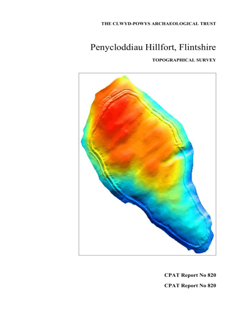
THE CLWYD-POWYS ARCHAEOLOGICAL TRUST Penycloddiau Hillfort, Flintshire TOPOGRAPHICAL SURVEY CPAT Report No 820 CPAT Report No 820 Penycloddiau Hillfort, Flintshire TOPOGRAPHICAL SURVEY N Jones October 2006 Report for Denbighshire County Council The Clwyd-Powys Archaeological Trust 7a Church Street, Welshpool, Powys, SY21 7DL tel (01938) 553670, fax (01938) 552179 © CPAT CPAT Report Record Report and status CPAT Report Title Penycloddiau Hillfort, Flintshire: Topographical Survey CPAT Project Name Penycloddiau CPAT Project No 1393 CPAT Report No 820 Confidential (yes/no) No draft/final Final Internal control name signature date prepared by N W Jones 20/10/06 checked by R.J. Silvester 20/10/06 approved by R.J. Silvester 20/10/06 Revisions no date made by Internal memo The Clwyd-Powys Archaeological Trust 7a Church Street Welshpool Powys SY21 7DL tel (01938) 553670, fax 552179 © CPAT checked by approved by CPAT Report No 820 page CONTENTS 1 INTRODUCTION 2 LOCATION, GEOLOGY AND VEGETATION 3 METHODOLOGY 4 TOPOGRAPHICAL SURVEY 5 CONCLUSIONS 6 ACKNOWLEDGEMENTS 7 REFERENCES Fig. 1 Previous survey areas and area of heather burning 2003 Fig. 2 Topographical survey with contours at 0.5m intervals Fig. 3 Areas of potential occupation Fig. 4 False-colour relief-shade model Fig. 5 Grey-scale relief-shade model Fig. 6 Rampart profiles 1 CPAT Report No 820 page 2 1 INTRODUCTION 1.1 In May 2006 the Field Services Section of the Clwyd-Powys Archaeological Trust (CPAT) was invited by Denbighshire Countryside Service to produce a quotation and specification for a topographical survey of Penycloddiau Hillfort (SAM Fl 009), as part of the Heather and Hillforts Project. The specification and quotation were accepted and the survey was undertaken between July and October 2006. 1.2 Two previous surveys at Penycloddiau had already been conducted by CPAT (see Fig. 1), the results from which were incorporated into the present survey. In 2000 a small-scale survey was undertaken around the southern entrance and along the northern defences in connection with erosion control works along the Offa’s Dyke footpath, which follows the ridge through the hillfort. This was followed in 2004 by a more extensive survey after extensive heather burning during April 2003 which provided an opportunity to undertake detailed recording of features newly revealed by the loss of vegetation. 1.3 A geophysical survey was also undertaken in 2004, the results of which revealed a number of anomalies which corresponded to visible earthworks, together with other features which may be related to variations in the geology or pedology (Donaldson 2004). 2 LOCATION, GEOLOGY AND VEGETATION 2.1 Penycloddiau is the largest of the six hillforts in the Clwydian Range Area of Outstanding Natural Beauty (AONB). The hillfort lies on the central ridge of the Clwydians, between the Wheeler Valley and the Vale of Clwyd, which at this point rises to an altitude of around 440m OD (SJ 128676). The inner western rampart forms the county boundary between Flintshire and Denbighshire. 2.2 Penycloddiau is one of the largest hillforts in Wales, with the defences enclosing an area of around 20 ha. The hillfort is multivallate, with a continuous inner rampart and discontinuous outer rampart, together with additional outer defences at the northern end. 2.4 Much of the hillfort is covered with heather, a significant area of which was affected by a fire between 30 March and 1 April 2003. Subsequent aerial reconnaissance by the Royal Commission on the Ancient and Historical Monuments of Wales (RCAHMW) helped to define the extent of the heather burning and also revealed the potential for newly revealed interior features. 2.5 A significant area of the western ramparts is covered with dense gorse, bramble and scrub vegetation which proved to be a considerable hindrance to the topographical survey. By contrast, the eastern ramparts are partly covered by bracken although this did not affect the survey. 2.6 The soils consist of well-drained loams and thin peat, overlying Palaeozoic siltstone. 3 METHODOLOGY 3.1 The topographical survey was conducted using a Wild TC500 EDM in conjunction with Penmap survey software. The survey included the top and bottom of all features, the limits of footpaths and modern boundaries, together with spot heights. Reading were taken at appropriate intervals, normally around 7m apart, with sufficient points to allow a digital terrain model (DTM) to be produced of the area. All levels were related to Ordnance Datum with reference to a bench mark depicted on the Ordnance Survey 1:2,500 1st edition map. CPAT Report No 820 page 3 3.2 Post-survey processing employed AutoCAD13 to position the survey data against the Ordnance Survey National Grid, achieved as a best fit against plotted boundaries. The survey data, including that undertaken in 2000 and 2004, have been processed using Penmap survey software to create a series of contour models with contours at 0.5m (Fig. 2), 1m, 2m and 5m intervals, and using Mapinfo Vertical Mapper to produce a relief shade model (Figs 4 and 5). Digital data resulting from the survey have been passed to Denbighshire County Council in a GIS compatible format. 4 TOPOGRAPHICAL SURVEY (Fig. 2) 4.1 The interior of the hillfort occupies 19.8ha, while the circuit of the main rampart extends for 1.93km. The hillfort occupies a prominent position crowning a large hilltop, the axis of which is north-west to southeast. Within the interior the topography is undulating, with a series of low ridges and hollows running roughly north-east to south-west (see Figs 4 and 5), the ground falling by around 44m from the highest point inside the northern ramparts to the southern entrance. 4.2 4.3 4.4 Hillfort entrances Penycloddiau has two original entrances, and there are a number of more recent breaks in the defences. The southern entrance guards the approach from the col between Penycloddiau and Moel Arthur. Although the earthworks have been disturbed, the inturned banks are still clearly visible creating an entrance up to 5m wide, within which the modern path has exposed some stone which is suggestive of a structure. On the north-east side there is a small hollow with a surrounding bank against the inturned bank, behind which a large quarry scoop may well have been utilised as a hut platform. On the western side there is a more level area between the inturned bank and the interior quarry ditch for the main rampart which has slight earthworks suggesting the position of a round hut. The eastern entrance lies approximately midway along the eastern defences, c.500m from the southern entrance. This also has inturned banks, together with an additional outer defence which flanks the southern side of the approach at the top of a steep-sided dry valley. On the northern side of the approach the defences have an additional bank and ditch (see 4.8 below). In the interior, to the north of the track, there is a levelled area which may have been the position for a round hut, and a prominent, rounded area in the base of the quarry ditch on this side is also rather suggestive. Ramparts In general the ramparts are fairly well preserved, although the western side has been damaged in the past by the construction of a boundary wall and the eastern side, to the south of the entrance, has suffered some collapse down the steep slope. Much of the circuit comprises a single, often very substantial rampart with an internal quarry ditch and an external ditch with a counterscarp around most of the northern end of the hillfort. The defences were augmented with additional banks and ditches in association with both entrances, as well as where the topography lessened the natural defences of the hilltop. 4.5 At the southern end, to the west of the entrance, the defences consist of the main rampart, which has been disturbed by the construction of the boundary wall, on the inside of which is an irregular quarry ditch, the nature of which suggests that a number of huts may well have been sited within it at various points. The external ditch is now largely infilled and survives as a level terrace contouring the hill some 8m below the crest of the rampart. Immediately to the west of the southern entrance there is an additional intermediate bank and ditch which runs north-west for approximately 110m before petering out (Fig. 6, Profile 1). 4.6 Near the midpoint along the western side the defences are breached by a modern track. From a point some 50m to the south-east an outer bank is evident beyond the ditch which continues to the CPAT Report No 820 page 4 north-west, becoming more pronounced (Fig. 6, Profiles 2 and 3). To the north-west of the breach the internal quarry ditch takes the form of a series of scoops, one of which contains clear traces of a structure, and it is likely that at least some of the others also contained huts. Close to the northwest corner another track, of greater antiquity, crosses the defences, breaching the counterscarp and main rampart and is represented by a causeway infilling the outer ditch and quarry ditch. 4.7 At the northern of the hillfort the defences are more elaborate, reflecting the relatively easy approach along the ridge from the north-west. Although there is no entrance here, the route has been adopted by the Offa’s Dyke path which traverses the defences and has led to considerable erosion in the past, necessitating the construction of timber and stone steps. An intermediate bank and ditch are present for a distance of c.160m, together with a discontinuous outer bank and ditch which extend for around 110m (Fig. 6, Profiles 6 and 7). Just to the west of the northern tip of the defences a former track is visible, breaching the outer ramparts and partly infilling the ditches. The quarry ditch again has numerous scoops which may have been utilised as hut platforms. 4.8 Along the north-east side the intermediate defences peter out, leaving the main rampart with an outer ditch and a fairly substantial counterscarp bank (Fig. 6, Profiles 7 and 8). A farm track breaches the defences c.210m from the northern end and although some sources have suggested that this could have been original, acting as a sally port (Davies 1949, 272), it seems more likely that this is relatively modern. Just to the north-west of the track, and continuing to its south-east, there is an intermediate bank and ditch which extends as far as the eastern entrance (Fig. 6, Profile 9). 4.9 To the south of the eastern entrance the defences cross a prominent, steep-sided, dry valley which extends some way into the interior. The rampart at this point is surprisingly slight, although there has evidently been some collapse and spread of the bank into the depression. A level terrace below the rampart suggests an infilled ditch which can be traced for a short distance before it merges into the steep natural slope (Fig. 6, Profile 10). 4.10 To the south of the dry valley the steep hill slope was evidently considered to be a good natural defence, since the rampart is generally fairly slight with an internal quarry ditch and low bank, but no external ditch (Fig. 6, Profile 11). At the south-east corner the defences lie above a rock outcrop which appears to have been partly enhanced as a result of small-scale quarrying. Internal features and occupation 4.11 Within the hillfort interior the survey has identified 33 certain or potential round-hut platforms which have visible earthworks, most of them are terraced into the natural hill slope. In addition, a number of areas have been identified where it is considered likely that huts could have been located as a result of their sheltered position and the relatively level ground. A further 49 roughly circular hollows have been identified in the lee of the ramparts which could have contained huts, together with a number of less convincing hollows which may simply be quarry scoops for the construction of the rampart (Fig. 3). 4.12 Excluding those within the quarry ditch, the round-hut platforms form three main groups on the north-eastern side of the hillfort, each taking advantage of the local topography to exploit the most sheltered positions. In the north-east corner of the hillfort six potential platforms were identified occupying a natural hollow, while to the south-east a further seven were located close to two shallow, seasonal ponds and within an adjacent hollow to the east. A small artificial pond was also recorded within the latter group, possibly having been excavated as a well. A further group of eight platforms was identified close to the farm track, one on the north-west side and the rest to the south-east. 4.13 In the centre of the hillfort two potential platforms were identified on the south and east sides of a low natural rise, with a further two possible sites located near the south-east corner. On the CPAT Report No 820 page 5 western side of the hillfort a single platform was recorded overlooking an area where the quarry ditch was thought to contain a number of potential hut sites. 4.14 The majority of the hillfort interior has a thin peat covering which has presumably developed since the Iron Age and this, together with an element of hill wash, has in part masked some of the archaeological features within the area. Combined with the dense heather it is therefore not surprising that most of the features revealed by the survey had not been previously recognised. 4.15 The highest point of Penycloddiau is occupied by a small cairn (PRN 102277) which measures 5.2m in diameter and 0.4m high, and is being actively eroded by the Offa’s Dyke footpath on the east side, and has a walkers’ cairn on the summit. The cairn is generally composed of small stone in a soil matrix and it has been suggested that it may be a denuded Bronze Age burial cairn. Indeed, in the 19th-century account of the hillfort in Lewis’s Topographical Dictionary of Wales he recorded that ‘in the centre of the camp is a large tumulus’. Ellis Davies (1949, 273), however, favoured an interpretation of the cairn as a boundary marker between the parishes of Ysgeifiog and Llandyrnog (the parish boundary now follows the western rampart). An inspection of the Ordnance Survey 1st edition 1:2,500 map published in 1871 clearly shows a triangulation station at this point, with the parish boundary running slightly to the east (a second triangulation station is also shown towards the southern end of the hillfort at SJ 13126729). Despite this evidence there remains the possibility that the origins of the cairn lie in the Bronze Age and only trial excavation can determine its likely date and function. 4.16 A small mound (PRN 102276) which may be attributed a boundary function with more certainty lies in the north-western part of the interior (SJ 12776768) and was identified as such by the Ordnance Survey in 1871). Although a number of other boundary mounds are also recorded, none was identified during the present survey. 4.17 At the southern end of the hillfort is an area containing numerous small hollows, some with adjacent mounds, which are now thought to be the remains of small-scale quarrying of unknown date. 5 CONCLUSIONS 5.1 The topographical survey has revealed significant new information regarding the interior of the hillfort and in particular has identified a number of previously unrecorded earthworks likely to represent round-hut platforms. Including the results from the 2004 survey, 82 potential platforms have now been identified, 33 of which lie within the interior and a further 49 are situated in the lee of the ramparts. As one might expect the majority of platforms occupy the more sheltered areas of the hillfort, particularly on the north-east of the interior. 5.2 The heather burning in 2003 provided an invaluable opportunity to examine a significant area of the hillfort interior in detail and although the present survey has identified new internal details it is likely that further, as yet unidentified platforms may be located in areas where dense heather remains. The survey has, however, enabled a better appreciation of the topography and its relationship to the occupation of the hillfort. 5.3 Although the circuit of the ramparts had already been planned by the Ordnance Survey the present study has provided a considerably more detailed record, revealing new information about the defences. In particular, the defences can now be studied in relation to the topography and the series of profiles clearly demonstrate not only the variation in the defensive circuit but also how the natural slope has been adapted. CPAT Report No 820 page 6 CPAT Report No 820 page 7 6 ACKNOWLEDGEMENTS 6.1 I would like to thank the following people for their assistance during the project: Wendy Owen and Brian Williams, CPAT; and Fiona Gale and Helen Mrowiec, Denbighshire Countryside Service. 7 REFERENCES Published sources Davies, E, 1949, The Prehistoric and Roman Remains of Flintshire. Cardiff. Lewis, S, 1833. A Topographical Dictionary of Wales 2 Vols. London: S. Lewis and Co. RCAHMW, 1912. An Inventory of the Ancient Monuments in Wales and Monmouthshire: II County of Flint. London: HMSO. Unpublished sources Donaldson, K T, 2004. Pen y Cloddiau Hillfort, Flintshire: Geophysical Survey Report. Stratascan J1828. Jones, N, 2004. Penycloddiau Hillfort, Flintshire: archaeological survey. CPAT Report No. 631. Cartographic sources Ordnance Survey 1st edition 1:2,500, Flintshire 8.15, published 1871. CPAT Report No 820 page APPENDIX 1 SITE ARCHIVE Digital data Mapinfo tables (with dxf and AutoCAD13 files) pycsurv survey earthworks pycnodes survey points 0-5cont 0.5m contours 1mcont 1m contours 2mcont 2m contours 5mcont 5m contours Mapinfo tables (with dxf files only) heather extent of heather burning 2003 occupation extent of possible occupation survey previous survey areas geophys geophysical survey area Penmap survey and dxf file Pyc06 8
