Hurricane Season is Heating Up
advertisement
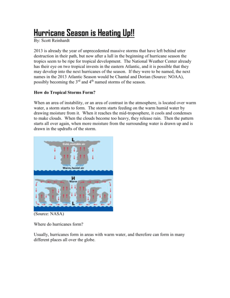
Hurricane Season is Heating Up!! By: Scott Reinhardt 2013 is already the year of unprecedented massive storms that have left behind utter destruction in their path, but now after a lull in the beginning of hurricane season the tropics seem to be ripe for tropical development. The National Weather Center already has their eye on two tropical invests in the eastern Atlantic, and it is possible that they may develop into the next hurricanes of the season. If they were to be named, the next names in the 2013 Atlantic Season would be Chantal and Dorian (Source: NOAA), possibly becoming the 3rd and 4th named storms of the season. How do Tropical Storms Form? When an area of instability, or an area of contrast in the atmosphere, is located over warm water, a storm starts to form. The storm starts feeding on the warm humid water by drawing moisture from it. When it reaches the mid-troposphere, it cools and condenses to make clouds. When the clouds become too heavy, they release rain. Then the pattern starts all over again, when more moisture from the surrounding water is drawn up and is drawn in the updrafts of the storm. (Source: NASA) Where do hurricanes form? Usually, hurricanes form in areas with warm water, and therefore can form in many different places all over the globe. Places where Tropical Cyclones are Common (Source: NASA) Is this year’s hurricane season going to be an “active” one? The first factor in my opinion for predicting a hurricane season is warm ocean temperatures in the doldrums and in the tropics. “Sea Surface Temperature (SST) Contour Charts” (Source: NOAA Office of Satellite and Product Operations) As you can see from the picture above, there is a large area of warm water in the doldrums and the tropics. These areas are in the upper 20’s of degrees Celsius, which is about 78.8 degrees Fahrenheit to 84.2 degrees Fahrenheit. These temperatures are necessary for a storm to form, because it also helps to support the humid air. (Source: arizona.edu) Warmer water evaporating from the ocean means more humid air, according to the above graphic, which leads to bigger, more severe storms. According to NOAA, this July has been the “Second Warmest July and Warmest Year-to-Date Global Temperature on Record.” When you have hotter air temperatures, the water temperature slowly starts to heat up, making the atmosphere more favorable for tropical development. The normal difference between how fast water heats up and how fast land heats up is shown below. (Source: http://noconsensus.wordpress.com/2011/04/05/234-5/) The above diagram shows that the temperatures of the water are related to the temperatures of the air, further proving my point that when you have hotter air temperatures, the water heats up as well. Even if the proportion of water heats up compared to the air is tiny, a few degrees difference in temperature can make a big difference in the intensity of the hurricanes. Another big factor in forecasting the 2013 hurricane season is that it is an el niño season. According to the Climate Prediction Center, this year is an el niño year, which means that there are cooler than normal surface water temperatures in the South Pacific. (Source: Climate Prediction Center) The area of blue coming off of South America in the picture above represents cooler than normal water temperatures, representing an el niño. Representation between el niño and wind shear in the Atlantic (Source: WW2010 University of Illinois) This would normally mean that this would not be a very active year for the formation of hurricanes, but this year’s el niño is “neutral” according to NOAA, which means that the el niño we have now is much closer to being in the middle between a la niña and el niño than a strong el niño. (Credit: NOAA) This is the official forecast by NOAA stating that there is a much higher chance that we will have “ESNO-Neutral conditions”, showing that hurricanes are more likely to form, because there will not be strong wind shear from either a strong el niño or a strong la niña. El Niño/La Niña Scale STRONG EL NINONeutralSTRONG LA NINA El niño neutral conditions mean that there is El niño neutral El niño strong “>$1 Billion = 74% “>$1 Billion = >99% >$5 Billion = 90% >$5 Billion = 74% >$10 Billion = 48%” >$10 Billion = 27%” (Source: Pielke, Jr., Roger A., and Christopher W. Landsea. "La Niña, El Niño, and Atlantic Hurricane Damages in the United States." La Niña, El Niño, and Atlantic Hurricane Damages in the United States. National Science Foundation, 6 Apr. 1999. Web. 06 July 2013. <http://www.aoml.noaa.gov/hrd/Landsea/lanina/tables.html>.) As you can see in the diagram, most of the damage that occurs in a strong el niño year is below a billion dollars. The big difference is when you get to the damages that cost greater than 10 billion dollars. An ENSO neutral year has twice the percentage of getting hit by a storm that cost more than 10 billion dollars. This is also goes right along with the National Hurricane Center’s forecast (Source: Accuweather) This further proves that we are going to have an increased number of major hurricanes that cost more money. Overall, I expect this hurricane season to be a very active one. 2013 Noreaster Wx Forecast for the 2013 Hurricane Season Named Tropical Storms 18 Hurricanes 10 Major hurricanes 6 Sources Used: http://www.cpc.ncep.noaa.gov/products/analysis_monitoring/enso_advisory/figure1.gif http://www.aoml.noaa.gov/hrd/Landsea/elnino/fig5.html http://www.aoml.noaa.gov/hrd/Landsea/elnino/ http://www.cpc.ncep.noaa.gov/products/precip/CWlink/MJO/enso.shtml#discussion http://www.noaanews.noaa.gov/stories2010/20100813_globalstats.html http://scijinks.nasa.gov/hurricane http://ww2010.atmos.uiuc.edu/(Gh)/guides/mtr/hurr/enso.rxml http://ag.arizona.edu/~lmilich/clim.html http://www.nhc.noaa.gov/aboutnames.shtml
