The 2006 Water Year – A Review
advertisement
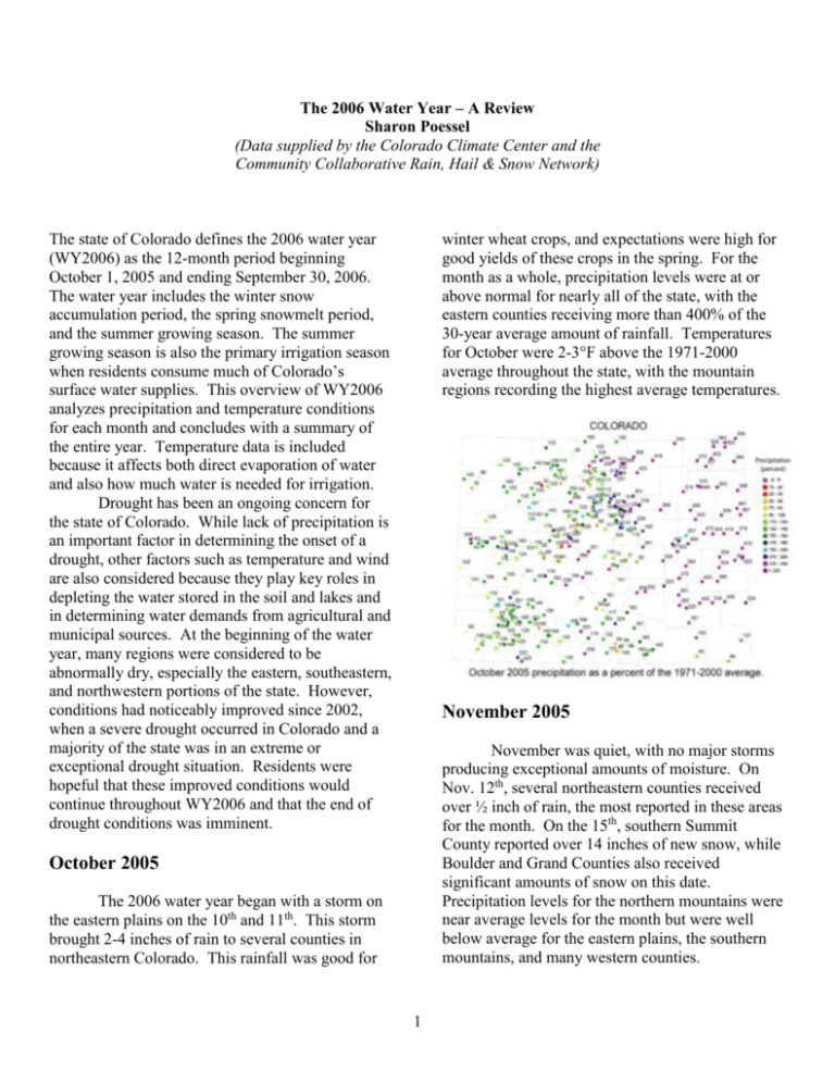
The 2006 Water Year – A Review Sharon Poessel (Data supplied by the Colorado Climate Center and the Community Collaborative Rain, Hail & Snow Network) The state of Colorado defines the 2006 water year (WY2006) as the 12-month period beginning October 1, 2005 and ending September 30, 2006. The water year includes the winter snow accumulation period, the spring snowmelt period, and the summer growing season. The summer growing season is also the primary irrigation season when residents consume much of Colorado’s surface water supplies. This overview of WY2006 analyzes precipitation and temperature conditions for each month and concludes with a summary of the entire year. Temperature data is included because it affects both direct evaporation of water and also how much water is needed for irrigation. Drought has been an ongoing concern for the state of Colorado. While lack of precipitation is an important factor in determining the onset of a drought, other factors such as temperature and wind are also considered because they play key roles in depleting the water stored in the soil and lakes and in determining water demands from agricultural and municipal sources. At the beginning of the water year, many regions were considered to be abnormally dry, especially the eastern, southeastern, and northwestern portions of the state. However, conditions had noticeably improved since 2002, when a severe drought occurred in Colorado and a majority of the state was in an extreme or exceptional drought situation. Residents were hopeful that these improved conditions would continue throughout WY2006 and that the end of drought conditions was imminent. winter wheat crops, and expectations were high for good yields of these crops in the spring. For the month as a whole, precipitation levels were at or above normal for nearly all of the state, with the eastern counties receiving more than 400% of the 30-year average amount of rainfall. Temperatures for October were 2-3°F above the 1971-2000 average throughout the state, with the mountain regions recording the highest average temperatures. November 2005 November was quiet, with no major storms producing exceptional amounts of moisture. On Nov. 12th, several northeastern counties received over ½ inch of rain, the most reported in these areas for the month. On the 15th, southern Summit County reported over 14 inches of new snow, while Boulder and Grand Counties also received significant amounts of snow on this date. Precipitation levels for the northern mountains were near average levels for the month but were well below average for the eastern plains, the southern mountains, and many western counties. October 2005 The 2006 water year began with a storm on the eastern plains on the 10th and 11th. This storm brought 2-4 inches of rain to several counties in northeastern Colorado. This rainfall was good for 1 Temperatures were well above normal for the month, ranging from 3°F higher than average for the western part of the state to 5-6°F above average for eastern Colorado. were very dry, including the Front Range urban corridor. Due to the cold wave, temperatures for the month ended up slightly below the long-term average for the mountains and western valleys. Gunnison had the lowest temperatures and ended the month more than 8°F below average, while Walden was about 4°F below average. On the other hand, the eastern plains and foothills were just above average for the month, with Ruxton Park showing the highest temperatures at almost 8.5°F above normal. December 2005 In December Colorado experienced its first severe cold wave of the season which affected the entire state. This storm occurred on Dec. 6-8th, with temperatures dropping below -10°F in northeastern Colorado and to the -40s in the mountains near Gunnison. This drop in the mountains was unusual since temperatures are usually coldest in the valleys of the high mountains rather than on the slopes of the mountains. The extreme cold resulted in high natural gas bills for many residents, which led to fears of high utility bills throughout the winter. On Dec. 3rd, Crested Butte, which usually reports the most snow in Colorado each winter, received up to 16 ½ inches of new snow. For the month as a whole, precipitation lagged behind the 30-year average for parts of the state and was ahead of the average for others. One small patch of southern Summit County and another in southeastern Grand County were above average at approximately 200%, and Steamboat Springs was over 150%. Other mountainous areas on the Western Slope were slightly above average, while most of the eastern and western counties of the state January 2006 January was unseasonably warm and dry for much of Colorado. The warm weather eased fears of high winter utility bills for residents. Precipitation levels were at or below normal for most of the state, including in the mountains. Most northeastern counties reported well below 50% of their average precipitation. Temperatures climbed this month, with all regions of the state reporting higher than average numbers. The eastern plains had the highest average temperatures, with Akron, Burlington, and Holyoke all ending the month more than 10°F above average. One exception to the warm, dry weather was a snowstorm that occurred in the Arkansas Valley on Jan. 20th. The area received 13-15 inches of snow from this storm, which would turn out to be 2 the largest amount of snow for the Valley all year. This moisture contributed to above average precipitation levels for the month for this area. Additionally, temperatures were very cold for a few days after this storm, with Rocky Ford reporting -3°F. However, this cold spell did little to decrease the average monthly temperature for this region, as Rocky Ford still ended the month 8°F above the long-term average. certain areas in the northern and central mountains, and one patch in the southern mountains, were near the average. Rainfall in Fort Collins, Greeley, and Boulder was also near average, while the eastern plains other than Logan County received no significant moisture at all during the month. March 2006 Cool temperatures continued in March. Precipitation in the northern and central mountains was near or above average for the month. The southern mountains received their first significant snow in March, with the heaviest periods Mar. 8-13th and Mar. 19-20th. For this month only, the wettest area in Colorado was in the southern mountains, with northern Mineral County reporting precipitation of almost 350% above average. The northwestern counties were also above average, while most of the eastern plains were below normal. Temperatures were right at average levels for every region of the state except the western valleys, where they were slightly below normal. The reading for this area was mostly due to Cedaredge, which was more than 3°F below the average for the month. February 2006 After a warm January, February was much cooler. The state experienced its second extreme cold wave on Feb. 16-20th. Temperatures fell to -10°F or less in eastern Colorado, including the Front Range and east to the state border. Haxtun received 1 ½ inches of snow on the 16th. This cold period, however, did not include western Colorado. Even with the cooler weather, average temperatures for the month were only slightly below average for the entire state and were highly variable. Some regions of eastern Colorado were colder than normal, with Canon City and New Raymer reporting temperatures approximately 5°F below average. While many areas in the western half of the state were colder than average, others such as Rangely and Durango ended the month 3-4°F above normal. Despite the cold wave, precipitation levels were below normal for much of the state. Only 3 snowy winter. These heavy snow conditions stopped at the Continental Divide and only included the upper elevations of the Western Slope. However, moisture levels were below average for most of the southern mountains and along the Front Range urban corridor. April 2006 Temperatures were significantly warmer in April. All regions of the state reported temperatures that were 3-5°F higher than the long-term averages. This month was the beginning of the warm, dry spring that characterized the water year. Moisture levels were low throughout the state. The highest amount of precipitation occurred on the 29th, with Westcliffe in western Custer County recording over 11 inches of snow. However, this amount was not enough to push moisture levels above average for this area. For the month as a whole, only a small portion of the central mountains reached near average precipitation levels, and most areas west of the Continental Divide were below average. The eastern plains, including the Fort Collins/Greeley area, received little measurable precipitation. These conditions led to an early melt out of snow in the mountains and more of a reduction in the amount of water streamflow than was expected. These circumstances raised concerns over drought in Colorado. April marks the end of the mountain snow accumulation season. For the entire winter season, October through April, precipitation totals were slightly above average for the plains of northeastern Colorado, most of which was due to the October storm. They were also above average in the northern and central mountains, which includes Gunnison north to the Wyoming border, due to the 4 average precipitation levels. Many areas reported moisture of less than 10% of average, including Rifle, Meeker, and Fort Collins. Temperatures were again 3-4°F above average throughout the state, with the foothills areas more than 4.5°F above normal. Aspen recorded high temperatures in June that were almost 10°F above its long-term average. Spring crops, including corn, sorghum, and sunflowers, require a large amount of irrigation just to get them started when planted. Since many crops did not receive enough moisture during the spring, their yields were below average which resulted in low profits. Winter wheat crops, which had looked promising due to the October rains, also produced poor yields and low profits due to the dry spring. With the early snowmelt and reduction in streamflow, by the end of June drought was a serious concern in Colorado. The 2006 Growing Season The 2006 growing season is defined as approximately May through September. This period includes the season for spring and summer crops, which are significantly affected by moisture levels. This season began with warm, dry weather which raised concerns over crop yields. Here is a month-by-month account. May 2006 Warm temperatures and dry conditions continued through May. Larimer County received 1-2 inches of snow on May 4th, with approximately ½ inch of water equivalent. Rain fell on the eastern plains on May 23rd, with places in Lincoln and Kit Carson counties reporting between 1-1 ¾ inches. The remainder of the month was very dry, with most of the state below the 30-year average for the month as a whole. Temperatures ended up between 3°F and 4°F above average over all areas of Colorado. July 2006 The month of July brought welcome relief to Colorado. The month began with significant amounts of precipitation. July 2-11th became the turning point from hot, dry conditions to humid, showery conditions. July 9th was the wettest day of the water year, with over 3 inches of rain reported in Pueblo and 2/3 of an inch on average for the entire state. The majority of the state was well above average precipitation levels, with places such as Canon City and Alamosa over 300% above June 2006 June was a continuation of the warm, dry spring. The largest amount of rainfall occurred on June 25th in Boulder and Jefferson counties, averaging close to 1 inch of precipitation. Extremely dry conditions prevailed throughout the month, with the majority of the state well below 5 County experiencing the most moisture on the 26th with 1-2 ¼ inches of rain and Pueblo reporting over 2 inches on the 27th. For the month as a whole, precipitation was variable throughout the state. Parts of the eastern plains were below average while others were more than 200% above average, most of these areas in southeastern Colorado. Most of western Colorado and throughout the mountains was above average, with Salida reporting over 300% above normal. Despite the rains of the 26th, northeastern Larimer County was below 50% of average precipitation. Temperatures were variable throughout Colorado in August, with most regions fluctuating around the long-term average. The eastern half of the state, as well as the mountains, was slightly above the average, while the western valleys were just below the average. Several western cities reported below normal temperatures which contributed to this lower overall average. normal. However, extreme northeastern and northwestern areas in Colorado were well below average, such as Crook in Logan County with only 27% of normal. Temperatures for July remained well above average but were slightly cooler overall. The mountains were the warmest with temperatures 3°F above average. Taylor Park recorded high temperatures of over 5°F above normal. All other areas of the state were less than 3°F above average, with the eastern plains only 2.3°F above normal. The July rains eased fears over drought somewhat. Water use decreased in July so available water resources were able to be maintained throughout the rest of the summer. Summer dryland crops fared better due to the July moisture. Results were locally variable but overall the state produced good summer crops. By and large, July was the month that turned around a potentially disastrous situation for Colorado that otherwise could have resulted in a reduction in food and water supplies and low profits for agricultural communities. September 2006 September temperatures were cooler, a relief from the warmer than average summer. The mountains experienced their first significant snowfall of the season on Sept. 21-23rd, with most of this precipitation occurring in the central mountains in Gunnison, Summit, and Park Counties. Rain fell on the eastern plains on the 21st, with as much as 2 inches in Las Animas. Sept. 9th August 2006 The rains continued in August, though they were not as heavy as in July. Average precipitation was notable on the 14th, 19th, 26th, and 27th. On Aug. 26-27th, rain fell on the majority of the state, with Larimer County and some parts of Elbert 6 also brought up to 2 inches of rain to several counties in northeastern Colorado. This amount of rainfall caused precipitation levels for the month of September to be 200-300% above average for most of the eastern plains. The only exceptions were extreme southeastern Colorado in Baca County and in the northern portion of the Front Range, which were well below average for the month. Most of the mountain areas and western Colorado were above the average precipitation levels. Temperatures for the month as a whole were significantly below the 1971-2000 average for all areas of Colorado. The mountains were more than 3°F below average, the foothills and western valleys were more than 3.5°F below average, and the eastern plains were the coolest at over 4.5°F below normal. Trinidad had the coolest average reading in the state with 6.8°F below normal. 7 winter with temperatures from -20° to -30°F. However, this year the Valley did not receive much snow and the coldest temperature was only a few degrees below zero. This reading was about the same temperature as the coldest temperature in southeastern Colorado, which is unusual since the San Luis Valley is usually quite colder than southeastern Colorado. This year the low temperatures of the two areas were comparable. 2006 Water Year Summary Highlights of the 2006 water year included a soaking October storm over eastern Colorado, a windy dry winter over the foothills and eastern plains, frequent midwinter snows in the northern mountains, a very warm and dry spring, a wet summer over much of southern Colorado, and a chilly ending to another warm year. The precipitation for WY2006 as a percent of the 30-year average ended below average on the eastern plains and parts of western Colorado, and near or slightly above average throughout the mountains. Salida reported the highest amount of precipitation with 153% of normal, and Fort Collins was one of the driest areas with only 57% of normal. Temperature Departures for Water Year 2006 10.0 Temperature Departure (deg F) 8.0 6.0 4.0 2.0 0.0 -2.0 -4.0 -6.0 Oct Nov Dec Jan Eastern Plains Feb Mar Foothills Apr May Mountains Jun Jul Aug Sep Western Valleys The winter winds were another noteworthy aspect of WY2006. The heavy snows in the mountains were the result of a strong wind pattern that brought high-speed air from the Pacific Northwest through the jet stream, resulting in frequent, persistent strong winds from late fall to early spring. This winter was one of the windiest on record since the 1980s. This northwesterly wind blew over the northern and central mountains, correlating with the heavy accumulation of snow in these areas. This combination also contributed to the downwind side of the mountains being dry and windy. The abundant snow in the northern and central mountains led to good publicity for skiing and outdoor recreation areas located in this region. These resorts enjoyed a good year economically, but those in the southern mountains did not fare as well. However, the majority of Colorado’s ski areas are in the northern and central mountains. A good combination for outdoor recreation is snowfall in the mountains but not on the plains, since traveling to the ski resorts is much easier with less snow on For the year as a whole, temperatures were on the warm side (see temperature departure graph to the right). November, January, and April were exceptionally warm statewide while several other months were also warmer than usual. September was the only month that was significantly cooler than average, bringing some relief to the end of an especially warm year. Other than the two cold waves that hit Colorado in December and February, temperatures in winter were not too severe and, in many areas, were warmer than average for the 13th consecutive winter. One interesting event occurred in the San Luis Valley. This area is usually very cold in 8 the roads. This combination provides positive economic returns for both the recreation and transportation industries. The primary feature of the 2006 water year was a dry, warm spring with no heavy, widespread storms. These conditions once again raised fears of drought in Colorado, and with the early spring snowmelt and reduced streamflows, water management agencies were concerned about having enough water supplies to meet the needs of agricultural and municipal users. A reprieve came in July with increased precipitation, which continued through the end of the water year. The May – September growing season was hit hard early on with dry, hot weather. Winter wheat and spring crops did not fare well due to the decreased moisture. However, summer crops produced better results after the July rains arrived. Overall, the summer was warmer than average, but early summer was more unusual than later summer, due to the cooling temperatures brought by the late summer rains. The dry winter and spring also resulted in poor forage for cattle on the plains and in southern Colorado. Ranchers were forced to sell their cattle earlier than expected, which led to reduced profits. Selling prices of cattle are based on weight, and the animals sold were lighter than they would have been if they were sold in the fall. Market prices for cattle have recently increased; consequently, many ranchers are interested in increasing their herd sizes. However, they have been unable to do so since range conditions have not improved much since the drought of 2002. Rangelands did green up after the July rains, leading to improved forage for the remaining cattle. However, overall conditions for ranchers were bleak in spring and early summer. One situation worthy of mention is the risk of wildfires. A dry, windy spring season creates prime conditions for forest fires. State and local officials were more concerned about fire risk along the Front Range, due to the windy conditions, than in the mountains. Some fires did occur in midwinter/early spring; these were mostly grass fires on the plains in late winter. The concern in spring was forest fires, especially in western Larimer County, western Boulder County, and west of Denver, Colorado Springs, and Pueblo, due to the extremely dry conditions along the Front Range. Some early fires did arise; however, May and June, which were warm, did not have strong winds and had little lightning which are both necessary to spread wildfires. Also, many counties imposed fire bans, and residents were very careful about mitigating fire hazards. As a result, Colorado had very few major forest fires in the spring and summer fire season. In the western United States overall, 2006 was the worst fire season in terms of acres burned in the modern era, i.e., since 1960. Hence, Coloradoans were able to escape a potentially brutal fire season, due to the efforts of state and local officials and residents. During the dry spring and early snowmelt, Colorado residents became concerned about having sufficient water supplies to meet the needs of municipal and agricultural users. Most of Colorado’s reservoirs are in the northern and central mountains, which received the most snow this winter. These reservoirs include Lake Dillon, which serves the Denver metropolitan area, and Lake Granby, which is the cornerstone of the Colorado-Big Thompson Project which serves several communities in northern and northeastern Colorado. Since there was plentiful snow, there was good runoff in these reservoirs to serve the people of Colorado, and they delivered a large amount of water to both urban users and agricultural users. The reservoirs in the southern mountains did not fare as well. These areas had less runoff than expected, but the water generated was still sufficient for users in that region. Also, the summer rains, which usually do not make a significant contribution to reservoir levels, reduced the need for irrigation and may have been a factor in these levels this year. Overall, reservoirs were near their average levels at the end of WY2006 (see graph on following page). While heavy winter snows in the mountains and late summer rains throughout the state contributed greatly to moisture levels, the dry, windy spring led to average or slightly below average precipitation in most of the state. At the 9 end of the 2006 water year, the state as a whole was in slightly better drought condition than at the beginning of the year, with overall precipitation over 90% of average levels. The exception was northeastern Colorado, which ended the year in a moderate to severe drought condition. Drought has been and continues to be a serious issue in the state of Colorado. In a paper on the 2002 drought in Colorado published in Pure and Applied Geophysics in 2005, Roger A. Pielke, Sr. states that Colorado society is now more vulnerable to short-term drought than in the past, due to precipitation deficits, hot temperatures, evaporation losses, and higher than average municipal and irrigation demands. Pielke, who is a Senior Research Scientist in the Department of Atmospheric Science at Colorado State University in Fort Collins, Colorado, asserts that these factors severely impact many economic sectors in Colorado. Even though drought conditions appear to be improving in the state, water management agencies in Colorado will nevertheless need to continue to respond to these issues by taking actions to mitigate the negative effects of drought and implement water conservation strategies. Colorado Statewide Reservoir Levels on October 1st for Years 1997- 2005 and Sept 1, 2006 140 Percent of Average 120 100 80 60 40 20 10 6 20 0 05 Se p 1. 1. 20 04 Oc t 1. 20 03 Oc t 1. 20 02 Oc t 1. 20 01 Oc t 1. 20 00 Oc t 1. 20 99 Oc t Oc t 1. 19 98 19 1. Oc t Oc t 1. 19 97 0
