Science Ch 5 webnotes
advertisement
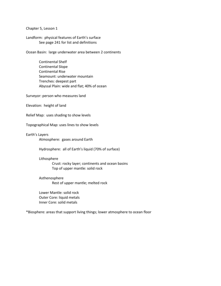
Chapter 5, Lesson 1 Landform: physical features of Earth’s surface See page 241 for list and definitions Ocean Basin: large underwater area between 2 continents Continental Shelf Continental Slope Continental Rise Seamount: underwater mountain Trenches: deepest part Abyssal Plain: wide and flat; 40% of ocean Surveyor: person who measures land Elevation: height of land Relief Map: uses shading to show levels Topographical Map: uses lines to show levels Earth’s Layers Atmosphere: gases around Earth Hydrosphere: all of Earth’s liquid (70% of surface) Lithosphere Crust: rocky layer; continents and ocean basins Top of upper mantle: solid rock Asthenosphere Rest of upper mantle; melted rock Lower Mantle: solid rock Outer Core: liquid metals Inner Core: solid metals *Biosphere: areas that support living things; lower atmosphere to ocean floor Chapter 5, Lesson 2 Geologist: studies rocks to find out about Earth’s history and structure Theory of Continental Drift: continents were once together (Pangaea) and have drifted apart Evidence includes: mountains between South America and Africa match Fossils Coastlines Plate Tectonics: model to explain how ocean floor spreads and continents move Compression: squeezing together; creates folded mountains (Himalayas) Shear: a result of one plate rubbing against another causing twists or tears in crust Fault: a deep crack in crust; if one moves up and other down result is a fault block mountain (Sierra Nevada) Chapter 5, Lesson 3 Volcano: opening in Earth’s crust; most found where plates meet (usually where 1 plate is pushed under another…diving plate melts in the heat of the mantle and forms magma) Ring of Fire: circle of volcanoes around the Pacific Ocean Lava: magma which reaches the Earth’s surface Crater: depression formed around a vent Caldera: hole formed when volcano collapses on itself Dike: formed when magma hardens in vertical cracks Sill: forms when magma hardens in horizontal cracks Laccolith: magma pushed into sills; dome shape that raises rock layers above it Batholith: largest underground magma formation; form hills Active: erupting or recently erupted Dormant: quiet for a time Extinct: no longer erupts Shield Volcano: built by thinner fluid lava that spreads over large area; broad base, sloping sides Cinder-cone Volcano: thick lava thrown high into the air and falls as chunks or cinders; Cone shaped with narrow base and steep sides Composite Volcano: built by layers of ash and cinders sandwiched between hardened lava; Look the same on both sides. Hawaiian Islands are a line of volcanic mountains. Formed over a hot spot; when they grew tall enough they became islands Hot spot: stationary pool of magma Island Arc: where two ocean plates meet and one is pushed under another (Aleutian Islands) Chapter 5, Lesson 4 Earthquake: sudden movement of Earth’s crust usually along a fault line at the boundary of tectonic plates Focus: place where slipping begins Epicenter: point on Earth’s surface directly above the focus Seismometer: instrument that detects and measures waves produced by earthquakes Primary (P) waves: fastest; pass through solid and liquid layers; move back and forth Secondary(S) waves: half as fast; only through solid layers; move up and down Surface (L) waves: slowest like ripples on a pond; on Earth’s surface; cause most damage Magnitude: amount of energy released by an earthquake Richter Scale: used to measure magnitude (each whole # indicates 30 x more energy) Mercalli Scale: measures what people felt and what happened to objects (more real life) Aftershocks: earthquakes with less magnitude Tsunami: huge wave caused by earthquake in the ocean; generally 6.5 or higher Buildings now have rubber and steel between foundation and building to allow the building to sway without causing damage. If you have warning furniture should be secured to walls. Scientists try to predict quakes by looking at changes in angle of the ground. They are very difficult to predict. Chapter 5, Lesson 5 Weathering: the process by which rocks are broken down Physical Weathering Temperature changes Pushing and pulling Water freezing and expanding cracks Plants growing and increasing cracks Gravity Wind Chemical Weathering Groundwater Acid Rain: formed by gases from factories combine with rain Erosion: weathered rock is moved from one place to another Gravity: mudslides, landslides Glaciers: large mass of flowing ice; as glacier moves it carries away bits of rock; Cirque: steep bowl shaped hollow at edge of glacier Deposition: eroded materials are dropped off in another place Rivers erode rock and soil and wash it downstream. Meanders: slow moving curved rivers Delta: fan shaped area at mouth of river Sandbars: created by waves carrying sand offshore Barrier islands: sandbar that stretches miles and protects shoreline Dunes: formed by wind at the back of beach; protect area farther inland Fences and plants can be added to protect dunes Floodplain: place that is easily flooded when river rises and sediment is deposited here Wetlands soak up water and reduce chance of flooding People can also control some erosion by building dams, levees (walls), and canals.
