field guide as
advertisement
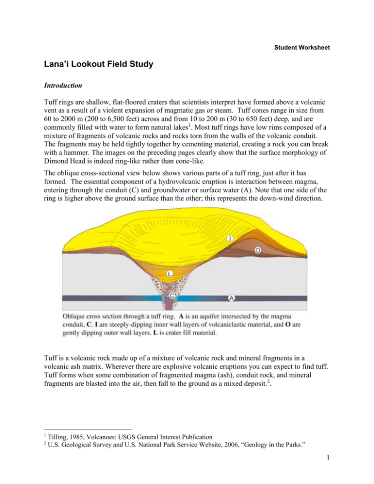
Student Worksheet Lana’i Lookout Field Study Introduction Tuff rings are shallow, flat-floored craters that scientists interpret have formed above a volcanic vent as a result of a violent expansion of magmatic gas or steam. Tuff cones range in size from 60 to 2000 m (200 to 6,500 feet) across and from 10 to 200 m (30 to 650 feet) deep, and are commonly filled with water to form natural lakes1. Most tuff rings have low rims composed of a mixture of fragments of volcanic rocks and rocks torn from the walls of the volcanic conduit. The fragments may be held tightly together by cementing material, creating a rock you can break with a hammer. The images on the preceding pages clearly show that the surface morphology of Dimond Head is indeed ring-like rather than cone-like. The oblique cross-sectional view below shows various parts of a tuff ring, just after it has formed. The essential component of a hydrovolcanic eruption is interaction between magma, entering through the conduit (C) and groundwater or surface water (A). Note that one side of the ring is higher above the ground surface than the other; this represents the down-wind direction. Tuff is a volcanic rock made up of a mixture of volcanic rock and mineral fragments in a volcanic ash matrix. Wherever there are explosive volcanic eruptions you can expect to find tuff. Tuff forms when some combination of fragmented magma (ash), conduit rock, and mineral fragments are blasted into the air, then fall to the ground as a mixed deposit.2. 1 2 Tilling, 1985, Volcanoes: USGS General Interest Publication U.S. Geological Survey and U.S. National Park Service Website, 2006, “Geology in the Parks.” 1 Working with Maps The map below is includes manmade features such as roads, but also shows contour lines indicating topographic relief. Two volcanic features are labeled: Koko Crater and Rifle Range crater. 1. Mark the highest point shown on the map with an “x”. 2. Which edifice, Koko Crater or Rifle Range crater, has steeper outer slopes? How can you tell? 3. Estimate the distance between the centers of these craters (arrow tip to arrow tip), in meters. Additional info. The tall tuff cone of Koko Crater (1208ft. 368m) tuff cone represents a contrast in eruption style to the adjacent, and much lower-standing, Rifle Range tuff ring. It may not be obvious at first, but the Rifle Range was a more intense eruptive event! (Note: eruption intensity is a measure of mass eruption rate, kg s-1, and is distinct from the total erupted mass, kg.) Weak eruptions produce beds that stack to form cones; strong or powerful eruptions produce “sheet-like” fall deposits. In the more intense Rifle Range event, material was distributed away from the vent, yielding thinner beds that are more widely dispersed. 2 The pair of images below shows the nested tuff rings composing Koko Head and enclosing Hanauma Bay. 4. What information does the satellite image provide that the terrain map lacks? 5. What information does the terrain map provide that the satellite image lacks? 6. Draw each crater rim on the terrain map. Hint: it is not possible to see the rings in their entirety; consider each circular crater rim segment to be a separate ring. How many tuff rings (or cones) are present in this complex? Additional info. Although the rims of these tuff rings may never have been completely closed, it is probable that about 10,000 years ago, coincident with a post-glacial rise in sea level, the outer wall of Hanauma Bay tuff ring was breached, permitting inundation and growth of coral in the bay. The oldest known coral is about 7,000 years old. 3 At the Outcrop Even though this place is called Lāna‘i Lookout, It is usually a lot easier to see Moloka‘i from here. Be very careful of slippery slopes and of large waves! Step over the guardrail and gather near the top of the slope to examine the outcrop. 7. How many layers are there? very few some lots super lots 8. Consider the photo and caption below. What does the number of layers at this site tell you about the eruption (for example, was there a constant fountain or multiple explosions)? 9. Describe the layers you see here. How thick are they? How can you distinguish one layer from another? 4 Large clasts are too massive to be transported in an eruption plume, which rises convectively and then travels laterally from the vent. These blocks follow parabolic flight paths, like footballs thrown by very strong quarterbacks. These so-called bombs impact the ground with considerable force. If the ground surface is soft, the bombs bury themselves in their craters. The crater shape indicates the direction the bomb came from. 10. Find and sketch two bombs and the surrounding layers. Are the layers below the bombs disturbed the same way the overlying layers are? Is the sag symmetrical below the bomb? What does this tell you about the direction from which the bomb fell? Carefully make your way to the bottom of the outcrop, near the shore. Be wary of loose gravels, they can roll out from under your feet and cause a fall. Walk into the shady cave-like area where you can see two large white blobs. 11. Did these big chunks of coral grow here or were they blown out and dumped here by the eruptions? How would you tell? 5
