Application for Community Risk Assessment
advertisement
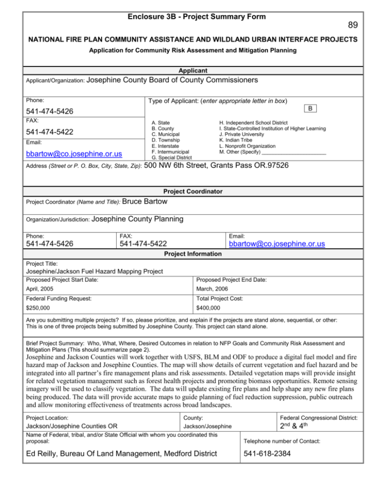
Enclosure 3B - Project Summary Form 89 NATIONAL FIRE PLAN COMMUNITY ASSISTANCE AND WILDLAND URBAN INTERFACE PROJECTS Application for Community Risk Assessment and Mitigation Planning Applicant Applicant/Organization: Josephine County Board of County Commissioners Phone: Type of Applicant: (enter appropriate letter in box) B 541-474-5426 FAX: A. State B. County C. Municipal D. Township E. Interstate F. Intermunicipal G. Special District 541-474-5422 Email: bbartow@co.josephine.or.us Address (Street or P. O. Box, City, State, Zip): H. Independent School District I. State-Controlled Institution of Higher Learning J. Private University K. Indian Tribe L. Nonprofit Organization M. Other (Specify) _______________________ 500 NW 6th Street, Grants Pass OR.97526 Project Coordinator Project Coordinator (Name and Title): Bruce Organization/Jurisdiction: Josephine Bartow County Planning Phone: FAX: Email: 541-474-5426 541-474-5422 bbartow@co.josephine.or.us Project Information Project Title: Josephine/Jackson Fuel Hazard Mapping Project Proposed Project Start Date: Proposed Project End Date: April, 2005 March, 2006 Federal Funding Request: Total Project Cost: $250,000 $400,000 Are you submitting multiple projects? If so, please prioritize, and explain if the projects are stand alone, sequential, or other: This is one of three projects being submitted by Josephine County. This project can stand alone. Brief Project Summary: Who, What, Where, Desired Outcomes in relation to NFP Goals and Community Risk Assessment and Mitigation Plans (This should summarize page 2). Josephine and Jackson Counties will work together with USFS, BLM and ODF to produce a digital fuel model and fire hazard map of Jackson and Josephine Counties. The map will show details of current vegetation and fuel hazard and be integrated into all partner’s fire management plans and risk assessments. Detailed vegetation maps will provide insight for related vegetation management such as forest health projects and promoting biomass opportunities. Remote sensing imagery will be used to classify vegetation. The data will update existing fire plans and help shape any new fire plans being produced. The data will provide accurate maps to guide planning of fuel reduction suppression, public outreach and allow monitoring effectiveness of treatments across broad landscapes. Project Location: County: Federal Congressional District: Documented methodology applicable to large areas of the western united states. Jackson/Josephine Jackson/Josephine Counties OR 2nd & 4th Name of Federal, tribal, and/or State Official with whom you coordinated this proposal: Telephone number of Contact: Ed Reilly, Bureau Of Land Management, Medford District 541-618-2384 Enclosure 3B (Page 1 of 3) - Project Narrative Description Applications for funding must include a narrative response that describes the proposal. Please do not submit responses longer than one page, single space, 12-pitch font. Describe project including, but not limited to: change fire behavior WHO are your collaborators - are they current or potential collaborators? Address these through fuels reduction describe the relationship of this plan’s desired outcome to NFP Goals items as increase community and to any existing community fire protection plan. applicable: education and awareness project time frames and matching or contributed funds enhance fire protection tools and/or skills needed to complete project capability specific project location, geographic extent, and fire risk assessment desired outcome methodology For this project, explain the level of cooperation, coordination or strategic planning, through a “Local Coordination Group.” If you haven’t worked with a local coordination group, why not? This project’s location is in Jackson and Josephine Counties, Oregon and includes all lands within the two county area of approximately 2,850,000 acres. Current collaborators include Oregon Department of Forestry; Jackson County, Oregon; Josephine County, Oregon; US Forest Service, Rogue River - Siskiyou National Forests; Bureau of Land Management, Medford District; and Rogue Valley Fire Chiefs Association. This project will provide continuous vegetation cover and fuel hazard mapping covering both Josephine & Jackson Counties (2,850,000 acres). Maps and data will use agreed upon data standards that allow all partners to accomplish hazard and risk assessments using the same methodology. Accurate vegetation and fuel maps are the essential GIS layer needed to produce hazard assessments. All cooperators are actively pursuing the completion of fire hazard & fire management assessments. Current available vegetation and hazard data is not of sufficient detail and in some areas is over ten or even fifteen years old. Acquiring new data will enhance all partners’ abilities to complete and update fire plans across the two county area. It will allow strategic planning and prioritization of on the ground fuel reduction efforts as well as monitoring the effectiveness of treatments. Strategic landscape level treatments as well as individual homeowner prevention measures are the key to successful large scale changes in fire behavior. Much of the knowledge, tools and skills to complete this effort are present among the cooperating agencies and groups. Remote sensing image processing will be required to be contracted. After award of grant in early fiscal year 2005, a Request For Proposal will be let for a remote sensing contractor. Existing contractors with proven methodologies and performance records for this work are available. The cooperators have already met and agreed on basic data standards. Continued coordination between the cooperators will take place as the project progresses. Fieldwork would be conducted during the summer of 2005. Image processing would be done after field season in the fall of 2005. Final maps and data sets would be delivered to all cooperators approximately one year from receipt of funds and the start of this effort. The hazard mapping and risk assessment methodology will use proven remote sensing vegetation classification methods. Extensive ground samples will be performed to stratify fuel loadings and plant communities. The maps produced will be used in outreach and public education efforts. Having up to date and reliable data for discussion with public and cooperators is a key to developing trust and effective short and long term fuel reduction suppression strategies. This project is being developed with methods that will allow for low-cost updates approximately every five years. The members of the local Jackson / Josephine County wildfire coordination group support this effort and letters of support are on file. The Fuels Mapping project allows all land management agencies within the two counties, to plan and discuss treatments and activities using the same maps and standards. Using the same maps and methodologies enhances community trust and support and can greatly improve both public and agency communication as we continue to develop a combined strategy for fuels reduction and suppression. Enclosure 3B (Page 2 of 3) - Project Evaluation Criteria Applications for funding, must include narrative responses that address the following four criteria. Be sure you address every one briefly, yet thoroughly. Limit your responses to the area provided. 1. Planning for Action (40 points) A. Describe your desired plan outcome and how the outcome will be measured. B. How will the plan address : Fire behavior changes through fuels reduction Community education and awareness Enhanced suppression capability C. How will the completed plan be implemented, and by whom? OR How does this plan enhance or complete previous fire planning by the community? D. How will the plan address landowner responsibility for implementation of this plan? E. Describe your ability to complete project in one year of receipt of funds Response: A: A digital fuel model and fire hazard map of both Jackson and Josephine counties used by the Forest Service, BLM, ODF and the two counties to plan and monitor fuels reduction and fire suppression seamlessly over the two county area. B: The Fuel Hazard Maps will be used to identify the areas with the highest fuel hazard. The highest risk and hazard areas will be targeted for fuels reduction work and public outreach. Existing fire plans will be updated or completed based on the up to date accurate maps. Landscape level strategic planning guided by fuel hazard maps is key to making a significant change in fire behavior. The results of this fuels mapping project will be made available to all cooperating agencies. Fuel hazard maps will be the foundation for public discussion and outreach efforts. Fire modeling can be done for local area residents as well as the agencies involved with fire suppression efforts. C: The maps produced will update existing agency fire management plans as well as initial attack strategies for FS, BLM, ODF and rural fire departments. GIS/planning units of both Josephine and Jackson counties as well as State and Federal partners will utilize this data. Josephine County has the expertise to administer contracts and has in-house GIS professionals. In conjunction with Jackson County, the USFS, BLM and ODF partners all have a high level of expertise available. USFS and BLM cooperators have direct experience with similar mapping efforts and will provide support. D: Landowners will see how their properties affect overall strategies. High fuel areas can be targeted for strategic work. E: The Counties, State and Federal Partners all have sufficient personnel, experience and proven history of completing large scale assessments like this. 2. Enhancing Community Collaboration and Local Capacity. (30 points ) A. Describe your strategy for collaboration to develop this plan across multiple ownerships. B. Identify the interested partners and members of the community who are involved in this project, and the level of their involvement. C. How will this project enhance local community collaboration and local capacity for cooperative action? D. Describe skills or experience the community will gain through development of this plan. Response: A: County, State and Federal government partners are all currently working together and are committed to this project and will work to assure its success. They represent all land management agencies in the two county area. B: Josephine County; Jackson County; US Forest Service, Rogue River-Siskiyou National Forests; Medford District Bureau of Land Management; Oregon Department Of Forestry, Rogue Valley Fire Chiefs Association. Financial and schedule oversight will be provided by the Planning Department of Josephine County. Specialists within the counties along with BLM, USFS, ODF and local city/county Fire Departments will provide technical expertise. C: All cooperators and users of the products will employ common standards, terminology and methodology to map and plan fire hazard reduction projects. The fire hazard maps will provide a baseline for organizations in the two county area developing localized fire plans. Subsequent updates of fire hazard maps can be generated at reduced costs. The remote sensing data collected for this project, coupled with the extensive field measurements can be used for other wild land and environmental applications; forest inventory, bio mass opportunities, wildlife habitat, delineation and mapping of wetland and riparian plant communities, environmentally sensitive areas, tree mortality analysis, and more. D: Having up to date accurate maps will provide assistance with creating and updating fire plans, insight into landscape level patterns of vegetation, hazard reduction and fire suppression strategies and will greatly enhance the partner’s ability to effectively collaborate across boundaries. It will allow more effective interaction with interested publics. Enclosure 3B (Page 3 of 3) - Project Evaluation Criteria 3. Expanding Community Participation. (30 Points) A. B. C. D. E. Explain the level of cooperation, coordination and/or involvement of the Local Coordination Group. List the cooperators/members (in a broad way) of the local area coordination group. Describe your strategy for leveraging funding. Who are the partners and what is their commitment to the plan’s completion, including any existing or proposed cost-share agreements and their status. Describe the extent of local support or opposition for the project. Describe your strategy for post-plan marketing and collaboration for the successful implementation of the next steps described in the plan. To what extent will this project be offered to serve as a model for other communities in your sub-geographic area, state-wide area? Response: A: The local coordination group has been briefed on this project. They acknowledge the value it will have for integrating and strengthening the many independent fire hazard reduction projects currently in process. The Josephine County Integrated Fire Plan Wild fire Risk Assessment Committee, which includes representation from all the partners, have been working on their fire risk assessment over the past year. These preliminary efforts and existing working group relationships will provide a head start in the risk assessment over the twocounty area. B: Jackson and Josephine counties are expecting to provide up to $100,000 of Title III funds towards this project during the 2005 fiscal year. ODF, USFS and BLM will all provide paid staff time and technical expertise to assist in this effort. C: Local support is very strong for this effort. The two counties have some of the highest fuel hazard in the western states (as illustrated by the Josephine County Fire Plan Risk Assessment (2004) and the OSU study conducted by John Session in 2003). Recent large scale wildfires in the Jackson and Josephine counties have heightened awareness of fuel loading and fire suppression issues with the public, local, state and federal government. All cooperators are working on fuel hazard assessments and fire management plans and expect this work to be integral to their future operating plans for many years to come. D: These maps will become an integral part of each agencies basic data for fuel reduction and fire management planning. After completing this project, all partner agencies will be utilizing the same data and standards to define fuel hazard and risk. Common standards will allow enhanced collaboration across boundaries. The design of the project will produce methodology for producing low cost updates in the future. Effectiveness monitoring and methods for detecting changes in fuel loading and distribution over time will be available. E: This project will have direct application to fuel model classification, fire hazard mapping and risk assessment for any western US locality. Southern Oregon is quite diverse representing three major biomes, the temperate rain forest of the Pacific Northwest, the high desert plant communities of eastern Oregon and the Northern California coastal and Montane environments to the south. The methodology used here can be adapted for other regions of the western states. Enclosure 3C - Project Work Form Tasks Time Frame Responsible Party Secure Grant Prepare Request for Proposal Contract Choose Contractor Award Contract February 2005 March 2005 April 2005 May 2005 Josephine County Work with partners and contractor to finalize mapping and classification standards March-June 2005 All Cooperators Obtain remote sensed imagery Initial image processing Prep for classification Ecological masking June 2005 Josephine County Field Data Collection June-September 2005 Contractor Image classification October-December 2005 Contractor Review and refine map products November 2005 – January 2006 All cooperators and contractor Final Product delivery Digital maps All ground collected data Distribute to cooperators February – March 2006 Contractor and Josephine County Cooperators will provide technical assistance Image processing contractor Enclosure 3D Project Budget Cost Category Description Federal Agency Applicant Partner 1 Partner 2 In kind staff time In kind staff time Jackson/Josephine From ODF & from Josephine County Counties USFS / BLM Fire Chiefs Personnel Subtotal $35,000 $35,000 $15,000 $15,000 Total $50,000 Fringe Benefits Subtotal Travel Subtotal Equipment Subtotal Supplies Subtotal Contractual Subtotal $225,000 $100,000 $225,000 $100,000 Other 10% Administration costs Subtotal Total Costs $25,000 $25,000 $250,00 $100,000 Project (Program) Income1 (using deductive alternative) 1 Program income is the gross revenue generated by a grant or cooperative agreement supported activity during the life of the grant. Program income can be made by recipients from fees charged for conference or workshop attendance, from rental fees earned from renting out real property or equipment acquired with grant or cooperative agreement funds, or from the sale of commodities or items developed under the grant or cooperative agreement. The use of Program Income during the project period may require prior approval by the granting agency. $400,000


