TECTONICS, ROCK TYPES, SOIL, AND LANDFORMS
LANDFORMS
Throughout the semester, we will consider the pattern of landforms throughout the world. These are not the landforms that we typically think of when we use the term – mountains, valleys, plains, plateaus. Rather, these are the landforms depicted on pages 6 and
7 of the Goode’s World Atlas.
This map can provide important clues about topography, but it can also point towards other aspects of physical geography – predominant rock types, soil fertility, mineral resources, internal accessibility and hydropower potential.
For most of these reading handouts, there is a Study Guide/Practice Quiz. You might want to get it out and follow along as you read the questions.
Tectonic Plates
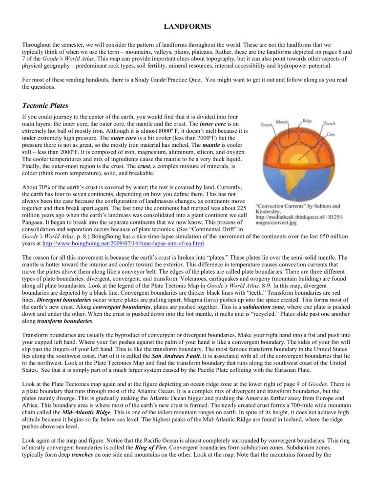
If you could journey to the center of the earth, you would find that it is divided into four main layers: the inner core, the outer core, the mantle and the crust. The inner core is an extremely hot ball of mostly iron. Although it is almost 8000º F, it doesn’t melt because it is under extremely high pressure. The outer core is a bit cooler (less than 7000ºF) but the pressure there is not as great, so the mostly iron material has melted. The mantle is cooler still – less than 2000ºF. It is composed of iron, magnesium, aluminum, silicon, and oxygen.
The cooler temperatures and mix of ingredients cause the mantle to be a very thick liquid.
Finally, the outer-most region is the crust. The crust , a complex mixture of minerals, is colder (think room temperature), solid, and breakable.
About 70% of the earth’s crust is covered by water; the rest is covered by land. Currently, the earth has four to seven continents, depending on how you define them. This has not always been the case because the configuration of landmasses changes, as continents move together and then break apart again. The last time the continents had merged was about 225 million years ago when the earth’s landmass was consolidated into a giant continent we call
Pangaea. It began to break into the separate continents that we now know. This process of consolidation and separation occurs because of plate tectonics. (See “Continental Drift” in
Goode’s World Atlas, p. 8.) BoingBoing has a nice time-lapse simulation of the movement of the continents over the last 650 million years at http://www.boingboing.net/2009/07/16/time-lapse-sim-of-ea.html
.
The reason for all this movement is because the earth’s crust is broken into “plates.” These plates lie over the semi-solid mantle. The mantle is hotter toward the interior and cooler toward the exterior. This difference in temperature causes convection currents that move the plates above them along like a conveyor belt. The edges of the plates are called plate boundaries. There are three different types of plate boundaries: divergent, convergent, and transform. Volcanoes, earthquakes and orogeny (mountain building) are found along all plate boundaries. Look at the legend of the Plate Tectonic Map in Goode’s World Atlas, 8-9. In this map, divergent boundaries are depicted by a black line. Convergent boundaries are thicker black lines with “teeth.” Transform boundaries are red lines. Divergent boundaries occur where plates are pulling apart. Magma (lava) pushes up into the space created. This forms most of the earth’s new crust. Along convergent boundaries , plates are pushed together. This is a subduction zone , where one plate is pushed down and under the other. When the crust is pushed down into the hot mantle, it melts and is “recycled.” Plates slide past one another along transform boundaries .
Transform boundaries are usually the byproduct of convergent or divergent boundaries. Make your right hand into a fist and push into your cupped left hand. Where your fist pushes against the palm of your hand is like a convergent boundary. The sides of your fist will slip past the fingers of your left hand. This is like the transform boundary. The most famous transform boundary in the United States lies along the southwest coast. Part of it is called the San Andreas Fault . It is associated with all of the convergent boundaries that lie to the northwest. Look at the Plate Tectonics Map and find the transform boundary that runs along the southwest coast of the United
States. See that it is simply part of a much larger system caused by the Pacific Plate colliding with the Eurasian Plate.
Look at the Plate Tectonics map again and at the figure depicting an ocean ridge zone at the lower right of page 9 of Goodes . There is a plate boundary that runs through most of the Atlantic Ocean. It is a complex mix of divergent and transform boundaries, but the plates mainly diverge. This is gradually making the Atlantic Ocean bigger and pushing the Americas farther away from Europe and
Africa. This boundary area is where most of the earth’s new crust is formed. The newly created crust forms a 700-mile wide mountain chain called the Mid-Atlantic Ridge . This is one of the tallest mountain ranges on earth. In spite of its height, it does not achieve high altitude because it begins so far below sea level. The highest peaks of the Mid-Atlantic Ridge are found in Iceland, where the ridge pushes above sea level.
Look again at the map and figure. Notice that the Pacific Ocean is almost completely surrounded by convergent boundaries. This ring of mostly convergent boundaries is called the Ring of Fire. Convergent boundaries form subduction zones. Subduction zones typically form deep trenches on one side and mountains on the other. Look at the map. Note that the mountains formed by the
boundary will lie along the “toothed” side of the line and the trenches will lie along the smooth side. Go to the Indian and Pacific
Oceans Floor map on pages 10 and 11. This map has lots of trenches, all of which are under water. The deepest of these is the
Mariana Trench . The bottom of the Mariana Trench is almost seven miles below sea level. On the “toothed” west side of the trench is orogeny (mountain building). On the other side of the subduction zone are the peaks of which form the Mariana archipelago. (An archipelago is a long chain of islands.)
Throughout the semester, we will consider the pattern of landforms throughout the world. These are not the landforms that we typically think of when we use the term – mountains, valleys, plains, plateaus. Rather, these are the landforms depicted on pages 6 and
7 of the Goode’s World Atlas.
This map can provide important clues about topography, but it can also point towards other aspects of physical geography – predominant rock types, soil fertility, mineral resources, internal accessibility and hydropower potential.
Rock Types
3 Major Rock Types
The many rocks that form the crust of the earth are divided into three broad categories: volcanic/igneous; sedimentary; and metamorphic. Discovery Education has a nice video ( http://uk.video.yahoo.com/watch/1444279 ) that explain how each rock type is formed and provides different examples of each.
Volcanic / Igneous Rock – most of the earth’s crust is made up primarily of cooled lava. Basically crystalline, volcanic rock can be as hard as granite or as breakable as pumice, depending on its chemical composition and how and where it cooled.
Volcanic rocks that cool on or near the earth’s surface ( basaltic ) are much more easily eroded than those that have cooled deep within the crust ( granitic ).
Sedimentary / Layered Rock – Low-lying areas of the earth’s crust gradually fill with layers of sediment from inorganic
(crushed rocks) or organic (decayed vegetation or animal matter) debris. The weight of upper layers along with heat and chemical action cause the layers to solidify. Sandstone is a sedimentary rock formed mostly of rock particles while limestone and shale are formed mostly of organic debris. This type of rock typically is easily eroded.
Metamorphic Rock – This is either igneous or sedimentary rock whose chemical structure has changed due to intense pressure, heat or chemical action. (“Meta” means change and “morph” means form.) Metamorphic rock typically is very hard and resistant to erosion. Examples are diamonds (coal – sort of), slate (shale), and marble (limestone).
Rock Type and Soil Fertility
Soil fertility is not a constant, but is highly influenced by human treatment of the soil. That said, the environment is also a major player in the quality of soil. Soil is composed of organic and inorganic material. Healthy, productive soil requires generous amounts of both. The organic component mostly decayed vegetation with some decayed animal matter. It is largely determined by climate. If the climate is too dry or too cold there may not be much plant material in the soil. The inorganic material comes from crushed rocks.
Parent rock that is easily eroded contributes the most inorganic material. In general, sedimentary rock, which is easy to erode, contributes to fertile soils. Metamorphic rock, which is resistant to erosion, produces weak soils. Volcanic / igneous rock can contribute to either fertile or infertile soils depending on if they are granitic or basaltic.
There is a lot of confusion about the relationship between soil fertility and the percentage of farmers in the population. People assume that when there is a lot of arable land, then there will be lots of farmers. This is generally not true. Large swathes of fertile soil allow mechanization. With mechanization, fewer people can produce more food, so a smaller percentage of farmers are needed to feed the population. This frees people to work at other more potentially valuable activities. So, while areas with good soil fertility may have superior agricultural production, they will typically have fewer people working in agriculture.
Rock Types and Mineable Minerals
In this class, we will discuss two basic kinds of minerals – fuel and non-fuel. Fuel minerals such as coal, petroleum, and natural gas have formed from layers of organic materials that have been caught between layers of sediment. Fuel minerals are therefore highly associated with areas dominated by sedimentary rock. Non-fuel minerals are metals and gemstones. They are highly associated with metamorphic rock. Note: we are not discussing minerals found broken up in the soil; rather, we are discussing large deposits of minerals that can be mined for profit.
Rock Type
Granitic
Igneous
Basaltic
Sedimentary
Metamorphic
Erodability
Hard
Easy
Easy
Hard
Poor
Good
Good
Poor
Soil Fertility Minerals
Mineral-poor
Mineral-poor
Fuel
Non-fuel
Landform Areas
Look at the Landforms Map on pages 6 and 7 of the Goode’s World Atlas. We shall use this map continuously throughout the semester. It is important to learn these landforms now because we will keep coming back to it in order to glean information about a region’s arability, accessibility, and resources.
In general, landforms that have been around hundreds of millions of years have more minerals than young landscapes. Although the general divisions between ancient and young landscapes do not always hold, they are often true.
Ancient Landforms
Shield areas are represented in bright yellow and gold. The yellow represents Laurasian Shield and the gold represents Gondwana
Shield. Laurasia and Gondwana were the two continents that formed when Pangaea began to break apart 225 million years ago.
Gondwana eventually split apart to form South America, Africa, Madagascar, peninsular India, Australia, and Antarctica. Laurasia split apart to form North America, Greenland, and Eurasia. Shield areas are the oldest parts of continents and are formed primarily of metamorphic rock. Note the shield areas in all of these continents – yellow to the north and gold to the south. These areas often have excellent non-fuel mineral resources. On the other hand, shields have very poor soils because metamorphic rock is so resistant to erosion. They also tend to form plateaus. Rivers in shield areas are often not navigable due to rapids and waterfalls but they often have a high potential for hydropower.
Sedimentary Cover areas are represented in green. Sedimentary areas are associated with sedimentary rock. They often form flat plains. They may have good fuel resources and may also have good soils. Rivers in sedimentary areas are typically navigable far into the interior; however they have a low potential for hydropower. Notice the water areas on the landform map. Some of the water areas are white. These represent continental shelves, or raised sea beds, and shallow lakes or seas. These areas collect sediment and sometimes they have good supplies of petroleum that are easily accessed. Some of the newly added sediment is often quite young, but in areas where the sediment is deep, the sedimentary cover areas have been accumulating over long periods.
Remnant Mountains are represented in brown. These are ancient mountains that are eroding much faster than they are rising – if they are rising at all. Like alpine areas, they also have a complex mix of rock types and therefore have a complex mix of minerals resources and soil fertility, but because of the age of the landform there is often more metamorphic and sedimentary rock. Therefore, remnant mountains typically have more minerals than alpine areas. These ancient mountains are often penetrated by rivers, though transportation can be difficult. It is easy to confuse the brown of remnant mountains with the gold of Gondwana shields.
Young Landforms
Alpine System areas are represented in purple. There are two major belts of alpine landforms. The largest circles the Pacific Ocean; the second stretches across southern Eurasia and nearby areas of Africa. Alpine systems are tectonically active areas where the land is being lifted faster than it is eroding. These areas are caused by the orogeny associated with plate boundaries, particularly convergent plate boundaries. The highest mountains in the world are found in alpine areas, but some alpine areas are relatively low-lying. All three rock types are jumbled into alpine areas. Soil quality varies because the rocks vary. Some alpine areas, particularly the archipelagos found along convergent boundaries, are basaltic rock and are therefore quite fertile. Continental alpine areas often mostly granitic rock and therefore has less fertility. Regardless, alpine areas with rugged topography will present a challenge to agriculture.
Oil and natural gas may be found in low-lying, sediment-filled areas adjacent to mountains. There may also be other minerals – particularly silver and lead – mined in highland areas. In general, however, alpine areas are young landscapes that tend to be mineral poor. River transportation in these areas is often, but not always, difficult, but there is good hydropower potential.
Rifted Shield – these are large cracks in the crust of shield areas caused by the upward thrust of magma (melted rock). Typically, these areas are dominated by volcanic rock. Mineral resources in these young landscapes are usually very poor, but soil fertility may be quite good because the volcanic rock is basaltic. Note: because this landform has the word “shield” in it, people sometimes assume that the dominant rock type is metamorphic. At left is a photo of a rifted shield area.
These are the basaltic formations that have pushed into the largest crack in the earth’s crust.
Isolated Volcanic Areas – these are holes in the earth’s surface through which magma bursts forth. Again, mineral resources in these young landscapes are usually poor but soil fertility may be quite good. Hawaii and Iceland are examples of isolated volcanic areas. As with most of these young landscapes, the topography is mountainous. River transportation is often very difficult. There is hydropower potential.
LANDFORM SUMMARY TABLE
Landform
Sedimentary
Cover
Shield
Description
Dominant
Rock Type
Sedimentary
Soil
Fertility
(If climate cooperates)
Good Plains
(river valleys and broad plains)
Plateaus with steep cliffs
Metamor- phic
Poor
Minerals
Fuel
Non-fuel
River
Navigability
YES
NO
Hydropower
Potential
NO
YES
Remnant
Mountains
Old, low, eroded mountains
Mixed Mixed Both fuel and nonfuel
NO YES
Alpine
Systems
Rifted
Shield
Young, high, growing mountains
Mixed
Volcanic mountains in large trough
Basaltic igneous
Isolated
Volcanic
Landforms
Volcanic mountains
Basaltic igneous
Mixed
Good
Good
Mineral poor
NO
Mineral poor
Mineral poor
NO
NO
YES
YES
YES
Revised January 5, 2011
