A knowledge based system as decision support for landscape
advertisement
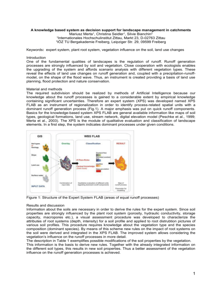
A knowledge based system as decision support for landscape management in catchments Mariusz Merta1, Christina Seidler1, Silvie Bianchin2 1Internationales Hochschulinstitut Zittau, Markt 23, D-02763 Zittau 1IÖZ TU Bergakademie Freiberg, Leipziger Str. 29, 09599 Freiberg Keywords: expert system, plant root system, vegetation influence on the soil, land use changes Introduction One of the fundamental qualities of landscapes is the regulation of runoff. Runoff generation processes are strongly influenced by soil and vegetation. Close cooperation with ecologists enables the upgrading of the system and affords scenario analysis with different vegetation types. These reveal the effects of land use changes on runoff generation and, coupled with a precipitation-runoffmodel, on the shape of the flood wave. Thus, an instrument is created providing a basis of land use planning, flood protection and nature conservation. Material and methods The required subdivision should be realized by methods of Artificial Intelligence because our knowledge about the runoff processes is gained to a considerable extent by empirical knowledge containing significant uncertainties. Therefore an expert system (XPS) was developed named XPS FLAB as an instrument of regionalization in order to identify process-related spatial units with a dominant runoff generation process (Fig.1). A major emphasis was put on quick runoff components. Basics for the knowledge-based system XPS FLAB are general available information like maps of soil types, geological formations, land use, stream network, digital elevation model (Peschke et al., 1999; Merta et al., 2003). The XPS is the module of qualitative evaluation and classification of landscape elements. In a first step, the system indicates dominant processes under given conditions. Figure 1: Structure of the Expert System FLAB (areas of equal runoff processes) Results and discussion Information about the soils are necessary in order to derive the rules for the expert system. Since soil properties are strongly influenced by the plant root system (porosity, hydraulic conductivity, storage capacity, macropores etc.), a visual assessment procedure was developed to characterize the attributes of root systems (depth, intensity) for a soil profile and applied to root distrubtion pictures of various soil profiles. This procedure requires knowledge about the vegetation type and the species composition (dominant species). By means of this scheme new rules on the impact of root systems on the soil were derived and integrated in the XPS FLAB. The improved system allows considering the vegetation’s influence on the runoff processes in more detail. The description in Table 1 exemplifies possible modifications of the soil properties by the vegetation. This information is the basis to derive new rules. Together with the already integrated information on the different soil types, this results in new soil properties. Thus a better assessment of the vegetation influence on the runoff generation processes is achieved. 1 The WBS FLAB was used in the small subcatchment Weißbach (Eastern Ore Mountains). Results show that overland flow from areas with small infiltration intensity (precipitation intensity has to be greater than infiltration rate) and interflow components predominate in this region (Fig. 2a). Table 1: Relevance of root density for soil properties Class of roots Low roots density without rough roots Medium root density few rough roots Sandy soils Cohesive soils without modification without modification slightly increasing storage capacity no change of conductivity High root density many rough roots increasing storage capacity no change of conductivity slightly increasing of conductivity no change of storage capacity growing part of macropores no change of storage capacity increasing of conductivity This subdivision agrees with hydrological measurements, detailed knowledge of the area and results of modelling with the precipitation-runoff-model WaSim-ETH. Figure (2b) demonstrates the pattern of runoff processes for the land use scenario. The whole catchment was afforested except the settlements. The overland flow disappears. Interflow seems to be the most important runoff generation process. But a general afforestation does not always reduce floods, especially when the soils are shallow and skeleton-rich. They have only a small storage capacity. The quality of the model results depends strongly on the resolution and the precision of the input data. Figure 2: Spatial distribution of runoff generation processes in the Weißbach subcatchment, resulting from the application of the Expert system FLAB. (a) Current situation, (b) land use scenario – afforestation all surfaces apart from building area. The XPS is a combination of strongly abstracted process modelling and the use of comprehensive experimental experience (expert knowledge). The connection of both offers the possibility of sophisticated analysis of spatial hydrological responses and of a catchment discretization concerning the runoff generation processes. The area-related identification of runoff components characterizes also spatial origins of water and transport paths, thus, being an important base to consider processes of matter transport. References Merta, M., Seidler, Ch., Hellie, F., Uhlenbrook, S., Tilch, N., Zillgens, B. & Kirnbauer, R. (2003): Das Wissensbasierte System FLAB als Instrument zur prozessbezogenen Raumgliederung von mesoskaligen Einzugsgebieten. In: Kleeberg, H.-B. (Hrsg.): Forum für Hydrologie und Wasserbewirtschaftung, Heft 04.03, Band 1: Klima – Wasser – Flussgebietsmanagement – im Lichte der Flut, S. 171-178 Peschke, G., Etzenberg, C., Müller, G., Töpfer, J. & Zimmermann, S. (1999): Das Wissensbasierte System FLAB – ein Instrument zur rechnergestützten Bestimmung von Landschaftseinheiten mit gleicher Abflussbildung. IHI Schriften, Heft 10, Internationales Hochschulinstitut Zittau. 2

