Flight Reports - Collins Research Group
advertisement
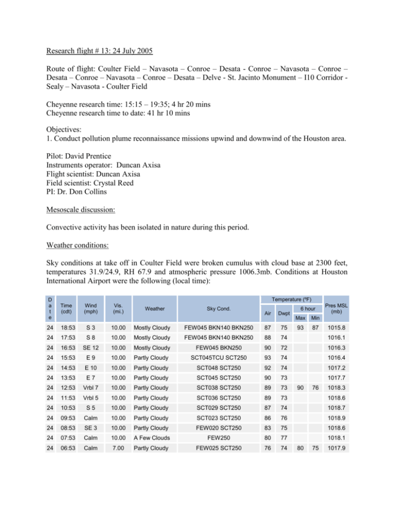
Research flight # 13: 24 July 2005 Route of flight: Coulter Field – Navasota – Conroe – Desata - Conroe – Navasota – Conroe – Desata – Conroe – Navasota – Conroe – Desata – Delve - St. Jacinto Monument – I10 Corridor Sealy – Navasota - Coulter Field Cheyenne research time: 15:15 – 19:35; 4 hr 20 mins Cheyenne research time to date: 41 hr 10 mins Objectives: 1. Conduct pollution plume reconnaissance missions upwind and downwind of the Houston area. Pilot: David Prentice Instruments operator: Duncan Axisa Flight scientist: Duncan Axisa Field scientist: Crystal Reed PI: Dr. Don Collins Mesoscale discussion: Convective activity has been isolated in nature during this period. Weather conditions: Sky conditions at take off in Coulter Field were broken cumulus with cloud base at 2300 feet, temperatures 31.9/24.9, RH 67.9 and atmospheric pressure 1006.3mb. Conditions at Houston International Airport were the following (local time): Temperature (ºF) D a t e Time (cdt) 24 18:53 S3 10.00 Mostly Cloudy 24 17:53 S8 10.00 24 16:53 SE 12 24 15:53 24 Wind (mph) Vis. (mi.) Weather Sky Cond. 6 hour Pres MSL (mb) Air Dwpt FEW045 BKN140 BKN250 87 75 Mostly Cloudy FEW045 BKN140 BKN250 88 74 1016.1 10.00 Mostly Cloudy FEW045 BKN250 90 72 1016.3 E9 10.00 Partly Cloudy SCT045TCU SCT250 93 74 1016.4 14:53 E 10 10.00 Partly Cloudy SCT048 SCT250 92 74 1017.2 24 13:53 E7 10.00 Partly Cloudy SCT045 SCT250 90 73 1017.7 24 12:53 Vrbl 7 10.00 Partly Cloudy SCT038 SCT250 89 73 24 11:53 Vrbl 5 10.00 Partly Cloudy SCT036 SCT250 89 73 1018.6 24 10:53 S5 10.00 Partly Cloudy SCT029 SCT250 87 74 1018.7 24 09:53 Calm 10.00 Partly Cloudy SCT023 SCT250 86 76 1018.9 24 08:53 SE 3 10.00 Partly Cloudy FEW020 SCT250 83 75 1018.6 24 07:53 Calm 10.00 A Few Clouds FEW250 80 77 1018.1 24 06:53 Calm 7.00 Partly Cloudy FEW025 SCT250 76 74 Max Min 93 87 90 80 76 75 1015.8 1018.3 1017.9 Flight planning: The main objective of this flight was to measure the background aerosol and CCN concentrations north and south of the Houston area under southerly surface winds. Preflight: The CCN counter was operated at a supersaturation of 0.3 during the duration of the flight. The TDMA was operated in DMA mode with the RH set at 30%. Flight report: The research aircraft departed Coulter Field at 15:29. Cloud bases were measured at 2300 feet immediately after takeoff. Tops were observed to reach altitudes of about 4000 feet with a few isolated tops reaching 5000 feet. At 15:35 the aircraft was straight and level at an altitude of 3000 feet. Winds at this level were 170 4m/s. At 15:39, the aircraft was climbed to 5000 feet by air traffic. At 15:41, the aircraft was at Navasota VOR at 5200 feet. CCN concentrations at this altitude were 400/cc. Cloud tops are below the aircraft altitude. At Conroe, clouds appear fewer and shallower in the Conroe area. Winds at this altitude are 185 at 5m/s. Coulter Field Conroe Navasota Sealy In & out of cloud Houston Below cloud base Flight track and altitude profile Below cloud base CCN counts over the duration of the flight Notes were taken for the duration of the flight: 15:50 – CCN increase to 500/cc over the Conroe area at 5200 feet. 15:53 – the aircraft descends to 3000 feet 15:55 – the aircraft is straight and level at 3000 feet. Wind at this location and altitude is 190 at 2m/s. Various cloud penetrations are conducted at this level. Clouds appear to be no more than 500 feet deep with only isolated towering cumulus. 16:10 – the aircraft turns west at Desata at 2800 feet. Wind at this location is 130 at 2m/s. 16:22 – cloud bases are about 500 feet higher at 3300 feet 8 miles east of the Conroe area. 16:28 – over the Conroe area, CCN increase to 1000/cc out of cloud along I45. Wind at this location is 140 at 5m/s. 16:40 – the aircraft is turning east at Navasota and descending to 3000 feet for CCN measurements. The aircraft descends to 2300 feet since the cloud bases are at 3000 feet. 16:53 – CCN increase to 1900/cc abeam I45 over Conroe 16:55 – CCN increase to 2400/cc 17:03 – CCN increase to 2000/cc 17:05 – cloud bases lower closer to Desata and wind becomes light and variable. 17:10 – the aircraft reverses course at Desata and climbs to 3400 feet for an in-cloud leg. 17:23 – the aircraft climbs to 4100 feet to maintain the cloud penetrations at the same level in the cloud since the cloud bases are higher 17:39 – the aircraft reverses course and descends at Navasota to 3100 feet 17:52 – over Conroe, CCN increase up to 1500/cc 17:54 – CCN increase to 4500/cc. Flight conditions become bumpy. 17:58 – CCN increase to 2800/cc 18:03 – at Desata, cloud bases are at the aircraft’s flight level (3100 feet). This means that clouds bases are almost 100 feet lower than in the Conroe area. Wind at this location is 200 at 0.5m/s. 18:07 – CCN increase to 2000/cc 18:09 – the aircraft is turned to a heading of 190 at Desata at an altitude of 3100 feet. Wind becomes light and variable. 18:21 – the aircraft is now over the coast and CCN become stable at 450/cc. 18:23 – the aircraft descends to 2000 feet to get into the mixed boundary layer. 18:26 - flight conditions become bumpy again and the wind is now 055 at 3m/s 18:27 – the aircraft is now abeam Texas City and CCN increase to 7000/cc. Wind at this location is 090 at 6m/s. 18:34 – the aircraft is now turning east at Delve and climbing to 2500 feet to conduct in-cloud penetrations. Wind is now 150 at 3.7m/s. 18:38 – the aircraft conducts an aircraft penetration at 300 feet. A thunderstorm cell is just to the right of the flight path, on the upshear flank, and the aircraft descends to below cloud base before the aircraft reaches the cell. 18:43 – the aircraft is now at 2000 feet, straight and level. CCN increase to 4000/cc. Visibility is clear. 18:48 – the aircraft descends to 1500 feet. 18:50 – the aircraft is now along I10 and turning at the St. Jacinto monument. Wind at thus location is 070 at 5m/s and CCN increase to 3000/cc. 18:54 - CCN increase to 9000/cc and 15000/cc at 18:55. 18:58 – the aircraft is abeam the Williams Tower. 19:05 – CCN increase to 8000/cc and the wind is at 118 5m/s. 19:07 – the aircraft turns north at Sealy. 19:13 – the wind is now 150 at 6m/s 19:17 – the aircraft is at Navasota VOR at 2000 feet. 19:31 – landing at Coulter Field Camera # 73, 61 Impressions/Comments: The cloud field today was pretty uniform except for fewer and shallower clouds in the Conroe area. Clouds at this location also had higher bases (about 1000 feet higher) from areas to the west and east. Few isolated CCN spikes were observed, but these spikes coincided with the Conroe area and I45. Winds were consistently southerly during the legs from Navasota – Conroe – Desata, but became light and variable along the ship channel and the Houston downtown I10 corridor. A CCN spike (7000/cc) was also observed to the north and abeam Texas City. Along the I10 corridor, CCN reached 9000/cc and further west, CCN reached 15000/cc. The latter could have been the affect from the Parrish Power Plant. Instrumentation comments: None
