Location Knowledge KS1 KS2 GA Resources General geographical
advertisement
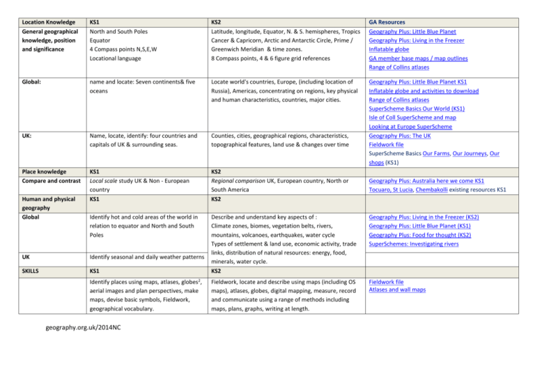
Location Knowledge General geographical knowledge, position and significance KS1 North and South Poles Equator 4 Compass points N,S,E,W Locational language KS2 Latitude, longitude, Equator, N. & S. hemispheres, Tropics Cancer & Capricorn, Arctic and Antarctic Circle, Prime / Greenwich Meridian & time zones. 8 Compass points, 4 & 6 figure grid references GA Resources Geography Plus: Little Blue Planet Geography Plus: Living in the Freezer Inflatable globe GA member base maps / map outlines Range of Collins atlases Global: name and locate: Seven continents& five oceans Locate world's countries, Europe, (including location of Russia), Americas, concentrating on regions, key physical and human characteristics, countries, major cities. UK: Name, locate, identify: four countries and capitals of UK & surrounding seas. Counties, cities, geographical regions, characteristics, topographical features, land use & changes over time Geography Plus: Little Blue Planet KS1 Inflatable globe and activities to download Range of Collins atlases SuperScheme Basics Our World (KS1) Isle of Coll SuperScheme and map Looking at Europe SuperScheme Geography Plus: The UK Fieldwork file SuperScheme Basics Our Farms, Our Journeys, Our shops (KS1) Place knowledge Compare and contrast KS1 Local scale study UK & Non - European country KS1 KS2 Regional comparison UK, European country, North or South America KS2 Identify hot and cold areas of the world in relation to equator and North and South Poles Geography Plus: Living in the Freezer (KS2) Geography Plus: Little Blue Planet (KS1) Geography Plus: Food for thought (KS2) SuperSchemes: Investigating rivers Fieldwork file Atlases and wall maps Human and physical geography Global UK Identify seasonal and daily weather patterns SKILLS KS1 Describe and understand key aspects of : Climate zones, biomes, vegetation belts, rivers, mountains, volcanoes, earthquakes, water cycle Types of settlement & land use, economic activity, trade links, distribution of natural resources: energy, food, minerals, water cycle. KS2 Identify places using maps, atlases, globes2, aerial images and plan perspectives, make maps, devise basic symbols, Fieldwork, geographical vocabulary. Fieldwork, locate and describe using maps (including OS maps), atlases, globes, digital mapping, measure, record and communicate using a range of methods including maps, plans, graphs, writing at length. geography.org.uk/2014NC Geography Plus: Australia here we come KS1 Tocuaro, St Lucia, Chembakolli existing resources KS1
