In the Northern Hemisphere, planetary winds
advertisement
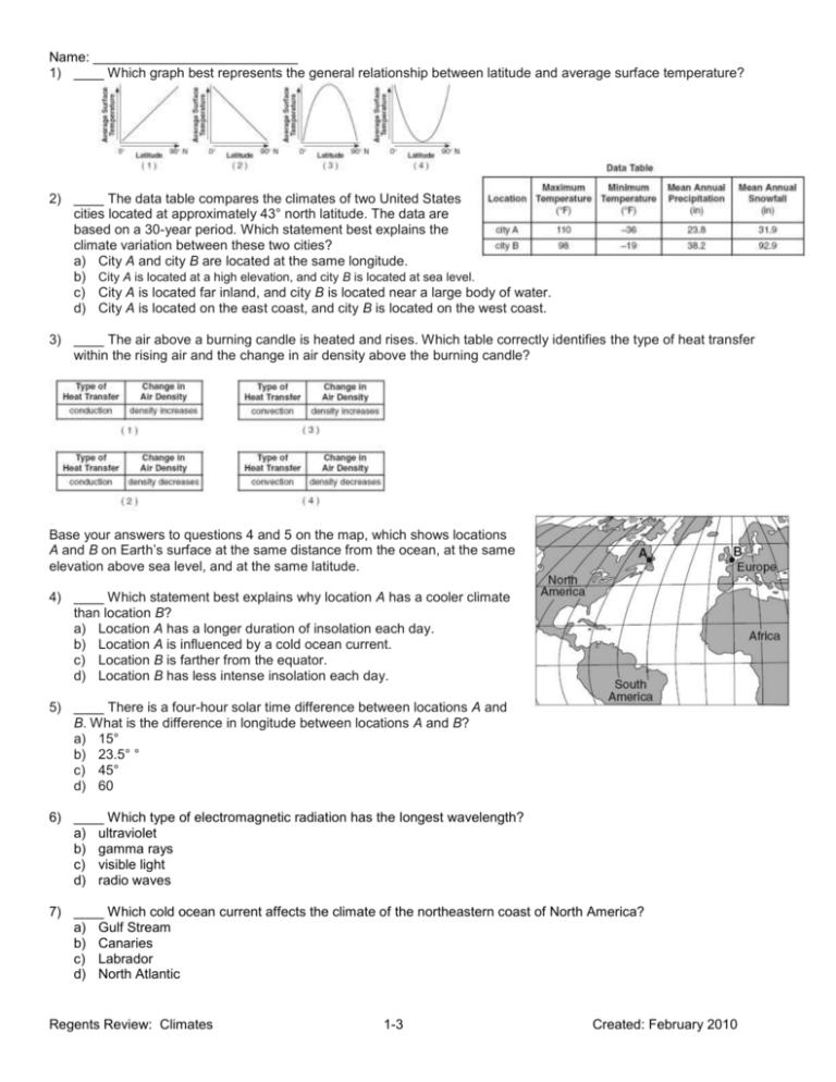
Name: ___________________________ 1) ____ Which graph best represents the general relationship between latitude and average surface temperature? 2) ____ The data table compares the climates of two United States cities located at approximately 43° north latitude. The data are based on a 30-year period. Which statement best explains the climate variation between these two cities? a) City A and city B are located at the same longitude. b) City A is located at a high elevation, and city B is located at sea level. c) City A is located far inland, and city B is located near a large body of water. d) City A is located on the east coast, and city B is located on the west coast. 3) ____ The air above a burning candle is heated and rises. Which table correctly identifies the type of heat transfer within the rising air and the change in air density above the burning candle? Base your answers to questions 4 and 5 on the map, which shows locations A and B on Earth’s surface at the same distance from the ocean, at the same elevation above sea level, and at the same latitude. 4) ____ Which statement best explains why location A has a cooler climate than location B? a) Location A has a longer duration of insolation each day. b) Location A is influenced by a cold ocean current. c) Location B is farther from the equator. d) Location B has less intense insolation each day. 5) ____ There is a four-hour solar time difference between locations A and B. What is the difference in longitude between locations A and B? a) 15° b) 23.5° ° c) 45° d) 60 6) ____ Which type of electromagnetic radiation has the longest wavelength? a) ultraviolet b) gamma rays c) visible light d) radio waves 7) ____ Which cold ocean current affects the climate of the northeastern coast of North America? a) Gulf Stream b) Canaries c) Labrador d) North Atlantic Regents Review: Climates 1-3 Created: February 2010 Name: ___________________________ 8) ____ Which event temporarily slows or reverses surface ocean currents in the equatorial region of the Pacific Ocean, causing a disruption of normal weather patterns? a) tsunami b) volcanic eruption c) El Niño d) deforestation 9) ____ Increasing the amount of carbon dioxide in Earth’s atmosphere increases atmospheric temperature because the carbon dioxide absorbs a) incoming solar gamma ray radiation b) incoming solar visible light radiation c) outgoing terrestrial ultraviolet radiation d) outgoing terrestrial infrared radiation Base your answers to questions 10 through 12 on the map below, which shows an imaginary continent on a planet that has climate conditions similar to Earth. The continent is surrounded by oceans. Two mountain ranges are shown. Points A through D represent locations on the continent. 10) Identify one labeled latitude on this continent where a high-pressure zone exists and dry air is sinking to the surface. Include both the unit and compass direction in your answer. ___________________________ 11) Identify one factor that causes a colder climate at location B than at location A. 12) Explain why location C has a warmer and drier climate than location D. 13) ____ Which coastal location experiences a cooler summer climate due to ocean currents? a) southeast coast of North America b) northeast coast of Australia c) southwest coast of South America d) northwest coast of Europe Regents Review: Climates 2-3 Created: February 2010 Name: ___________________________ 14) ____ The table below shows the latitude and the average yearly temperature for four different cities. It can be inferred from this table that the cities at higher latitudes have a) lower average yearly temperatures because these cities receive insolation at a higher angle during the year b) lower average yearly temperatures because these cities receive insolation at a lower angle during the year c) higher average yearly temperatures because these cities receive insolation at a higher angle during the year d) higher average yearly temperatures because these cities receive insolation at a lower angle during the year Base your answers to questions 15 and 16 on the diagram below, which shows air movement over a mountain range. The arrows indicate the direction of airflow. Points 1 through 3 represent locations on Earth’s surface. 15) ____ Compared to the climate at location 1, the climate at location 3 is a) cooler and drier b) cooler and wetter c) warmer and drier d) warmer and wetter 16) ____ Cloud formation at location 2 is the direct result of air that is rising, a) expanding, and cooling b) expanding, and warming c) compressing, and cooling d) compressing, and warming Base your answers to questions 17 and 18 on the diagram, which shows incoming solar radiation passing through the glass of a greenhouse and then striking the floor. 17) Some of the incoming solar radiation is absorbed by the floor. Identify the type of electromagnetic energy reradiated by the floor. ______________________________________ 18) Describe one way the glass in the greenhouse acts like the greenhouse gases in Earth’s atmosphere. Regents Review: Climates 3-3 Created: February 2010
