Thermohaline fields in the Mediterranean Sea.
advertisement
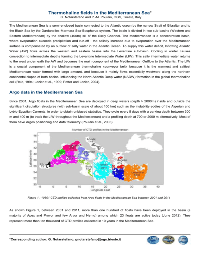
Thermohaline fields in the Mediterranean Sea* G. Notarstefano and P.-M. Poulain, OGS, Trieste, Italy The Mediterranean Sea is a semi-enclosed basin connected to the Atlantic ocean by the narrow Strait of Gibraltar and to the Black Sea by the Dardanelles-Marmara Sea-Bosphorus system. The basin is divided in two sub-basins (Western and Eastern Mediterranean) by the shallow (400m) sill of the Sicily Channel. The Mediterranean is a concentration basin, where evaporation exceeds precipitation and run-off : the salinity increase due to evaporation over the Mediterranean surface is compensated by an outflow of salty water in the Atlantic Ocean. To supply this water deficit, Inflowing Atlantic Water (AW) flows across the western and eastern basins into the Levantine sub-basin. Cooling in winter causes convection to intermediate depths forming the Levantine Intermediate Water (LIW). This salty intermediate water returns to the west underneath the AW and becomes the main component of the Mediterranean Outflow to the Atlantic. The LIW is a crucial component of the Mediterranean thermohaline «conveyor belt» because it is the warmest and saltiest Mediterranean water formed with large amount, and because it mainly flows essentially westward along the northern continental slopes of both basins, influencing the North Atlantic Deep water (NADW) formation in the global thermohaline cell (Reid, 1994; Lozier et al., 1999; Potter and Lozier, 2004). Argo data in the Mediterranean Sea Since 2001, Argo floats in the Mediterranean Sea are deployed in deep waters (depth > 2000m) inside and outside the significant circulation structures (with sub-basin scale of about 100 km) such as the instability eddies of the Algerian and Lybio-Egyptian Currents, in order to obtain unbiased statistics. They cycle every 5 days with a parking depth between 300 m and 400 m (to track the LIW throughout the Mediterranean) and a profiling depth at 700 or 2000 m alternatively. Most of them have Argos positioning and data telemetry (Poulain et al., 2006). Figure 1 : 10801 CTD profiles collected from Argo floats in the Mediterranean Sea between 2001 and 2011 As shown Figure 1, between 2001 and 2011, more than one hundred of floats have been deployed in the basin (a majority of Apex and Provor and few Arvor and Nemo) among which 23 floats are active today (June 2012). They represent more than ten thousand of CTD profiles collected in 10 years in the Mediterranean Sea. *Corresponding author: G. Notarstefano, gnotarstefano@ogs.trieste.it Thermohaline fields In the Mediterranean Sea, thermohaline fields are significantly variable (in space and time), mainly at surface and middepth levels. First, statistics have been calculated from Argo data in the Mediterranean Sea to obtain the long term variations in the thermohaline properties for each sub-basin (Notarstefano and Poulain, 2009). Monthly mean or maximum of potential temperature and salinity (ϑ,S) have been calculated near the surface, 600m (figure 2) and 2000 m in the most sampled Mediterranean sub-basins from more than 10000 float profiles from July 2001 and December 2011. Figure 2 : Mean potential temperature (left) and salinity (right) per month around 600 m in all Mediterranean sub-basins This work allows to reconstruct the main spatial structures of salinity and temperature in the entire Mediterranean between 0 and 700 m and at the salinity maximum. First results (Figure 3) show an apparent increasing of the salinity maximum in the Levantine basin from 2001 to 2009, followed by a negative trend.. Levantine Intermediate Water (LIW) Figure 3 : Mean salinity per month at the salinity maximum in the Mediterranean Sea, from July 2001 to December 2011. A further confirmation of the large temperature and salinity variability and of the consequent difficulty of detecting trend in the Mediterranean sub-basins using Argo floats for the Tyrrhenian Sea (Figure 4). The spatial mean (over the sub-basin) and the extreme values of T and S at 615 m reconstructed by 6 numerical Argo floats are plotted together with the mean values directly computed from the Eulerian MFS (Mediterranean Forecasting Model) model. Figure 4 : Mean T (left) and S (right) values reconstructed by 6 Argo numerical floats in the Tyrrhenian Sea at 615 m (black curve) with minimal and maximal values sampled (crosses). The red curve indicates the mean value computed at the same depth from the Eulerian model (all data), (Poulain et al., 2009). The maximal variability around mean values sampled by the numerical Argo floats is about 0.5°C and 0.15 psu, for T and S respectively. In such situation, and even at the intermediate depth of 615 m, the sparse sampling with Argo floats results in oscillations or apparent trend (see e.g. Figure 4 for temperature) that are not present when averaging all the model values. Monthly statistics might not be robust and biases could be induced by limited and non uniform sampling. References Lozier, M. S., Owens, W. B., and Curry, R. G (1995). The climatology of the North Atlantic, Prog. Oceanogr., 36, 1–44. Notarstefano, G. and P.-M. Poulain (2009). Thermohaline variability in the Mediterranean and Black Seas as observed by Argo floats in 2000-2009. OGS Tech. Rep. OGS 2009/121 OGA 26 SIRE, 72 pp. Potter, R. A. and Lozier (2004). M. S.: On the warming and salinification of the Mediterranean outflow waters in the North Atlantic, Geophys. Res. Lett., 31, L01202, doi:10.1029/2003GL018161. Poulain, P.-M., R. Barbanti, J. Font, A. Cruzado, C. Millot, I. Gertman, A. Griffa, A. Molcard, V. Rupolo, S. Le Bras, and L. Petit de la Villeon (2007). MedArgo: a drifting profiler program in the Mediterranean Sea. Ocean Sci., 3, 379-395. Poulain, P.M., M. Solari, Notarstefano G. and Volfango Rupolo (2009). Assessment of the Argo sampling in the Mediterranean and Black Seas (part II) OGS 2009/139 OGA 32 SIRE. Trieste, Italy. 23pp. Reid, J. L (1994). On the total geostrophic circulation of the North Atlantic ocean: Flow patterns, tracers, and transports, Prog. Oceanogr., 33(1), 1–92.

