The diagnostic edaphic adjectives (site modifiers) used to
advertisement
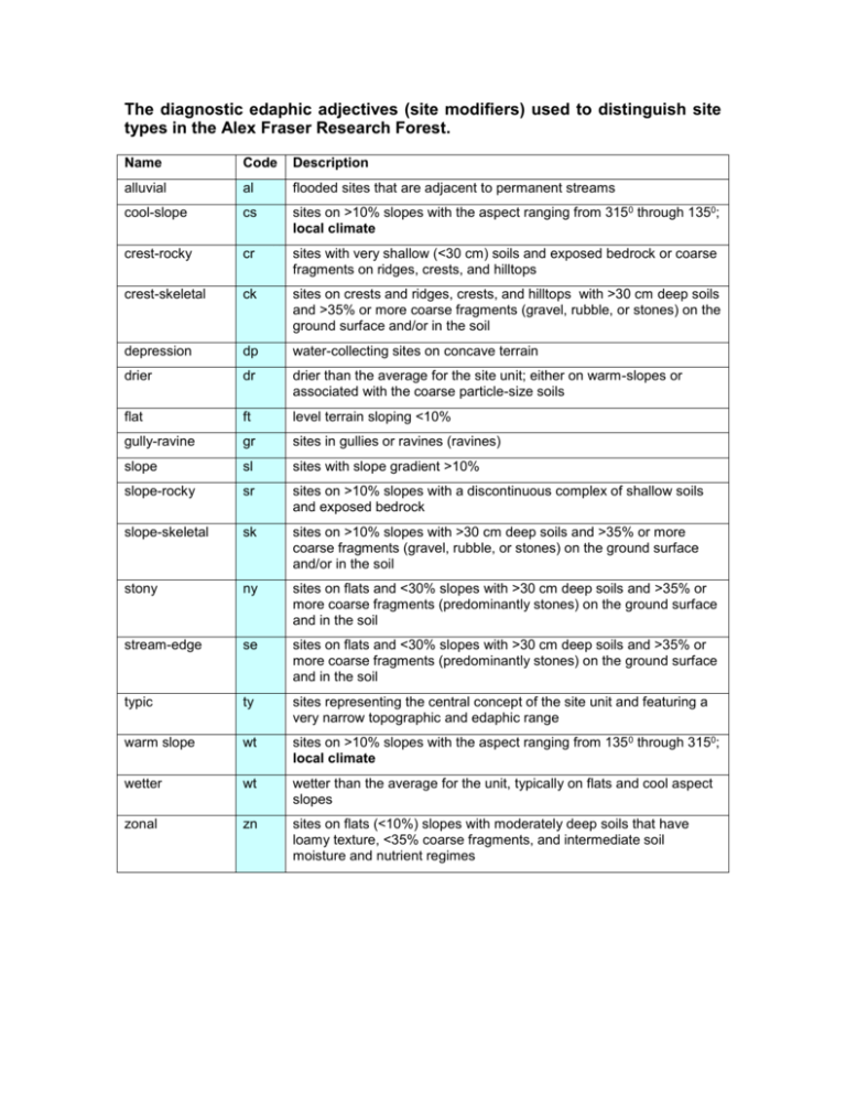
The diagnostic edaphic adjectives (site modifiers) used to distinguish site types in the Alex Fraser Research Forest. Name Code Description alluvial al flooded sites that are adjacent to permanent streams cool-slope cs sites on >10% slopes with the aspect ranging from 3150 through 1350; local climate crest-rocky cr sites with very shallow (<30 cm) soils and exposed bedrock or coarse fragments on ridges, crests, and hilltops crest-skeletal ck sites on crests and ridges, crests, and hilltops with >30 cm deep soils and >35% or more coarse fragments (gravel, rubble, or stones) on the ground surface and/or in the soil depression dp water-collecting sites on concave terrain drier dr drier than the average for the site unit; either on warm-slopes or associated with the coarse particle-size soils flat ft level terrain sloping <10% gully-ravine gr sites in gullies or ravines (ravines) slope sl sites with slope gradient >10% slope-rocky sr sites on >10% slopes with a discontinuous complex of shallow soils and exposed bedrock slope-skeletal sk sites on >10% slopes with >30 cm deep soils and >35% or more coarse fragments (gravel, rubble, or stones) on the ground surface and/or in the soil stony ny sites on flats and <30% slopes with >30 cm deep soils and >35% or more coarse fragments (predominantly stones) on the ground surface and in the soil stream-edge se sites on flats and <30% slopes with >30 cm deep soils and >35% or more coarse fragments (predominantly stones) on the ground surface and in the soil typic ty sites representing the central concept of the site unit and featuring a very narrow topographic and edaphic range warm slope wt sites on >10% slopes with the aspect ranging from 135 0 through 3150; local climate wetter wt wetter than the average for the unit, typically on flats and cool aspect slopes zonal zn sites on flats (<10%) slopes with moderately deep soils that have loamy texture, <35% coarse fragments, and intermediate soil moisture and nutrient regimes Table ? Block. Site series codes Mapping legend for the ICHmk3 portion of the Gavin Lake Abbreviated revised site series name Corresponding BC Forest Service site series name Site type codes Site type name 02 or CD/cr 02 or CD/sr 02 or CD/sy crest-rocky slope-rocky slope-stony 03 or CH/ck 03 or CH/sk 03 or CH/ny crest-skeletal slope-skeletal stony 01 or PT/dr 01 or PT/sl 01 or PT/zn drier slope zonal 05 or LO/fd 05 or PE/cs flat-depression cool-slope 04 or GY/ft 04 or GY/sl 04 or GY/gd flat slope gully-depression 06 or SR/sl 06 or SR/gd 06 or SR/al slope gully-depression alluvial 09 or EQ/dp 09 or EQ/al depression alluvial ICHmk3 variant 02 or CD Cladonia FdCw−Wavy-leaved moss 03 or CH Chimaphila CwSxw−Soopalallie 01 or PT Ptilium CwSxw−Falsebox−Knight’s plume 05 or LO Lonicera Sxw−Twinberry−Coltsfoot 04 or GY Gymnocarpium CwSxw−Oak fern−Cat’s-tail moss 06 or SR Streptopus CwHw−Devil’s club− Lady fern 07 or EQ Equisetum CwSxw−Devil’s club−Horsetail
