Stats for September 2009
advertisement
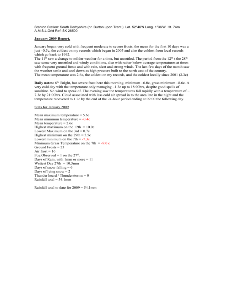
Stanton Station: South Derbyshire (nr. Burton upon Trent.) Lat. 52°46'N Long. 1°36'W Ht. 74m A.M.S.L.Grid Ref: SK 26500 January 2009 Report. January began very cold with frequent moderate to severe frosts, the mean for the first 10 days was a just –0.5c, the coldest on my records which began in 2005 and also the coldest from local records which go back to 1992. The 11th saw a change to milder weather for a time, but unsettled. The period from the 12 th t the 28th saw some very unsettled and windy conditions, also with rather below average temperatures at times with frequent ground frosts and with rain, sleet and strong winds. The last few days of the month saw the weather settle and cool down as high pressure built to the north east of the country. The mean temperature was 2.6c, the coldest on my records, and the coldest locally since 2001 (2.3c) Daily notes: 6th Bright, but severe frost here this morning, minimum –6.0c, grass minimum –8.6c. A very cold day with the temperature only managing –1.3c up to 18:00hrs, despite good spells of sunshine. No wind to speak of. The evening saw the temperatures fall rapidly with a temperature of – 7.3c by 21:00hrs. Cloud associated with less cold air spread in to the area late in the night and the temperature recovered to 1.2c by the end of the 24-hour period ending at 09:00 the following day. Stats for January 2009 Mean maximum temperature = 5.6c Mean minimum temperature = -0.4c Mean temperature = 2.6c Highest maximum on the 12th = 10.0c Lowest Maximum on the 3rd = 0.7c Highest minimum on the 29th = 5.5c Lowest minimum on the 7th = -7.3c Minimum Grass Temperature on the 7th = -9.0 c Ground Frosts = 23 Air frost = 16 Fog Observed = 1 on the 27th. Days of Rain, with 1mm or more = 11 Wettest Day 27th = 10.3mm Days of snow falling = 6 Days of lying snow = 2 Thunder heard / Thunderstorms = 0 Rainfall total = 54.1mm Rainfall total to date for 2009 = 54.1mm Stanton Station: South Derbyshire (nr. Burton upon Trent.) Lat. 52°46'N Long. 1°36'W Ht. 74m A.M.S.L.Grid Ref: SK 26500 February 2009 Report. A month of two extremes, with the first two weeks producing a mean of just 0.6c and the final two weeks producing a mean of 7.5c. A very cold first week with hard frosts and frequent moderate snowfalls with the wind blowing mostly from an easterly or north easterly point. The second week a little less cold and a little more settled, but with continued slight to moderate frosts every night. The final two weeks were very much on the mild side and very dry with only 0.3mm of rain recorded and hardly any frost recorded at all. Despite the dryness, it was a very cloudy and dull period with little sunshine around. The final mean was 4.1c. Average for this area. Daily notes: 2nd: Intermittent moderate snow overnight has left a cover of 5.5cm, and with a fresh NE wind, a severe penetrating frost, with an air minimum of –2.5c and –6.6c on the snow. At observation, heavy blowing snow with drifting in a gusting NE wind. The day continued with heavy snow at times, though with a much lighter wind. The snow cover ranged from 13 to 18cm by 19:00hrs. The evening saw the snow petering out with a slow thaw following. Winter 2008 / 2009: The winter on the whole was colder than in recent years, with frequent cold spells which gave much frosts and snowfall, especially during early February. The Mean was 3.2c, being the coldest winter from local data since 1995 / 6, -0.9c below average. Stats for February 2009 Mean maximum temperature = 6.8c Mean minimum temperature = 1.3c Mean temperature = 4.1c Highest maximum on the 25th = 11.8c Lowest Maximum on the 2nd = 0.7c Highest minimum on the 25th = 7.3c Lowest minimum on the 7th = -6.2c Minimum Grass Temperature on the 7th = -9.4 c Ground Frosts = 16 Air frost = 8 Fog Observed = 1 on the 9th. Days of Rain, with 1mm or more = 6 Wettest Day 9th = 9.1mm Days of snow falling = 7 Days of lying snow at 09:00 GMT = 8 Thunder heard / Thunderstorms = 0 Rainfall total = 32.7mm Rainfall total to date for 2009 = 86.8mm Stanton Station: South Derbyshire (nr. Burton upon Trent.) Lat. 52°46'N Long. 1°36'W Ht. 74m A.M.S.L.Grid Ref: SK 26500 March 2009 Report. An unsettled start to the month with Atlantic driven conditions, quite windy at times, especially on the 9th with a SSW gust of 42mph. The temperatures were close to or a little below average as the nights were often clear and chilly. The period form the 11th to the 22nd saw settled conditions with high pressure in control, nights were chilly here with ground frost and fog, the days were at times mild and sunny, but Stratocumulus cloud was stubborn to clear on a number of days which resulted in low maximums. By the 23rd the high had retreated southwestward and allowed low pressure from the Atlantic to make inroads in to the UK. The weather turned very unsettled and windy here with gusts exceeding 40mph on 23rd, 25th and 26th, rainfall amounts however were only small. Pressure begin to rise towards the end of the month giving a settled and rather warm end. Summary: A dry month with only 31.3mm of rain, the driest March locally since 2003 (20.3mm) Windy at times for this area with gusts exceeding 40mph on 4 days of the month. There were also quite a few mild and sunny days noted with the high maximum for the month being 15.9c on the 31st. Cloud cover at 09:00hrs averaged at 57%. The mean temperature of 6.6c was slightly above average for this area. (6.3c) Daily notes: Quite a few sunny days were noted here, but one day, the 29 th stands out amongst the others. The atmosphere had been left clear and clean from a northerly air stream on the previous day. After a frosty start, wall to wall sunshine ensued shining from a crystal clear and deep blue sky, the temperature only peaked near 10c, but with just a very light wind it was a beautiful spring day indeed, and a rare day in these modern polluted times. Stats for March 2009 Mean maximum temperature = 11.1c Mean minimum temperature = 2.2c Mean temperature = 6.6c Highest maximum on the 31st = 15.9c Lowest Maximum on the 4th = 6.7c Highest minimum on the 14th = 7.9c Lowest minimum on the 6th = -3.5c Minimum Grass Temperature on the 6th = -6.1 c Ground Frosts = 16 Air frost = 10 Fog Observed = 1 on the 18th. Days of Rain, with 1mm or more = 7 Wettest Day 3rd = 12.0mm Days of snow falling = 1 on the 4th. Days of lying snow at 09:00 GMT = 0 Thunder heard / Thunderstorms = 0 Rainfall total = 31.3mm Rainfall total to date for 2009 = 118.1mm Stanton Station: South Derbyshire (nr. Burton upon Trent.) Lat. 52°46'N Long. 1°36'W Ht. 74m A.M.S.L.Grid Ref: SK 26500 April 2009 Report. Well above average temperature wise, though not quite as warm as April 2007. Only 1 slight air frost was recorded, but that was 1 more than in April 2007. Dry for the most part with just 17mm of rain recorded up to the 24 th, but there was quite a wet period from the 25th to the 28th, the wettest day was on the 27th with 17mm. Summary: Daily notes: Stats for April 2009 Mean maximum temperature = 15.2c Mean minimum temperature = 5.5c Mean temperature = 10.3c Highest maximum on the 20th = 19.5c Lowest Maximum on the 27th = 9.7c Highest minimum on the 10th = 9.7c Lowest minimum on the 5th = -0.9c Minimum Grass Temperature on the 5th = -3.4 c Ground Frosts = 7 Air frost = 1 Fog Observed = 1 on the 3rd. Days of Rain, with 1mm or more = 8 Wettest Day 27th = 17.1mm Days of snow falling = 0. Days of lying snow at 09:00 GMT = 0 Thunder heard / Thunderstorms = 1 on the 15th Rainfall total = 45.4mm Rainfall total to date for 2009 = 163.5mm Stanton Station: South Derbyshire (nr. Burton upon Trent.) Lat. 52°46'N Long. 1°36'W Ht. 74m A.M.S.L.Grid Ref: SK 26500 May 2009 Report. A rather unsettled start with average temperatures. A short fine spell from the 10th through to the 12th produced almost cloudless skies, but with very windy conditions at times, a north easterly gust of 43mph was recorded here on the 12th. Unsettled conditions returned by the 13th with overcast, dull and rainy conditions. By the end of the 24-hour at 09:00GMT on the 14th, 21.2mm of rain had been recorded making it the wettest 24 hours of the year so far. A further 20.7mm of rain had fallen by 09:00GMT on the 15 th. The weather was less unsettled for a time up to the 24th with a few pleasant sunny days noted. More rain fell from the 25 th to the 27th. Finally the weather settled down on the 28th with the 29th producing the hottest day of the year so far with a maximum of 25.0c. Fine sunny weather continued to the end of the month. Summary: A mixed month with unsettled, cool and wet spells mixed with and fine warm to very warm sunny spells. Overall the temperature was above average. Daily notes: 12th: An unusual day with almost an cloudless sky and unbroken sunshine, but very windy with a north easterly gust of 43mph recorded here. 13th-14th: A very wet 24hours with 21.2mm of rain. 19th: Moderate intensity thunderstorm during the afternoon, lighting strikes very close to this station. Stats for May 2009 Mean maximum temperature = 17.3c Mean minimum temperature = 7.5c Mean temperature = 12.4c + 1.0c Highest maximum on the 29th = 25.0c Lowest Maximum on the 14th = 12.6c Highest minimum on the 29th = 11.9c Lowest minimum on the 10th = 2.5c Minimum Grass Temperature on the 4th = -0.1 c Ground Frosts = 1 Air frost = 0 Fog Observed = 0 Days of Rain, with 1mm or more = 9 Wettest Day 14th = 21.2mm Days of snow falling = 0. Days of lying snow at 09:00 GMT = 0 Thunder heard / Thunderstorms = 1 on the 19th Rainfall total = 73.4mm Rainfall total to date for 2009 = 236.9mm June 2009 Report. A hot and sunny start to June with 27.0c being reached by the 2 nd, but it didn’t last. By the 3rd the maximum temperature had fallen to 15.2c under an overcast sky and a chilly feeling NE wind. By the 6th the maximum temperature was only 11.7c, the coldest June day locally since 1997 (10.2c) The 7th was thundery and again very cool for June with a temperature only managing 11.1c by 18:00GMT, though 12.0c was reached by the end of the 24 hour period ending at 09:00GMT, it was also the wettest day of the year so far with 23.3mm of rain. After a cold night on the 12th, minimum 3.3c, conditions became more settled with a return to pleasant warm and sunny days. The 17th to the 19th saw a rather more unsettled, breezy and cooler spell of weather. The 20th saw the weather settled in to a very warm to hot period, which continued until the end of the month. Overall the mean temperature was above average. Summary: Daily notes: 4th: A very cool night for June, minimum temperature 2.3c and 0.5c on the grass. 12th Another very cool night, minimum temperature 3.3c and 1.1c on the grass. 13th: In complete contrast to the 12th cold start; it was a good deal warmer this morning after a very mild and overcast night, minimum temperature only down to 13.6c, warmer than two maximums last week and the warmest night since 11th September last year (13.7c). Stats for June 2009 Mean maximum temperature = 20.5c Mean minimum temperature = 10.0c Mean temperature = 15.3c + 1.0c Highest maximum on the 29th = 27.4c Lowest Maximum on the 6th = 11.7c Highest minimum on the 27th = 16.0c Lowest minimum on the 4th = 2.3c Minimum Grass Temperature on the 4th = 0.5 c Ground Frosts = 0 Air frost = 0 Fog Observed = 0 Days of Rain, with 1mm or more = 6 Wettest Day 7th = 23.3mm Days of snow falling = 0. Days of lying snow at 09:00 GMT = 0 Thunder heard / Thunderstorms = 3 on the 7th, 10th, 29 th Highest wind gust = 32mph on the 7th. Rainfall total = 61.6mm Rainfall total to date for 2009 = 298.5mm Stanton Station: South Derbyshire (nr. Burton upon Trent.) Lat. 52°46'N Long. 1°36'W Ht. 74m A.M.S.L.Grid Ref: SK 26500 July 2009 Report. A very warm start to the month, with the temperatures well above average for the first few days. The mean after the first 5 days was 20.8c. Very unsettled and very wet conditions followed, which continued unabated until the end of the month. Days were often thundery with 7 days of thunder recorded. The very warm start was wiped out by persistent average or slightly below average temperatures. The mean eventually finished up at 16.2c, slightly below the local average. Rainfall total was 158.2mm, 342% of the local average. Daily notes: 1st: The warmest night of the year, minimum 18.5c, also the warmest night since July 2006, (19.2c). The 1st also produced the hottest day of the year so far, 30.4c. It was also the hottest day since July 2006 (32.7c) 3rd: The hot spell came to an abrupt end with a moderate to severe thunderstorm and torrential rain at this location before the observation at 09:00GMT. 29th: Continuous moderate to heavy rain all day giving a total of 21.8mm. 30th: A day of heavy showers, including a moderate intensity thunderstorm with hail around midday. Stats for July 2009 Mean maximum temperature = 20.8c Mean minimum temperature = 11.7c Mean temperature = 16.2c -0.5c Highest maximum on the 1st = 30.4c Lowest Maximum on the 30th = 16.2c Highest minimum on the 1st = 18.5c Lowest minimum on the 31st = 6.2c Minimum Grass Temperature on the 1st = 4.5 c Ground Frosts = 0 Air frost = 0 Fog Observed =1 on the 14th Days of Rain, with 1mm or more = 21 Total rain days = 27 Wettest Day 29th = 21.8mm Days of snow falling = 0. Days of lying snow at 09:00 GMT = 0 Thunder heard / Thunderstorms = 7 on the 2, 6, 7, 14, 24, 27 and 30th Highest wind gust = 32mph on the 17th. Rainfall total = 158.2mm Rainfall total to date for 2009 = 456.7mm August 2009 Report. The unsettled rainy weather which dominated throughout July, carried through to the first week of August. Conditions improved during the second and third weeks with more sunshine and warmth. Another changeable pattern of weather developed again by the 20 th, with rather windy weather at times and some light rain. Temperatures stayed close to the average. Rainfall was 98.7% of the local average. Daily notes: Stats for August 2009 Mean maximum temperature = 21.2c Mean minimum temperature = 12.3c Mean temperature = 16.7c + 0.3c Highest maximum on the 19th = 26.2c Lowest Maximum on the 1st = 16.7c Highest minimum on the 5th = 17.0c Lowest minimum on the 2nd = 6.9c Minimum Grass Temperature on the 22nd = 4.3 c Ground Frosts = 0 Air frost = 0 Fog Observed =0 Days of Rain, with 1mm or more = 11 Total rain days = 17 Wettest Day 6th = 10.6mm Days of snow falling = 0. Days of lying snow at 09:00 GMT = 0 Thunder heard / Thunderstorms = 1 on the 25th. Highest wind gust = 31.5mph on the 15th. Rainfall total = 49.3mm 98.7% Rainfall total to date for 2009 = 506.0mm Summer 2009 The summer started fine and warm with June producing 15 day with the temperature equalling or exceeding 21c, 6 of those equalled 25c or more. July turned thoroughly wet and was also thundery with 158mm of rain, 342% of the local average. The temperatures were slightly below the long term local average. August was warmer and drier than July producing 20 days when the temperature equalled or exceeded 21c. Rainfall total was 49.3mm, slightly below the local average. The mean temperature was slightly above average. Overall the summer was wet, but slightly warmer than average. Stats Mean maximum temperature = 20.8c Mean minimum temperature = 11.3c Mean temperature = 16.1c + 0.3c Highest maximum on the 1st July = 30.4c Lowest minimum on the 4th June = 2.3c Minimum Grass Temperature on the 4th June = 0.5 c Ground Frosts = 0 Air frost = 0 Rain total = 269.1mm 176.2% September 2009 Report. After an unsettled and rather windy first week, very dry, settled and rather warm conditions took over during the second week, this continued to the end of the month producing drought conditions with 22 consecutive dry days recorded here. Not surprisingly rainfall was well below average, with just 14.0mm, 26% of the average, which all fell during the first week. The mean temperature came in at 14.1c, slightly above the local average. Daily notes: Stats for September 2009 Mean maximum temperature = 18.5c Mean minimum temperature = 9.6c Mean temperature = 14.1c + 0.6c Highest maximum on the 8th = 23.5c Lowest Maximum on the 17th = 15.2c Highest minimum on the 8th = 16.6c Lowest minimum on the 27th = 4.3c Minimum Grass Temperature on the 24th = 2.0 c Ground Frosts = 0 Air frost = 0 Fog Observed = 1 on the 27th Days of Rain, with 1mm or more = 3 Total rain days = 5 Wettest Day 2nd = 8.9mm Days of snow falling = 0. Days of lying snow at 09:00 GMT = 0 Thunder heard / Thunderstorms = 0 Highest wind gust = 37.9mph on the 3rd. Rainfall total = 14.0mm 26.2% Rainfall total to date for 2009 = 520.0mm
