Atmosphere as an Earth System Notes
advertisement
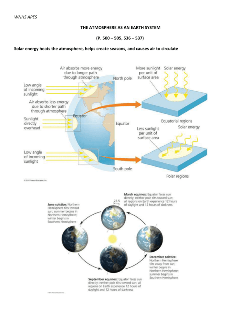
WNHS APES THE ATMOSPHERE AS AN EARTH SYSTEM (P. 500 – 505, 536 – 537) Solar energy heats the atmosphere, helps create seasons, and causes air to circulate CONVECTIVE CIRCULATION – Air at Earth’s surface is warmer and moister than air at high altitudes; warm air is less dense so it rises and makes vertical currents; as it rises it expands and cools causing it to descend and become denser This drives WEATHER and CLIMATE: Weather =specifies atmospheric conditions over short time periods and within small geographic areas Climate =patterns of atmospheric conditions across large geographic regions over long periods of time Circulation systems produce climate patterns Hadley cells =convective cells near the equator Surface air warms, rises, and expands causing heavy rainfall near the equator and giving rise to tropical rainforests Currents heading north and south are dry giving rise to deserts at 30 degrees Ferrel cells and polar cells= lift air and create precipitation at 60 degrees latitude north and south Conditions at the poles are dry http://www.youtube.com/watch?v=DHrapzHPCSA Global wind patterns Atmospheric cells interact with Earth’s rotation to produce global wind patterns As Earth rotates, equatorial regions spin faster Coriolis effect =the apparent north-south deflection of air currents of the convective cells http://www.youtube.com/watch?v=mcPs_OdQOYU Northern Hemisphere – Southern Hemisphere - Doldrums= a region near the equator with few winds Trade winds = between the equator and 30 degrees; Blow from east to west Westerlies= from 30 to 60 degrees latitude; Blow from west to east Air circulation drives ocean circulation El Niño–Southern Oscillation (ENSO) ENSO= a systematic shift in atmospheric pressure, sea surface temperature, and ocean circulation in the tropical Pacific Ocean Normal winds blow east to west, from high to low pressure This forms a large convective loop in the atmosphere Winds push water west, causing it to “pile up” Nutrient-rich, cold water along Peru and Ecuador rises from the deep Decreased pressure in the eastern Pacific triggers El Niño Warm water flows eastward, suppressing upwellings http://esminfo.prenhall.com/science/geoanimations/animations/26_NinoNina.html http://www.youtube.com/watch?v=7FVZrw7bk1w http://www.youtube.com/watch?feature=endscreen&v=ovDp1crqdOU&NR=1 http://www.youtube.com/watch?v=IvmeUStFvz8&feature=related Effects of El Niño and La Niña Coastal industries (e.g., Peru’s anchovy fisheries) are devastated Worldwide, fishermen lost $8 billion in 1982–1983 Global weather patterns change Rainstorms, floods, drought, fires La Niña = the opposite of El Niño Cold waters rise to the surface and extend westward ENSO cycles are periodic but irregular (every 2–8 years) Globally warming sea and air may be increasing the strength and frequency of these cycles

