CT254 - Mohawk Valley Community College
advertisement
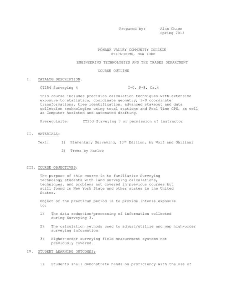
Prepared by: Alan Chace Spring 2013 MOHAWK VALLEY COMMUNITY COLLEGE UTICA-ROME, NEW YORK ENGINEERING TECHNOLOGIES AND THE TRADES DEPARTMENT COURSE OUTLINE I. CATALOG DESCRIPTION: CT254 Surveying 4 C-0, P-8, Cr.4 This course includes precision calculation techniques with extensive exposure to statistics, coordinate geometry, 3-D coordinate transformations, tree identification, advanced stakeout and data collection technologies using total stations and Real Time GPS, as well as Computer Assisted and automated drafting. Prerequisite: II. CT253 Surveying 3 or permission of instructor MATERIALS: Text: 1) Elementary Surveying, 13th Edition, by Wolf and Ghiliani 2) Trees by Harlow III. COURSE OBJECTIVES: The purpose of this course is to familiarize Surveying Technology students with land surveying calculations, techniques, and problems not covered in previous courses but still found in New York State and other states in the United States. Object of the practicum period is to provide intense exposure to: IV. 1) The data reduction/processing of information collected during Surveying 3. 2) The calculation methods used to adjust/utilize and map high-order surveying information. 3) Higher-order surveying field measurement systems not previously covered. STUDENT LEARNING OUTCOMES: 1) Students shall demonstrate hands on proficiency with the use of total stations and data collector. V. 2) Students shall demonstrate proficiency with Computer Assisted Mapping and automated mapping techniques. 3) Students will learn the statistical analysis of Surveying error, and the methods of adjustment of that error. 4) Students will learn the basic techniques of Real Time GPS surveying. 5) Students will obtain a basic background in dendrology and tree identification. DETAILED COURSE OUTLINES Week Topic will vary) Reading 1 Error of Sunshots Chapter 3 C3, 2,3,6,11,16,25a,27a 2 EDM’s Calibration Chapter 6 C6, 1,20,24,27,37 3 Triangulation/Trilateration 4 Total Stations Intro to Carlson Chapter 8 5 Coordinate Geometry Carlson Lab 6 “ Collection 8 Line Fitting Examination Handouts Chapter 21 9 Data Collection Topography C19 to section 13. TBA C8, 3-8,12,20,30,31 Chapter 11 “ 7 Automated Mapping Reconnaisance Homework Handouts C11,1,7,9,15 Lab (schedule Analysis Total Station Deed Research Test one, Stakeout of C11, 17,18,21,36,37 Intro to Data Mining Claims Lab Project Per handout Midterm per handout Automated 10-11 Fieldwork on Class Project Collection and Reduction Data 12-13 CAD Mapping, Office work and Mapping of Class Project Test Two 13 Tree Identification 14 Tree Identification Harlow, 1st half RTK lab (hopefully) 15 Course Review Final Exam It needs to be emphasized that the actual lab schedule will differ greatly from this outline, due to the nature of the class project and weather limitations. DISABILITY STATEMENT I would appreciate hearing from anyone in the class who has any type of disability (e.g., physical, learning, psychiatric, vision, hearing, etc.) which may require some special accommodation. Please see me during my office hours so that we can discuss your needs. Before services can begin, you must also contact Lynn Igoe, Coordinator of Disability Services, 792-5413 (Voice or TTY), or the college Learning and Assistive Technology Specialist,731-5702; both are located in Room 153 of the Academic Building on the Utica Campus. (For classes on the Rome Campus, the contact person is Michael Badolato, PC A30, 3347718). They are the staff members who review your documentation, determine eligibility for accommodations, and help determine what those accommodations will be. COURSE NAME: DATE ___CT254 ____Surveying 4_________________________________________________________________ FACULTY NAME 2007 Chace 2009 Chace CHANGE New XYZ works data collectors. Robotic Total Station Demo. INPUT MEASUREMENT ASSESSMENT ACTION

![Elementary Surveying [Opens in New Window]](http://s3.studylib.net/store/data/007206959_1-5874c882e65124652f9ab700273bfabf-300x300.png)
