File - Canadian Geothermal Energy Association
advertisement
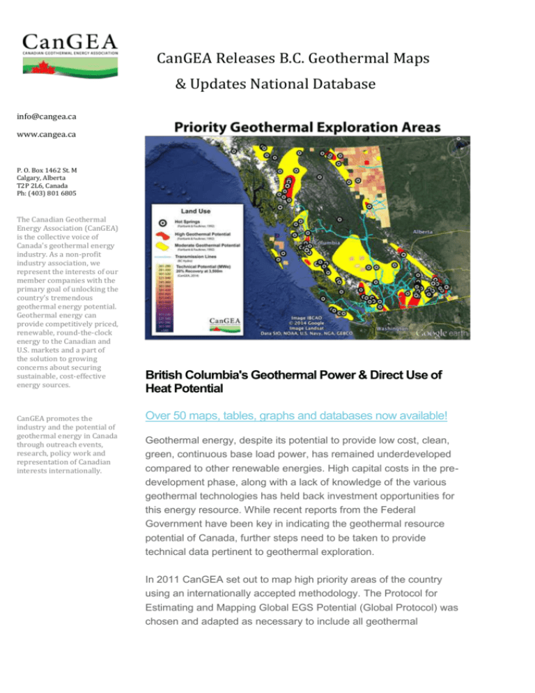
CanGEA Releases B.C. Geothermal Maps & Updates National Database info@cangea.ca www.cangea.ca P. O. Box 1462 St. M Calgary, Alberta T2P 2L6, Canada Ph: (403) 801 6805 The Canadian Geothermal Energy Association (CanGEA) is the collective voice of Canada's geothermal energy industry. As a non-profit industry association, we represent the interests of our member companies with the primary goal of unlocking the country's tremendous geothermal energy potential. Geothermal energy can provide competitively priced, renewable, round-the-clock energy to the Canadian and U.S. markets and a part of the solution to growing concerns about securing sustainable, cost-effective energy sources. CanGEA promotes the industry and the potential of geothermal energy in Canada through outreach events, research, policy work and representation of Canadian interests internationally. British Columbia's Geothermal Power & Direct Use of Heat Potential Over 50 maps, tables, graphs and databases now available! Geothermal energy, despite its potential to provide low cost, clean, green, continuous base load power, has remained underdeveloped compared to other renewable energies. High capital costs in the predevelopment phase, along with a lack of knowledge of the various geothermal technologies has held back investment opportunities for this energy resource. While recent reports from the Federal Government have been key in indicating the geothermal resource potential of Canada, further steps need to be taken to provide technical data pertinent to geothermal exploration. In 2011 CanGEA set out to map high priority areas of the country using an internationally accepted methodology. The Protocol for Estimating and Mapping Global EGS Potential (Global Protocol) was chosen and adapted as necessary to include all geothermal resources, not limited to Enhanced Geothermal Systems only. The Geothermal Code for Public Reporting (Reporting Code) was also used. The Alberta and British Columbia maps are believed to be the first examples of the use of both the Global Protocol and Reporting Code. This Global Protocol has been reviewed and endorsed by the International Geothermal Association (IGA), the Executive Committee of the International Energy Agency Geothermal Implementing Agreement, and the International Heat Flow Commission. The Reporting Code has received global recognition by the IGA and is currently being critically assessed by the World Bank as an appropriate prerequisite for World Bank project funding. Reporting under the Code must be carried out by a registered “Competent” or “Qualified” Person with demonstrated experience in resource/reserve estimation. In addition to adoption by some industry associations, there are multi-national energy companies who have adopted the Code for internal reporting and several geothermal consulting houses are applying the Code to resource assessments performed internationally. Both the Alberta and British Columbia map projects underwent an international peer review process by Dr. Graeme Beardsmore of Australia, who is a co-author of the Global Protocol and Reporting Code. He currently holds the role of Chairman of the Resources and Reserves Committee of the IGA. CanGEA is pleased to present this project which respects the Reporting Code’s underlying principles of ‘transparency’, ‘materiality’, and ‘competence’, and honours those principles by providing public access to the underlying data, metadata, charts and tables used in the assessment of British Columbia’s geothermal resources. The raw data itself is publicly available from the Province of B.C and the Canadian government. Key Findings of the Project include: 1. British Columbia has enormous potential to produce geothermal power. There is a sufficient developable resource to meet the entire Province’s power demand. The most conservative view of the Technical Potential of geothermal power in British Columbia is 5,500 MW using only “Indicated Resources” data. The value rises to 6,600 MW when “Indicated” and “Inferred” data is contemplated. This amount is considered achievable with current technology (binary power plants), accessible at the shallowest studied depth of 2,500m, and with the lowest studied recovery factor of 5%. These estimates are calculated under the “Geothermal Reporting Code” using an NTS grid system that only has data coverage in 23% of the Province. Further, it is well understood that the volcanic and crystalline rocks, which make up the preponderance of the ‘white space’ outside of BC’s current data coverage, have greater geothermal potential than the sedimentary zones, for which data exists. As such, an estimate of British Columbia’s full Technical Potential should be multiples of that calculated for the sedimentary zones, and therefore much more than the entire requirements of the Province. 2. There is significant room to improve both the Data Coverage and Confidence of the estimates of British Columbia’s geothermal potential Data Coverage: It was not within the scope of this project to acquire data. However, within British Columbia, there are many other sources of potentially useful data that could be easily acquired. These include taking relevant measurements from existing mining exploration and water wells. Currently, taking relevant geothermal measurements are not part of the required reporting for these activities. Confidence: Significant water production data exists from the Oil & Gas properties being exploited in northeast British Columbia. While not within the scope of this work, this information can be combined with the relevant thermal measurements to produce a “Measured Resource” estimate of the geothermal potential of specific reservoirs. This is a higher degree of confidence than “Indicated Resources” and “Inferred Resources”, where these reservoirs are currently categorized, and is a large step forward in moving between resource and reserve categories in the Geothermal Code for Public Reporting of Resources and Reserves. 3. Priority geothermal exploration areas are identified through the confluence of key surface and subsurface data. Progress at the Industry level is predicated on individual project success. Accordingly, priority exploration areas for geothermal energy production need to not only consider subsurface contexts but also highly relevant surface features (demand, transmission, roads, parks, lakes, etc.) that can greatly influence project economics. This is what CanGEA refers to as Favourability Maps. As the maps and geothermal database produced by this project are shared publicly via a web portal and Google Earth platform, virtually anyone now has the opportunity to learn about the geothermal potential in British Columbia. These maps will also help to identify regions of British Columbia with clearly defined data gaps where further research is recommended. CanGEA's newly released report, Direct Utilization of Geothermal Energy, is a helpful companion document to this project. Anyone interested in receiving assistance with these resource materials is encouraged to Ask a Geothermal Expert.
