Pacific Northwest Streams Supplement to Fact Sheet Opportunities
advertisement
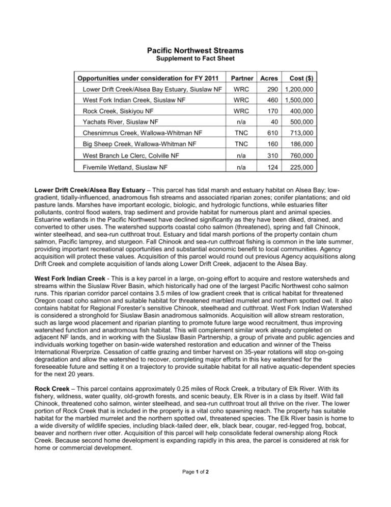
Pacific Northwest Streams Supplement to Fact Sheet Opportunities under consideration for FY 2011 Partner Acres Cost ($) Lower Drift Creek/Alsea Bay Estuary, Siuslaw NF WRC 290 1,200,000 West Fork Indian Creek, Siuslaw NF WRC 460 1,500,000 Rock Creek, Siskiyou NF WRC 170 400,000 n/a 40 500,000 Chesnimnus Creek, Wallowa-Whitman NF TNC 610 713,000 Big Sheep Creek, Wallowa-Whitman NF TNC 160 186,000 West Branch Le Clerc, Colville NF n/a 310 760,000 Fivemile Wetland, Siuslaw NF n/a 124 225,000 Yachats River, Siuslaw NF Lower Drift Creek/Alsea Bay Estuary – This parcel has tidal marsh and estuary habitat on Alsea Bay; lowgradient, tidally-influenced, anadromous fish streams and associated riparian zones; conifer plantations; and old pasture lands. Marshes have important ecologic, biologic, and hydrologic functions, while estuaries filter pollutants, control flood waters, trap sediment and provide habitat for numerous plant and animal species. Estuarine wetlands in the Pacific Northwest have declined significantly as they have been diked, drained, and converted to other uses. The watershed supports coastal coho salmon (threatened), spring and fall Chinook, winter steelhead, and sea-run cutthroat trout. Estuary and tidal marsh portions of the property contain chum salmon, Pacific lamprey, and sturgeon. Fall Chinook and sea-run cutthroat fishing is common in the late summer, providing important recreational opportunities and substantial economic benefit to local communities. Agency acquisition will protect these values. Acquisition of this parcel would round out previous Agency acquisitions along Drift Creek and complete acquisition of lands along Lower Drift Creek, adjacent to the Alsea Bay. West Fork Indian Creek - This is a key parcel in a large, on-going effort to acquire and restore watersheds and streams within the Siuslaw River Basin, which historically had one of the largest Pacific Northwest coho salmon runs. This riparian corridor parcel contains 3.5 miles of low gradient creek that is critical habitat for threatened Oregon coast coho salmon and suitable habitat for threatened marbled murrelet and northern spotted owl. It also contains habitat for Regional Forester’s sensitive Chinook, steelhead and cutthroat. West Fork Indian Watershed is considered a stronghold for Siuslaw Basin anadromous salmonids. Acquisition will allow stream restoration, such as large wood placement and riparian planting to promote future large wood recruitment, thus improving watershed function and anadromous fish habitat. This will complement similar work already completed on adjacent NF lands, and in working with the Siuslaw Basin Partnership, a group of private and public agencies and individuals working together on basin-wide watershed restoration and education and winner of the Theiss International Riverprize. Cessation of cattle grazing and timber harvest on 35-year rotations will stop on-going degradation and allow the watershed to recover, completing major efforts in this key watershed for the foreseeable future and setting it on a trajectory to provide suitable habitat for all native aquatic-dependent species for the next 20 years. Rock Creek – This parcel contains approximately 0.25 miles of Rock Creek, a tributary of Elk River. With its fishery, wildness, water quality, old-growth forests, and scenic beauty, Elk River is in a class by itself. Wild fall Chinook, threatened coho salmon, winter steelhead, and sea-run cutthroat trout all thrive on the river. The lower portion of Rock Creek that is included in the property is a vital coho spawning reach. The property has suitable habitat for the marbled murrelet and the northern spotted owl, threatened species. The Elk River basin is home to a wide diversity of wildlife species, including black-tailed deer, elk, black bear, cougar, red-legged frog, bobcat, beaver and northern river otter. Acquisition of this parcel will help consolidate federal ownership along Rock Creek. Because second home development is expanding rapidly in this area, the parcel is considered at risk for home or commercial development. Page 1 of 2 Yachats River – The parcel is part of the largest mature and old-growth coniferous stand (rare) along the lower Yachats River. The parcel is within Late Successional Reserve in the Tier 1 Yachats Key Watershed, in an Audubon designated Important Bird Area for the Marbled Murrelet, and in The Nature Conservancy’s priority conservation areas for the Coast Range Bioregion. It also contains critical habitat for threatened Oregon coast coho salmon, and northern spotted owl, and habitat for Regional Forester’s sensitive Chinook, steelhead, and cutthroat trout. About half of the parcel is riparian area. The parcel’s location along the Yachats River and county road make it an ideal opportunity to expand recreation for several different activities that already occur on the adjacent Forest lands, such as hunting, fishing, hiking, camping, and education. Habitat conversion (logging) of this parcel is very likely in the next few years. Clear-cut logging would substantially reduce ecosystem values of the parcel and the adjacent old-growth forest on Siuslaw National Forest. Acquisition of the parcel would build on past acquisition efforts in the basin, and fulfills conservation priorities in The Oregon Conservation Strategy 2006 by maintaining existing mature and old growth forest habitat, connectivity and structural complexity as well as riparian and wetland functions. Chesnimnus Creek – The property comprises three parcels within the Upper Chesnimnus sub-watershed, which is bounded on the east and north by Hells Canyon National Recreation Area. Chesnimnus Creek is a class I perennial fish-bearing stream that provides habitat for mid-Columbia steelhead trout, federally listed as a threatened species. Joseph Creek, a tributary of the Grande Ronde River which flows into the Snake River, begins at the mouth of Chesnimnus Creek. Downstream from this confluence, a stretch of Joseph Creek is designated as a component of the National Wild and Scenic River System. Acquiring these parcels and implementing habitat restoration projects would aid the Forest Service in restoration and recovery of federally listed threatened fish species. Improvements planned include correction of point source sediment from poorly designed/located roads, improved livestock grazing practices near streams, and wider future stream buffers for management activities. Big Sheep Creek – This property is located on Big Sheep Creek approximately one mile upstream from its confluence with the Imnaha River, a designated component of our National Wild and Scenic Rivers System. With over two miles of river frontage, the property provides habitat for threatened species of fish, including midColumbia steelhead trout, Chinook salmon, and Columbia River bull trout. The parcel also provides winter range for mule deer, elk, and big horn sheep. The Forest has identified Big Sheep Creek as a priority for watershed restoration activities to improve habitat for threatened fish species, including correction of point source sediment from poorly designed/located roads, improved livestock grazing practices near streams, and wider stream buffers for management activities. Sheep Creek Divide forms the boundary of Hells Canyon National Recreation Area. West Branch Le Clerc - The parcel is situated within the Le Clerc Creek watershed, one of only two watersheds within the Colville National Forest boundary that contains a reproducing population of bull trout, a threatened species. This is core area habitat essential to the recovery of the bull trout in northeastern Washington (U.S. Fish and Wildlife Service Draft Bull Trout Recovery Plan). Additionally, the parcel is located within the Selkirk Grizzly Bear Recovery Area. Washington Department of Fish and Wildlife (WDFW) is selling the property. Prior to acquisition by WDFW, the parcel was platted for residential development. Development within bull trout and grizzly bear recovery areas would be incompatible with the management objectives of adjacent National Forest System lands. Fivemile Wetlands - This parcel is 90 percent wetland and lies in the Coastal Lakes basins, which have been identified as a high priority for restoration and protection by the Siuslaw NF and the Siuslaw Watershed Council. The parcel would complement current efforts on acquired lands in Upper Fivemile Creek, where a unique stewardship effort is developing a strategy/plan for restoration work in coordination with partners. Fivemile Creek supports some of the healthiest runs of threatened coho salmon in Oregon. It also contains habitat for steelhead, cutthroat, lamprey and numerous other native resident fishes. Wetland vegetation provides habitat for many riparian dependent species including neotropical migratory birds, waterfowl, beaver, and many other small and large mammals. Bald eagles nest around the nearby lake and use these wetland areas for foraging. Addition of this parcel would put over 85 percent of Fivemile Creek in Federal ownership and would enhance recreational opportunities. Page 2 of 2

