Analyzing Surface Temperature Data
advertisement

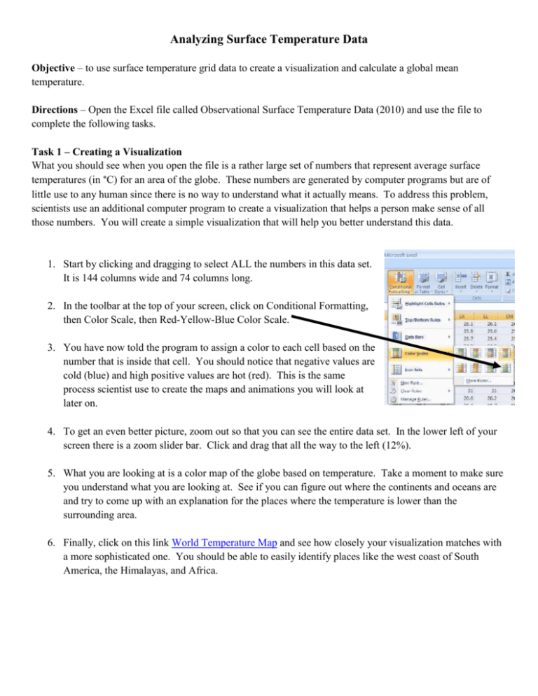
Analyzing Surface Temperature Data Objective – to use surface temperature grid data to create a visualization and calculate a global mean temperature. Directions – Open the Excel file called Observational Surface Temperature Data (2010) and use the file to complete the following tasks. Task 1 – Creating a Visualization What you should see when you open the file is a rather large set of numbers that represent average surface temperatures (in °C) for an area of the globe. These numbers are generated by computer programs but are of little use to any human since there is no way to understand what it actually means. To address this problem, scientists use an additional computer program to create a visualization that helps a person make sense of all those numbers. You will create a simple visualization that will help you better understand this data. 1. Start by clicking and dragging to select ALL the numbers in this data set. It is 144 columns wide and 74 columns long. 2. In the toolbar at the top of your screen, click on Conditional Formatting, then Color Scale, then Red-Yellow-Blue Color Scale. 3. You have now told the program to assign a color to each cell based on the number that is inside that cell. You should notice that negative values are cold (blue) and high positive values are hot (red). This is the same process scientist use to create the maps and animations you will look at later on. 4. To get an even better picture, zoom out so that you can see the entire data set. In the lower left of your screen there is a zoom slider bar. Click and drag that all the way to the left (12%). 5. What you are looking at is a color map of the globe based on temperature. Take a moment to make sure you understand what you are looking at. See if you can figure out where the continents and oceans are and try to come up with an explanation for the places where the temperature is lower than the surrounding area. 6. Finally, click on this link World Temperature Map and see how closely your visualization matches with a more sophisticated one. You should be able to easily identify places like the west coast of South America, the Himalayas, and Africa. Task 2 – Calculating a Mean Global Temperature The second thing scientists can do from a data set like this is to calculate an average (mean) global temperature. This task is meant to make you understand how that process works. Follow the steps below to use this data to calculate a global temperature. 1. First you must realize that the number in each cell is a point (Example: points A and B in the picture to the right) with latitude and longitude coordinates that is representative of an area of the globe. 2. The temperature at each point is calculated basically by taking an “average” of all the weather station data available area around that point. This is OBSERVATIONAL DATA! 3. Since the Earth is a sphere, the area at each point is not the same. For example, compare the size of the four boxes around point A to the four boxes around point B. 4. To account for this, each point is assigned a weight based on its latitude and the weighted average of all the points is taken to calculate the global mean temperature. 5. The following formula is designed to tell Excel to perform a weighted average for the entire globe and calculate a Global Mean Temperature. 6. Copy and paste this formula =SUMPRODUCT(A4:EN76*$A$131:$A$203)/SUMPRODUCT(144*$A$131:$A$203) into cell A2. 7. This gives you the global mean temperature in degrees C for the year 2010. If you would like to convert to Fahrenheit, multiply by 1.8 and add 32. 8. This process is repeated for each year to help examine the trend over a period of time. However most global temperature graphs are presented as temperature anomalies. This means the global mean temperatures are averaged over a period of about 30 years and then individual temperatures are compared to this to see if they are above or below the average. Task 3 – Summarize what you learned Type or write a summary that explains what was done in this activity, what you learned from it, and why it is important to your understanding of global climate science.


