PACFISH Riparian Goals and RMOs - Umatilla Forest Collaborative
Interim Strategies for Managing Fish-producing Watersheds
In Eastern Oregon and Washington, Idaho and Portions of California (PACFISH)
A summary of components
“RHCAs are portions of watersheds where riparian-dependent resources receive primary emphasis, and management activities are subject to specific standards and guidelines. RHCAs include traditional riparian corridors, wetlands, intermittent streams and other areas that help maintain the integrity of aquatic ecosystems by (1) influencing the delivery of coarse sediment, organic matter, and woody debris to streams (2)
providing root strength for channel stability, (3) shading the stream, and (4) protecting water quality” Appendix C-6
Kahler Project - Applicable PACFISH Appendix C Excerpts
Riparian Goals Page C-4
The goals are to maintain or restore:
(1) water quality to a degree that provides for stable and productive riparian and aquatic ecosystems;
(2) stream channel integrity, channel processes, and the sediment regime including the elements of timing, volume, and character of sediment input and transport under which the riparian and aquatic ecosystems developed;
(3) instream flows to support healthy riparian and aquatic habitats, the stability and effective function of stream channels, and the ability to route flood discharges;
(4) natural timing and variability of the water table elevation in meadows and wetlands
(5) diversity and. productivity of native and desired non-native plant communities in riparian zones;
(6) riparian vegetation to: a) provide an amount and distribution of large woody debris characteristic of natural aquatic and riparian ecosystems; b) provide adequate summer and winter thermal regulation within the riparian and aquatic zones; and c) help achieve rates of surface erosion, bank erosion, and channel migration characteristic of those under which the communities developed.
(7) riparian and aquatic habitats necessary to foster the unique genetic fish stocks that evolved within the specific geo-climatic region; and
(8) habitat to support populations of well-distributed native and desired non-native plant, vertebrate, and invertebrate populations that contribute to the viability of riparian-dependent communities.
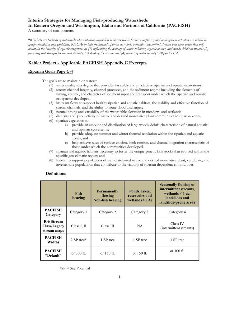
Definitions
Fish bearing
Permanently flowing
Non-fish bearing
Ponds, lakes, reservoirs and wetlands >1 Ac
Seasonally flowing or intermittent streams, wetlands < 1 ac, landslides and landslide-prone areas
PACFISH
Category
R-6 Stream
Class/Legacy stream maps
PACFISH
Widths
Category 1
Class I, II
2 SP tree*
Category 2
Class III
1 SP tree
Category 3
NA
1 SP tree
Category 4
Class IV
(intermittent streams)
1 SP tree
PACFISH
“Default” or 300 ft. or 150 ft. or 150 ft. or 100 ft.
*SP = Site Potential
1
Riparian Management Objectives (RMOs) page C-4
Interim RMOs apply to streams in watersheds with anadromous fish.
Habitat Feature Interim Objectives
Varies by channel width, see below: Pool Frequency (kf)
(all systems) wetted width in feet: number pools per mile:
Water Temperature (sf)
10 20 25 50 75 100 125 150 200
96 56 47 26 23 18 14 12 9
No measurable increase in maximum water temperature. *
Maximum water temperatures below 64F within migration and rearing habitats and below 60F within spawning habitats
Large Woody Debris (sf)
(forested systems)
Costal Californian, Oregon, and Washington.
>80 pieces per mile; >24 inch diameter; >50 foot length
East of Cascade Crest in Oregon, Washington, Idaho.
>20 pieces per mile; >12 inch diameter; >35foot length
Bank Stability (sf)
(non-forested systems)
>80 percent stable
Lower Bank Angle (sf)
(non-forested systems)
Width/Depth Ratio (sf)
(all systems) kf = key feature
>75 percent of banks with <90 degree angle
(i.e., undercut).
<10, mean wetted width divided by mean depth sf = supporting feature
Standards and Guidelines
Timber Management page C-10
TM – 1 Prohibit timber harvest, including fuelwood cutting, in Riparian Habitat Conservation Areas, except as described below. Do not include Riparian Habitat Conservation Areas in the land base used to determine the
Allowable Sale Quantity, but any volume harvested can contribute to the timber sale program. b. Apply silvicultural practices for Riparian Habitat Conservation Areas to acquire desired vegetation characteristics where needed to attain Riparian Management Objectives. Apply silvicultural practices in a manner that does not retard attainment of Riparian Management Objectives and that avoids adverse effects on listed anadromous fish.
Fire/Fuels Management page C-15-16
FM-1 Design fuel treatment and fire suppression strategies, practices, and actions so as not to prevent attainment of
Riparian Management Objectives, and to minimize disturbance of riparian ground cover and vegetation.
Strategies should recognize the role of fire in ecosystem function and identify those instances where fire suppression or fuel management actions could perpetuate or be damaging to long-term ecosystem function, listed anadromous fish, or designated critical habitat.
FM-4 Design prescribed burn projects and prescriptions to contribute to the attainment of the Riparian Management
Objectives.
2
