ReMi Results0502
advertisement
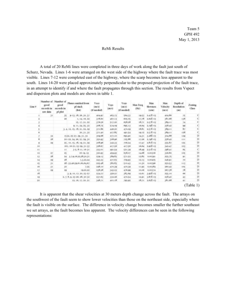
Team 5 GPH 492 May 1, 2013 ReMi Results A total of 20 ReMi lines were completed in three days of work along the fault just south of Schurz, Nevada. Lines 1-6 were arranged on the west side of the highway where the fault trace was most visible. Lines 7-12 were completed east of the highway, where the scarp becomes less apparent to the south. Lines 14-20 were placed approximately perpendicular to the proposed projection of the fault trace, in an attempt to identify if and where the fault propagates through this section. The results from Vspect and dispersion plots and models are shown in table 1. (Table 1) It is apparent that the shear velocities at 30 meters depth change across the fault. The arrays on the southwest of the fault seem to show lower velocities than those on the northeast side, especially where the fault is visible on the surface. The difference in velocity change becomes smaller the further southeast we set arrays, as the fault becomes less apparent. The velocity differences can be seen in the following representations: 574 m/s 517 m/s 467 m/s 463 m/s 446 m/s 418 m/s 460 m/s 342 m/s 308 m/s 492 m/s 417 m/s 277m/s 356 m/s 343 m/s 470 m/s 332 m/s 383 m/s 401 m/s 329 m/s 389 m/s With any field method and interpretation of data there are always limitations and errors to the analysis. The limitations involved with ReMi are that at least 50% of the microtremor waves incident on the geophone array are traveling in a direction within 30° of the array direction, that shear velocities are uniform and isotropic within each modeled layer, which is rarely ever the case. An increasing error is introduced in the depth calculations as the angle of dip of the layers departs from zero. Some significant geologic boundaries have no field-measurable seismic shear-velocity contrast, which consequently makes it impossible to detect such a boundary. Geophone placement and leveling could cause errors in the data collected, as well as inconsistency in the picking of the pf plots.


