Field name Explanation Source Data type Record ID ALA record
advertisement
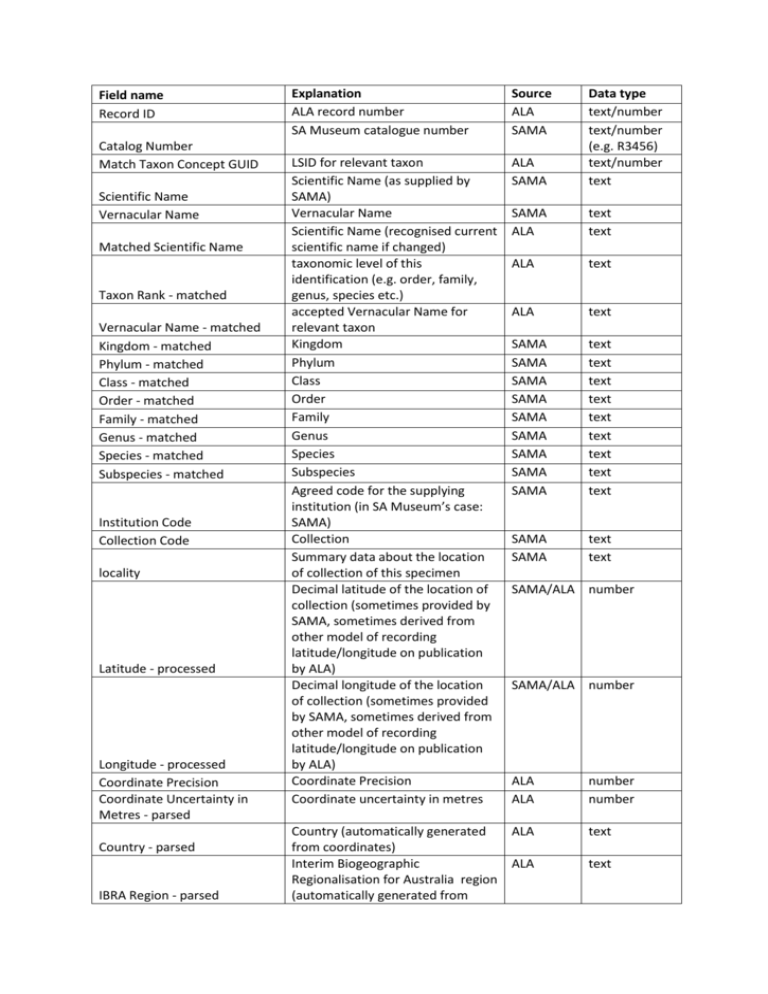
Field name Record ID Catalog Number Match Taxon Concept GUID Scientific Name Vernacular Name Matched Scientific Name Taxon Rank - matched Vernacular Name - matched Kingdom - matched Phylum - matched Class - matched Order - matched Family - matched Genus - matched Species - matched Subspecies - matched Institution Code Collection Code locality Latitude - processed Longitude - processed Coordinate Precision Coordinate Uncertainty in Metres - parsed Country - parsed IBRA Region - parsed Explanation ALA record number SA Museum catalogue number Source ALA SAMA LSID for relevant taxon Scientific Name (as supplied by SAMA) Vernacular Name Scientific Name (recognised current scientific name if changed) taxonomic level of this identification (e.g. order, family, genus, species etc.) accepted Vernacular Name for relevant taxon Kingdom Phylum Class Order Family Genus Species Subspecies Agreed code for the supplying institution (in SA Museum’s case: SAMA) Collection Summary data about the location of collection of this specimen Decimal latitude of the location of collection (sometimes provided by SAMA, sometimes derived from other model of recording latitude/longitude on publication by ALA) Decimal longitude of the location of collection (sometimes provided by SAMA, sometimes derived from other model of recording latitude/longitude on publication by ALA) Coordinate Precision Coordinate uncertainty in metres ALA SAMA Data type text/number text/number (e.g. R3456) text/number text SAMA ALA text text ALA text ALA text SAMA SAMA SAMA SAMA SAMA SAMA SAMA SAMA SAMA text text text text text text text text text SAMA SAMA text text SAMA/ALA number SAMA/ALA number ALA ALA Country (automatically generated ALA from coordinates) Interim Biogeographic ALA Regionalisation for Australia region (automatically generated from number number text text IMCRA Region - parsed State - parsed Local Government Area parsed Minimum Elevation In Metres Maximum Elevation In Metres Minimum Depth In Meters Maximum Depth In Meters individual Count Collector Year - parsed Month - parsed Day - parsed Event Date - parsed Event Time - parsed Basis Of Record Sex Preparations Information withheld during processing Data Generalised during processing Species habitats coordinates) Integrated Marine and Coastal Regionalisation of Australia region (automatically generated from coordinates) State (automatically generated from coordinates) Local Government Area (automatically generated from coordinates) Minimum Elevation In Metres Maximum Elevation In Metres Minimum Depth In Meters Maximum Depth In Meters Number of individual organisms in this registered specimen/lot Collector date of collection – year date of collection – month date of collection – day date of collection in Darwin Core format Time of collection (if supplied) Type of object (e.g. Preserved Specimen, Human Observation etc) Sex Form of object (e.g. skin, skeleton, skull, tissue sample, alcoholpreserved specimen etc) Information withheld during processing (usually for reasons of environmental sensitivity) Data Generalised during processing (usually for reasons of environmental sensitivity) Species habitats Flags outliers, intended as an indication of data quality Indicator of data quality Indicator of data quality Indicator of data quality Indicator of data quality Outlier for layer Taxon identification issue Location Quality Data Resource ID Data Resource Name Values for the following fields are machine determined TRUE or FALSE Coordinate uncertainty not Indicator of data quality specified geodetic Datum Assumed Wgs Indicator of data quality 84 Indicator of data quality inferred Duplicate Record ALA text ALA text ALA text SAMA SAMA SAMA SAMA SAMA number number number number number SAMA SAMA SAMA SAMA ALA ALA SAMA text number text number number/date string number text SAMA SAMA text text or code ALA text ALA text ALA ALA text text ALA ALA ALA ALA text text text text ALA text ALA text ALA text Collection date missing Habitat incorrect for species missing Coordinate Precision Name not in national checklists Supplied country not recognised Suspected outlier Invalid collection date Name not recognised Latitude is negated Coordinates dont match supplied state Type status not recognised Longitude is negated Supplied coordinates are zero decimal Lat Long Calculated From Verbatim Geospatial issue Indicator of data quality Indicator of data quality Indicator of data quality Names compared to National Species List coordinated by Australian Biological Resources Survey (AFD): Indicator of data quality Indicator of data quality ALA ALA ALA ALA text text text text ALA text Indicator of data quality Indicator of data quality Indicator of data quality Indicator of data quality Indicator of data quality ALA ALA ALA ALA ALA text text text text text May arise due to changing conventions in the documentation of type status: Indicator of data quality Indicator of data quality Indicator of data quality Indicator that data has undergone interpretation Indicator of data quality ALA text ALA ALA ALA text text text ALA text


