Chapter 12: Hunterdon County
advertisement
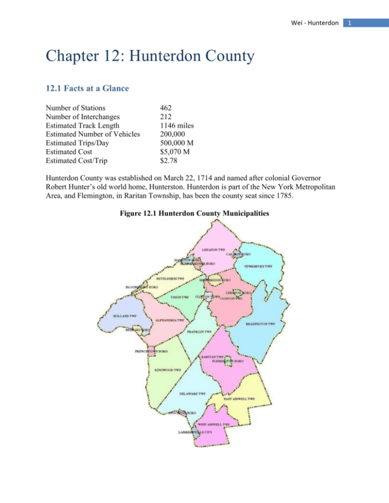
Wei - Hunterdon Chapter 12: Hunterdon County 12.1 Facts at a Glance Number of Stations Number of Interchanges Estimated Track Length Estimated Number of Vehicles Estimated Trips/Day Estimated Cost Estimated Cost/Trip 462 212 1146 miles 200,000 500,000 M $5,070 M $2.78 Hunterdon County was established on March 22, 1714 and named after colonial Governor Robert Hunter’s old world home, Hunterston. Hunterdon is part of the New York Metropolitan Area, and Flemington, in Raritan Township, has been the county seat since 1785. Figure 12.1 Hunterdon County Municipalities 1 Wei - Hunterdon 12.2 Land Characteristics Located midway between New York and Philadelphia, two of the nation’s largest metropolitan areas, Hunterdon County is only a 90 minute drive away. Despite the convenient location and resulting traffic flow through, Hunterdon is still a relatively rural area with a leading agricultural economy. Hunterdon County lies mostly in the Delaware River Valley and its tributaries and is characterized by rolling wooded hills. The eight largest of the New Jersey counties, Hunterdon encompasses a total area of 437 square miles or about 279,680 acres and is comprised of 26 municipalities that range in size and character. These include fourteen townships, ten boroughs, and Clinton Town. Lambertville, one of the oldest communities, is Hunterdon’s only city1. Several Hunterdon municipalities have no towns, only hamlets, and some townships span little more than one square mile. As shown by the land use graph below, agricultural/farming remains the predominant land use, with residential lands (discussed in 12.3) as the second largest category. Commercial or industrial development numbers just around 7,952 acres, or about 2.8% of the gross land area, as seen below in the breakdown of land use. Figure 12.2 Hunterdon County Land Use, 2006 Despite continuing development pressure, Hunterdon residents are supportive of the goal of preserving Hunterdon’s rural character2. Hunterdon County is fortunate to have numerous lands set aside for open space purposes, which has been vital in preserving the physical beauty that makes Hunterdon County unique. Design guidelines call for more compact patterns of growth to 1 2 http://www.hunterdon-chamber.org/services2.asp?service=Community%20Profiles http://www.co.hunterdon.nj.us/cadb/preserve.htm 2 Wei - Hunterdon enhance the natural environment as the dominant landscape feature and prevent low density extensions. Hunterdon has a broad open space concept encompassing rural ambiance, water resource protection, wildlife habitat, and natural recreation. Hosting 13.6% of farmland in New Jersey, the active Hunterdon County Farmland Preservation Program and Open Space Trust Fund boast the largest land area of farms3. The Hunterdon County's Agricultural Development Board maintains Farmland Preservation Programs that allow farm owners to sell development rights in exchange for a permanent requirement for the land to be available for agriculture in perpetuity. By the end of 2007, Hunterdon became the top county in the state in preserved acreage (24,244) and number of preserved farms (280), using a combination of local, county and state funding4. The chart below shows the distribution of farms by acre size, where 1 acre = 0.0015625 square miles. Figure 12.3: Hunterdon Farms by Size Figure 12.4: Tucked Away Farms in Hunterdon 3 4 http://www.co.hunterdon.nj.us/cadb.htm http://www.nj.com/hunterdon/index.ssf/2008/11/comment_sought_on_saving_farms.html 3 Wei - Hunterdon The Hunterdon County Park System comprises 24 areas and over 7,430 acres of land. There are different park area categories, and each provides a different type of environmental and public use. Deer Path Park, Hunterdon County Arboretum, the Echo Hill Section of the South Branch Nature Preserve, Mountain Farm/Teetertown Preserve, and Court Street Park at Flemington all have reservable facilities. The county has a long-term goal to add around another 10,000 acres of land to the Park System through fee simple purchases and conservation easements for public park, recreation and conservation purposes. After such an acquisition, this would place Hunterdon’s total parkland holdings at nearly 6% of the total available land area in Hunterdon County5. Some of the major parks are depicted below. Figure 12.5: Major Hunterdon Parks Most of the rural areas are located in the southern parts of Hunterdon. The suburban areas with higher density commercial and residential areas are located mostly in the central and eastern regions of the county, such as the Flemington area and along the high traffic highway corridors such as those along Route 78/202. However, Hunterdon County landscape has been gradually becoming more urbanized as the percentage of developed lands has been increasing, reaching 24% in 2001, as depicted in the table below. Development, both residential and commercial, is encouraged in more compact forms in clusters such as complexes to prevent a land-consuming sprawl. 5 http://www.co.hunterdon.nj.us/depts/parks/parks.htm 4 Wei - Hunterdon Table 12.1: Hunterdon County Landscape Change 1984-2001 in Acres 12.3 Housing Data From the 2000 census, there were 121,989 people, 43,678 households, and 32,845 families residing in Hunterdon County, resulting in a population density of 284 people per square mile.6 While still one of the least densely populated counties in New Jersey, the nation’s most densely populated state, Hunterdon has had the second fastest rate of residential growth in the state since 19807. Residents increased 13.91% from 107,776 to 121,989 between the years of 1990 and 2000, compared to a statewide growth of 8.85%. However, there are only 284 people per square mile relative to the New Jersey average of 1,127 people per square mile, giving Hunterdon the third lowest population density. Given an average of 4 trips per resident, this results in about 500,000 total trips per day. Figure 12.6: Hunterdon Municipality Population Density Given above are the corresponding municipality densities. Some of the fastest growing municipalities in Hunterdon County have been those with close connections to major 6 7 http://www.co.hunterdon.nj.us/facts.htm http://www.co.hunterdon.nj.us/pdf/cadb/DraftFarmlandPlan/Chap1.pdf 5 Wei - Hunterdon transportation corridors. As a result of their attractive locations to commuters, these areas have seen major business and residential growth as these areas have developed into a sort of bedroom community for surrounding urban areas. Below is a list of more recent population numbers along with future projections, but keep in mind that data from the 2000 Census are used for analysis. Table 12.2: Hunterdon Municipality Population Projections prepared by the Hunterdon County Planning Board, 2004 Source: U.S. Census Bureau During the 1980s, a number of higher-density residential developments, including single family homes on small lots, townhouses, apartments, and condominiums, were built throughout Hunterdon County, concentrating in areas such as Raritan Township, Union Township, Flemington, Lambertville, Clinton Township, and Readington Township. Since then, these same municipalities have continued to experience some of the largest overall percentage of commercial and industrial expansion, resulting in some of the highest values for such developments. The Town of Clinton (28%), Raritan (27%) and Readington (23%) have had some of the highest growth rates in Hunterdon recently. Due to their smaller size and more urban nature, Flemington Borough and Lambertville City have the highest densities per square mile in both population and in housing units. Flemington also houses a number of apartment complexes, which are otherwise rare in Hunterdon County. However, despite the congesting of residential areas in some parts of Hunterdon, large single-family homes on expansive lots of 3 to 15 acres still dominate new residential construction. 6 Wei - Hunterdon 12.4 Existing Transit Network 12.4.1 NJ Transit The NJ Transit is the nation's largest public transit system, and its Raritan Valley Line extends from Newark Penn Station into Hunterdon County with four stops at White House, Lebanon, Annandale, and High Bridge, where it ends. Current parking capacities for the four stations are 100, 15, 77, and 43 spots respectively. Given below are the fiscal year averages for Average Weekday Rail Passenger Boarding numbers.8 Table 12.3: Hunterdon NJ Transit Ridership Numbers Station White House Lebanon Annandale High Bridge 1999 2000 2001 2002 2003 2004 2005 2006 2007 76 12 48 48 74 14 50 53 87 19 60 55 92 16 59 55 81 14 61 45 100 12 72 54 102 16 85 60 107 19 96 68 98 18 113 76 The low ridership is explained by the fact that only nine of the thirty daily weekday trains on the Raritan Valley Line stop at any of the Hunterdon stations, whereas the preceding stops at Raritan and Somerville stations in Somerset County are serviced by twenty-eight of the trains and also have more express options. In addition, there is no service in Hunterdon on the weekends. Only four eastbound trains run in the morning, and only one runs in the afternoon. 12.4.2 LINK Figure 12.7: Hunterdon LINK The LINK is Hunterdon County’s intra-county bus transportation system that transports the general public and senior citizens and the disable at a nominal cost to popular destinations. The fleet of 30 vehicles makes about 700 trips/day and is funded by Hunterdon County, NJ Transit, and the Federal Transit Administration. Standard stops including human services programs, apartments, doctors offices, senior centers, restaurants, Hunterdon Medical Center, places of employment, and shopping areas. Rather than servicing regular routes, LINK transportation is scheduled 24 hours in advance in most cases when riders call a Central Dispatch. Curb to curb transportation is available Monday through Friday from 7:00 am to 6:00 pm. There are 18 routes 8 https://webfiles.berkeley.edu/~lensovet/njtboardingdata.htm 7 Wei - Hunterdon including a trolley-like run called the Flemington Shuffle, which provides all day service throughout the Flemington/Raritan region with has unlimited boarding fare at $2. Beginning in 2009, LINK fares have risen for the first time since 1990. The new zone-based fares were chosen as an alternative to cutting services. 12.4.3 Other Commuter Services New Jersey Transit commuter bus service is also limited. Bus lines include Clinton to Somerville (weekdays only) and Lambertville to Trenton. Bethlehem, PA-based Trans-Bridge Lines runs bus routes that stop in Clinton, Lambertville, Frenchtown, Three Bridges, Union Township, and Flemington before continuing on to New York. Yet again, daily trips are not frequent, and weekend options are limited. A map of the Annandale Square, Clinton Point, Flemington, Hunterdon Hills Playhouse, Kingwood Township, and Oldwick Park and Ride stations9 can be found at http://www.nj.gov/transportation/commuter/rideshare/pdf/hunterdonpr.pdf. In terms of aerial transportation, Hunterdon County hosts three privately owned airports available for public use: Alexandria Field, Sky Manor Airport, and Solberg Airport. 12.5 Personal Rapid Transit (PRT) Network Instituting a PRT network in Hunterdon County will provide most residents with increased access to anywhere in the county. Blending the flexibility of car travel with the economic and environmental benefits of mass transit, the PRT system provides ease of travel and convenience to Hunterdon’s residents. The isolation of most residential areas necessitates an effective transportation network. The PRT will provide access to the more remote areas of Hunterdon and more effectively manage transportation in already developed regions. The whole county will be interconnected and the destination of choice is as little as one ride away. Table 12.4: Hunterdon Roadway Miles Road Type Miles County Roadways 242 US Roadways 53 Interstate Roadways 44 State Roadways 98 Municipal Roadways 1103 Privately-owned Roads 113 Total 1653 Currently in Hunterdon County, the car is the dominant form of transportation, with a sizeable network of roads in place. Most of Hunterdon’s commercial and employment centers are concentrated along the major highways, such as Routes 78, 202/206, 29 and 31, as shown below. By providing greater access to further areas, the PRT will enable a slowdown of population clustering and help Hunterdon retain its organic attractiveness and small town charm. 9 http://www.hart-tma.com/pdf/PublicTransGuide2008.pdf 8 Wei - Hunterdon Figure 12.8: Hunterdon County Road Map Hunterdon’s existing transportation infrastructure leaves much to be desired. Hunterdon’s HART is a non-profit association dedicated to reducing traffic congestion and improving air quality in Hunterdon County, NJ. It offers incentives for carpooling and other alternative ways to go to work.10 However, public transportation is not a very popular option in Hunterdon. Many commuter options including the NJ Transit have a great lack of flexibility for not only weekdays but weekends as well. Despite the cheap fares, even Hunterdon’s LINK is not widely used by the general public and now mainly serves the elderly and disabled. As well, the LINK system is having financial troubles. Even though LINK ridership is up, revenues have failed to keep up with expenses.11 The PRT network will abet the existing infrastructure by providing more convenient access to current transit stations, including NJ Transit commuter rail stations, with PRT stations located right next to them. Commuters can then eliminate the hassle of finding parking or making an additional stop at a park and ride station by traveling directly to their destination. Current commuter bus stops at park and ride lots will also be serviced by nearby PRT stations. As well, because Hunterdon’s on-hand transportation systems are not regularly used by the general populace, in this case, the new PRT system could possibly replace the current transit system rather than just providing an easy way to access the transit stops. However, for now, the PRT stations complement, not compete with these systems, so the network is not parallel to existing systems. Shown below is the PRT network of stations and interchanges in Hunterdon County. 10 11 http://www.hart-tma.com/pdf/HARTOverviewBrochure2008.pdf http://www.nj.com/hunterdon/index.ssf/2008/12/link_fares_to_rise_for_2009.html 9 Wei - Hunterdon Figure 12.9: Hunterdon County PRT Network In the denser areas, the PRT network is based on a grid structure with loops connected through interchanges. In the more rural areas, stations are placed in wider loop routes again with interchanges connect these routes. Such a system is easily expandable in the future. Even though the system is one-way, hundreds of loops are incorporated to prevent traveling out of the way to reach a destination as shown below. As well, interchanges are connected to other interchanges to prevent circling through too many loops for further destinations. Figure 12.10: PRT Loop System Figure 12.11: Hunterdon County Productions and Attractions 10 Wei - Hunterdon As shown above, transportation demand is generally centered around the more developed regions. The colored circles show densities for productions, colored in red, and attractions, colored in yellow. The PRT system is comprised of 462 stations and 212 interchanges. Together, the system services 66.34% of productions and 81.77% of attractions. Trip estimates for residential stations are derived from population density data from the census data for all blocks in a county. Estimates for school stations are based on school enrollment and teacher numbers, and estimates for employment stations are based on employment records for surrounding businesses. For entertainment and other stations, estimates are determined with regards to location, surrounding population, and relative popularity of nearby attractions. Because attraction areas are usually clustered together and along important streets, the PRT system is able to meet a higher percentage of trips. Due to the wide variety of residential unit locations in Hunterdon County, it is extremely hard to locate PRT stations so that all residents have easy access. The convenience of PRT station locations is of vital importance, for the PRT aims to replace automobile travel, so it has to be relatively close to home. Because of population demographics, areas of higher populations and higher densities generally have more PRT stations and clusters to service the higher demand. However, because a good portion of Hunterdon’s residents are widely spread out, it is almost impossible to account for 90% of the trips without constructing too many costly stations that will not be widely used. There is an inherent tradeoff between the benefits and costs of constructing a station and the corresponding network and reaching the few people who live in the remotest areas of the county. In such a rural county, it is hard to ensure PRT service to everyone. For the more rural areas, as a rule of thumb, stations are located so that at least three houses are conveniently located within a 11 Wei - Hunterdon quarter-mile. Although there will be households that will not have easy or direct access to a PRT station, such sacrifices are necessary for the success and cost-effectiveness of the entire network. In the more rural parts of the county, such in Delaware, Franklin, Kingwood, and West Amwell townships, which have fewer than fifty housing units per square mile, the PRT will mainly serve to connect these areas with destinations in nearby larger towns, with limited inter-rural area service. As well, given the large area of Hunterdon, the cost for the PRT railway is very high. The most popular PRT stations include the Liberty Village Premium Outlets, Hunterdon Medical Center, Merck, and Hunterdon Central High School. These destinations see some of the most constant and heaviest traffic flow through in Hunterdon County, with Merck as one of the largest employers and Hunterdon Central High School as the largest public school. With the new PRT system, Hunterdon residents can instead depend on a more reliable and convenient way to travel to their necessary destinations. The PRT would be an ideal alternative since it will service the same popular destinations without the scheduling hassle. No longer will they have to schedule trips one day in advance such as with the LINK. Public transit will become a common and popular transportation option for all types of commuters, instead of merely serving those who otherwise would be mainly home-bound. As well, the low cost of riding by PRT can easily be covered even by low income families. However, the rural landscape of Hunterdon County does not allow for clustered demand and convenient station locations across the county, so the PRT system may remain a dream of the future. 12.5.1 Education Hunterdon County contains 31 school districts, including 4 regional high school districts, 1 vocational school, 1 alternative school, 1regional elementary district, 1 elementary sending district and 23 elementary districts with approximately 23,000 pupils. The 46 school buildings in Hunterdon employ approximately 2,300 full and part-time instructional, supervisory and administrative personnel. Table 12.5: Major Schools in Hunterdon County School Name # Students Hunterdon Central Regional High School 2,630 North Hunterdon Regional HS 1,525 Reading-Fleming Middle School 1,170 Voorhees High School 1,097 Delaware Valley Regional High School 873 Copper Hill School 782 Holland Brook School 765 The elementary school districts also include ten middle schools and essentially correspond to the municipalities. At least one and up to four elementary schools are located in each municipality. The high school districts include five high schools and correspond more with geographic location than population count. As a result, more rural Delaware Valley and Hunterdon South High Schools have considerably smaller enrollments. There are five private schools 12 Wei - Hunterdon in Flemington-Raritan, two in Clinton Township, and one each in Franklin Township, Lambertville City, Lebanon Borough, and Lebanon Township. The sole post-secondary education facility is Hunterdon County Polytech, a vocational school with about 446 students, including those from out of county. Because education is mandatory, all public schools, the larger private schools, and Hunterdon County Polytech in Hunterdon are directly serviced by PRT stations, which are located right on campus. The PRT system will be more efficient than the cumbersome current school bus transportation system, as it eliminates waiting time for those buses that are never on time. Also, there is no longer any more worry if a student misses his/her bus and a great reduction in congestion and pollution by all of those parents idling in a long line as they wait to drop their kids off at school 12.5.2 Employment From the census data, there are 3,968 private nonfarm establishments with paid employees 44,628 people working for private nonfarm employment in Hunterdon County. The labor force is comprised of 84,625 people of age 16 and up, but only 41% of the labor force work within Hunterdon. Most domestic jobs are related to agriculture, agriculture-related businesses or support services, such as restaurants, drug stores and markets. Hunterdon’s high-volume highway corridors have also attracted large corporations such as Merck, which is located along Route 78 and Chubb Insurance Company, which is located along Route 523. They provide easy access to growing employment in neighboring Mercer, Somerset, Middlesex, and Morris Counties. Table 12.6: Major Employers in Hunterdon County Company Name # Employees Merck Pharmaceutical Corp. 7400 Foster Wheeler Ltd. 2900 Condo Management Maintenance 2040 AM Best Co. 930 Stellex Aerostructures, Inc. 664 Kullman Industries, Inc. 550 Johanna Foods Inc. 540 Exxon Mobil Corp. 500 Mountain View Youth Correctional Facility 500 WCVH 500 Hunterdon County YMCA Inc. 375 Custom Alloy Corp. 370 New York Life Insurance Co. 350 Ingersoll-Rand Co. 331 Pilat North America Inc. 312 Speranza Brick Work Inc. 300 In 1998 in Hunterdon County, there was a 25%-75% mix of goods-producing and serviceproducing jobs among 47,100 total employments. Goods-producing jobs include construction 13 Wei - Hunterdon work and manufacturing facilities with companies such as Merck & Co. in Readington Township. Service-producing jobs include everything that is not construction or manufacturing, such as local services with engineering and management firms, health services and a wide variety of small businesses. County-wide employment projections show continued growth in such “clean” industries, which are largely dependent on good transportation and communications facilities. 12 Hunterdon’s traditional agricultural and blue collar industrial base is giving way to a whitecollar office and professional economy, following the national trend from blue to white collar employment. Hunterdon’s business establishments mapping is dominated by smaller businesses. According to census data, 95% of companies employ fewer than 25 people, while only <1% companies (around 60 companies) employ more than a hundred people. Most commercial and corporate offices and a large portion of small businesses are located in suburban centers off of the highway corridors. Smaller businesses also gather in traditional downtown areas with typical Main Street communities. With regards to employment, the PRT network serves two purposes: it directly services all of the larger employers and clusters of businesses with stations on site and it also serves as a convenient inter-modal connection for commuters to larger transportation modes to more metropolitan areas, such as the NJ Transit. Because the PRT is statewide, it will more effectively transport the other 59% of Hunterdon residents who commute for work. Table 12.7: Hunterdon County Estimated Employment by Major Industry Group, 1998-2008 Source: NJ Department of Labor, December, 2000 12.5.3 Shopping 12 http://www.co.hunterdon.nj.us/pdf/hcpb/transportation/2008/Plan/Chapter2.pdf 14 Wei - Hunterdon Due to the small nature of many Hunterdon towns, the traditional Main Street community in downtown regions is the place to go for local specialty shops. They are often clustered at the heart of the area, which is also populated with coffee shops and eateries. As opposed to intermittent strip developments, Hunterdon County favors retail centers clustered around the highway corridors to create relatively denser areas for one-stop shopping. Flemington is a popular shopping destination, offering over 100 outlet and specialty stores. One of Hunterdon’s main shopping attractions is Flemington’s Liberty Village Premium Outlets, which regularly draws crowds from nearby counties and neighboring Pennsylvania. Lambertville also is known as the Antiques Capital of NJ. Other popular destinations include Flemington Marketplace, Golden Nugget Antique Flea Market, Antiques on Union, and Hunterdon Commons. Hunterdon is purported to have some of the best outlet shopping in the country In the fall of 2008, Raritan Township saw the grand opening of the first retail stores and restaurants at the new Raritan Town Square, a 500,000 square ft mixed-use retail and commercial complex. When completed, the new square will be the largest retail center in Hunterdon County. Because of their consistency in attracting visitors, Hunterdon’s major shopping destinations are all directly serviced by PRT stations that are located in the plaza. The municipality centers also all have PRT stations, providing convenient access to the specialty shops clustering the heart of the area. Figure 12.12: Liberty Village Premium Outlets in Flemington 12.5.4 Entertainment Tourism is a vibrant industry, and Hunterdon County is full of attractions. From golfing and fishing to horse shows and antiques fairs, there is something for everyone. As well, musical, theatrical, and visual artists provide excellent performances and exhibitions throughout the year. With an extensive park system, Hunterdon is known for its natural beauty and rural charm. From nature preserves to river reservations, Hunterdon has cliffs, rivers, streams, forests, fields, and marshes for all kinds of recreational enjoyment in nature. The Hunterdon County Park system 15 Wei - Hunterdon also sponsors dozens of walks, canoe trips and educational programs. Hunterdon is also home to many numerous golf clubs, such as Heron Glen and Beaver Brook, and vineyards, such as Amwell Valley and Unionville. Hunterdon County is full of history and with history comes museums showcasing that history and a plethora of beautifully preserved historic buildings. Clinton’s Hunterdon Museum of Art and Red Mill/Hunterdon Historical Museum are among the more popular destinations. In addition to the usual movie theaters and bowling alleys, popular regional specialty attractions include the Hunterdon Hills Playhouse in Hampton, All Children's Theatre, Northlandz, and Hunterdon Ballooning. Not all parks and recreational facilities are serviced by stations. This is because of their scattered nature and variable ability to attract customers throughout the year. With no consistent stream of visitors and therefore revenue, many areas simply cannot justify the expense of constructing a PRT station and network. Recreational areas located in dense areas and next to other points of interest, such as education and shopping, will surely share PRT access. 12.5.5 Cost Cost for railway: $2 M per mile * 1146 miles = $1,146 M Cost for stations: $2 M/station * 462 stations = $924 M Cost for vehicles: $15,000K/vehicle * 200,000 vehicles = $3,000 M Total cost: $5,070 M Trips per year: 500,000 trips per day * 365 = 182.5 M trips Cost per trip for 1 year: $5,070 M/182.5 M trips = $27.78 per trip Cost per trip for 10 years: $5,070 M/1825 M trips = $2.78 per trip Figure 12.13: Hunterdon Scenery 16
