Cross-Section-Missions.doc
advertisement
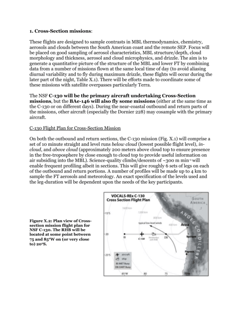
1. Cross-Section missions: These flights are designed to sample contrasts in MBL thermodynamics, chemistry, aerosols and clouds between the South American coast and the remote SEP. Focus will be placed on good sampling of aerosol characteristics, MBL structure/depth, cloud morphology and thickness, aerosol and cloud microphysics, and drizzle. The aim is to generate a quantitative picture of the structure of the MBL and lower FT by combining data from a number of missions flown at the same local time of day (to avoid aliasing diurnal variability and to fly during maximum drizzle, these flights will occur during the later part of the night, Table X.1). There will be efforts made to coordinate some of these missions with satellite overpasses particularly Terra. The NSF C-130 will be the primary aircraft undertaking Cross-Section missions, but the BAe-146 will also fly some missions (either at the same time as the C-130 or on different days). During the near-coastal outbound and return parts of the missions, other aircraft (especially the Dornier 228) may cosample with the primary aircraft. C-130 Flight Plan for Cross-Section Mission On both the outbound and return sections, the C-130 mission (Fig. X.1) will comprise a set of 10 minute straight and level runs below cloud (lowest possible flight level), incloud, and above cloud (approximately 200 meters above cloud top to ensure presence in the free-troposphere by close enough to cloud top to provide useful information on air subsiding into the MBL). Science-quality climbs/descents of ~300 m min-1 will enable frequent profiling albeit in sections. This will give roughly 6 sets of legs on each of the outbound and return portions. A number of profiles will be made up to 4 km to sample the FT aerosols and meteorology. An exact specification of the levels used and the leg-duration will be dependent upon the needs of the key participants. Figure X.2: Plan view of Crosssection mission flight plan for NSF C-130. The RHB will be located at some point between 75 and 85W on (or very close to) 20S. . Figure X.3: Cross-Section flight plan for the NSF C-130 The above-cloud-runs will be used to sample the drizzle, cloud, and MBL structure using the WCR, and to characterize the free-tropospheric chemistry, aerosol and thermodynamic structure. Below-cloud-runs will aim to determine physicochemical properties of aerosols and aerosol precursor gases (SO2 and DMS), to remotely sample the cloud and drizzle using the upward pointing 183 GHz microwave radiometer, the WCR and the lidar, and to determine lower boundary conditions (SST, surface thermodynamic and DMS fluxes, winds). An important component of the cross-section missions is to devote a portion of the flight (typically 30-40 minutes) to coincident sampling with the RHB. These coordinated sections (see Coordinated C-130/RHB Pattern figure below) will serve as a means of comparing instruments (particularly aircraft aerosol sampling and SST estimates) and will provide important in-situ context to remotely sampled cloud and drizzle properties from the RHB. In addition, these sections will be invaluable in helping to determine, using a combination of C-130 and C-band radar measurements, the dynamical structures and mesoscale organization associated with POCs and mesoscale drizzle cells in general. Figure X.3b: Coordinated C-130/RHB Pattern: Co-sampling during Cross-Section missions between C-130 (red line) and RHB (center). A RHB C-band radar PPI scan is shown for context. The decision to fly either pattern 1 or 2 will depend upon available time, meteorological conditions, and the RHB location. Following the co-sampling, the C-130 will then resume its Cross-Section mission. Pattern 1 will add 32 minutes to the direct cross-section; Pattern 2 will add 41 minutes. Multi-Platform Flight Plan for Cross-Section Mission A multi-platform Cross-Section Mission (Fig. X.3c) will be flown on some of the C-130 Cross-section missions. This will include the two UK aircraft (BAe-146 and Do-228). The idea is that the C-130 will conduct its standard Cross-Section mission but that the BAe-146 will also conduct an outbound low level flight pattern (take-off 7 am local), and will rendezvous with the C-130 at 78-80°W before flying a high level (7-8 km altitude) radiation/remote sensing leg approximately above the C-130 on the return leg. In addition the Do-228 will conduct a high level (4-5 km altitude) flight along 20°S timed to approximately overfly the C-130 on the return portion. Figure X.3c gives details of this three-aircraft mission. An IDL script to aid flight planning for this mission has been developed by Rob Wood and will be used in the field to fine tune the mission and to provide more precise takeoff times for the different aircraft. Figure X.3c: Multi-platform flight pattern for Cross-Section missions: Top panel shows C-130 outbound leg (T/O 3 am local time). Second panel shows return C-130 leg plus flight plans for BAe-146 (dashed) and Do-228 (dotted). Colors shows flight altitude windows (key in lower panel). Lowest panel shows time-longitude diagram of the flight for the three platforms. Outbound C-130 leg will include cosampling with the RHB (see Fig X.3b above). On the return the BAe-146 will release dropsondes. The Do228 flight will be timed to overfly the other aircraft during the return leg which occurs during the daytime (ETA at 75W on the return is approximately 10-11 am local time). The return leg will also coincide with Terra overpasses.
