June 2015 Field Trip Road Log - Idaho Museum of Mining and
advertisement
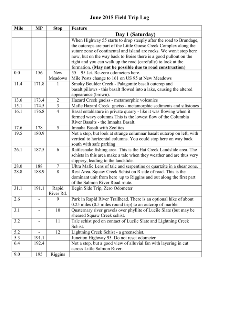
June 2015 Field Trip Log Mile MP Stop Feature Day 1 (Saturday) 0.0 11.4 13.6 15.1 16.1 17.6 19.5 26.1 28.0 28.8 31.1 2.6 3.1 3.2 5.2 5.3 6.4 9.0 When Highway 55 starts to drop steeply after the road to Brundage, the outcrops are part of the Little Goose Creek Complex along the suture zone of continental and island arc rocks. We won't stop here now, but on the way back to Boise there is a good pullout on the right and you can walk up the road (carefully) to look at the formation. (May not be possible due to road construction) 156 New 55 – 95 Jct. Re-zero odometers here. Meadows Mile Posts change to 161 on US 95 at New Meadows 171.8 1 Smoky Boulder Creek - Palagonite basalt outcrop and basalt.pillows - this basalt flowed into a lake, causing the altered appearance (brown). 173.4 2 Hazard Creek gneiss - metamorphic volcanics 174.5 3 Mafic Hazard Creek gneiss - metamorphic sediments and siltstones 176.8 4 Basal entablature in private quarry - like it was flowing when it formed wavy columns.This is the lowest flow of the Columbia River Basalts - the Imnaha Basalt. 178 5 Imnaha Basalt with Zeolites 180.9 Not a stop, but look at strange columnar basalt outcrop on left, with vertical to horizontal columns. You could stop here on way back south with safe parking 187.5 6 Rattlesnake fishing area. This is the Hat Creek Landslide area. The schists in this area make a talc when they weather and are thus very slippery, leading to the landslide. 188 7 Ultra Mafic Lens of talc and serpentine or quartzite in a shear zone. 188.9 8 Rest Area. Squaw Creek Schist on R side of road. This is the dominant unit from here up to Riggins and out along the first part of the Salmon River Road route. 191.1 Rapid Begin Side Trip, Zero Odometer River Rd. 9 Park in Rapid River Trailhead. There is an optional hike of about 0.25 miles (0.5 miles round trip) to an outcrop of marble. 10 Quaternary river gravels over phyllite of Lucile Slate (but may be sheared Squaw Creek schist. 11 Talc schist pod on contact of Lucile Slate and Lightning Creek Schist. 12 Lightning Creek Schist - a greenschist. 191.1 Junction Highway 95. Do not reset odometer 192.4 Not a stop, but a good view of alluvial fan with layering in cut across Little Salmon River. 195 Riggins Day 2 (Sunday) 0.0 0.05 0.4 - Riggins 1 2 4.2 - 3 6.2 - 4 9.0 13.5 5 - 6 1.9 197.3 7 2.1 197.5 8 5.4 200.1 9 27.0 10 8.1 203.1 11 8.9 203.9 12 10.1 205 15.5 210.1 15.9 210.7 13 Little Salmon River Bridge. Zero Odometer Massive Squaw Creek schist just across the bridge Massive Salmon River gravels with imbrication (they are tilted downstream). Also from this stop, looking back to the west, there is a ziz-zag fold in the Squaw Creek Schist visible on the hillside. Berg Creek amphibolite; this is a hornblende and garnet metasediment. Garnet-bearing Lightning Creek schist Walk back to beginning of parking area and then across the road. The garnets have light halos. There is a small "slickenslide" evident in the schist, indicating fault movement. Riggins Hot Springs across the river. The outcrop here is the beginning of the shear zone of the accreted terranes. There are also granite and pegmatite intrusions in the gneissic rocks. Here, just across the Manning Bridge, we have crossed the shear zone and are in the Crevice Pluton of the archaic North American craton. Junction Hwy. 95. Lunch in Riggins Zero odometer leaving lunch spot. South Goff Bridge. This is a dramatic location for hornblende crystals in the schist. North Goff Bridge. Park just beyond bridge on left. This is a complex sequence of ultramafic rocks from Squaw Creek Schist to light talc carbonates, to antigorite serpentinite (see diagram). Park on left. Lightning Creek schist with "agglomerate" clasts of green schist in big boulders on side of parking area. Park at North end of fruit stand lot and walk north to Fiddle Creek Schist - this is a "white" schist that is not very "schisty." Martin Bridge Limestone - pull out on right onto old highway and turn left to the outcrop. The limestone is really metamorphosed into marble. Rest Stop and Lucile slate. The outcrop is across the road and slightly north of the rest stop, but there is no parking there - walk from the rest stop parking area. Not a stop, but look at Gold Mine in river gravels on Right - a death trap! Steelhead Inn, site of 1998 landslide, evident from "stone catcher" fencing on right. No place to stop here but we can look back from the Long Gulch access road. Turn off on Long Gulch Access Road. Long Gulch landslide is visible looking back south. Drive a little farther to outhouse, Mt. Mazama ash visible here as a white band in the road cut across the road. We turn around after this stop.


